Columbus gives the clearest starting point for understanding Lowndes County in eastern Mississippi. You can download the matching high-resolution A3 JPG maps from this page in one ZIP, while the WebP versions remain convenient for quick viewing in the article. US 82 crosses the Columbus area from west to east and US 45 provides the main north-south reference, with state highways extending toward Caledonia and the Alabama side of the county. The sections below use those roads and communities as a starting point before moving to the Tombigbee River system and the county’s elevation differences.
The county changes noticeably from one side to another. Columbus and the Tombigbee River occupy a relatively low central and southeastern corridor, while the northeastern and eastern margins rise into more pronounced hills. Caledonia lies north of Columbus, Artesia is west and slightly south of the city, and Crawford is farther southwest. The eastern county line is also the Mississippi-Alabama state boundary, making Lowndes County a useful place to compare settlement, transportation, water, and terrain within a relatively compact area.
Table of Contents
Columbus, US 82, and the shape of Lowndes County
The county reference map places Columbus just north of the county’s midsection and shows the densest concentration of roads and built-up area there. US 82 runs through Columbus on a west-east course and continues toward Alabama, while US 45 approaches from the southwest and links the city with points to the north. MS 12 is a useful guide toward Caledonia, and MS 50 helps orient the area immediately east of Columbus. Several smaller numbered routes appear as well, but these four major road references are enough to establish the overall travel pattern before examining local detail.
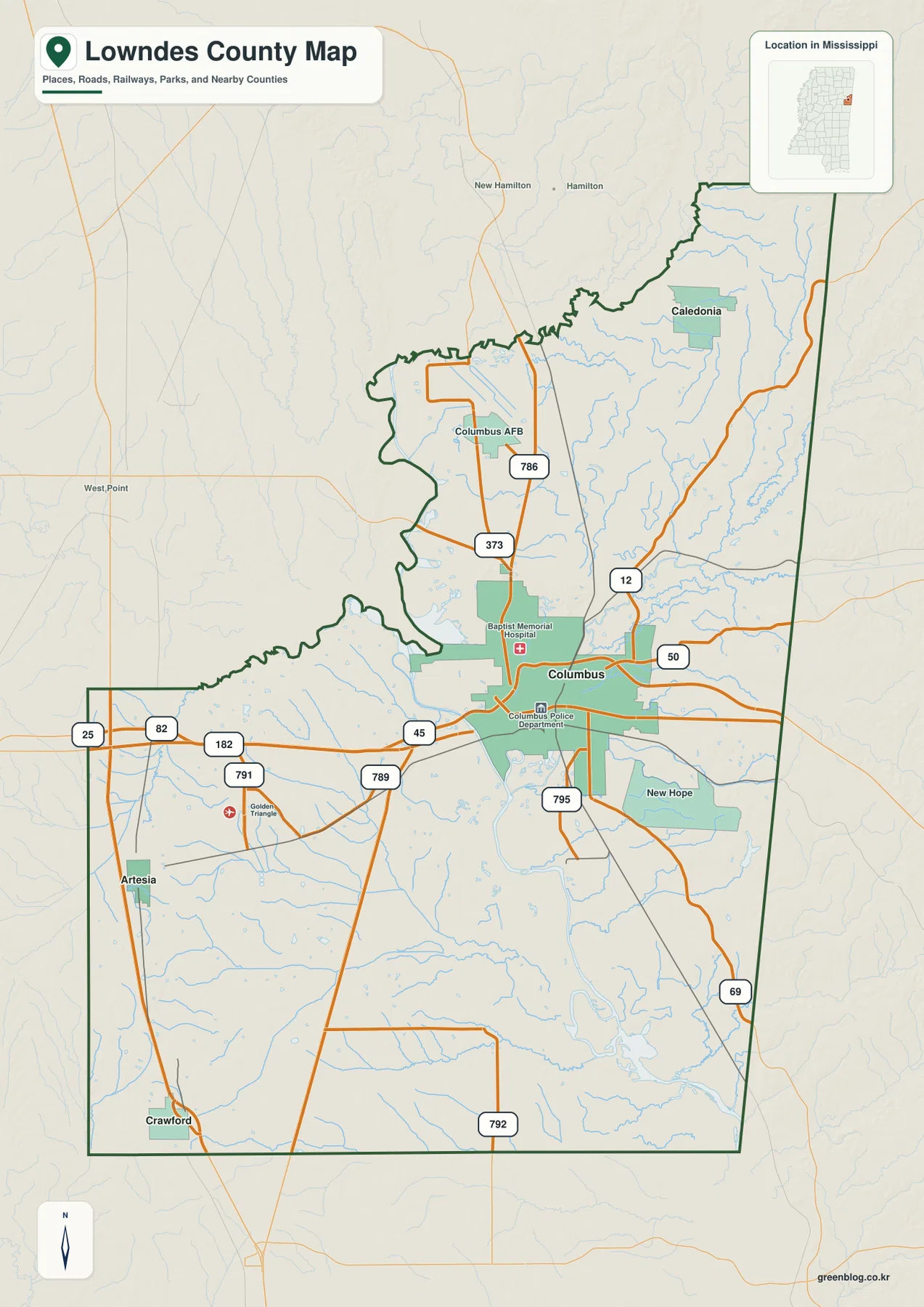
Several additional labels help explain the county beyond the highway network. Columbus Air Force Base appears north of the city, Caledonia is farther northeast, and New Hope is shown southeast of Columbus. Artesia and Crawford occupy the western and southwestern part of the county, where the settlement pattern is more dispersed. The boundary itself is irregular on the west and northwest, then extends along a much straighter state-line edge on the east. This shape matters when reading nearby place names because locations just outside the boundary can appear close to a Lowndes County road even though they belong to another county or state.
| Reference | Value or map detail |
|---|---|
| County seat | Columbus |
| FIPS code | 28087 |
| 2020 census population | 58,879 |
| July 2025 population estimate | 57,346 |
| 2025 Gazetteer land area | 506.068 sq mi |
| 2025 Gazetteer water area | 11.013 sq mi |
| Primary road references | US 45, US 82, MS 12, MS 50 |
| Elevation map range | About 42–137 m; mean about 67 m |
The population figures use different reference dates, so they should not be treated as measurements taken at the same moment. Using the 2020 population with the 2025 Gazetteer land area produces a countywide figure of roughly 116.3 residents per square mile. That number is only an area-wide average. The maps make clear that settlement is concentrated much more strongly around Columbus and major roads than in the outer rural portions of the county.
How Caledonia, Artesia, and Crawford relate to Columbus
The city-connections map simplifies the county by treating Columbus as the hub and showing three selected places around it. Caledonia is about 12 miles from Columbus by straight-line measurement, Artesia about 16 miles, and Crawford about 20 miles. These are not driving distances. They are direct point-to-point distances used to compare the relative spacing of the communities, so an actual road trip will usually cover a longer route and may follow a different direction than the straight connector implies.
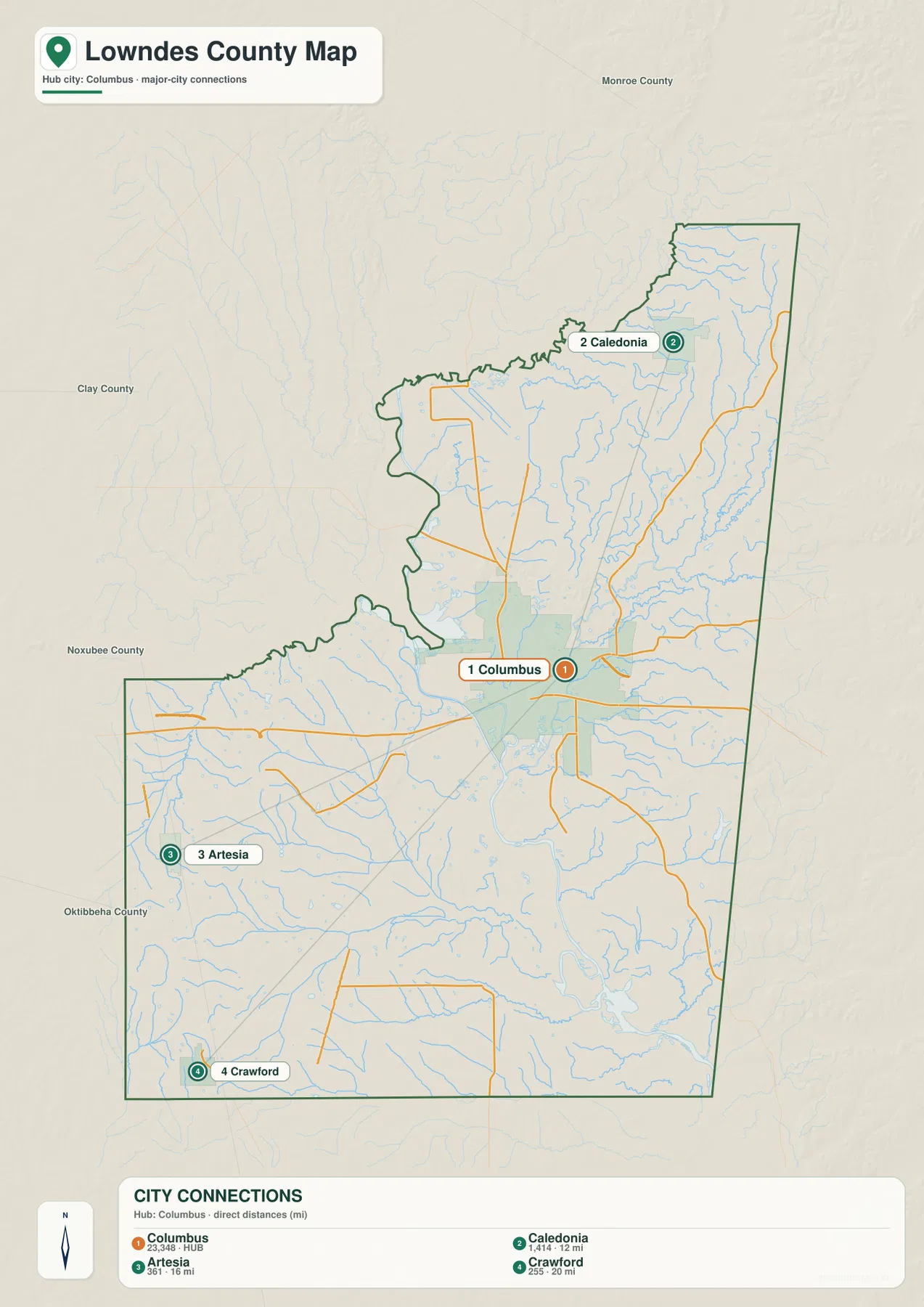
The locations form a useful three-direction comparison. Caledonia lies north of Columbus toward the narrower upper part of the county. Artesia sits west and slightly south of Columbus, while Crawford is farther southwest near the southern edge. New Hope is not one of the numbered city-connection points, but it appears on the county reference map southeast of Columbus and adds another settlement reference on the opposite side of the hub. Together, the maps show that Columbus is not simply at one end of a line of towns; it is the dominant center with smaller communities distributed in several directions.
Neighboring county labels provide another layer of orientation. Monroe County is north, Clay County is to the west and northwest, and Noxubee and Oktibbeha counties appear toward the western and southwestern side of the map. The eastern edge is different because it meets Alabama rather than another Mississippi county. When a trip crosses the state line or heads toward a neighboring county, the county boundary map is therefore a better reference than the city-connection distance alone.
Tombigbee River, Buttahatchee River, and the smaller creeks
Water is one of the strongest geographic features in Lowndes County. The water map shows the Tombigbee River running through the central part of the county and continuing toward the southeast. Near the northwest side, the Buttahatchee River approaches the county boundary, while a network of smaller streams feeds the larger river system from both sides. Yellow Creek is prominent along the eastern side, and Magby Creek and Mc Cray Creek appear farther inward. In the southern half, Ellis Creek, Gilmer Creek, Cedar Creek, and James Creek add several more named branches.
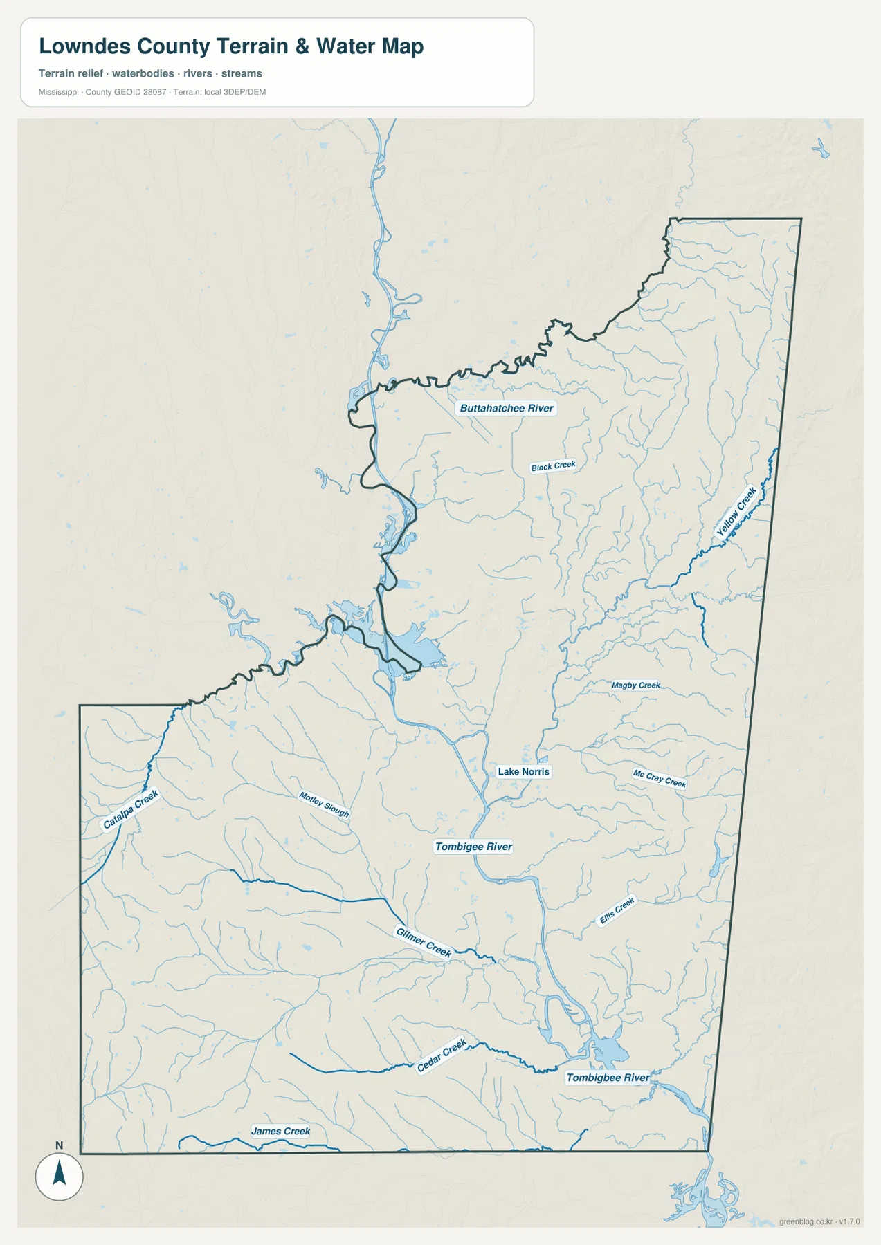
Lake Norris is labeled east of the Tombigbee in the central part of the county. On the western side, Catalpa Creek and Motley Slough provide additional references that are easy to miss on the general road map. The point of this map is not simply to collect water names. It shows where the larger river corridor sits relative to smaller tributaries and to the county boundary, which becomes especially useful when compared with the elevation map.
The source material for the current article also places the Columbus-area water system within the broader Tennessee-Tombigbee Waterway context. That navigation system and the natural Tombigbee River are related but should not be treated as interchangeable labels for every mapped water segment. The supplied water map is a geographic reference for rivers, creeks, lakes, and terrain. It does not show flood depth, current river stage, legal waterfront boundaries, or navigation conditions, so those questions require separate current data from the appropriate agency.
A low river corridor beside higher eastern hills
The elevation map gives Lowndes County a very different appearance from the road map. Its stated actual elevation range is approximately 42 to 137 meters, with a mean near 67 meters. The highest terrain is concentrated most clearly in the northeast and along parts of the eastern edge, where orange and brown ridges stand out. Those areas contrast sharply with the broad green lowlands running through the center and southeast, close to the Tombigbee River corridor.
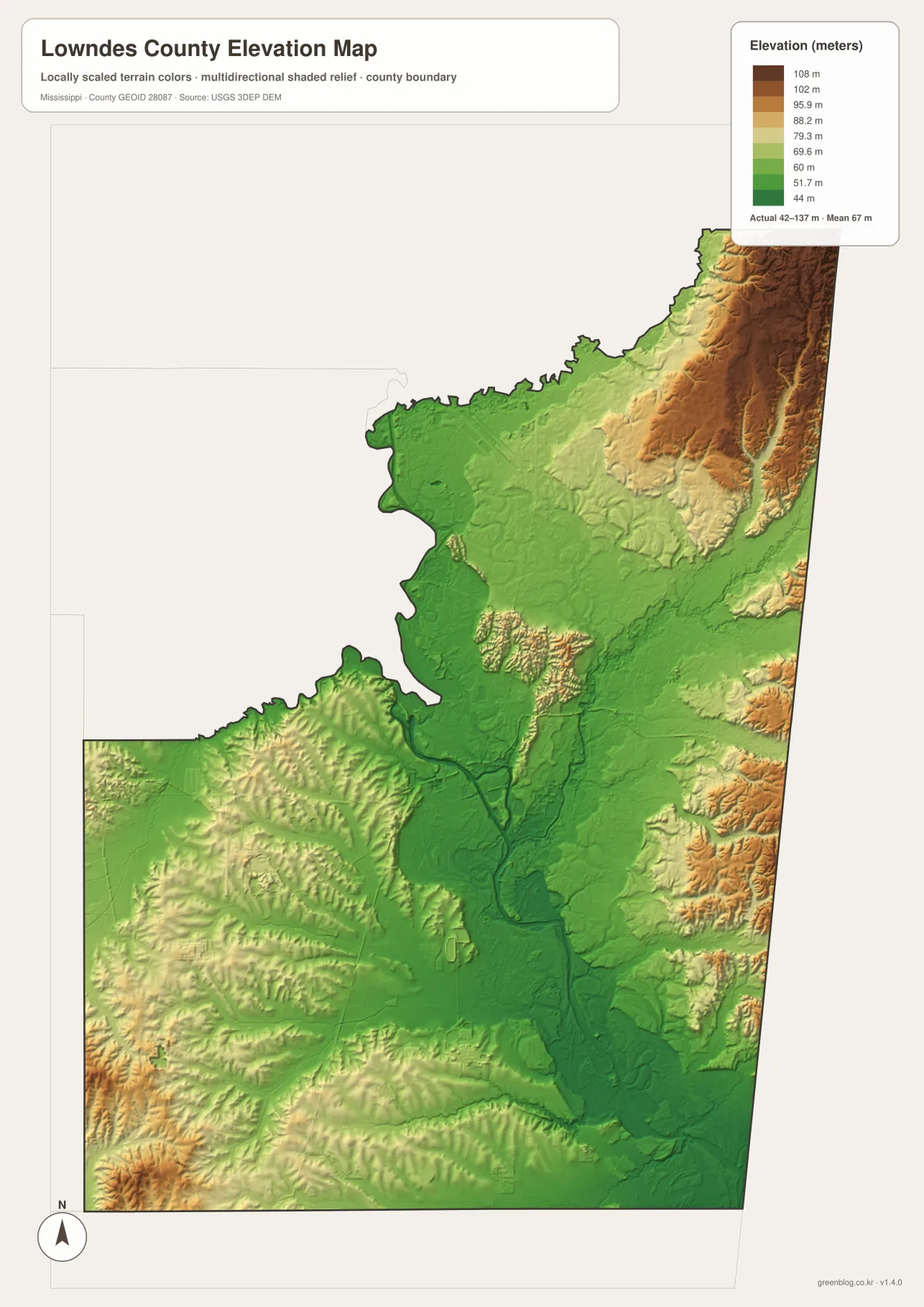
The western and southwestern portions are more varied than a flat-color map might suggest. Small ridges and rolling areas appear among the lower ground, but they do not form the broad high zone seen on the eastern side. The Tombigbee corridor remains the most continuous low feature, and its shape corresponds closely with the river path on the water map. This comparison is one of the clearest examples of why the maps are more useful together than separately: the water map identifies the named river, while the elevation view shows the lower land that accompanies it.
This elevation surface is intended for county-scale comparison, not for surveying a parcel or determining the exact height of a building, road, or construction site. The 42–137 meter range describes the terrain represented in the supplied county dataset. Engineering, drainage design, or other work that depends on precise elevations should use the original elevation data and, when necessary, professional field measurements.
What the four map views reveal when used together
Each map answers a different practical question without requiring the reader to work through a dense GIS interface. The reference map is the quickest way to locate Columbus, US 82, US 45, Caledonia, Artesia, Crawford, and the state line. The city-connections map strips away much of that detail and makes relative direction and straight-line distance easier to compare. The water map brings the Tombigbee River and its tributaries forward, while the elevation map shows why the central river corridor differs physically from the higher northeast.
That combination also helps explain the setting of Columbus. The city lies where major roads converge close to a broad river system and lower terrain. Caledonia is north of the hub toward the higher eastern and northeastern side, while Artesia and Crawford sit across the western and southwestern part of the county. The maps do not prove why every road or settlement developed in a particular location, but they do provide enough geographic context to see how transportation, water, and relief line up around the county’s main communities.
- Use the county map first when you need road direction, community labels, or the Mississippi-Alabama boundary.
- Use the city-connections view to compare Columbus with Caledonia, Artesia, and Crawford; remember that the listed mileage is straight-line distance.
- Use the water map to locate the Tombigbee River, Buttahatchee River, Yellow Creek, Lake Norris, and selected tributaries.
- Use the elevation map to compare the higher northeastern hills with the low central and southeastern river corridor.
The downloadable archive contains four high-resolution A3 JPG files corresponding to the map views used in the article. The WebP images on the page are convenient for quick viewing, while the JPG files are better suited to printing, zooming in on labels, or placing a map into a document or presentation. These are general reference maps rather than legal boundary, survey, navigation, or live-routing products.
Frequently Asked Questions
Are the distances from Columbus to Caledonia, Artesia, and Crawford driving distances?
No. The city-connections map uses straight-line distances from Columbus: about 12 miles to Caledonia, 16 miles to Artesia, and 20 miles to Crawford. Road mileage will normally be different because actual routes follow the street and highway network rather than a direct line.
Where is the highest terrain shown in Lowndes County?
The elevation map places the most prominent high ground in the northeastern and eastern parts of the county. The central and southeastern Tombigbee River corridor is much lower. The map reports an actual county range of roughly 42–137 meters and a mean elevation of about 67 meters.
Can the water map be used as a flood or navigation map?
No. It is a reference map for the relative locations of the Tombigbee River, Buttahatchee River, creeks, lakes, and surrounding terrain. It does not provide flood depths, current water levels, channel conditions, or legal waterfront information.
Sources and reference data
Population and area values are based on U.S. Census Bureau material supplied with the package. Road, water, and elevation descriptions were checked against the provided maps and the official reference links below. For current road conditions, detailed hydrography, or precise elevation work, consult the original agency data directly.
- U.S. Census Bureau Lowndes County QuickFacts
- U.S. Census Bureau Gazetteer Files
- Mississippi Department of Transportation official highway map
- U.S. Army Corps of Engineers Tennessee-Tombigbee Waterway
- USGS National Hydrography
- USGS 3D Elevation Program
Map File Information
The ZIP contains the Lowndes County reference, city, water, and elevation maps as high-resolution A3 JPG files.
- Included Files: 4 map JPGs
Related Maps
Green Map creates custom-edited map images using open geographic data sources such as geoBoundaries, Natural Earth, OpenStreetMap, and government open data. These maps are edited visual materials, not raw data files, and are provided for education, documents, presentations, and graphic reference.