Moore County North Carolina Map visitors can use this page to locate Carthage, Pinehurst, Southern Pines, Aberdeen, Robbins, Whispering Pines, and other communities while comparing the road network with rivers, creeks, lakes, and terrain. The article includes a general county map, a city-location map, and a terrain-and-water map. The same three map types are available as high-resolution A3 JPG files in one ZIP download, so the browser images can be used for quick orientation and the larger originals for printing or close inspection.
Carthage is the county seat and a useful central reference, but the maps show a different settlement pattern in southern Moore County. Pinehurst, Southern Pines, and Aberdeen sit relatively close together, while Robbins is much farther north and Cameron lies toward the east. The package’s existing county material describes the southern area as part of the Sandhills resort and residential setting, which helps explain why a map centered only on Carthage would miss much of the county’s visible population and road concentration.
Table of Contents
Carthage is a practical road reference between the northern and southern parts of the county
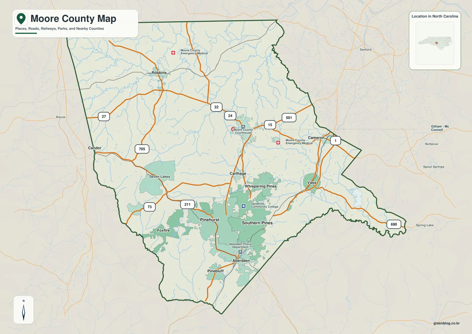
The general county map places Carthage near the middle, with several roads spreading in different directions. Route 22 approaches the area from the north, Route 24 crosses nearby, and the 15 and 501 shields appear east of the center. South and southwest of Carthage, Route 211 becomes an important reference around Pinehurst, while Route 73 helps with the western side of the southern county. This road pattern makes Carthage a useful starting point even though it is not the largest settlement shown.
Moving south from Carthage changes the map quickly. Pinehurst, Southern Pines, and Aberdeen occupy a relatively compact cluster with several roads connecting them, and the built-up shading is broader than it is around the northern towns. Whispering Pines lies east of Carthage and north of Southern Pines, while Vass appears farther east. Seven Lakes and Foxfire provide additional references to the west and southwest of Pinehurst.
The northern half is more spread out. Robbins is the clearest named town in the northwest, with Route 27 and Route 705 providing useful road references, while Route 22 continues toward the central part of the county. The general map also labels places beyond Moore County, including Sanford to the northeast and Biscoe and Candor to the west. These outside names should be used as directional references rather than treated as internal county destinations.
On the east and southeast, Route 1 is a strong visual guide through the Cameron and Vass side of the map and toward the Southern Pines-Aberdeen area. A 690 shield is also shown near the southeastern edge. Reading the county by these directional road groups—northwest, central, southern, and eastern—works better than trying to use one highway as the organizing line for the entire county.
Pinehurst, Southern Pines, and Aberdeen form the clearest southern city cluster
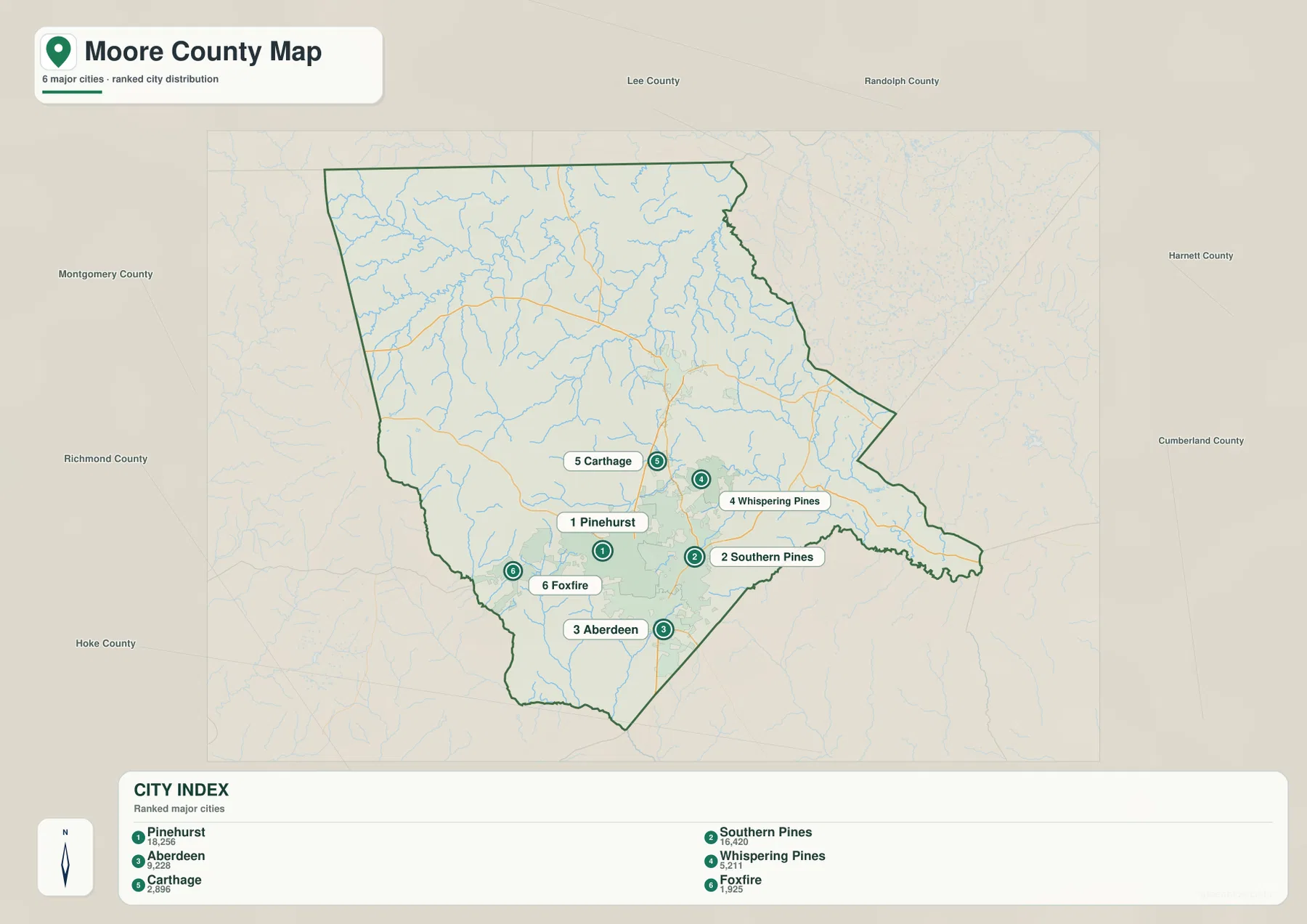
The city map makes the southern concentration especially easy to see. Pinehurst is ranked first, Southern Pines second, and Aberdeen third, with all three markers positioned close together in the lower half of the county. Whispering Pines is fourth and lies to their north and east, while Carthage is fifth in the central area. Foxfire is sixth and sits west of the main southern cluster.
Those numbers are best treated as the map’s provided city ranking, not as an administrative hierarchy. Carthage remains the county seat, yet Pinehurst and Southern Pines are shown as larger settlement references in the package’s city index. This distinction is useful because a visitor looking for county government will naturally begin with Carthage, while someone trying to understand the densest group of named communities will spend more time around Pinehurst, Southern Pines, and Aberdeen.
Whispering Pines adds another useful orientation point because it sits between the central and southern areas but farther east. Foxfire occupies a separate southwestern position, and Seven Lakes is labeled on the general map to the northwest of Pinehurst. Together, these places show that even southern Moore County is not one single compact center; several communities are spread across the Sandhills landscape.
The city map also places surrounding county names around Moore County, including Montgomery, Richmond, Hoke, Lee, Randolph, Harnett, and Cumberland. These labels provide broad regional orientation. The western and southwestern sides point toward Montgomery and Richmond, the northeast toward Lee, and the east and southeast toward Harnett and Cumberland.
Deep River and the northern creeks reveal a detailed drainage network away from the city cluster
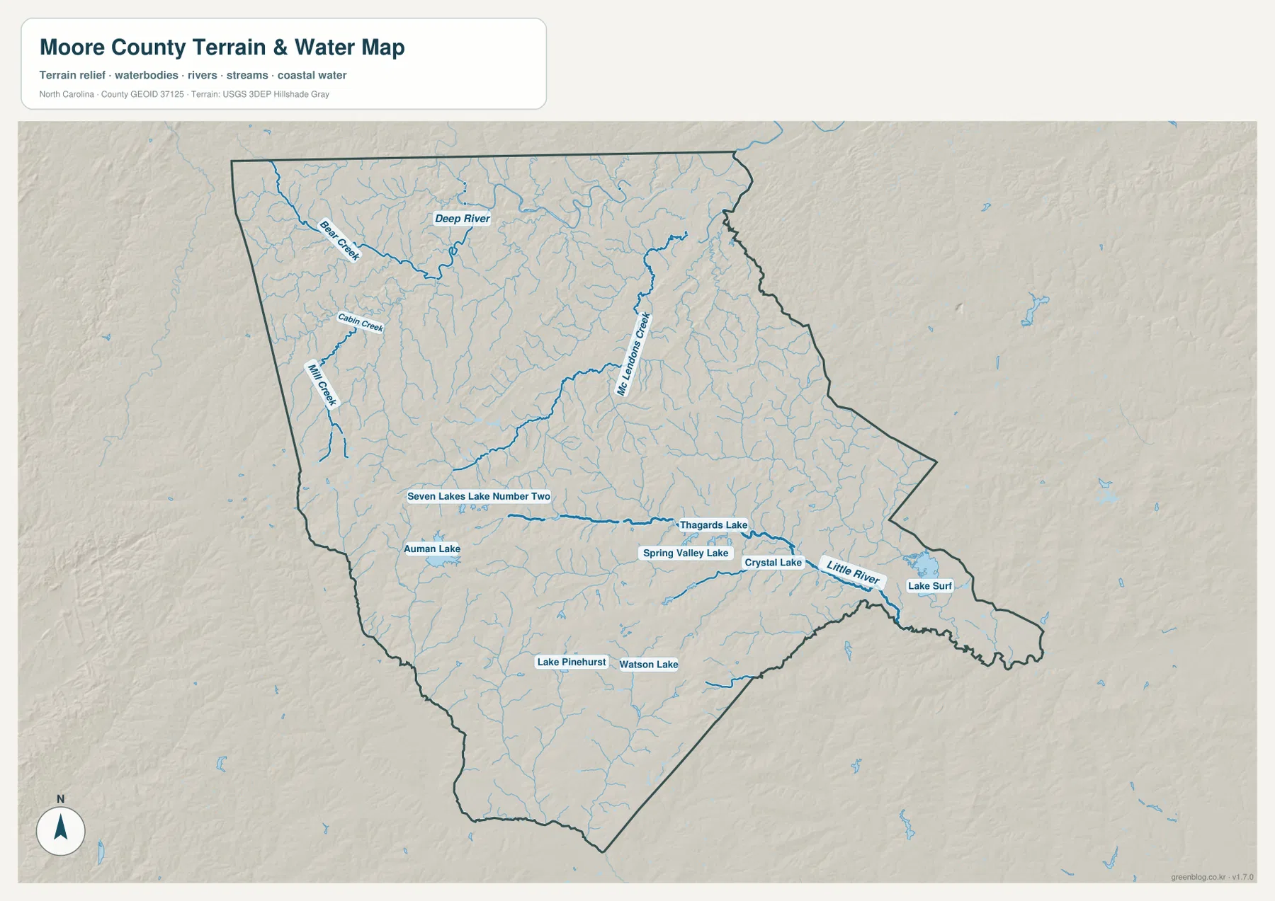
The terrain-and-water map changes the emphasis from roads to drainage. Deep River is a prominent named feature across the northern part of Moore County. Bear Creek approaches from the northwest, while Cabin Creek and Mill Creek occupy separate nearby valleys. With road labels removed, the northern half no longer looks like empty space between towns; it becomes a dense pattern of small tributaries and low valleys.
Deep River bends through the northern landscape rather than following a straight county-wide line. Numerous smaller streams join it from both sides, which helps explain why local roads on the general map curve and change direction. For users trying to understand the Robbins side of the county, the water map provides a useful physical reference that the city map cannot show.
Bear Creek, Cabin Creek, and Mill Creek are valuable for more detailed orientation because each is labeled separately. They are much smaller than Deep River, but they can help identify a particular part of the northwestern county where city names are sparse. Comparing their positions with the dark county boundary also prevents confusion with streams that continue outside Moore County.
McLendons Creek and Little River organize the central and southeastern water map
McLendons Creek is one of the longest named waterways shown through the central-northern interior. It follows a different course from Deep River and receives many small tributaries along the way. When Carthage and Whispering Pines are first located on the road map, switching to the water map makes it easier to see the creek system underlying the same central part of the county.
Little River becomes the stronger reference in the southeast. It runs near the eastern county edge and is associated with the broad water feature labeled Lake Surf. This section of the map is physically different from the southern Pinehurst road cluster, even though both are in the lower half of the county. The river-and-boundary relationship is much clearer on the terrain map than on the general road view.
Between McLendons Creek and Little River, many smaller unnamed tributaries fill the terrain. The shaded relief is gentle compared with western North Carolina mountain counties, but repeated low ridges and shallow valleys are still visible. That surface helps explain why the drainage network branches so widely across a landscape that might otherwise appear almost flat on a simple road map.
Small lakes around Pinehurst and Seven Lakes add detail to the Sandhills landscape
Several named water bodies appear in the southern and west-central parts of the terrain map. Lake Pinehurst and Watson Lake sit near the Pinehurst side, while Auman Lake and Seven Lakes Lake Number Two provide references farther west and northwest. Thagards Lake, Spring Valley Lake, and Crystal Lake form another group across the central-southern area. These smaller waters are useful local landmarks even though they are very different in scale from a major river.
The general map shows the Pinehurst-Seven Lakes area mainly through roads and developed place shading, while the terrain map reveals how many separate lakes and tributaries occupy the same broad area. Looking at both views avoids the impression that southern Moore County is only an urban or resort corridor. Water features and low-relief terrain remain woven through the communities.
The package’s existing Moore County material places the county in the Sandhills setting. The hillshade supports a landscape of low, repeated ridges and shallow drainage lines rather than high mountains. That physical background is useful when reading the road network because it explains why many routes and streams curve through the county instead of forming a simple rectangular grid.
Different road numbers are useful for the southern city cluster, the north, and the eastern side
For Pinehurst, Southern Pines, and Aberdeen, the most visible road references include 1, 15, 501, and 211. These routes help connect the southern settlements and provide a straightforward way to move between the city map and the more detailed general county map. Route 73 is useful farther west near the Pinehurst-Seven Lakes side.
The northwestern part has a different road pattern. Route 22 extends north from the Carthage area, while 27 and 705 help locate the Robbins side of the county. Because the named towns are farther apart there, combining road numbers with Deep River and the smaller creeks can provide better orientation than relying on settlement labels alone.
On the east, Route 1 is the clearest long-distance reference through the Cameron-Vass side and toward Southern Pines and Aberdeen. The 690 shield is also visible near the southeastern boundary. No single route organizes all of Moore County, so the map becomes easier to use when the trip is first divided into the southern city cluster, the northern Robbins area, or the eastern Cameron-Vass side.
Use the general map for roads, the city map for settlement comparison, and the water map for physical detail
Start with the general county map if you need an all-purpose reference for Carthage, Pinehurst, Southern Pines, Aberdeen, Robbins, Whispering Pines, Vass, Seven Lakes, major roads, and the county outline. It is the fastest way to determine which part of Moore County a place occupies and which road numbers are likely to matter.
The city map is cleaner when the main question is how the major communities compare in position. It makes the southern Pinehurst-Southern Pines-Aberdeen grouping obvious and shows Carthage farther north. Choose the terrain-and-water map when rivers, creeks, small lakes, or relief matter more than roads; Deep River, McLendons Creek, Little River, Lake Pinehurst, Auman Lake, and other named water features are much easier to locate there.
The downloadable ZIP contains high-resolution A3 JPG originals for the same general county map, city map, and terrain-and-water map shown on the page. The WebP images are optimized for browsing, while the JPG originals provide larger labels and linework for printing, classroom use, personal study, travel planning, or offline reference. Preview the map you need here and use the ZIP when the larger original is more practical.
Frequently Asked Questions
Why do Carthage and the Pinehurst-Southern Pines area serve different map purposes?
Carthage is the county seat and a strong central reference, while Pinehurst, Southern Pines, and Aberdeen form the most obvious cluster of major communities on the city map. Looking at both areas keeps the administrative center separate from the southern concentration of settlements and roads.
Where can I find Deep River, Little River, and the lakes around Pinehurst?
The terrain-and-water map is the best view. It labels Deep River in the north, McLendons Creek through the interior, Little River in the southeast, and lakes such as Lake Pinehurst, Auman Lake, Thagards Lake, Spring Valley Lake, and Crystal Lake. These features are easier to see there than on the road-focused county map.
What files are included in the downloadable ZIP?
The ZIP includes high-resolution A3 JPG files for the general Moore County map, the city map, and the terrain-and-water map. They match the map types shown in the article but use larger originals than the browser previews, making them more suitable for printing or close inspection.
Sources and Reference Data
This article is based first on the maps, package notes, and validation material supplied for this Moore County rewrite. The following public sources provide additional county background, boundary data, and hydrography references.
Map File Information
This ZIP contains high-resolution A3 JPG versions of the Moore County general map, city map, and terrain-and-water map. The larger originals make Carthage, the southern city cluster, major roads, Deep River, Little River, lakes, and smaller creeks easier to inspect or print.
- Included Files: Moore County general map, city map, and terrain-and-water map
- File Type: Three high-resolution A3 JPG files in one ZIP archive
- Intended Use: Printing, education, presentations, and map-based projects
Related Maps
Green Map creates custom-edited map images using open geographic data sources such as geoBoundaries, Natural Earth, OpenStreetMap, and government open data.
These maps are edited visual materials, not raw data files, and are provided for education, documents, presentations, and graphic reference.