This Posey County Map page lets you download high-resolution JPG files and compare the county’s main settlements, roads, waterways, and elevation in one place. Posey County occupies Indiana’s far southwestern corner, with the Wabash River along the west and the Ohio River along the south. Mount Vernon is the county seat near the southern riverfront, New Harmony sits near the Wabash in the northwest, and Poseyville, Griffin, and Cynthiana are spread across the north. The WebP versions below are convenient for on-page viewing, while the downloadable ZIP contains larger originals for closer inspection and printing.
The shape of the county makes more sense if the two major rivers are located before the smaller towns. Posey County Government describes the Wabash as the western border and the Ohio as the southern border. On the supplied county map, those river edges bend repeatedly, creating long projections and recesses on the west and southwest. The northern and eastern boundaries are much more regular. Mount Vernon and New Harmony then provide two easy anchors: one near the Ohio River in the south and the other near the Wabash in the northwest.
The interior is not uniformly flat. The elevation map shows broad low ground beside the Wabash and Ohio rivers, but the north-central and eastern portions contain recurring ridges and rolling higher ground separated by stream valleys. That contrast is one reason the four supplied maps work well together. A settlement can first be located on the general map, compared with Mount Vernon on the city-connections map, matched to nearby creeks or lakes on the water map, and then checked against the elevation colors.
Table of Contents
Reading Posey County from its river-shaped edges
Mount Vernon is the strongest southern reference point on the general county map. The county government identifies it as the county seat, and several numbered roads meet in or near the city. The route labeled 69 is especially useful for following the county northward from Mount Vernon, while the 62 corridor helps orient the lower eastern side. These labels are best treated as broad location guides rather than live navigation. Their value on this page is that they connect the southern population center with the quieter interior and the smaller communities farther north.
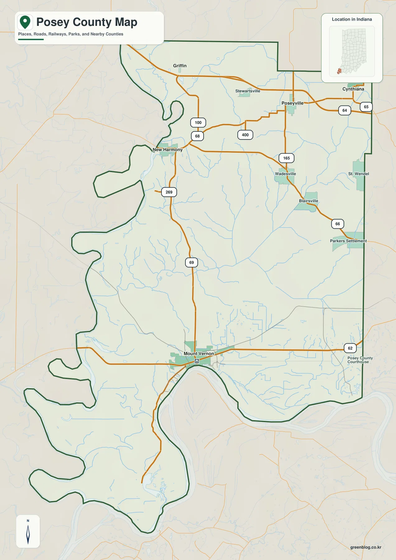
New Harmony occupies a very different setting. It lies near the Wabash River in the northwest, where the county outline bends around the river corridor and the road network is less regular than it is on the eastern side. Roads labeled 68 and 100 appear around the New Harmony and Griffin area, while Poseyville and Cynthiana lie farther east across the north. The Indiana Historical Bureau documents New Harmony’s early nineteenth-century communal experiments, but for map reading its practical role is simpler: it gives the western half of northern Posey County a memorable geographic anchor.
On the east, Wadesville, Blairsville, St. Wendel, and Parkers Settlement add detail between the northern towns and Mount Vernon. Labels such as 165 and 66 make this side easier to place in relation to the county boundary. The map therefore shows a settlement pattern with one clear southern center and several smaller northern or eastern communities separated by large rural spaces. Starting with Mount Vernon, New Harmony, and Poseyville is usually easier than trying to memorize every place name at once.
How Mount Vernon relates to New Harmony and the northern towns
The city-connections map removes much of the road detail and makes Mount Vernon the hub. Its legend states that the connector values are direct distances in miles, not driving mileage. New Harmony is shown about 13 miles from Mount Vernon, Poseyville about 17 miles, Griffin about 19 miles, and Cynthiana about 20 miles. Those numbers are useful for comparing relative spacing, but a road trip can be longer because real routes must follow the available road network, intersections, and river landscape.
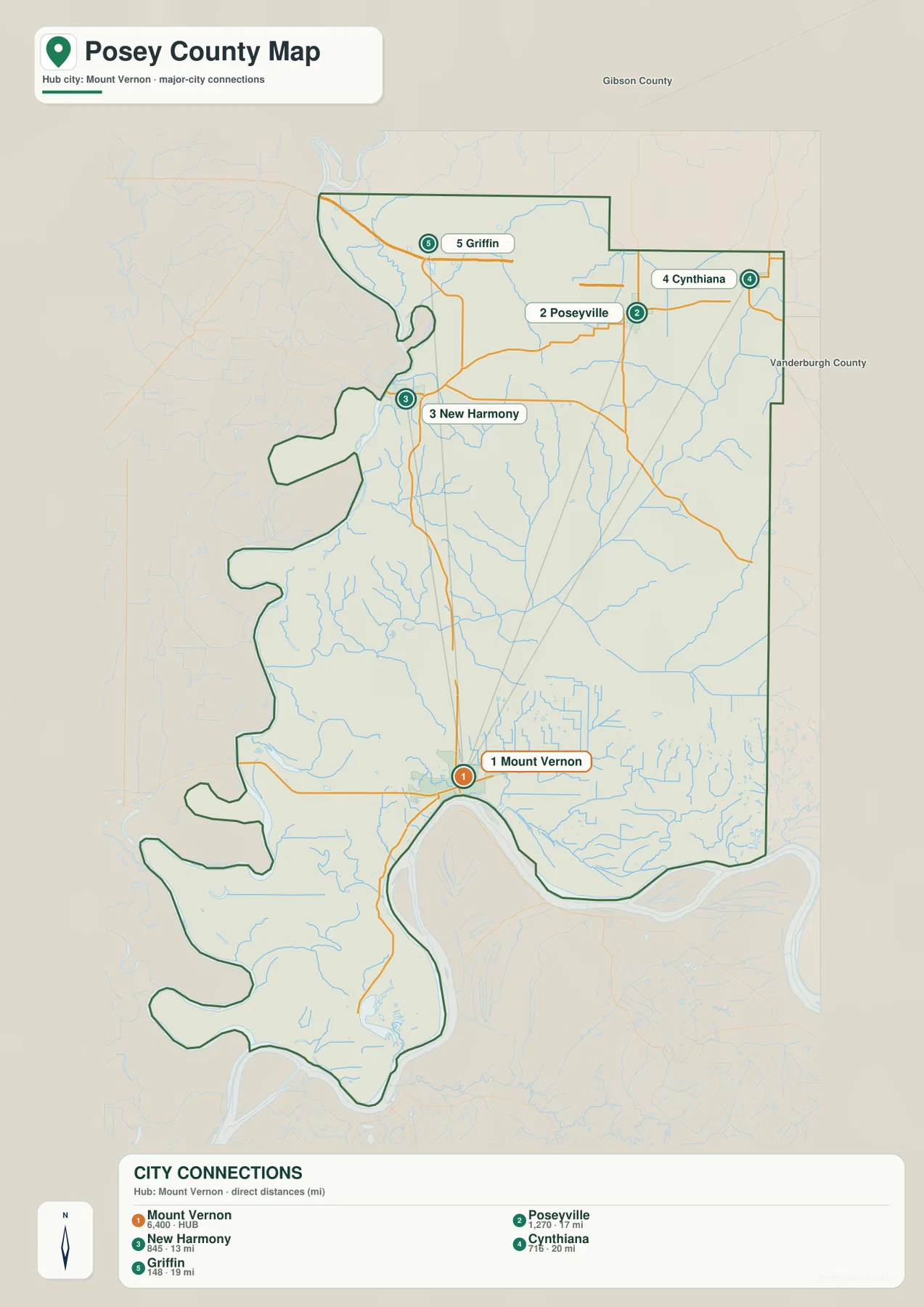
The directions are more important than the exact mileage for understanding the county. New Harmony sits near the Wabash side, Cynthiana approaches the northeastern edge, Poseyville is north and slightly east of Mount Vernon, and Griffin lies farther west across the northern tier. None of these places forms a continuous urban strip with Mount Vernon. Instead, Posey County has a pronounced southern center and a set of smaller communities distributed across the north and northwest.
The map also prints reference values beside the five settlements. Because those numbers are embedded in a static map rather than presented as a continuously updated population table, they should be treated as map-era context rather than as a claim about the latest census count. The more durable information is geographic: the settlements are widely spaced, and their positions provide a framework for comparing the water and terrain maps. Once the town locations are familiar, Black River, Big Creek, Hovey Lake, and the higher eastern ridges can be placed much more quickly.
Creeks, lakes, and sloughs inside the Wabash–Ohio lowlands
The Wabash and Ohio rivers define the outside of Posey County, but the interior water network is also extensive. Black River crosses the northern portion, while Harmonie Creek drains toward the Wabash near New Harmony. Big Creek runs across the middle and gathers smaller tributaries from both sides. Farther east, the map labels additional channels such as Little Creek and Well Creek. Following these named waterways first makes the denser pattern of smaller blue lines much easier to understand.
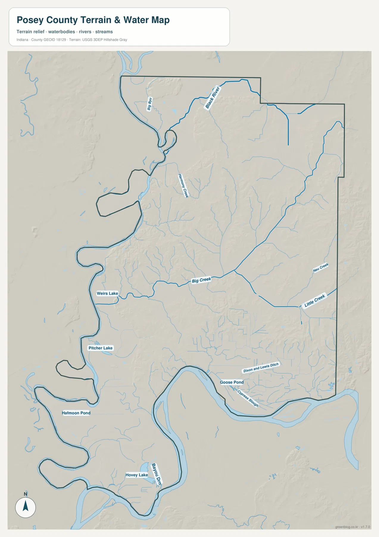
Named water bodies become more noticeable toward the west and southwest. Weirs Lake and Pitcher Lake are shown near the Wabash side, while Halfmoon Pond and Hovey Lake appear farther south. The lower part of the map also labels Goose Pond and Cypress Slough near the Ohio River lowlands. This clustering is useful because it can be compared directly with the elevation map: many of the more conspicuous lakes, ponds, and sloughs occur in areas that are also colored as lower ground.
Hovey Lake is the clearest county-specific example. Indiana DNR describes Hovey Lake Fish & Wildlife Area as a roughly 7,404-acre property within the Ohio and Wabash river floodplains. The agency says it includes an approximately 1,400-acre oxbow lake, smaller sloughs and marshes, and bottomland hardwood forest. That description helps explain why the southwestern corner looks especially wet and low on the supplied maps. It also shows why the water map and the elevation map are more informative when read together than when either is used alone.
Near New Harmony, Harmonie State Park offers another connection between a named place and the mapped river landscape. Indiana DNR describes the park as a wooded area with ravines and trails along the Wabash River. The nearby Harmonie Creek and smaller tributaries visible on the water map fit that northwest drainage setting. The supplied map is still a county overview, not a flood-hazard product, legal water-boundary map, parcel map, or navigation chart. Current agency sources should be used for those decisions.
Low river margins and higher interior ridges
The elevation legend shows an actual range of about 101 to 179 meters and a mean of 124 meters. Green shades dominate the western margin beside the Wabash and continue along much of the southern Ohio River side. The broad southwestern projections of the county, including the Hovey Lake area, are especially low. Around Mount Vernon, the river side remains low while higher colors begin to appear inland to the north. This transition is easier to recognize after locating the same places on the general county map.
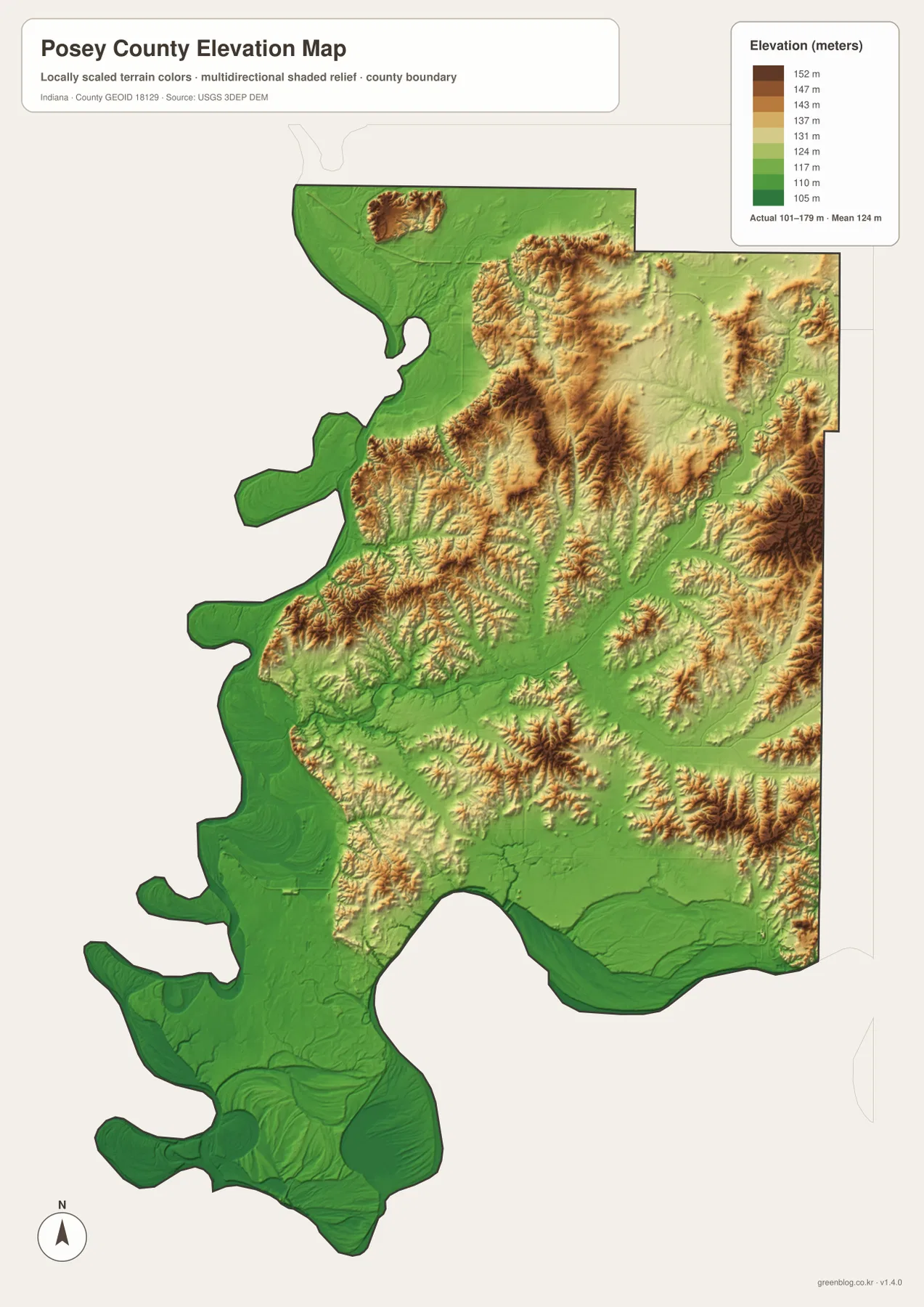
The higher terrain is not one continuous plateau. North-central Posey County contains elongated ridges with lower stream valleys between them, and the eastern side shows additional rolling high ground near and south of Cynthiana. Small higher areas also appear in the central-western interior, but they drop quickly toward the Wabash floodplain. The result is an alternating pattern of low river margins, branching valleys, and upland ridges rather than a simple slope from north to south.
New Harmony provides a useful comparison point because it lies close to the low Wabash corridor, while higher terrain becomes more common to its east. Mount Vernon shows a similar relationship at the southern edge: the immediate Ohio River side is low, but the land rises inland. These colors are generalized for county-scale comparison. They should not be used as a substitute for a property survey, construction elevation, engineering design surface, or other site-specific measurement. USGS 3D Elevation Program data or professional survey information is the better source for precise elevations.
Choosing the right map for roads, water, terrain, or print
For place names, numbered roads, and the overall county outline, start with the general map. It makes the relationship between Mount Vernon, New Harmony, Poseyville, Griffin, Cynthiana, and the smaller eastern communities the easiest to see. It is also the quickest way to recognize why the west and south boundaries look so irregular compared with the north and east: the river edges control much of the county’s outline.
Use the city-connections map when the main question is relative direction or spacing between Mount Vernon and the northern settlements. Use the terrain-and-water map when you want to trace Black River, Big Creek, Harmonie Creek, Hovey Lake, Weirs Lake, Pitcher Lake, and the smaller southern wetlands. If the water map shows a broad wet or low-lying area, compare the same location on the elevation map to see whether it is part of the river lowlands or bordered by higher ridges.
The WebP previews are sized for convenient reading in a browser. For larger road labels, closer inspection of water names and elevation colors, or printing, use the download below. The ZIP contains the high-resolution JPG originals of the general county map, city-connections map, terrain-and-water map, and elevation map, with each image measuring 2572 by 3638 pixels. Downloading the originals avoids the loss of detail that comes from taking a screenshot of the on-page preview.
Frequently Asked Questions
Why is the western and southern boundary of Posey County so irregular?
The Wabash River forms the western side and the Ohio River follows the south, so the county boundary bends with large river curves. The north and east sides are much more regular, which makes the river-shaped west and southwest stand out clearly on the general map.
Is the 13-mile Mount Vernon–New Harmony figure a driving distance?
No. The city-connections map labels direct, straight-line distances. It shows New Harmony at about 13 miles, Poseyville at about 17 miles, Griffin at about 19 miles, and Cynthiana at about 20 miles from Mount Vernon. Actual road mileage can be longer depending on the route.
Where is the clearest contrast between low and high ground?
The broad Wabash and Ohio river margins, including the Hovey Lake area, are among the lowest parts of the map. Higher tan and brown ridges appear more often in the north-central and eastern interior. The elevation legend gives an actual range of about 101–179 meters and a mean of 124 meters.
Map File Information
This ZIP contains the high-resolution JPG originals for the Posey County general map, city-connections map, terrain-and-water map, and elevation map. Use the originals when you need larger road labels, place names, waterways, terrain colors, or print output.
- Printable Size: 2572×3638 px each
Related Maps
Sources and References
The county-specific descriptions above use the supplied maps together with the official sources listed below. Consult the agencies directly when you need current administrative information, detailed hydrography, or source elevation data.
- Posey County Government – Our County – county location, Mount Vernon and New Harmony, and the Wabash/Ohio river borders
- Indiana DNR – Hovey Lake Fish & Wildlife Area – Hovey Lake and the Wabash/Ohio floodplain setting
- Indiana DNR – Harmonie State Park – the Wabash River landscape near New Harmony
- Indiana Historical Bureau – New Harmony – county-specific historical context for New Harmony
- U.S. Census Bureau TIGER/Line Shapefiles – boundary, road, and place reference data
- USGS National Hydrography / USGS 3D Elevation Program – hydrography and source elevation data
Green Map creates custom-edited map images using open geographic data sources such as geoBoundaries, Natural Earth, OpenStreetMap, and government open data.
These maps are edited visual materials, not raw data files, and are provided for education, documents, presentations, and graphic reference.