Gates County sits in the far northeastern corner of North Carolina, where a state line, small communities, major highways, millpond wetlands, and a dense network of creeks are more useful for orientation than a large urban skyline. This page brings those pieces together without treating the county like a metropolitan road map. You can locate Gatesville and Sunbury, follow US 13 and US 158 across the county, compare NC 32, NC 37, and NC 137, and then switch to the water map for Merchants Millpond and nearby creeks. The maps shown in the article are web previews; the corresponding high-resolution A3 JPG files are available together in the download box farther down the page.
That combination matters in Gates County because settlement is sparse. U.S. Census Bureau QuickFacts lists about 340.6 square miles of land and a 2025 population estimate a little above 10,000. The 2020 population density was only 30.8 people per square mile. On a countywide map, that produces a very different visual pattern from a suburban county: roads stretch through broad areas with few large place labels, while streams, swamps, and the county boundary remain prominent reference points. The county government describes Gates County as part of North Carolina’s Inner Banks, and Merchants Millpond State Park is one of its best-known geographic landmarks.
Table of Contents
A North Carolina county shaped by the Virginia line and nearby lowlands
The northern edge of Gates County is also the North Carolina–Virginia state line. Census geography identifies Southampton County and the independent city of Suffolk on the Virginia side, while Hertford, Chowan, Perquimans, Pasquotank, and Camden counties surround Gates County within North Carolina. That makes the north side of the map different from an ordinary county-to-county border: crossing it means entering another state. The eastern and southern sides, by contrast, lead deeper into northeastern North Carolina and toward the Albemarle region.
The county outline is easy to recognize once a few anchors are in place. Its long northern boundary is relatively straight, while the western and southwestern edges bend around broad waterways. The eastern side angles through the lowland landscape rather than forming one simple rectangle. Gatesville lies west of the county’s midpoint and closer to the southwestern side, while Sunbury is farther east. If you find those two labels first and then follow US 158 between the western and eastern parts of the county, the rest of the map becomes much easier to understand.
Gates County’s Inner Banks setting also explains why wetlands and slow-moving water appear so often on the water map. This is not a mountain county where elevation dominates the view. The most useful physical references are lowland creeks, swamps, ponds, and larger river corridors. The three map files therefore separate general county orientation, the simplified city index, and water features instead of forcing all of those labels into one crowded sheet.
Gatesville, Sunbury, and the road pattern across the county
The general county map is the most versatile sheet because it places settlements, highways, local water lines, and the county boundary in one view. Gatesville is the first label to find. From there, Sunbury sits to the east, close to the east-west route of US 158. US 13 enters from the northwest and provides another strong directional reference. Near Sunbury, NC 32 runs north and south, while NC 37 extends toward the southern part of the county. NC 137 is labeled near the Gatesville area and helps distinguish local movement around the county seat from the broader US highway routes.
These roads should be read as orientation lines rather than turn-by-turn driving instructions. The map intentionally leaves out many minor roads so the main pattern stays clear at A3 size and in a smaller web preview. Following US 158 from west to east is especially useful because it carries the eye across the middle of the county toward Sunbury and the eastern boundary. US 13 gives the northwest corner a separate connection, while NC 32 and NC 37 show north-south movement in different parts of the county.
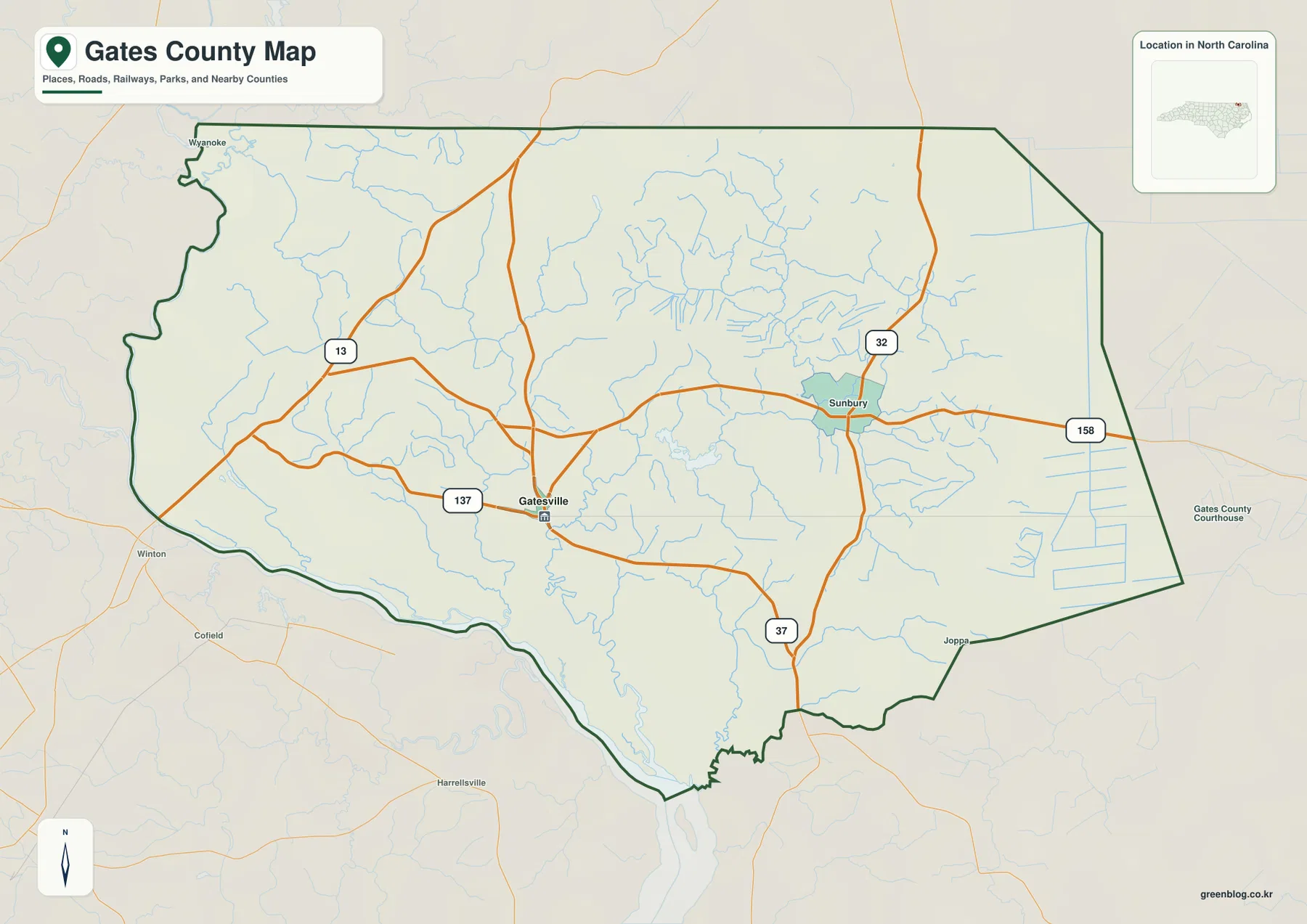
Several labels outside the dark green county outline are included for context. Winton and Cofield appear west of Gates County, and other nearby names help show where the map continues beyond the county line. They should not be mistaken for Gates County communities simply because they are visible on the same sheet. The inset in the upper-right corner also places the county within North Carolina, which is helpful for readers who know the state’s coast and Piedmont better than the Inner Banks.
For a road-focused project, the general map works best as a starting layer rather than a substitute for official transportation records. The North Carolina Department of Transportation publishes a detailed Gates County map with many more road numbers and local routes. Use the downloadable Green Map version when you need a clean county overview for a report, classroom handout, slide, or regional comparison, and use the NCDOT sheet when the exact local road network is the main subject.
Why the city index centers on Gatesville instead of a long town list
The city map is deliberately simpler. In this version, Gatesville is the single ranked major-place label in the county index. The surrounding county names remain visible so the reader can see how the county seat sits between Hertford and Chowan counties to the west and southwest and the eastern counties toward Pasquotank, Camden, and Perquimans. This design is useful when a dense set of community labels would distract from the basic question: where is the county’s administrative center within the larger northeastern North Carolina region?
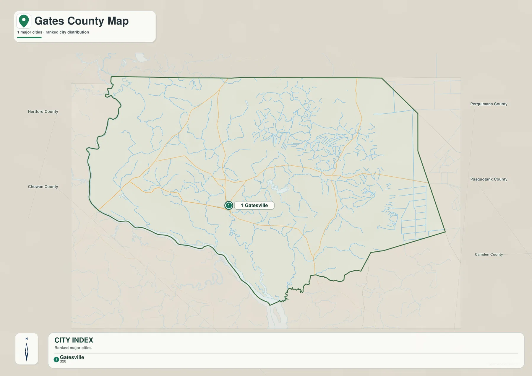
The absence of a large Sunbury marker on this sheet does not mean Sunbury disappears from the county’s geography. It appears on the general county map and remains an important eastern reference point. The city index simply has a narrower job. It is closer to a locator map than a complete gazetteer, so it works well on introductory slides, county fact sheets, or documents where Gatesville needs to be identified quickly without the visual weight of every road and stream.
This simplified view also matches the county’s low-density settlement pattern. With a 2020 population density of 30.8 people per square mile, Gates County does not produce the clustered city labels common in more urban parts of North Carolina. A large portion of the map remains open between the county seat, smaller communities, wetlands, forested areas, and farm country. For readers unfamiliar with the region, that open space is useful information rather than a missing-data problem.
A practical way to use the city index is to begin here, identify Gatesville, and then move to the other maps only when more detail is needed. The general county map adds highways and Sunbury. The water map adds Merchants Millpond, Bennetts Creek, swamps, ponds, and other drainage features. Keeping those functions separate makes each sheet easier to read and reduces the temptation to treat one map as if it were designed for every task.
Merchants Millpond, Bennetts Creek, and a web of swamps and small streams
The water map changes the character of the county completely. Instead of focusing on highway shields and settlement labels, it brings forward Merchants Millpond and a fine network of creeks, branches, swamps, ponds, and ditches. Bennetts Creek is a key name south of the millpond, and Beaverdam Creek appears farther north. Duke Swamp, Reynolds Swamp, Jones Pond, and several smaller named channels show how much of the eastern and central county can be described through water features rather than towns.
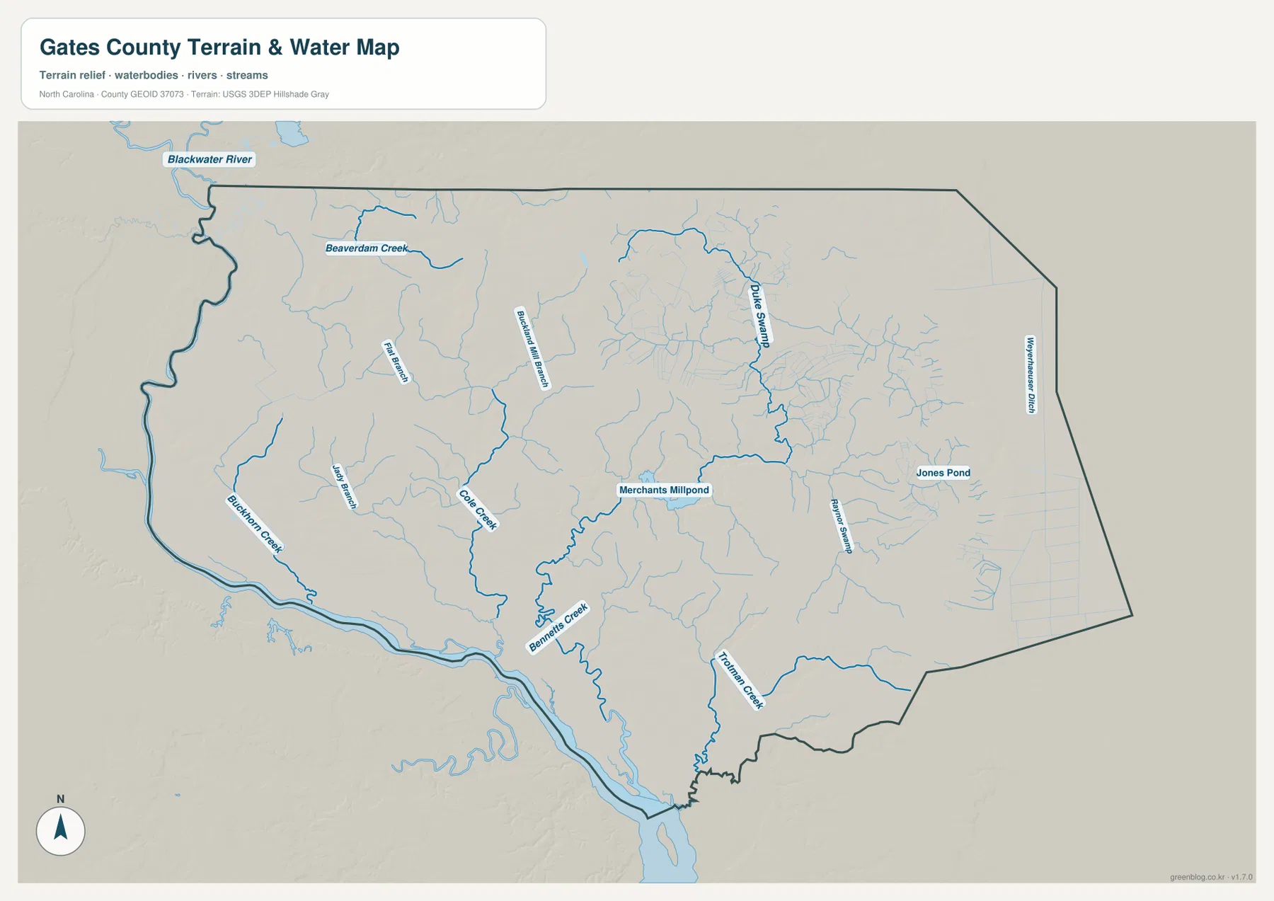
Merchants Millpond deserves special attention because it is both a mapped water feature and one of the county’s best-known public natural areas. North Carolina State Parks describes the park as being in Gates County about 10 miles south of the Virginia border and centered on a roughly 760-acre historic millpond. The park’s wetland landscape includes shallow water, cypress trees, and Lassiter Swamp, while Bennetts Creek is part of its trail and paddling setting. On the county water map, the millpond becomes a strong anchor for understanding the eastern interior rather than just a recreational destination name.
The upper-left edge of the water map also shows the Blackwater River outside the main county outline, giving additional context for the regional drainage network toward Virginia. Along the western and southwestern side, a broad river corridor marks the watery edge of the county, while many smaller channels feed through the interior. The older county article and local geography use the Chowan River as an important western and southwestern reference, and the water map helps place smaller creeks in relation to that larger system.
This sheet is a water-reference map, not a flood insurance map, navigation chart, parcel survey, or legal water-boundary document. It can show where named waterways are located and where wet areas are concentrated, but it does not tell you whether a property floods, whether a channel is navigable, or exactly where a legal boundary falls on the ground. For those questions, use the appropriate official flood, parcel, survey, or navigation source. The subtle terrain shading in the background is also only contextual; a separate elevation map is not part of this package.
Reading Gates County together with its neighboring counties
Gates County becomes easier to place when the neighboring counties are treated as part of the explanation instead of empty margins. Hertford County is to the west, Chowan County is toward the southwest, and Pasquotank, Camden, and Perquimans counties frame the eastern and southeastern side. To the north, the map transitions into Virginia rather than another North Carolina county. That mix gives the county a borderland position between the Inner Banks and the Hampton Roads side of southeastern Virginia.
This regional position helps explain why different readers may approach the map from different directions. Someone coming from Winton or Hertford County will naturally use the western roads and river edge as reference points. A reader approaching from the Elizabeth City side is more likely to notice US 158 and the eastern county line. A park visitor may care most about Gatesville, Merchants Millpond, and Bennetts Creek. None of those viewpoints requires a different county outline, but each benefits from a different map layer.
For classroom or research use, a concise description can combine these relationships without becoming technical: Gates County lies on North Carolina’s Virginia border, Gatesville is the county seat, US 158 provides a strong east-west reference, and Merchants Millpond anchors the county’s wetland geography. That sentence gives a reader four useful anchors before they ever study the smaller labels. If more precise demographic, transportation, or hydrographic information is needed, the source links at the end of the article lead to the agencies responsible for those datasets.
Choosing the right file for print, classwork, or local reference
Start with the boundary and road map when you need the broadest county overview. It is the best choice for showing Gatesville, Sunbury, the major highways, nearby places, and the county outline on one page. Choose the city index when the county seat should stand out with minimal clutter. Use the water map when the subject is Merchants Millpond, Bennetts Creek, swamps, ponds, or the wider network of small waterways that gives the county much of its physical character.
The downloadable archive contains three A3 high-resolution JPG files that correspond to those three body maps. The WebP images in the article are optimized for quicker browsing, while the larger JPG files are better suited to inserting into documents, presentations, classroom materials, and other projects that benefit from higher resolution. Keep the original aspect ratio when resizing for print so place labels, road shields, and boundary lines do not become stretched.
- County map: best for boundary, Gatesville, Sunbury, major roads, and general county orientation.
- City map: best for a clean Gatesville locator with neighboring county context.
- Water map: best for Merchants Millpond, Bennetts Creek, swamps, ponds, and stream locations.
Frequently Asked Questions
Which map is best for comparing Gatesville, Sunbury, and the main highways?
Use the general county map. Gatesville is labeled west of the county’s midpoint, Sunbury is farther east, and US 158 provides a strong line for comparing the two parts of the county. US 13, NC 32, NC 37, and NC 137 add useful directional references. The sheet is designed for countywide orientation, so use an official road map or navigation service if you need individual local streets or turn-by-turn directions.
Why is Merchants Millpond such a useful landmark on a Gates County map?
Merchants Millpond is both a distinctive water feature and the centerpiece of a North Carolina state park in Gates County. Its connection with Bennetts Creek and nearby swamps makes it a practical anchor for explaining the county’s wetland geography. On the water map, it is easier to see how the pond fits into a wider network of streams and low-lying wet areas than it would be on a simple road map.
What is included in the Gates County map download?
The archive includes three high-resolution A3 JPG files: the general county map, the city index map, and the terrain-and-water reference map. The package does not include a separate elevation map or land-cover map, so those map types are not listed in the download box. The JPG files correspond to the WebP previews used in the article and are the better option for printing or placing in larger documents.
Sources and Reference Data
- Gates County Government – About the County — used for the county’s Inner Banks context and local profile.
- North Carolina State Parks – Merchants Millpond State Park — used for the millpond location, size, and wetland setting.
- U.S. Census Bureau QuickFacts – Gates County — used for land area, population, and density context.
- North Carolina Department of Transportation – Gates County Map — used to cross-check the county’s highway network.
- USGS National Hydrography — official reference for hydrographic data and water-feature context.
Map File Information
The ZIP contains the three A3 high-resolution JPG maps that correspond to the county, city, and water previews shown on this page.
- Included Files: county map, city map, water map
- File Type: JPG
Related Maps
Green Map creates custom-edited map images using open geographic data sources such as geoBoundaries, Natural Earth, OpenStreetMap, and government open data.
These maps are edited visual materials, not raw data files, and are provided for education, documents, presentations, and graphic reference.