Loudon County sits in East Tennessee where major highways, river valleys, reservoirs, and narrow ridges share a relatively compact county. The supplied maps make that mixture easy to see: Lenoir City anchors the north, Loudon sits farther south near the middle, Greenback lies toward the southeast, and Philadelphia marks the southwestern side. The road map also places I-40 and I-75 in the northern part of the county while the Tennessee River and its connected lakes cut broad curves through the center and east.
Four map views are provided on this page: a county reference map, a city-connections map, a terrain-and-water map, and an elevation map. Each appears as a WebP preview in the article, while the download box provides the matching four high-resolution A3 JPG files in one ZIP. The sections below focus on the details that are actually visible in these files, including the Lenoir City–Loudon relationship, straight-line city distances, the Tennessee River and Tellico Lake system, and the 220–399 meter elevation range shown on the elevation graphic.
Table of Contents
Northern highways lead into the Lenoir City–Loudon corridor
The general county map is most useful when you begin in the north. Lenoir City is prominently labeled near the cluster of major roads, and Loudon appears farther south as the county seat. I-40 and I-75 are both emphasized in the northern part of the map, with US 70 and US 11 nearby. US 321 provides another strong reference on the eastern side. Once those roads are located, the smaller state-route numbers and local streets are much easier to place without turning the map into a list of route shields.
Loudon and Lenoir City do not occupy the same part of the county or serve the same map-reading purpose. Loudon is the administrative seat, while Lenoir City is the northern urban reference and the hub selected by the city-connections map. Philadelphia lies southwest of Loudon, while Greenback is near the southeastern edge. Together, those four labels give the county a clear north-to-south and west-to-east frame before you start tracing rivers or minor roads.
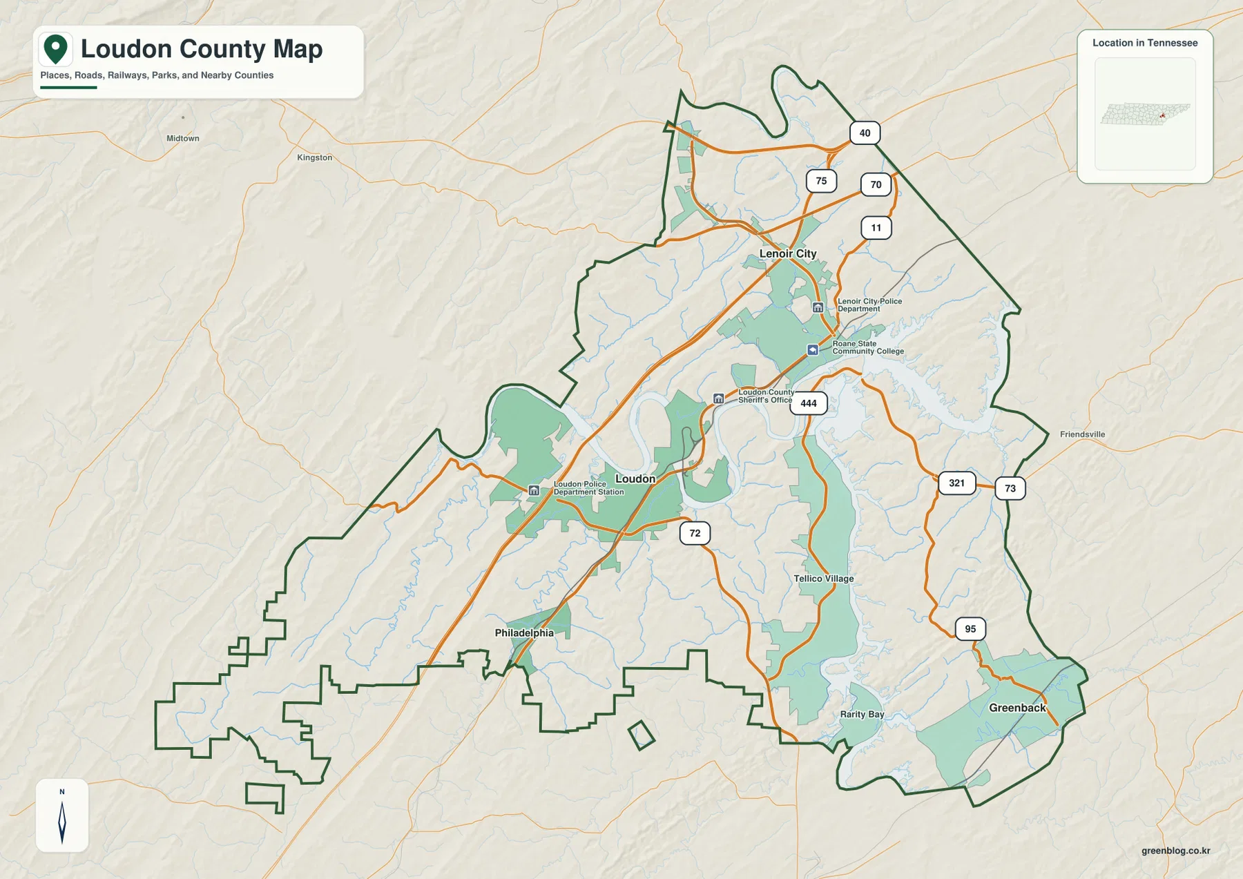
The outline itself is worth noticing. Loudon County has an extended southwestern section and a curving eastern side rather than a simple rectangular shape. The supplied county information identifies Knox, Blount, Monroe, McMinn, and Roane counties as neighboring jurisdictions. Labels such as Kingston, Midtown, and Friendsville appear beyond the county line on the reference map, which is a useful reminder to check the boundary before assigning an edge road or place name to Loudon County.
The existing county material states that Loudon County was established in 1870 and that Loudon is the county seat. That historical fact helps explain why the seat and the larger northern city should not be treated as interchangeable labels. For a quick orientation, use Loudon when you need the government center, then shift to Lenoir City when you want to understand the northern highway network and the city map’s connection lines.
The city map measures outward from Lenoir City, not from the county seat
The city-connections graphic deliberately simplifies the county. It ranks Lenoir City first and uses it as the hub, with Loudon second, Greenback third, and Philadelphia fourth. The index printed along the bottom shows 11,110 for Lenoir City, 6,432 for Loudon, 1,378 for Greenback, and 684 for Philadelphia. Because the image does not state a reference year for those figures, they are best treated as the values used to order this particular city graphic rather than as a claim about the latest municipal population.
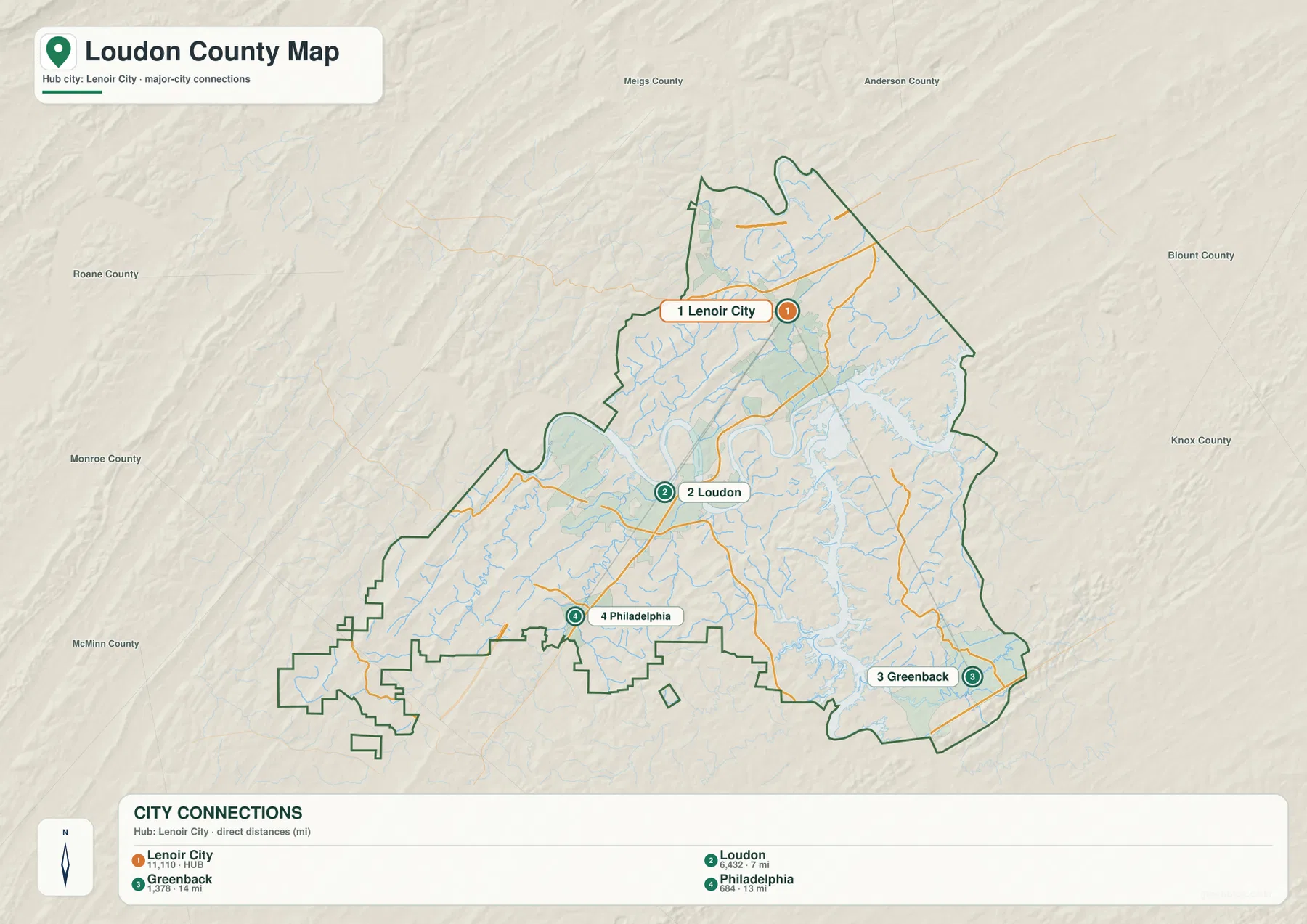
The distance labels are explicitly described as direct distances in miles. Loudon is 7 miles from the Lenoir City hub, Philadelphia 13 miles, and Greenback 14 miles. Those are straight-line comparisons, not driving distances. A road trip can be longer because the Tennessee River, reservoir arms, bridge locations, and the shape of the road network determine how a vehicle actually moves between the same places.
Direction matters as much as the numbers. Loudon is south of Lenoir City, Philadelphia is farther to the southwest, and Greenback is southeast near the county edge. This layout makes the city map useful for teaching or quick geographic orientation because the viewer can separate city spacing from road routing. The county reference map can then be used to add I-75, US 321, and the smaller routes after the basic city positions are understood.
The Tennessee River and reservoir arms occupy the visual center of the county
Water is not a minor background feature in these maps. The terrain-and-water view shows the Tennessee River making broad bends across the north-central and central part of the county, with Watts Bar Lake labeled where the water widens toward the east. The river’s shape immediately explains why a simple straight line between two nearby points may not resemble the available road route.
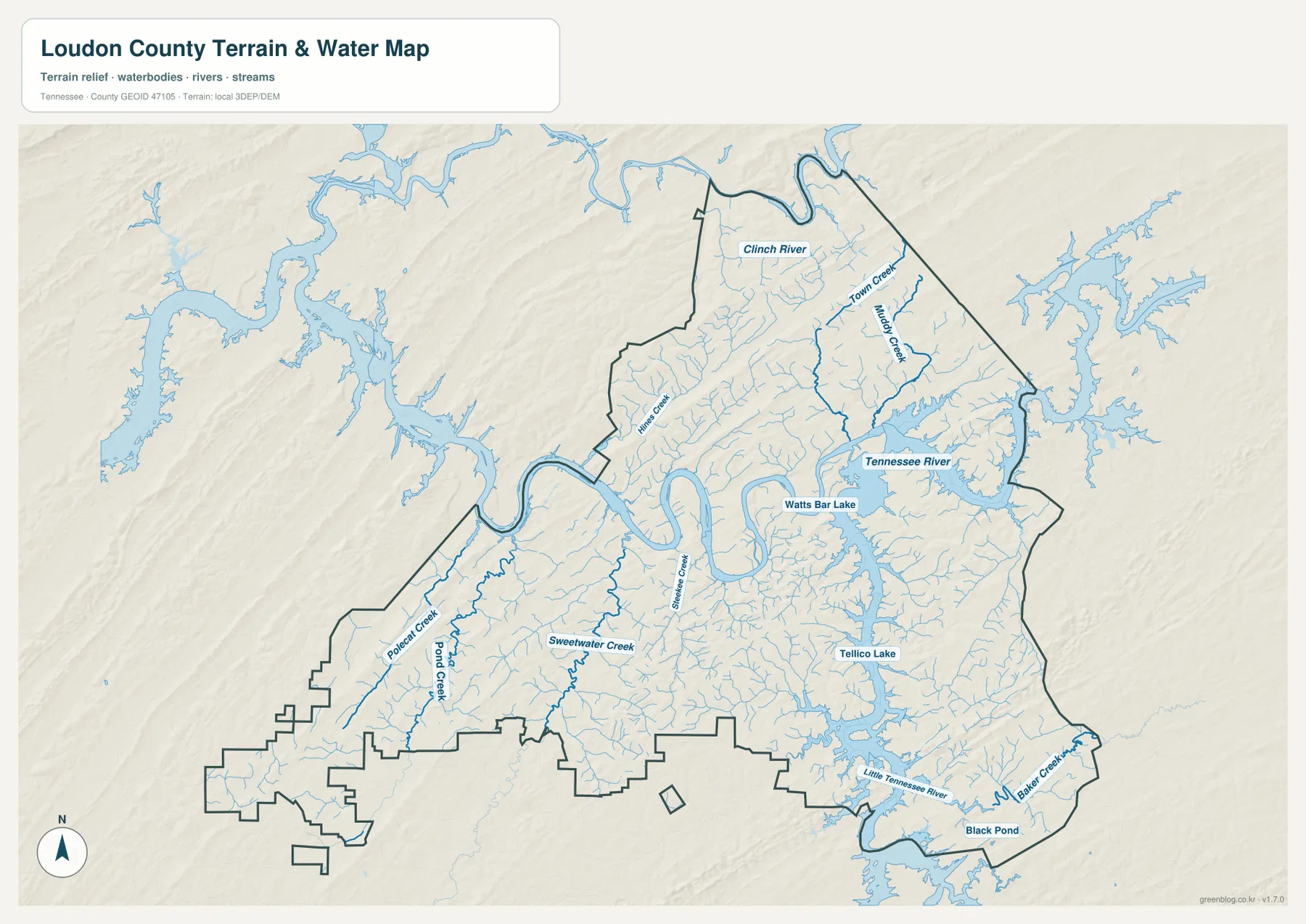
The southeastern half has a different water pattern. Tellico Lake forms a long, branched body of water through the eastern and southern part of the county, and the Little Tennessee River is labeled near the southern edge. Baker Creek and Black Pond are also marked near the southeast. Rather than reading Tellico Lake as a single compact lake, the map shows why its many arms can create long shorelines and narrow land corridors.
Several named creeks help fill in the smaller drainage network. Town Creek and Muddy Creek appear in the north, while Hines Creek is labeled farther west. Polecat Creek, Pond Creek, and Sweetwater Creek cross the southwestern side, and Steekee Creek runs through the central portion. The Clinch River is labeled near the northern edge. Many thinner unnamed channels branch between those features, so the map is more informative when read from the large rivers and lakes outward to the smaller streams.
The supplied county facts list 18.1 square miles of water, compared with 229.3 square miles of land. That countywide figure matches the visual importance of the reservoirs and river bends, but it should not be used to infer current water level, flood exposure, or boating access at a specific location. This is a reference map for the arrangement of water features. Current flood information, navigation restrictions, and shoreline conditions require more specialized and up-to-date sources.
Elevation follows the river valleys while narrow ridges rise between them
The elevation map gives an actual range of approximately 220 to 399 meters and a mean elevation of 279 meters. Green tones represent the lower parts of the county, while yellow and brown indicate progressively higher ground. The lowest colors are concentrated around the Tennessee River and the large lake arms, and narrow green valleys extend away from those waters into the surrounding terrain.
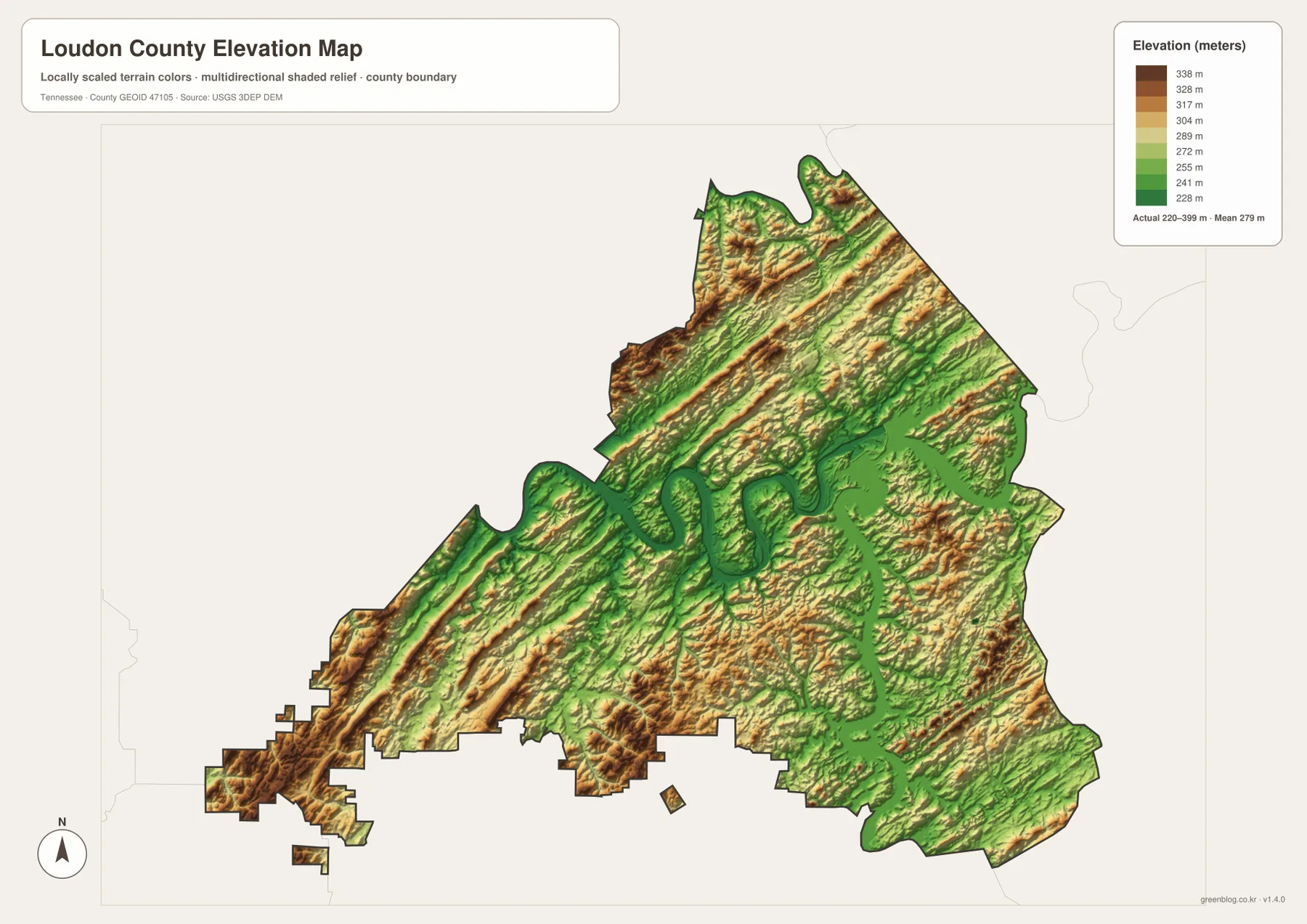
The higher ground is not confined to one corner. Repeated ridge bands appear through the northern portion, along the southwestern extension, and across parts of the east and south. When the elevation graphic is compared with the water map, the pattern becomes easier to interpret: green corridors often follow the main water bodies and creek valleys, while the higher yellow and brown strips remain between those drainages.
This terrain helps explain why the county can look compact on a boundary map yet contain routes that bend and change direction. A point near Lenoir City or Loudon may be separated from another nearby point by a river crossing or a ridge. Around Greenback and Tellico Lake, low shoreline zones sit close to higher ground. The map does not calculate travel time, but it provides useful context for why the transportation map cannot be understood from straight-line distance alone.
Elevation color is not land-cover information. A green area on this graphic means lower elevation, not necessarily forest, wetland, or open space, and brown does not automatically mean wooded land. The generalized surface is also not a survey product for construction or engineering. Use it to compare broad valleys and ridges across the county; use a precise current elevation source or field survey when an exact site measurement is required.
Population and area figures add scale without replacing the map
The supplied county material lists a 2020 census population of 54,886 and a July 2025 estimate of 63,764. Those numbers are from different statistical products and should remain labeled by year and type. They are useful for understanding the overall size of Loudon County, but they do not show how residents are distributed among Lenoir City, Loudon, Greenback, Philadelphia, shoreline communities, and rural ridge areas.
The same caution applies to the countywide area figures. Loudon County is listed with 229.3 square miles of land and 18.1 square miles of water. The water map gives the area number geographic meaning by showing the broad Tennessee River, Watts Bar Lake, and Tellico Lake system, while the elevation map explains why the remaining land is not one level surface. Looking at the numbers and maps together is more useful than turning either one into a stand-alone description of the county.
For a practical workflow, choose the county reference map when you need boundaries, road numbers, towns, and nearby places on one page. Use the city-connections map when the main question is the relative position of Lenoir City, Loudon, Greenback, and Philadelphia. The terrain-and-water map is the clearest choice for rivers, lakes, and named creeks, while the elevation map is best for showing where low valleys and higher ridges occur.
The four views also work well as a matched annotation set. For example, mark Lenoir City and Loudon on the county map, compare their 7-mile direct separation on the city map, find the nearby Tennessee River bends on the water map, and then look at the same corridor on the elevation image. That sequence keeps road, distance, water, and height information separate while still describing the same places.
Frequently Asked Questions
Are the 7, 13, and 14 mile labels on the city map driving distances?
No. The graphic identifies them as direct distances from the Lenoir City hub. Loudon is shown at 7 miles, Philadelphia at 13 miles, and Greenback at 14 miles. Actual driving distance can be longer because roads must follow available crossings and routes around the Tennessee River, reservoirs, and ridges.
Which map is best for finding the Tennessee River and Tellico Lake?
Use the terrain-and-water map first. It clearly labels the Tennessee River, Watts Bar Lake, Tellico Lake, the Little Tennessee River, and several creeks. If you also need city names or highway numbers, compare the same location with the general county map rather than expecting one image to carry every layer.
What is included in the Loudon County download ZIP?
The ZIP contains four high-resolution A3 JPG files matching the county reference map, city-connections map, terrain-and-water map, and elevation map shown in the article. The WebP images in the body are convenient previews; the JPG files are the larger versions intended for download and reuse.
Map File Information
The ZIP contains the Loudon County reference, city-connections, terrain-and-water, and elevation maps as four high-resolution A3 JPG files. Use the JPG set when you need larger images for printing, classroom material, presentations, or local reference work.
- Included Files: 4 high-resolution A3 JPG images
Related Maps
Sources and references
- Tennessee State Library and Archives – Loudon County fact sheet
- Tennessee Department of Transportation – Loudon County functional classification map
- U.S. Census Bureau QuickFacts – Loudon County, Tennessee
- USGS National Hydrography – water data
- USGS 3D Elevation Program – elevation data
Green Map creates custom-edited map images using open geographic data sources such as geoBoundaries, Natural Earth, OpenStreetMap, and government open data. These maps are edited visual materials, not raw data files, and are provided for education, documents, presentations, and graphic reference.