Lincoln County sits along Tennessee’s southern edge, where Fayetteville forms the clearest center for roads, services, and county government while the county stretches north toward Petersburg and south to the Alabama line. The supplied county map makes that pattern easy to recognize: US 64 crosses the Fayetteville area from west to east, US 231 runs through the county from the north, and US 431 continues south toward Park City and the state boundary. Smaller communities, creeks, and numbered routes fill in the spaces between those larger reference points.
This page includes a county reference map, a ranked city map, a waterways map, and an elevation map. The WebP images are intended for on-page viewing, while the map file box later in the article provides a ZIP containing four high-resolution A3 JPG files. Using the maps together is especially helpful in Lincoln County because the settlement pattern, the broad bends of the Elk River, and the contrast between low stream valleys and higher ridges are easier to understand when they are not forced into a single crowded image.
Table of Contents
Fayetteville, the main roads, and the Tennessee–Alabama line
Fayetteville is the county seat and the most prominent place on the general county map. From there, US 64 provides the strongest east–west reference, while US 231 approaches from the north and US 431 runs south. Those three routes establish a useful frame before the smaller route shields are considered. The map also shows Route 129 near Petersburg and several other numbered routes around the western, southern, and southeastern parts of the county, but the major highways are enough to understand the basic orientation.
The outer settlement labels make Lincoln County more than a Fayetteville-centered diagram. Petersburg sits close to the narrow northern extension of the county. Flintville appears in the southeast, Park City is just south of Fayetteville, and Delrose lies to the west. Blanche and Taft provide additional references in the southwest, while Ardmore is marked near the state line. Motlow State Community College is also labeled east of Fayetteville, giving readers another recognizable point along the road network.
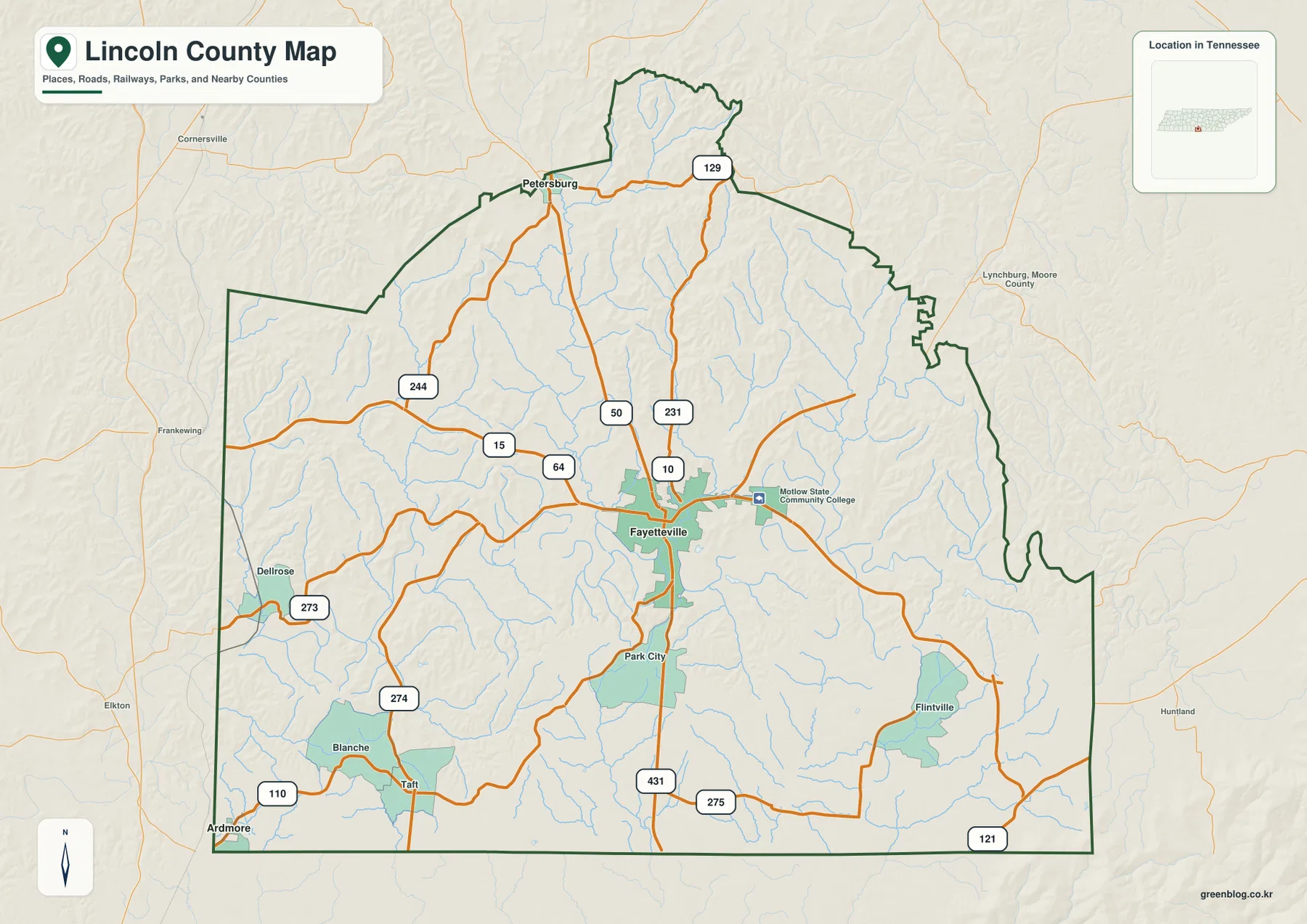
The county’s location matters because its southern edge is also the Tennessee–Alabama state line. The supplied article data identifies Bedford, Moore, Franklin, Giles, and Marshall counties around the Tennessee side, with Madison and Limestone counties in Alabama along the south. On the city map, Marshall, Bedford, Moore, Franklin, and Giles are labeled around Lincoln County, while Coffee County appears farther east. These surrounding names help prevent a place near the edge from being mistaken for a community inside Lincoln County.
The existing county data lists a 2020 census population of 35,319 and a July 2025 estimate of 36,853. It also gives about 570.3 square miles of land and 0.4 square miles of water. Those figures describe the county as a whole rather than the distribution of people within it, but they provide useful scale. Fayetteville is clearly the largest urban reference on the supplied city map, while much of the space between the mapped communities is rural and crossed by smaller roads and streams.
The Elk River’s broad bends and the Flint River system in the southeast
Water is much more prominent once the dedicated waterways map is opened. The Elk River is the dominant feature, bending repeatedly across the middle of Lincoln County from the eastern side toward the west. Its broad meanders are visually different from the narrower tributaries that feed toward the center, making the river a natural reference line for comparing the western, central, and eastern parts of the county.
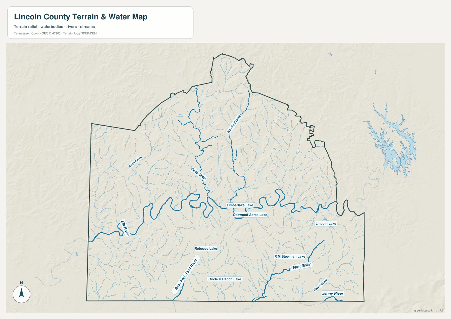
North and west of the Elk River, several named creeks help organize the drainage. Norris Creek runs south through the north-central part of the county, while Cane Creek approaches the Elk River from the northwest side of the central area. Swan Creek is labeled farther west. These waterways are surrounded by many smaller unnamed tributaries, so the map shows a dense branching network rather than a single river with only one or two feeders.
The southern and southeastern part of the county has a different set of names. Barren Fork Flint River enters from the south-central edge, and the Flint River is marked in the southeast. R M Steelman Lake lies near that system, while Hester Creek and Jenny River appear farther toward the southeastern corner. Around the middle of the county, Timberlake Lake and Oakwood Acres Lake sit near the Elk River, and additional small water bodies include Rebecca Lake, Circle H Ranch Lake, and Lincoln Lake.
This map should be used as a county-scale water reference, not as a flood map or a navigation chart. It shows where the named rivers, creeks, and lakes are located in relation to the county boundary, but it does not provide current water levels, bridge conditions, flood zones, or boating access. Its greatest value is in answering location questions: where the Elk River crosses the county, which creeks approach it, and where the separate Flint River drainage appears in the south and southeast.
Low river valleys cut through a much higher ridge landscape
The elevation map adds the vertical dimension that the road and water maps cannot show by themselves. Its legend gives an actual elevation range of about 181 to 455 meters and a mean of about 257 meters for the mapped county. Greens represent lower terrain, while yellow, orange, and brown mark progressively higher ground. The pattern is not a simple north-to-south slope; narrow low valleys repeatedly cut into higher surfaces across much of the county.
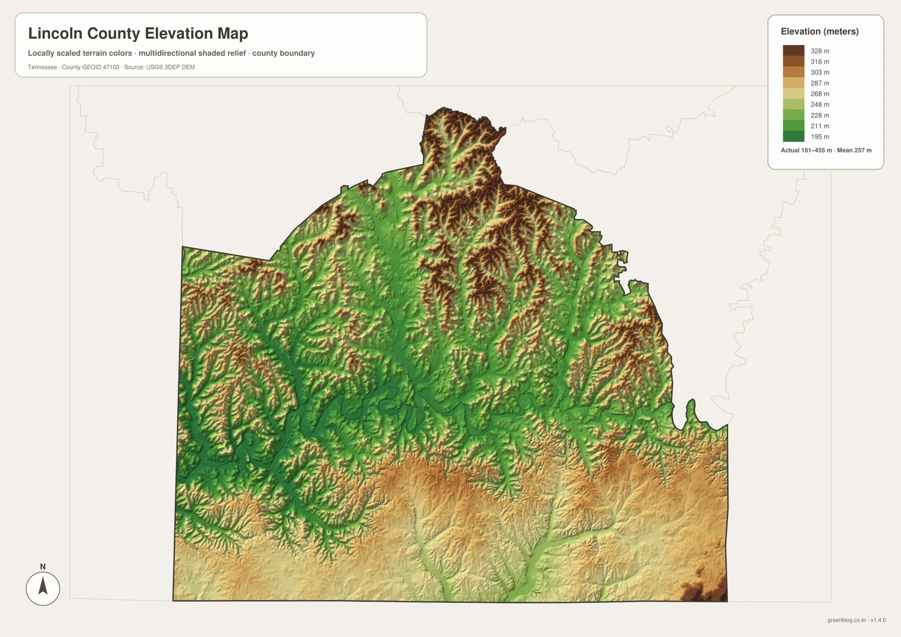
The Elk River corridor is one of the clearest lower areas. When the water and elevation maps are compared, the river’s large bends correspond with a broad green valley through the middle of the county. Smaller green branches extend away from it along creeks such as Norris Creek and Cane Creek. Between those valleys, ridges rise into yellow and brown shades, especially across the northern and northeastern portions of the county.
The southern half is also more varied than a flat plain. Broad areas sit at moderate to higher elevations, but narrow valleys cut through them along the Barren Fork Flint River and the Flint River system. A small area of very high relief appears toward the southeastern edge, while the northern extension contains closely spaced ridges and valleys. The result is a county where streams repeatedly divide higher ground into smaller ridges and uplands.
Elevation colors should not be confused with land cover. A green valley on this map is not automatically wetland, and a brown ridge is not automatically forest. The map is also not survey-grade elevation data for a parcel or construction site. It is a generalized county-scale surface intended to show relative height, valley position, and the way higher and lower terrain connect across Lincoln County.
Why the city map focuses on Fayetteville and Petersburg
The ranked city map deliberately removes much of the detail from the general map. Only Fayetteville and Petersburg are presented as major cities in the index, with Fayetteville ranked first and Petersburg second. The index printed on the map shows values of 7,057 for Fayetteville and 508 for Petersburg. Because the image does not state the date or statistical vintage for those city values, they are best treated as the figures used by this particular map rather than as a claim about the latest population of either place.
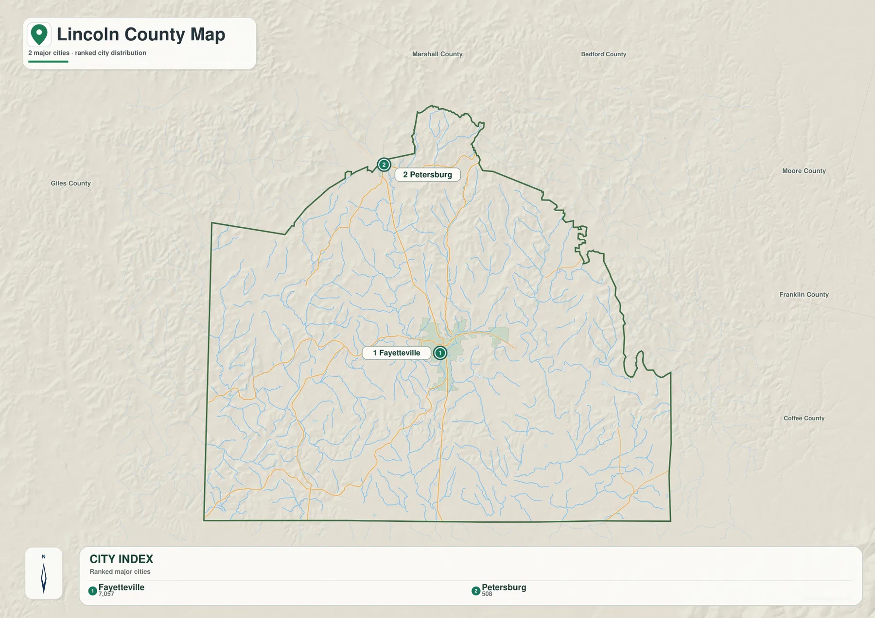
Their positions also tell a geographic story. Fayetteville is near the middle of the county where several major roads meet, while Petersburg is near the northern boundary. The distance between them passes through a long interior area crossed by streams and rural roads. That makes the map useful for showing that Lincoln County is not simply a compact urban area surrounding Fayetteville; the northern portion has its own settlement reference and a noticeably different position relative to the county boundary.
Flintville, Park City, Taft, Blanche, Delrose, and Ardmore remain important on the general map even though they do not appear in the two-place city ranking. Switching between the two maps helps separate two questions: “Where are the principal cities highlighted by the city index?” and “What other named communities help me locate roads and parts of the county?” For a presentation that needs only the strongest settlement references, the city map is cleaner. For route work or local orientation, the county map provides the necessary detail.
Putting the present-day maps beside Lincoln County’s administrative context
The supplied background material states that Lincoln County was established in 1809 and that Fayetteville is the county seat. Those historical facts explain why Fayetteville is the administrative reference, while the maps show how that role sits within the modern pattern of roads, communities, waterways, and relief. The county is therefore easier to understand when the seat is treated as one important layer rather than as the only feature worth mapping.
The population figures also benefit from being separated by date. The 35,319 count comes from the 2020 census, while 36,853 is identified in the supplied material as a July 2025 estimate. The latter is about 4.3 percent higher than the census count, but the two figures are not interchangeable because one is a decennial count and the other is an estimate. If the numbers are added to a printed map, keeping the year beside each value avoids suggesting that both describe the same moment.
A useful map-reading exercise is to follow one place through all four images. Start with Fayetteville on the county map and note US 64, US 231, and US 431. On the city map, compare its central position with Petersburg at the northern edge. Then move to the waterways map and locate the central bends of the Elk River. Finally, use the elevation map to see the lower river valley and the higher ridges surrounding it. The same method works for Flintville in the southeast or for the Taft–Blanche–Ardmore area in the southwest.
Choosing the right Lincoln County file for the job
For boundaries, roads, named communities, and general orientation, the county map is the best starting point. The city map is useful when a simple Fayetteville–Petersburg comparison is all that is needed. The waterways map is the strongest choice for the Elk River, Norris Creek, Cane Creek, the Flint River system, and the small named lakes. The elevation map is designed for comparing valleys, ridges, and relative height rather than for identifying roads or land use.
Printed side by side, the four maps can support classroom work, local history notes, trip planning at a broad scale, or an annotated county reference sheet. One practical approach is to mark Fayetteville and Petersburg first, trace the major highways on the county map, and then use a second color for the Elk River and important tributaries on the waterways map. The elevation map can be used to add a note where a road or community sits in a lower valley versus higher ground.
The maps should remain reference material rather than a substitute for current operational information. Road construction, closures, parcel boundaries, emergency routes, and legal access can change or require more precise data than a static county image provides. For those purposes, the TDOT and other responsible agencies listed in the references are the better sources. The downloadable JPGs are most useful when a clear, high-resolution base map is needed for printing, comparison, or annotation.
Frequently Asked Questions
Why does the city map show only Fayetteville and Petersburg as major cities?
The supplied city map uses a ranked major-city format and includes Fayetteville and Petersburg in that index. Other names such as Flintville, Park City, Taft, Blanche, Delrose, and Ardmore appear on the general county map but are not part of the same city-ranking layer. Use the city map for the simplified two-place comparison and the county map when you need the wider set of local labels.
Which maps should I compare to understand the Elk River valley?
Start with the waterways map to follow the Elk River’s large bends across the middle of the county, then compare the same area on the elevation map. The river corridor appears as lower green terrain, while higher ridges rise between the river and its tributary valleys. Using both maps keeps water names and elevation differences clear instead of forcing them into one crowded view.
What is included in the Lincoln County download ZIP?
The archive contains four high-resolution A3 JPG files matching the supplied county, city, waterways, and elevation maps. The WebP images in the article are optimized for on-page viewing; the JPG files are intended for larger display, printing, and reuse.
Map File Information
The ZIP contains high-resolution A3 JPG versions of the Lincoln County reference map, city map, waterways map, and elevation map. Use these files when you need larger images for printing, classroom material, presentations, or detailed annotation.
- Included Versions: county, city, waterways, elevation
- Included Files: 4 high-resolution A3 JPG maps
Related Maps
- Alamo to Gadsden: A Crockett County Tennessee Map
- Altamont, Monteagle, and Plateau Valleys — Grundy County Tennessee Map
- Around Chattanooga: Hamilton County Tennessee Map
Sources and references
- Tennessee State Library and Archives – Lincoln County fact sheet
- Tennessee Department of Transportation – Lincoln County functional classification map
- U.S. Census Bureau QuickFacts – Lincoln County, Tennessee
- USGS National Hydrography
- USGS 3D Elevation Program
Green Map creates custom-edited map images using open geographic data sources such as geoBoundaries, Natural Earth, OpenStreetMap, and government open data. These maps are edited visual materials, not raw data files, and are provided for education, documents, presentations, and graphic reference.