You can download four high-resolution A3 JPG maps of Knox County, Texas in one ZIP directly from this page. The maps show Benjamin, Munday, Knox City, Goree, U.S. 82 and U.S. 277, the South and North Wichita rivers, the Brazos River, several named lakes and creeks, and an elevation range of about 362 to 545 meters. The general map is the best starting point for roads and communities, while the city-connections, water, and elevation views add information that is difficult to see on a single crowded map.
The county has a useful visual contrast. Benjamin sits near the middle-west portion of the road network, Munday and Knox City anchor the south, and the northern boundary follows an irregular river-shaped line rather than a simple straight edge. The western and northwestern terrain is visibly higher on the elevation map, while lower green corridors become more common toward the east and along major rivers. Because each supplied map uses the same county boundary, the reader can move from a road location to a water feature or elevation zone without having to reorient the entire page.
Table of Contents
Benjamin and U.S. 82 provide the easiest starting point
Benjamin is the clearest reference point on the general county map. It lies a little west of the county’s center and sits directly along U.S. 82, which runs across the county from west to east. East of Benjamin, the map also labels 114 along the same broad corridor before U.S. 82 continues beyond the county. A north-south road leaves the Benjamin area toward the southern communities, so once Benjamin is located, much of the rest of the road pattern becomes easier to follow.
Munday stands in the southeast portion of the county and is connected to several numbered roads. Route 222 runs across the southern part of the map toward Munday, U.S. 277 heads south from the town, and 357 continues eastward. Knox City is near the southern boundary to the west of Munday, while 143 appears near the southwestern side of the county. Rather than treating these road numbers as a list, it is more useful to see how Benjamin, Knox City, and Munday form three separate reference points for the central and southern parts of the county.
The map also labels places beyond the county boundary, including O’Brien, Rochester, and Weinert to the south. These names are helpful for orientation, but the main Knox County comparison should stay with the communities inside the boundary. Benjamin, Munday, and Knox City reappear in the other supplied maps and therefore work better as consistent landmarks when switching between roads, waterways, and relief.
The city-connections map uses Munday as its hub
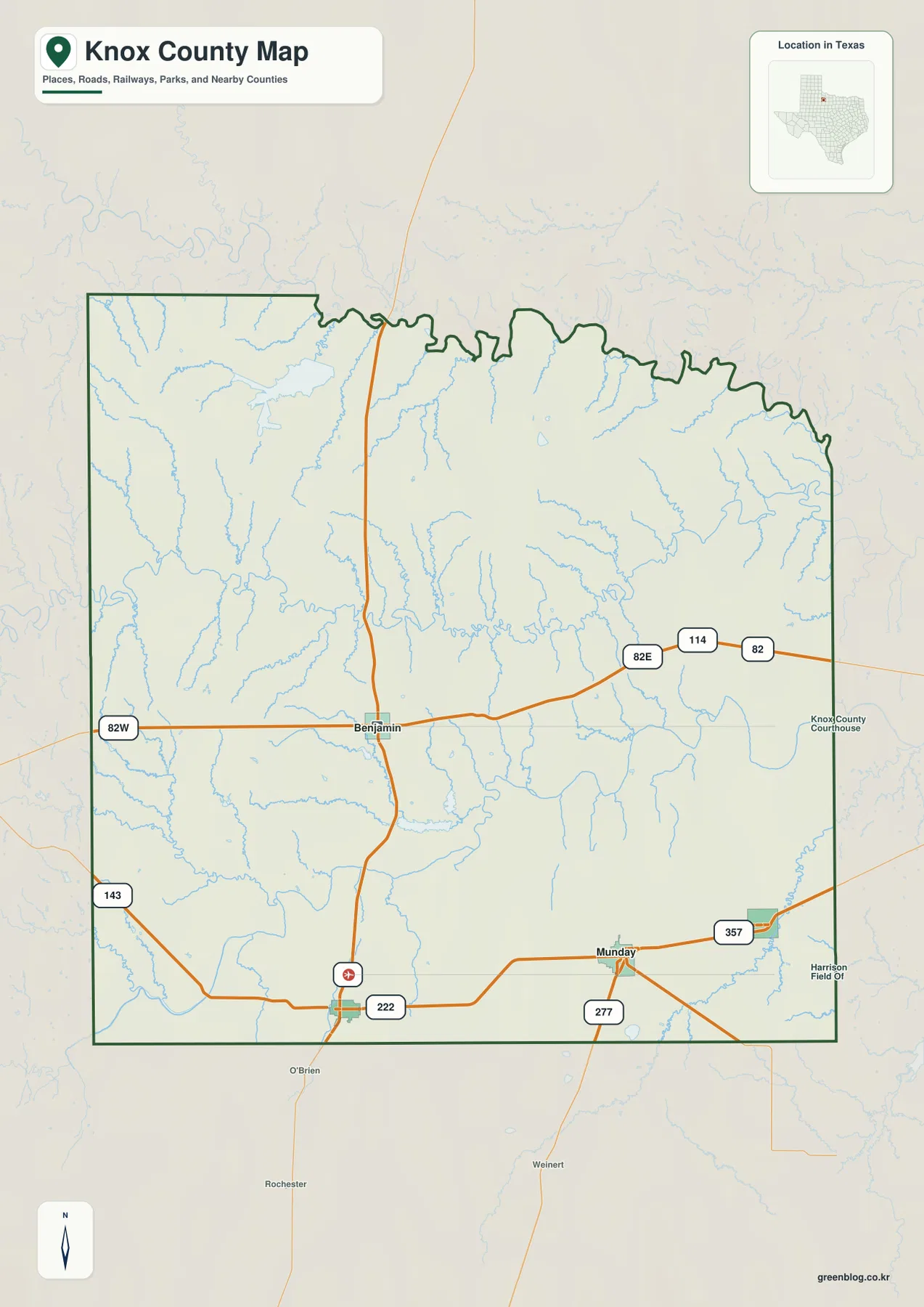
The city-connections view changes the emphasis from Benjamin to Munday. In the supplied index, Munday is ranked first and marked as the hub, followed by Knox City, Benjamin, and Goree. This simpler presentation removes most minor road labels and makes the relative placement of the four principal communities easier to see. Knox City lies west of Munday, Benjamin is farther north, and Goree is immediately to the east of the Munday area.
The connection panel lists Munday to Goree as 6 miles, Munday to Knox City as 11 miles, and Munday to Benjamin as 13 miles. These are straight-line distances, not driving distances measured along the road network. They should therefore be used to compare relative separation rather than to estimate travel time. The distinction matters because the general county map shows roads bending and changing direction between communities instead of following perfectly straight lines.
Neighboring county names surround the city map: Foard County to the north, Baylor County to the northeast, Throckmorton County to the east, Wilbarger County to the southeast, Stonewall County to the southwest, King County to the west, and Haskell County to the northwest. This makes the city view useful for regional orientation as well as local settlement locations. When exact road numbers are needed, the general map remains the better companion.
South Wichita River, Brazos River, and a network of smaller waters
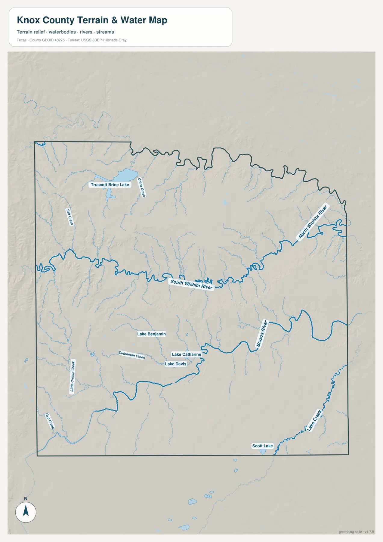
The terrain and water map makes the South Wichita River the most obvious channel across the northern half of the county. It enters from the west and runs across the central-northern area, receiving many smaller tributaries from both sides. Near the northeastern edge, the North Wichita River is labeled separately. Seeing both names on the same map is important because a reader looking only at the general road view could easily miss how much of the county’s northern boundary and interior are shaped by drainage lines.
The Brazos River is the other major named river on the map, appearing farther east and extending through the eastern and southeastern portion of the county. Several smaller lakes are positioned south of the South Wichita River. Lake Benjamin is marked to the west, while Lake Catharine and Lake Davis appear closer to the central-southern part of the map. Scott Lake and Lake Creek are labeled near the southeastern boundary, giving that corner of the county its own set of water references.
The northwestern portion contains Truscott Brine Lake, one of the easiest small water bodies to identify because it is labeled prominently. China Creek and Salt Creek appear nearby, while Little Croton Creek and Gin Creek are farther south on the western side. Dutchman Creek is labeled closer to Lake Benjamin. These smaller features are precisely the kind of details that benefit from the high-resolution download, because their names can become difficult to read when the entire county is reduced to a web preview.
This map should be read as a geographic water reference, not as a flood map, navigation chart, parcel map, or statement about water depth. Its main value is positional: it shows where the South Wichita River, North Wichita River, Brazos River, lakes, and named creeks lie within the same county boundary used by the road and elevation maps. That makes it possible to compare a road corridor or community with nearby water features without inventing hydrologic conclusions that the map does not provide.
Elevation ranges from about 362 to 545 meters
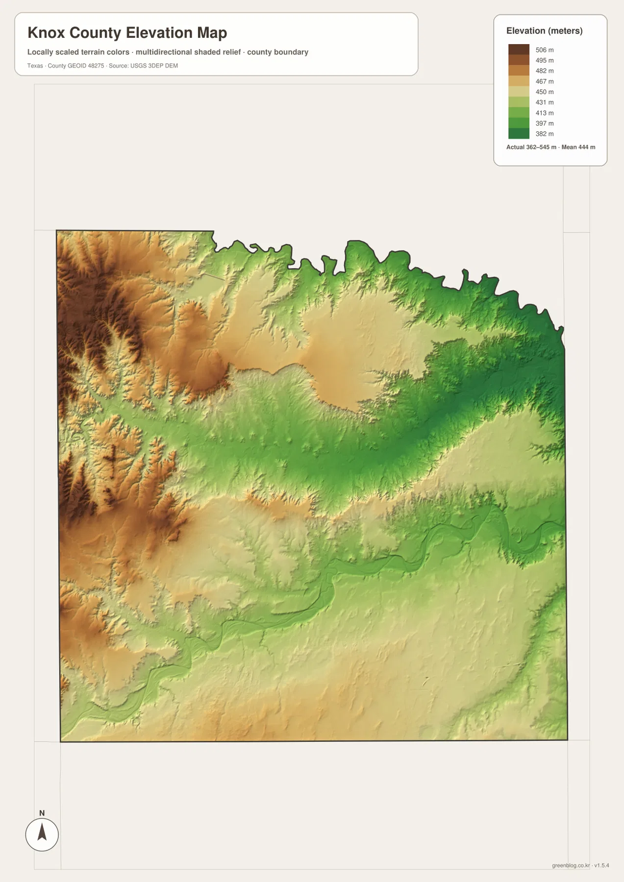
The elevation map lists an actual county range of about 362 to 545 meters, with a mean elevation of about 444 meters. The most obvious high ground is in the west and especially the northwest, where browns and oranges cover broad areas. Greens become more common toward the northeast and east, while yellow and light-green areas occupy much of the center. The map therefore shows a meaningful internal difference even though Knox County does not contain a single dramatic mountain mass on this generalized surface.
River valleys appear as lower bands within the broader terrain. The South Wichita River corridor cuts across the center-north in greener colors than nearby high ground, and the Brazos River in the east also follows a visibly lower zone. In the western high areas, smaller branching valleys interrupt the brown and orange surface, which helps explain why a simple statement such as “the west is high” is only part of the picture. The western side is generally higher, but local creek valleys remain lower than the ridges around them.
The elevation image is best used for county-scale comparison rather than engineering or survey work. Its values and shaded relief help a reader compare Benjamin and Munday with the higher northwestern terrain and the lower eastern river corridors. They should not be treated as an exact ground elevation for a parcel, road shoulder, or structure. For that type of measurement, a more detailed elevation dataset would be required.
A practical way to compare the four supplied maps
For a first pass, find Benjamin and U.S. 82 on the general map, then trace the southern road network toward Knox City and Munday. On the city-connections map, switch the reference point to Munday and compare the straight-line distances to Goree, Knox City, and Benjamin. This change in emphasis is useful because the two maps are answering different questions: one shows roads and geographic placement, while the other simplifies the county into a hub-and-community comparison.
For natural features, begin with the South Wichita River on the water map and then find the Brazos River and Truscott Brine Lake. Moving to the elevation map reveals how those water corridors relate to lower terrain and how the higher western side differs from the greener east. The shared county outline makes these cross-checks straightforward, and it also helps prevent a named creek or lake from being mistaken for a feature outside Knox County.
The best map depends on the task. Use the general county map for road numbers and settlement locations; use the city view for Munday-centered community spacing and neighboring counties; choose the terrain and water map for named rivers, creeks, and lakes; and use the elevation map for the broad difference between western high ground and eastern low areas. When a label is too small in the web preview, the high-resolution JPG files below are the better version to inspect.
Frequently Asked Questions
Are the distances from Munday driving distances?
No. The city-connections map lists Goree at 6 miles, Knox City at 11 miles, and Benjamin at 13 miles from Munday, but those are straight-line distances. Actual driving distances can be longer because roads do not follow perfectly straight paths.
Where do the South Wichita River and Brazos River appear?
The South Wichita River crosses the central-northern part of the county from the west toward the east, while the Brazos River is shown farther east and southeast. The North Wichita River is also labeled near the northeastern edge, so the water map provides three major river references within or along the county.
What is the main elevation contrast in Knox County?
The supplied elevation map reports about 362–545 meters, with a mean of about 444 meters. The west and northwest are generally higher, while lower green terrain becomes more extensive toward the east and along major river corridors.
Sources and Reference Data
- U.S. Census Bureau TIGER/Line Shapefiles — official geographic data for county boundaries and transportation features.
- USGS National Hydrography — official reference data for rivers, creeks, lakes, and other water features.
- USGS 3D Elevation Program — official source program for elevation and terrain data.
- USGS The National Map Viewer — official map viewer for comparing multiple geographic layers.
Map File Information
Download four high-resolution A3 JPG maps of Knox County in one ZIP file.
- Included Files: county map, city-connections map, terrain and water map, elevation map
- File Type: JPG
Related Maps
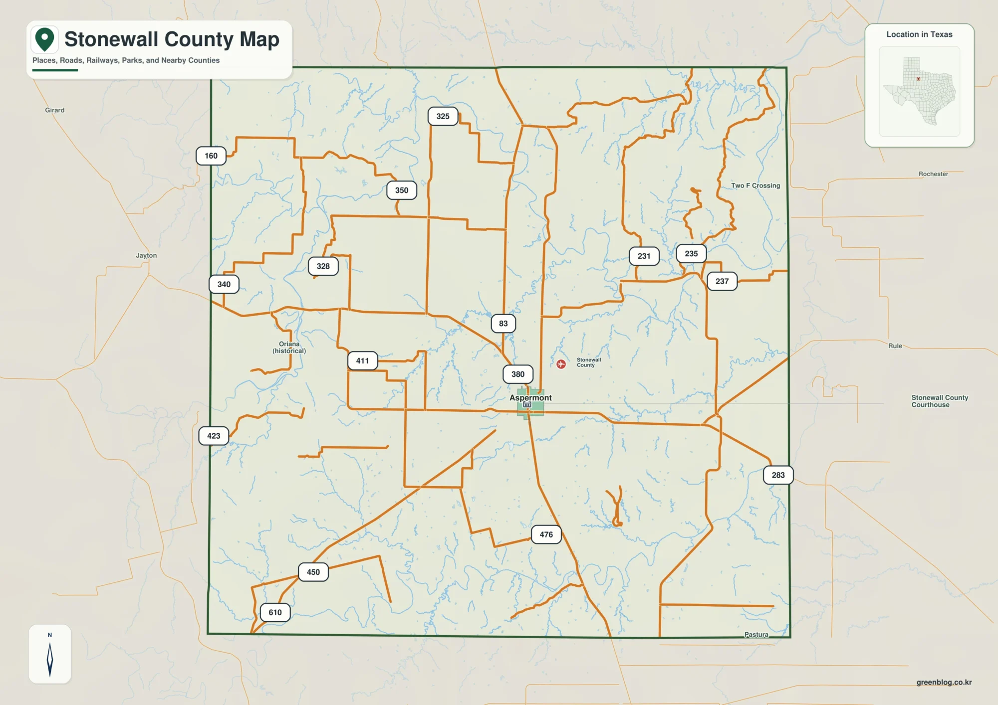
- Baylor County Texas map
- Stonewall County Texas map
- Wilbarger County Texas map
- Shackelford County Texas map
- Throckmorton County Texas map
Green Map creates custom-edited map images using open geographic data sources such as geoBoundaries, Natural Earth, OpenStreetMap, and government open data.
These maps are edited visual materials, not raw data files, and are provided for education, documents, presentations, and graphic reference.