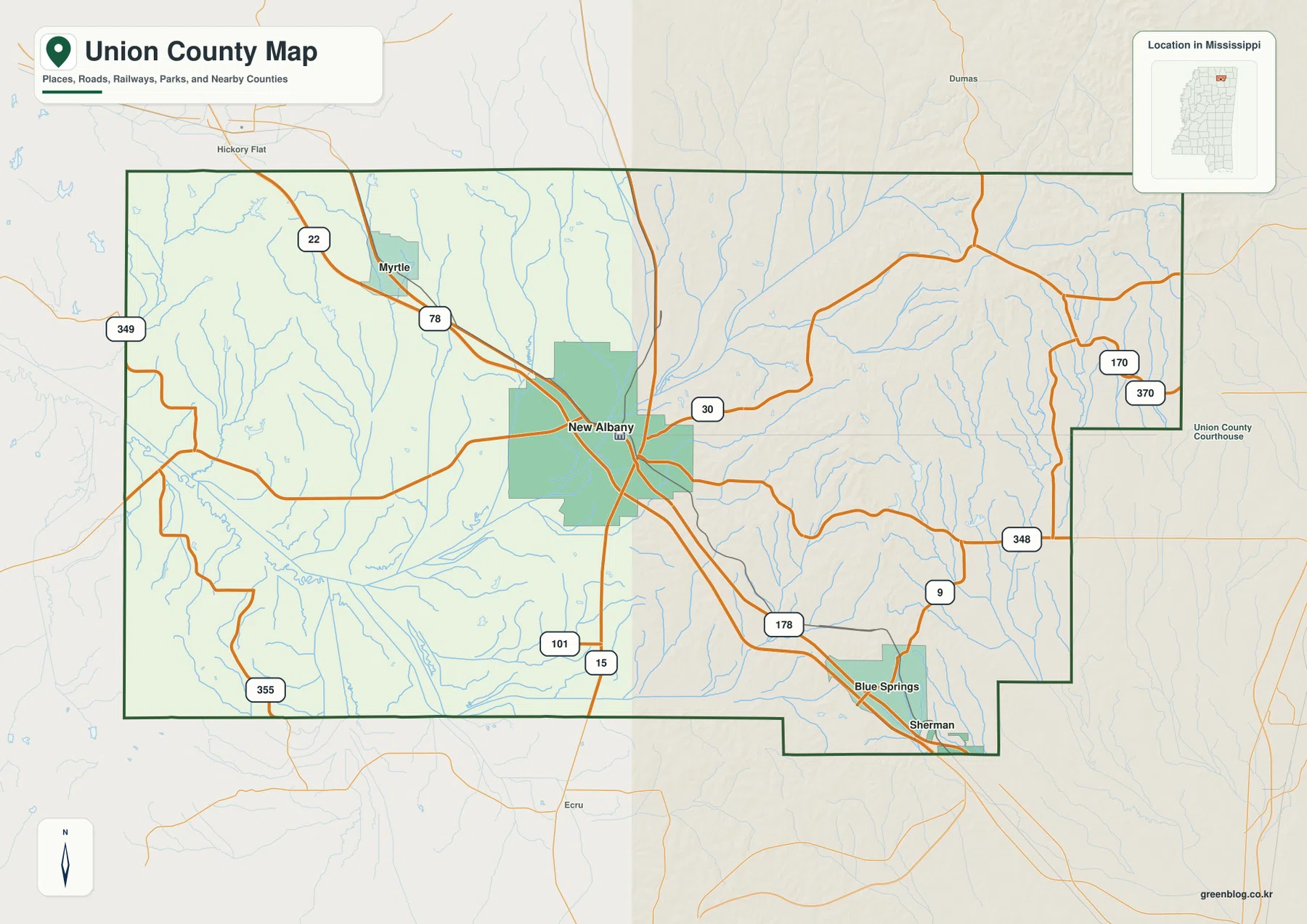
Union County Mississippi Map files are available to download from this page in high-resolution A3 JPG format. New Albany is the central reference, with Myrtle northwest along the I-22/US 78 direction and Blue Springs plus Sherman toward the southeast. The water view adds Little Tallahatchie River, Tallahatchie River, Cane Creek, Hatchie River, Ridge Creek, and several small lakes, while the elevation map records an actual range of about 87 to 227 meters. Together, the maps show a county where a broad low western valley gives way to much more closely spaced hills and stream cuts in the east.
New Albany is useful as the starting point because roads, settlement, and terrain all change around it. To the west and southwest, the Little Tallahatchie drainage occupies a broad green lowland. East of New Albany, ridges become narrower and more numerous, and the northeastern corner contains the strongest high relief on the elevation map. I-22/US 78 cuts diagonally across this transition, tying Myrtle to New Albany and then continuing toward Blue Springs and Sherman. That combination of a major road corridor and contrasting hill country gives Union County a more specific geographic identity than a generic “manufacturing corridor” description suggests.
Table of Contents
New Albany at the junction of I-22 and the county road network
I-22 and US 78 provide the clearest diagonal route across the general county map. The corridor enters from the Myrtle side, reaches New Albany, and continues southeast toward Blue Springs and Sherman. MS 15 runs through the New Albany area on a more north-south line, while MS 30 heads east into the hillier northeastern interior. Using those three roads first makes the rest of the county much easier to orient.
Additional state roads fill in the outer sections. MS 178 follows the southeastern travel direction near Blue Springs and Sherman. MS 9 and MS 348 appear in the eastern half, and MS 170 with MS 370 helps define the northeast. On the west side, MS 349 and MS 355 serve more rural areas, while MS 101 is labeled farther south. The map is not intended to replace detailed local navigation, but it clearly shows which routes connect New Albany with the county’s smaller communities and neighboring counties.
The county outline is also worth noticing. The east side steps inward before projecting southeast around the Blue Springs-Sherman area, so it does not read like a simple rectangle. Tippah and Benton counties lie to the north, Lee and Prentiss counties are east, Pontotoc County is south, and Lafayette plus Marshall counties frame the west. In the eastern half, where roads and boundary turns are close together, reading the county line alongside MS 30, MS 348, and MS 9 prevents confusion about which side of the border a place occupies.
Myrtle and Blue Springs measured from New Albany
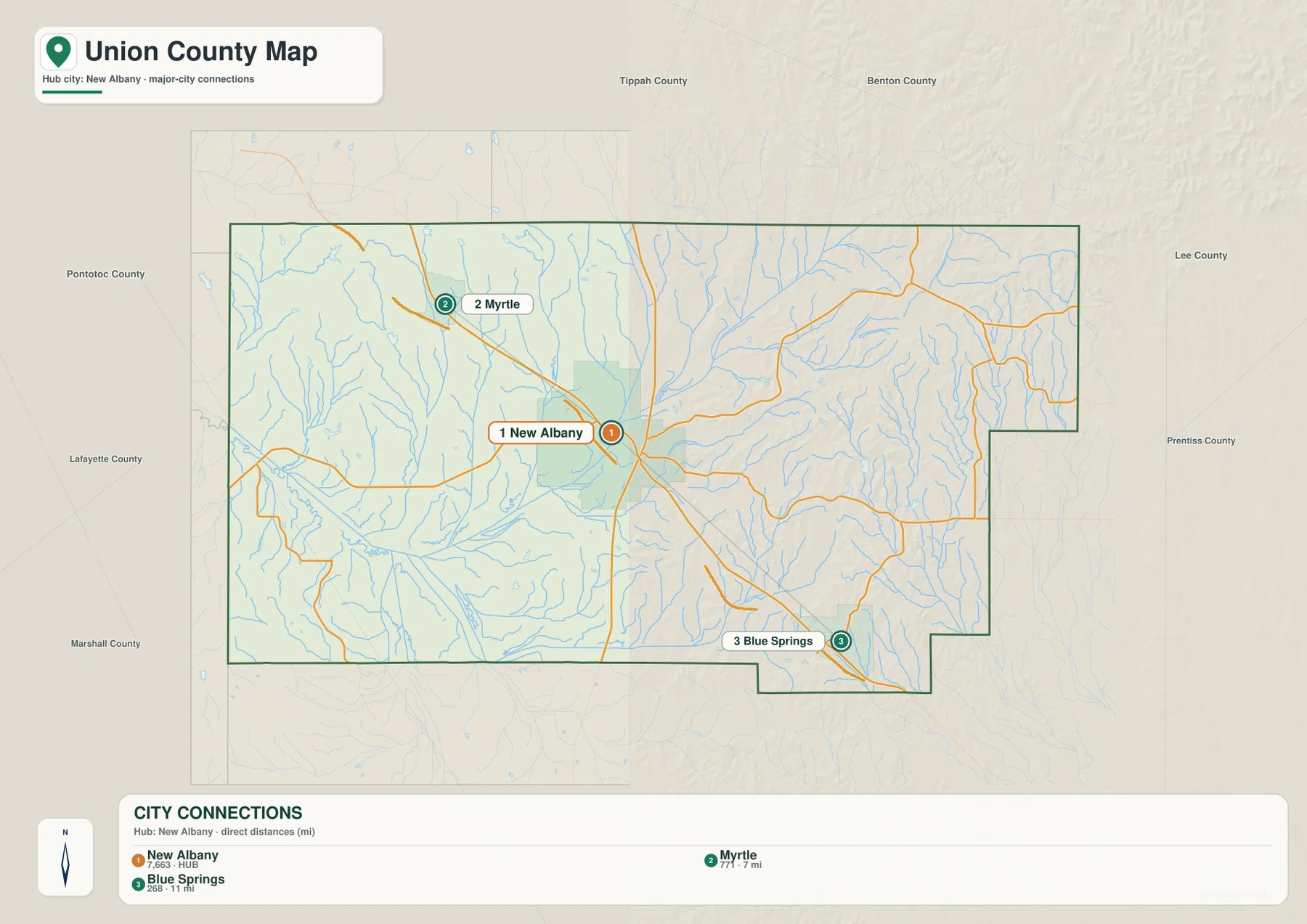
The city-connections map reduces the county to three selected communities. New Albany is the hub. Myrtle is shown about 7 miles away by straight-line distance and sits northwest along the I-22/US 78 direction. Blue Springs is about 11 miles from New Albany and lies southeast on the opposite side of the hub. These labels are direct point-to-point distances, not driving mileage, so actual road trips will follow longer routes.
The same city index lists New Albany at 7,663 residents, Myrtle at 777, and Blue Springs at 268. That ranking is useful for comparing the scale of the three selected places rather than describing Union County’s total population. New Albany stands out as the administrative and service center, while Myrtle and Blue Springs act as smaller location markers along the major diagonal corridor.
Sherman appears on the general map but not in this three-place city ranking. That is a good example of why the maps are complementary. The city view is cleaner when the question concerns New Albany, Myrtle, and Blue Springs; the general county map is better when Sherman, boundary turns, and the wider road network also matter.
Little Tallahatchie lowlands and separate eastern drainage
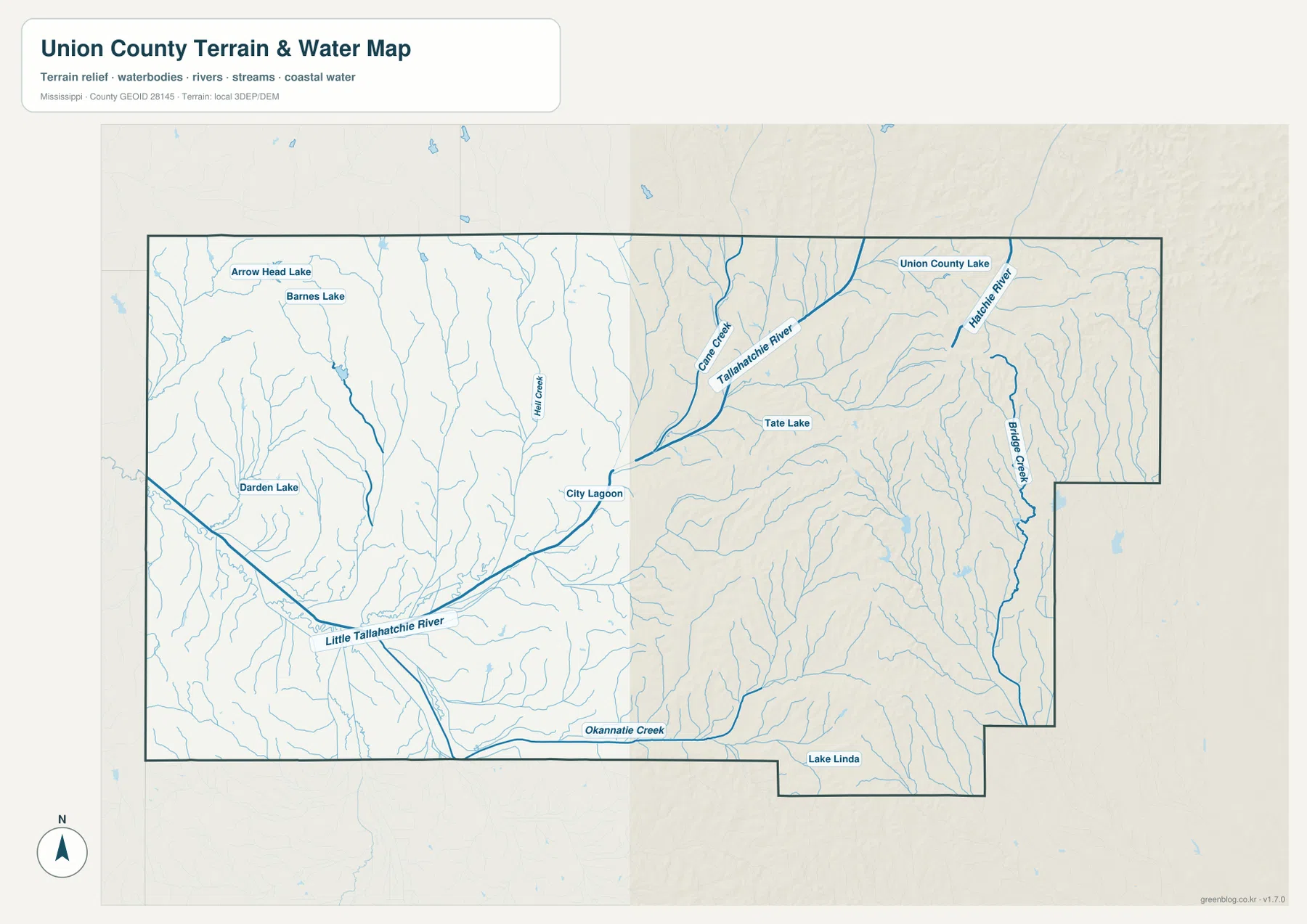
Little Tallahatchie River is the strongest water reference across the western and south-central part of the terrain-and-water map. It moves through a broad low valley and gathers numerous smaller tributaries descending from the surrounding hills. City Lagoon is labeled near New Albany, and Flint Creek runs southward nearby. Arrow Head Lake and Barnes Lake sit in the northwest, while Darden Lake provides another western water reference.
The northeastern half belongs to a different-looking drainage pattern. Tallahatchie River appears near Cane Creek, with Union County Lake and Tate Lake close to that system. Hatchie River is labeled along the eastern side, and Ridge Creek runs through a long valley below it. Okannatie Creek and Lake Linda appear close to the southern edge. The map therefore shows several drainage directions rather than one river collecting every stream in the county.
This separation becomes clearer when the water view is compared with the elevation surface. Short tributaries descend from the narrow eastern ridges, while the western Little Tallahatchie side opens into a much broader low corridor. The water map is designed for location and landscape context. Flood zones, legal water boundaries, dam safety, water quality, and navigation questions need more specialized current sources.
From an 87-meter western valley to 227-meter northeastern hills
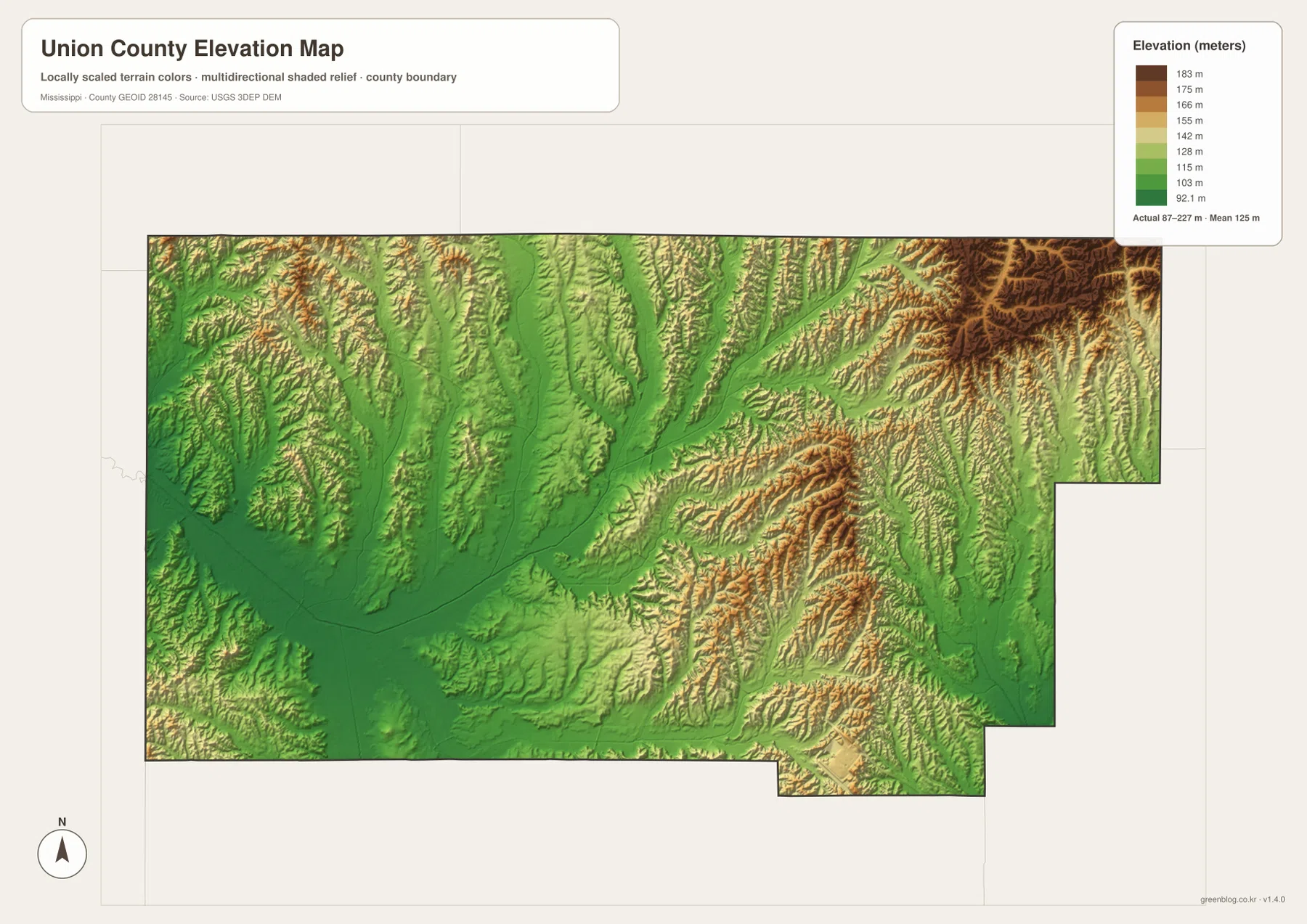
The elevation map gives an actual county range of about 87 to 227 meters and a mean of about 125 meters. Broad green low ground dominates the west and southwest, closely matching the Little Tallahatchie River valley. New Albany also sits within relatively moderate terrain. Moving north and east, the map becomes increasingly textured as yellow, orange, and brown ridges appear between narrow green stream corridors.
The northeastern corner contains the darkest high terrain and some of the closest-spaced ridge patterns. East-central and southeastern Union County also contains long hill crests divided by tributary valleys. Blue Springs and Sherman sit on this more broken side of the county, which contrasts strongly with the broad western lowlands. Ridge Creek and other eastern streams can be matched directly with green valleys on the elevation view.
The west is not perfectly flat. Myrtle and the northwestern interior contain smaller ridges, and tributaries cut their way toward the Little Tallahatchie system. The difference is one of scale: western valleys are generally broader and lower, while eastern relief is more tightly packed. This is why the elevation map adds useful information that cannot be inferred from the highway corridor alone.
Use the elevation colors for countywide comparison rather than site-specific measurement. They are not survey-grade elevations for a house, factory parcel, road grade, drainage design, or construction decision. On this page, the map is most useful for locating the broad Little Tallahatchie lowland and seeing where the higher eastern and northeastern ridges begin.
New Albany and Blue Springs as different local reference points
The existing package describes New Albany as the county seat and the main courthouse, retail, and medical center. Its location near I-22/US 78 and MS 15 supports that role geographically: roads from several directions converge near the city before continuing into the surrounding hill country. Both the general map and the city-connections view give New Albany the strongest visual emphasis.
Blue Springs is much smaller in the city ranking but has a different kind of regional significance. The supplied source catalog includes Toyota Motor Manufacturing Mississippi, and the existing article places the plant near Blue Springs in eastern Union County rather than in downtown New Albany. I-22/US 78 and MS 178 make the southeast direction easy to follow on the map, so the administrative center and the major industrial reference can be kept geographically distinct.
Myrtle anchors the northwest side of the same diagonal corridor. Sherman sits near the southeastern county boundary, where the existing FAQ material notes that the community crosses the Union-Pontotoc county line. That boundary position is visible on the general map and is a useful reminder that a community name does not always fit neatly inside one county outline.
Population and area behind the map scale
The supplied Census references list 27,777 residents in the 2020 census and a July 2025 estimate of 28,459. Because the two figures come from different reference dates and methods, they work best as separate markers of recent county size. They also help put the city ranking in perspective: New Albany is the largest selected community, but much of Union County consists of rural roads, farms, woods, stream valleys, and smaller settlements outside the city.
The 2025 Gazetteer values in the package list 415.607 square miles of land and 1.301 square miles of water. Dividing the 2020 count by that land figure gives about 66.8 residents per square mile. That countywide average does not mean people are spread evenly across New Albany, the I-22 corridor, the Blue Springs industrial area, broad western valleys, and the higher eastern ridge country.
Which Union County map is most useful?
The general county map works best when New Albany, Myrtle, Blue Springs, Sherman, I-22, MS 15, and the county boundary all need to appear together. The city-connections map is the cleaner choice for comparing Myrtle and Blue Springs from a New Albany hub and using the printed straight-line distances. The water map gives the most detail for Little Tallahatchie River, Tallahatchie River, Cane Creek, Hatchie River, and the named lakes. The elevation view explains the strong physical contrast between broad western lowlands and the narrower eastern hill-and-valley terrain.
For a classroom or presentation, the road and city maps make a useful pair when the subject is settlement and transportation. For physical geography, place the water and elevation views side by side. The broad Little Tallahatchie valley, narrow eastern tributaries, and surrounding ridges line up clearly between the two graphics, making the county’s terrain understandable without relying on technical GIS terms.
Frequently Asked Questions
Is the Toyota plant in downtown New Albany?
No. The existing package material places Toyota Motor Manufacturing Mississippi near Blue Springs in eastern Union County. New Albany is the county’s administrative and service center, while the plant area is farther southeast along the I-22/US 78 corridor.
Is Sherman entirely inside Union County?
The existing material says Sherman crosses the Union County-Pontotoc County boundary. The general map places the community directly against the southeastern county edge, so the county line should be checked along with the place name when precise jurisdiction matters.
Map File Information
The ZIP packages the Union County county, city, water, and elevation maps as high-resolution A3 JPG originals. They are larger than the WebP page previews and give more room for labels and terrain detail in printed handouts, edited graphics, or classroom materials.
- File Type: four high-resolution JPG files in one ZIP
Related Maps
Sources and References
- U.S. Census Bureau QuickFacts for Union County — population reference
- U.S. Census Bureau Gazetteer Files — land and water area reference
- Mississippi Department of Transportation Official Highway Map — I-22, MS 15, and state-road reference
- USGS National Hydrography — river, creek, and lake reference
- USGS 3D Elevation Program — elevation and terrain reference
- Toyota Motor Manufacturing Mississippi — Blue Springs regional industry reference
Green Map creates custom-edited map images using open geographic data sources such as geoBoundaries, Natural Earth, OpenStreetMap, and government open data. These maps are edited visual materials, not raw data files, and are provided for education, documents, presentations, and graphic reference.