Marion County in south-central Mississippi is easiest to understand by starting with Columbia, then following the roads, water, and relief outward from that point. The supplied county map places Columbia near the center of the road network, with Foxworth and Kokomo providing useful western references. The water map shows the Pearl River running through a broad central corridor with named creeks and small lakes on both sides, while the elevation map separates that low corridor from higher ground along the western edge and in the northeast. You can download the four corresponding high-resolution A3 JPG files in one ZIP after reviewing the WebP previews on this page.
The maps also correct a problem that can arise when older descriptive text is read without the current graphics. The supplied city map labels Jefferson Davis, Lamar, Walthall, Lawrence, and Pearl River counties around Marion County; it does not show Marion County touching Louisiana. Red Bluff remains a useful regional terrain reference from the existing article material, but its name is not printed on any of the four current map images. For that reason, the discussion below gives priority to places and features that can be located directly on the supplied county, city, water, and elevation maps.
Table of Contents
Columbia anchors the road network inside an irregular county outline
On the county map, Columbia is the clearest place to begin. US 98 crosses the county from the western side through Columbia and continues east, while MS 35 runs south from the Columbia area through the long lower part of the county. Other labeled routes include MS 44, MS 13, MS 43, MS 48, and the 586 and 587 routes on the western side. Foxworth sits immediately west of Columbia, and Kokomo appears farther west, so the map gives three easy place references for reading the road pattern before moving to the smaller streams and terrain details.
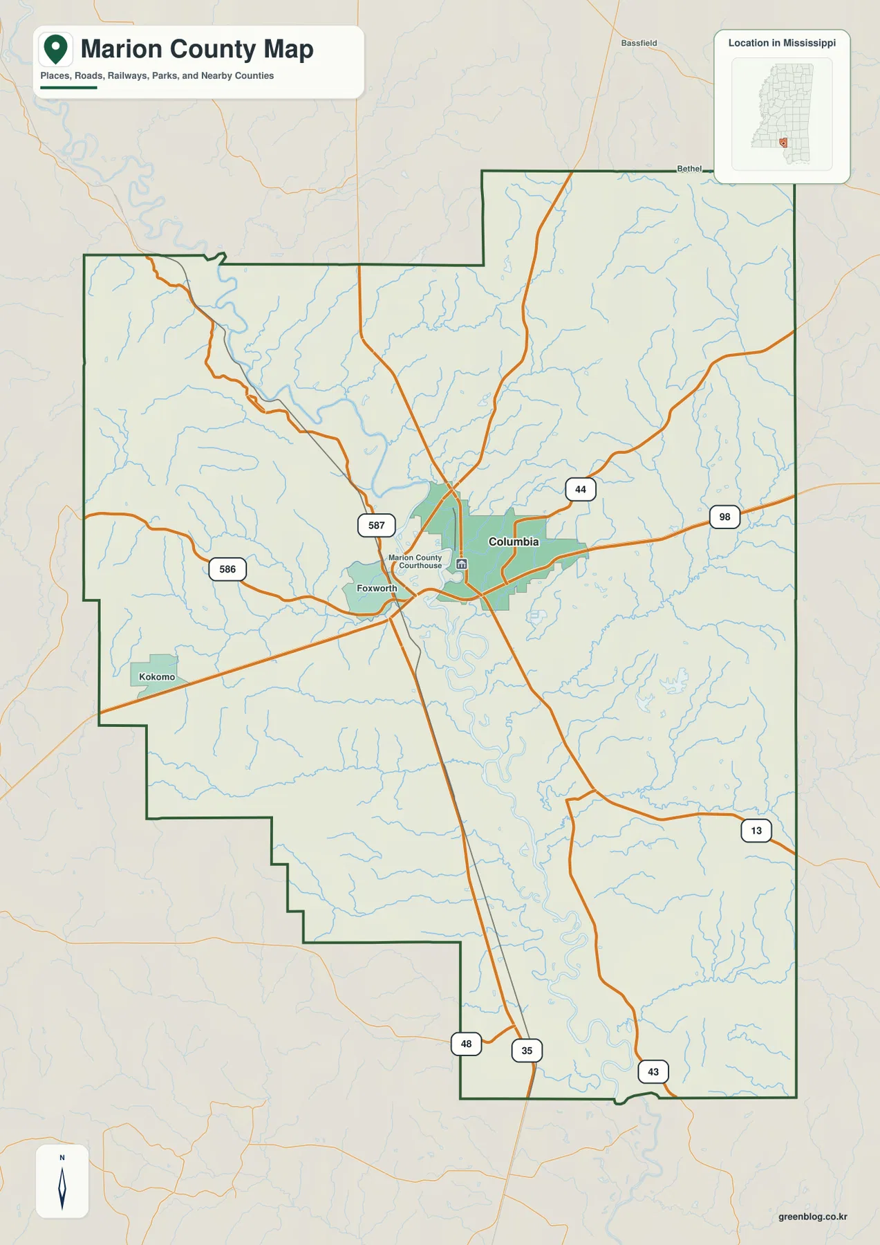
The outline itself helps explain why one central point cannot describe every part of the county. The northern half is broad, with a large northeastern extension, while the southern part becomes longer and narrower. The city-map frame identifies Jefferson Davis County to the north, Lamar County to the east, Walthall County on the west, Lawrence County along the western side farther south, and Pearl River County toward the southwest. Those labels are more reliable for orientation than the older wording that described Marion County as reaching the Louisiana line.
| Item | What the supplied material shows |
|---|---|
| County seat | Columbia |
| FIPS code | 28091 |
| 2020 census population | 24,441 |
| July 2025 population estimate | 24,001 |
| 2025 Gazetteer land area | 542.326 square miles |
| 2025 Gazetteer water area | 6.294 square miles |
| Simple countywide density reference | About 45.1 residents per square mile using 2020 population ÷ 2025 land area |
| Elevation-map actual range | About 26–144 m, mean about 78 m |
The population figures should not be treated as measurements from the same date. The 24,441 count is the 2020 census value, whereas 24,001 is the July 2025 estimate supplied with the package. The 45.1-per-square-mile figure is only a countywide calculation using the 2020 population and the 2025 Gazetteer land area. It does not mean homes are distributed evenly across the county. The city map, in fact, makes the opposite point: one principal city is highlighted while large rural areas contain no ranked city marker at all.
The city index identifies one dominant population center rather than a chain of large towns
The supplied city map is intentionally simple. Its CITY INDEX contains one ranked major city: Columbia, shown as number 1 with a value of 6,632. That city figure covers a different geography from the county population and should not be compared as though both numbers describe the same boundary. The useful message is visual: Columbia is the single clearly ranked urban reference on this map, and it sits close to the middle of the county’s road and river system.
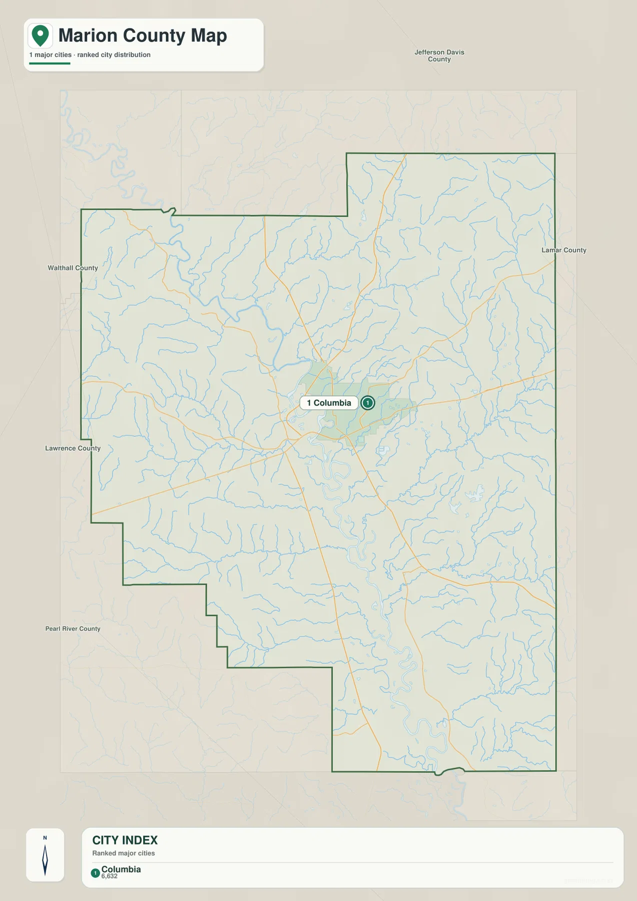
Foxworth and Kokomo appear on the general county map but not as separate ranked major cities on this city-index layer. That distinction matters. A labeled place on a reference map is not necessarily a city large enough to appear in the ranked city layer, and the absence of a label does not mean an area is uninhabited. The city map is designed to simplify settlement comparisons, not to replace a street map, address finder, or complete community directory.
The neighboring-county labels also make Columbia’s position easier to understand. Jefferson Davis County lies to the north, Lamar County is to the east, and Walthall County appears to the west. Lawrence County and Pearl River County provide additional western and southwestern references. Reading those names around the boundary is useful when planning a broader county-to-county comparison, because the Marion County outline has several steps and projections that are easy to misread when viewed without surrounding labels.
Pearl River is the water spine, with named creeks and small lakes distributed around it
The water map gives the Pearl River a much stronger visual role than the general road map. It enters the county from the upper-left side of the mapped area, passes through the central portion, and then follows a series of increasingly obvious bends toward the south. Many smaller streams join the broader river corridor. Dry Creek and Holiday Creek are labeled in the northwestern sector, Silver Creek crosses the western-central side, and Tennille Creek appears farther southwest. On the eastern side, Upper Little Creek and Lower Little Creek are shown as separate named channels.
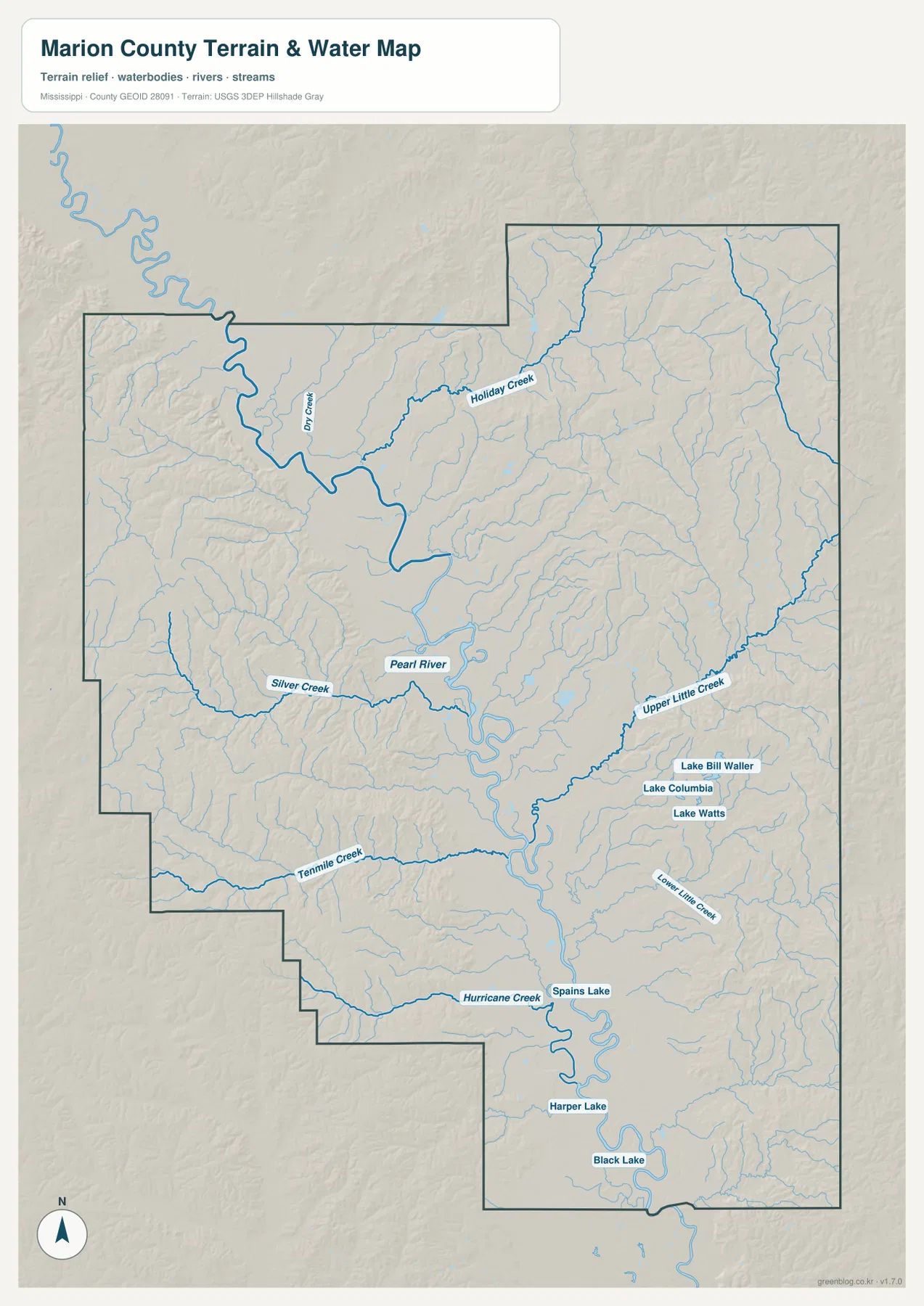
Several named lakes are clustered east and southeast of the central river corridor. Lake Bill Waller, Lake Columbia, and Lake Watts appear close together, while Spains Lake is farther south near the Pearl River. Harper Lake and Black Lake are labeled in the lower part of the county, and Hurricane Creek approaches the southern river area from the southwest. These features are easier to remember by location than as a list: first locate the Pearl River, then look west for the larger named creeks, east for the group of small lakes, and south for the pronounced river bends and additional lake labels.
This is a reference water map, not a flood or navigation product. It does not provide live river stages, flood depths, regulated shoreline boundaries, parcel lines, or guarantees that every small channel is shown. The Pearl River corridor contains numerous bends and minor drainage features that may be generalized at county scale. Anyone evaluating flood exposure, access to a particular bank, drainage design, or legal water boundaries should use the current specialized data from the relevant state or federal agency.
A 26–144 meter range reveals a low river corridor between higher uplands
The elevation map reports an actual Marion County range of about 26 to 144 meters, with a mean near 78 meters. The colors are locally scaled so that differences inside this county are easy to see. The broad green band running north to south through the middle is the most important feature. When it is compared with the water map, that low band follows the general Pearl River corridor and its adjoining valleys rather than appearing as an unrelated patch of low ground.
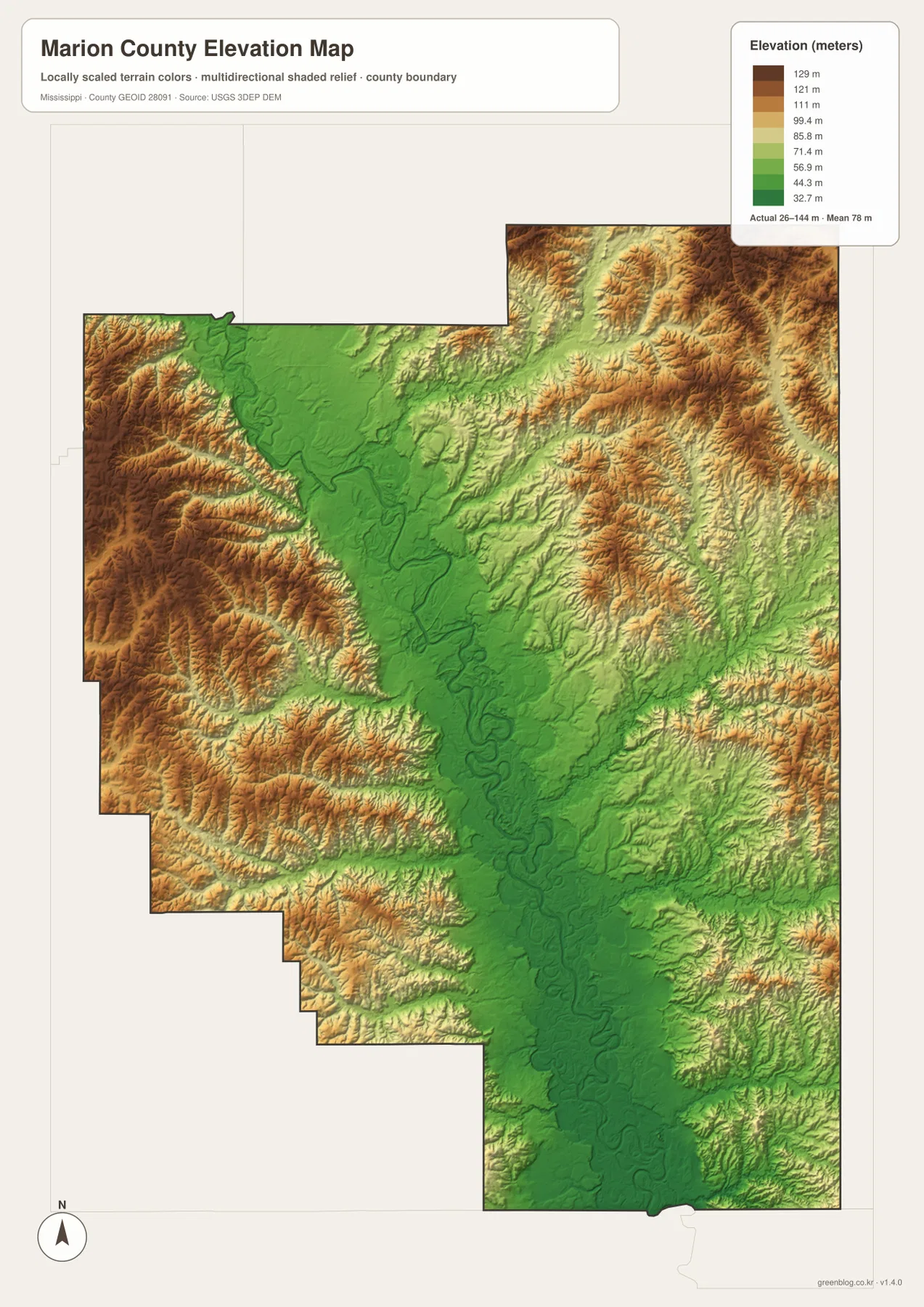
Higher relief is especially visible along much of the western edge, where brown and darker tan ridges form repeated bands. The northeast and parts of the east also contain strongly dissected uplands, though the pattern is not identical to the west. Numerous small valleys cut into those higher areas. The central river corridor stays lower for a long distance, and the lower southern section continues to show the influence of the river and its bends. This combination is more informative than simply calling the county flat or hilly; both low valley terrain and rolling uplands are important parts of the map.
The elevation surface is suitable for county-scale comparison, not site engineering. The 26–144 m range and 78 m mean help show the difference between the Pearl River lowland and the surrounding uplands, but they should not be used to assign an exact elevation to a house, road shoulder, drainage structure, or property corner. For a precise point elevation, the underlying USGS 3D Elevation Program data or a professional survey is the appropriate source.
Comparing the same locations across all four maps explains more than any one layer
Columbia is a good example of why the maps work better together. On the county map it is the road center, with US 98 and multiple state routes meeting nearby. On the city map it is the only ranked major city. On the water map it lies close to the central Pearl River system, and on the elevation map that same central zone is part of the broad lower corridor. The relationship between settlement, roads, water, and relief therefore becomes much clearer than it would be from a city list or highway list alone.
The western side has a different combination. Foxworth and Kokomo provide the main place references on the county map, while Silver Creek, Dry Creek, and Holiday Creek appear on the water layer. The elevation map shows higher ridges along much of the western margin. Red Bluff belongs to the broader western Marion County terrain context described in the older article material, but the current four maps do not print a Red Bluff label. These files are therefore useful for general orientation around the western uplands, not for locating a Red Bluff trailhead, access road, parcel, or site boundary.
South and east of Columbia, the map emphasis shifts again. Upper and Lower Little Creek, the Lake Bill Waller–Lake Columbia–Lake Watts cluster, and the southern Pearl River bends add detail that is not prominent on the road map. Farther south, Spains Lake, Harper Lake, Black Lake, and Hurricane Creek provide additional water references. The elevation colors show how these channels occupy lower ground between surrounding hills. Reading the water and elevation maps together is the easiest way to see why drainage lines and relief are closely related without turning the article into a technical terrain report.
Choose the file that matches the question, then use the A3 download for detail
The four supplied files are designed for different reading tasks. Start with the county map when you need Columbia, Foxworth, Kokomo, the county outline, and the numbered road network on one page. Use the city map when the question is simply where the principal urban center sits relative to the surrounding counties. The water map is much clearer for Pearl River, named creeks, and the lake cluster east of the river. The elevation map is the best choice for comparing the low central corridor with the higher western and northeastern terrain.
- County map: best for Columbia, western place labels, US 98, MS 35, other numbered routes, and the overall boundary.
- City map: best for the single ranked major city, Columbia, and for seeing the surrounding-county labels without extra thematic detail.
- Water map: best for Pearl River, Dry Creek, Holiday Creek, Silver Creek, Upper and Lower Little Creek, Hurricane Creek, and the named lakes.
- Elevation map: best for the countywide 26–144 m range and the contrast between the lower central valley and higher uplands.
The WebP images embedded in the article are optimized for quick viewing. For printing, classroom use, larger displays, or closer inspection of labels, the downloadable ZIP contains four high-resolution A3 JPG files corresponding to the county, city, water, and elevation maps. These files are general reference maps; they are not cadastral plats, legal boundary surveys, real-time navigation maps, flood-hazard determinations, or engineering-grade elevation products.
Frequently Asked Questions
What is the best starting point for reading a Marion County map?
Columbia is the most useful starting point in the supplied material. It is the county seat, the main road-centered place on the general map, and the only ranked major city on the city-index map. Its position near the Pearl River corridor also makes it easy to match the same location across the road, water, and elevation maps.
Is Red Bluff labeled on these four Marion County map files?
No. Red Bluff is part of the regional terrain context in the existing article material, but the current county, city, water, and elevation images do not print a Red Bluff label. The maps can help with broad western Marion County orientation, but they should not be used to identify a precise Red Bluff access point, property line, or local road.
Where is the broadest low-elevation corridor on the elevation map?
The most continuous low area runs through the central part of the county along the general Pearl River corridor. Higher terrain is more prominent along much of the western edge and in the northeastern and eastern uplands. The map reports an actual range of about 26 to 144 meters with a mean near 78 meters, but exact site elevations require the underlying USGS data or a survey.
Sources and reference data
Population and area figures follow the Census references included with the package. Road, hydrography, and elevation descriptions are based on the supplied map images and the official reference links below. Use the source agencies when you need information that is newer or more precise than a county-scale downloadable map.
- U.S. Census Bureau Marion County QuickFacts
- U.S. Census Bureau Gazetteer Files
- Mississippi Department of Transportation official highway map
- USGS National Hydrography
- USGS 3D Elevation Program
- Mississippi DEQ Marion County RiskMAP reference
Map File Information
The ZIP contains high-resolution A3 JPG versions of the Marion County county, city, water, and elevation maps described on this page.
- Included Files: 4 map JPGs
- File Type: ZIP containing JPG images
Related Maps
Green Map creates custom-edited map images using open geographic data sources such as geoBoundaries, Natural Earth, OpenStreetMap, and government open data. These maps are edited visual materials, not raw data files, and are provided for education, documents, presentations, and graphic reference.