The Williamsburg County Map on this page combines the county’s road network, five ranked communities, and a water-and-terrain view centered on the Black River. Kingstree provides the easiest starting point, with Hemingway and Stuckey to the east and Lane and Greeleyville to the southwest. The WebP previews can be viewed directly in the article, and the matching high-resolution A3 JPG map files can be downloaded together in a ZIP archive.
The general county map is best for roads and place names. The city-distribution map removes most of that detail and shows Kingstree, Hemingway, Lane, Greeleyville, and Stuckey as ranked points. The terrain-and-water map shifts attention to the Black River, swamps, creeks, Wilson Lake, and smaller branches. Moving through the maps in that order makes it easier to start with a town, add its road connections, and then understand the surrounding drainage.
Table of Contents
Kingstree anchors a road network that spreads toward Hemingway, Lane, and the southeast
Kingstree sits slightly west of the county’s center and is the most useful road reference on the general map. Route 261 runs east from the Kingstree area, while 52 and 377 help organize the southern and southwestern side near Lane. Route 375 appears near Greeleyville, and 521 and 527 lead toward the southeastern portion of the county. Rather than treating those route numbers as a list, it is more useful to see Kingstree as the hinge between the western, eastern, and southeastern parts of Williamsburg County.
Farther east, Stuckey and Hemingway form a second recognizable cluster. Routes 51, 41, and 512 are labeled around that side of the map, giving Hemingway a road pattern that looks different from the Kingstree center. The southeastern boundary is approached by 521 and 527, while Andrews appears beyond the county as a nearby reference point. That distinction matters: Andrews helps orient the lower-right side of the map but should not be read as one of the five ranked Williamsburg County communities.
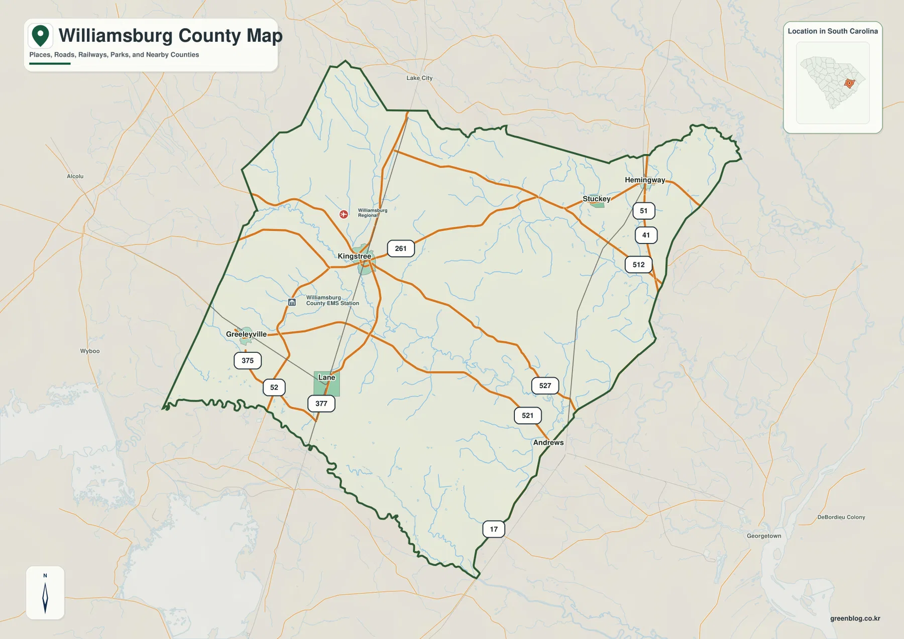
The western and northern sides are noticeably less dominated by large town labels. Greeleyville and Lane provide useful southwest references, while the north is defined more by the long county boundary, smaller roads, and nearby outside labels such as Lake City. This contrast makes the full map important: a close-up around Kingstree alone would miss how far the county extends toward the east and how much open area lies between the ranked communities.
Five ranked places form three distinct parts of the county
The city map ranks Kingstree first, Hemingway second, Lane third, Greeleyville fourth, and Stuckey fifth. These numbers are index rankings, not mileage or drive-time measurements. Their value is the simplified distribution: Kingstree is the central-western anchor, Hemingway and Stuckey are grouped in the east, and Lane and Greeleyville occupy the southwest. The arrangement is easier to grasp here than on the busier road map.
Hemingway and Stuckey sit close enough on the city view to read as an eastern pair, while Lane and Greeleyville form a separate southwestern pair. Kingstree stands between them. If the goal is to find Hemingway, start with the city map to establish the eastward direction, then switch to the general map for routes 51, 41, and 512. For Lane, the city map establishes the southwest position before the general map adds routes 52 and 377.
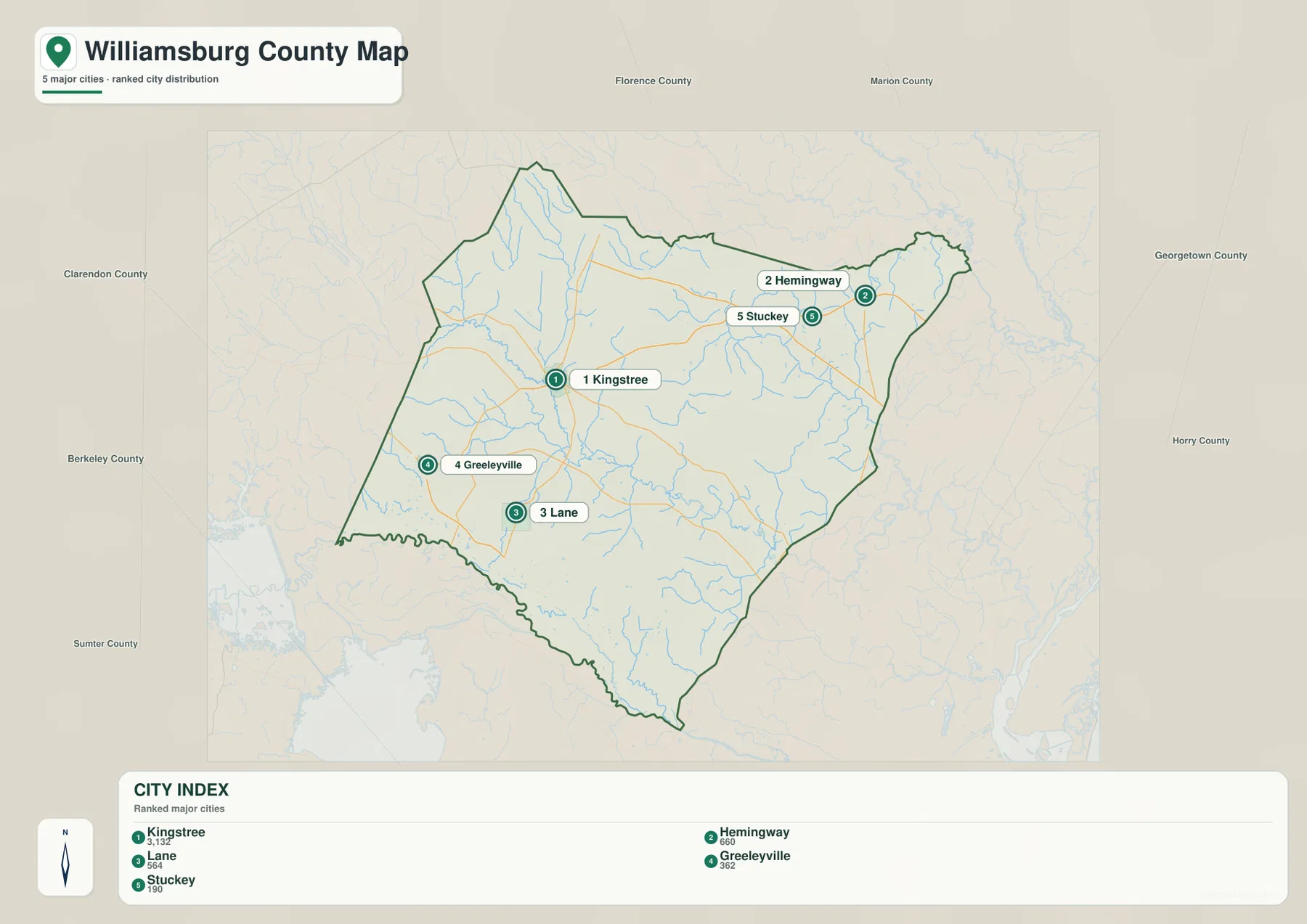
The outer labels also show how Williamsburg County sits among its neighbors. Clarendon, Florence, Marion, Georgetown, Horry, Berkeley, and Sumter counties appear around the frame. Those names are useful for boundary orientation, but the city map does not measure the distance between those counties or between the ranked communities. Road travel should be read from the general map rather than inferred from straight-line placement.
The Black River creates the clearest water corridor across Williamsburg County
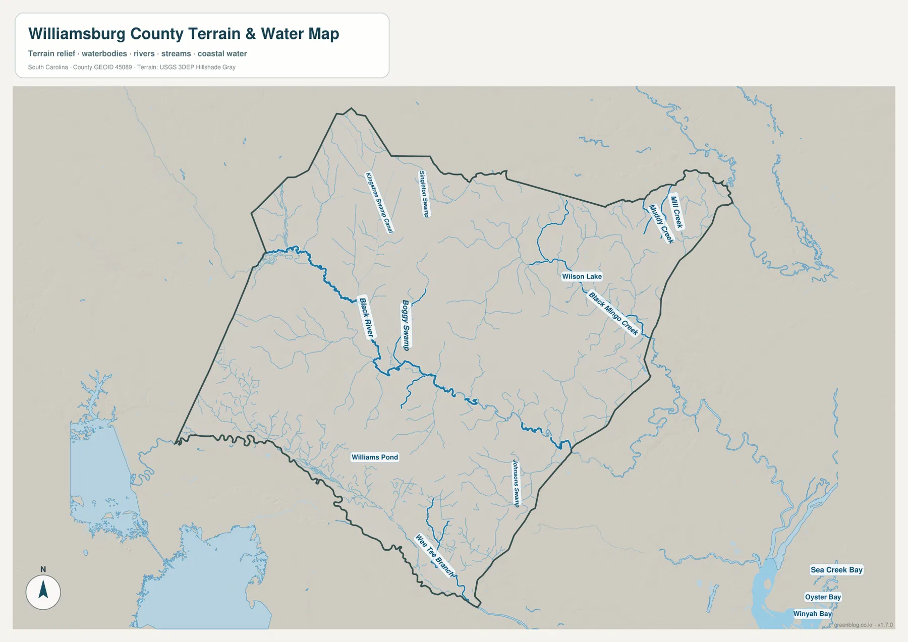
The terrain-and-water map has a very different visual center. The Black River enters from the western side and follows a long, winding course through the county toward the southeast. On the road map, Kingstree and the numbered highways dominate the view. On the water map, the Black River becomes the main reference line, with many smaller tributaries feeding into the broader drainage system.
Boggy Swamp is labeled north of the river, while Kinsman Swamp Canal and Singleton Swamp appear farther north. These names matter because the county’s water pattern is not made up only of conventional rivers and creeks. Swamp channels and wetland corridors are prominent map features, especially in the northern and central sections. The shaded terrain remains relatively gentle, so drainage lines stand out more strongly than steep ridges or major elevation breaks.
Wilson Lake and Black Mingo Creek add a separate eastern water pattern
Wilson Lake is one of the clearest named water bodies in the eastern half of the county. Black Mingo Creek runs southeast from that general area, while Muddy Creek and Mill Creek are labeled closer to the northeastern tip. After locating Hemingway and Stuckey on the road or city map, switching to the water map reveals that the same eastern section is organized by a different set of natural reference points.
The southern half introduces still more variety. Johnsons Swamp is labeled toward the southeast, Wee Tee Branch appears near the lower part of the county, and Williams Pond is marked farther west. These features are easier to remember when grouped by part of the county rather than treated as one long list. The map also shows Winyah Bay, Sea Creek Bay, and Oyster Bay outside the county in the far southeast as regional water context; they should not be mistaken for water bodies inside the Williamsburg County boundary.
Gentle relief makes streams and swamps more visible than elevation changes
The shaded background is subdued compared with maps of mountainous South Carolina counties. There are surface variations, but no sharp ridge system dominates the supplied view. Instead, the dense network of small streams, swamp channels, and branches becomes the stronger geographic signal. The Black River corridor and the many shorter waterways are therefore more useful for understanding this map than trying to identify high and low points from the hillshade alone.
Exact elevations require dedicated elevation data, and this preview should not be treated as a survey or engineering product. Its strength is showing relative terrain together with named water features. That makes it a useful companion to the road map: one image explains where the communities and highways are, while the other shows how those places sit among rivers, swamps, creeks, and ponds.
Start with a community, add the road network, then check the surrounding water
A practical sequence begins with the city-distribution map when the question is simply where a place lies. Once Kingstree, Hemingway, Lane, Greeleyville, or Stuckey is located, the general county map adds the relevant numbered routes and nearby communities. The terrain-and-water map is the final step when the Black River, a swamp, a creek, or a lake is part of the question.
The WebP images in the article are optimized for quick browser viewing. For printing, classroom material, reports, or larger layouts, the ZIP archive contains the matching high-resolution A3 JPG originals. The three files emphasize different information, so a reader can choose the road-and-place map, the ranked city map, or the terrain-and-water map without forcing every detail into one image.
These maps are general geographic references rather than live-navigation, legal-boundary, parcel, flood-risk, or engineering products. Travel conditions may change, legal boundaries must be checked against authoritative records, and the shaded relief is not intended to supply exact elevations. Use current official sources whenever a decision depends on those details.
Frequently Asked Questions
Which map is best for comparing Kingstree with Hemingway?
The city-distribution map is the quickest choice because Kingstree and Hemingway are easy to separate without the full road network. After locating Hemingway east of Kingstree, switch to the general map to add routes 51, 41, 512, and 261.
Where can I see the Black River and the named swamps?
Use the terrain-and-water map. The Black River crosses the county from the western side toward the southeast, while Boggy Swamp, Kinsman Swamp Canal, and Singleton Swamp are labeled farther north. Wilson Lake and Black Mingo Creek are visible in the eastern half.
What is included in the downloadable ZIP?
The archive contains three high-resolution A3 JPG files corresponding to the page previews: the general county road map, the ranked city-distribution map, and the terrain-and-water map. The WebP images in the article are lighter versions intended for browser viewing.
Map File Information
Download the Williamsburg County road map, ranked city map, and terrain-and-water map together as high-resolution A3 JPG files.
- Included Files: 3 JPG maps
Related Maps
Sources and Reference Data
- U.S. Census Bureau TIGER/Line Shapefiles: county boundaries, roads, and geographic reference data
- USGS National Hydrography: rivers, streams, wetlands, and hydrographic reference data
- USGS 3D Elevation Program: terrain and elevation reference data
- South Carolina Association of Counties: county information reference
Green Map creates custom-edited map images using open geographic data sources such as geoBoundaries, Natural Earth, OpenStreetMap, and government open data.
These maps are edited visual materials, not raw data files, and are provided for education, documents, presentations, and graphic reference.