North Slope Borough covers a vast part of northern Alaska, combining a long Arctic-facing coastline with a broad interior crossed by rivers and rugged terrain. The supplied county map places Point Hope at the far western end, then shows Point Lay, Wainwright, and Utqiaġvik along the northern coast. Atqasuk lies inland from the coast, Anaktuvuk Pass sits close to the southern boundary, and Prudhoe Bay is marked far to the east. This page follows only the places, roads, waterways, and terrain visible in the supplied map package. High-resolution JPG versions of the same maps are available to download together in the ZIP box below.
The borough is easier to understand when the coastal settlements and the interior are viewed together. The shoreline communities are separated by long distances, while the interior is filled with blue river lines that extend north from higher ground near the southern side of the borough. On the terrain-and-water map, the Kokolik, Utukok, Meade, Kogru, Colville, and Sagavanirktok rivers are among the clearly labeled features. The city-index map simplifies the picture by highlighting six communities, making it useful for comparing settlement locations before returning to the denser general and water maps.
Table of Contents
A long coast stretches from Point Hope past Utqiaġvik toward Prudhoe Bay
The general county map emphasizes the borough’s enormous east-west span. Point Hope is located on the far western side, Point Lay is farther east, and Wainwright appears along the northwest coast before the map reaches Utqiaġvik. The coastline then continues a long distance toward Prudhoe Bay on the eastern side. The settlements are small points within a much larger boundary, and the spaces between them contain many streams and rivers rather than a dense road network.
Atqasuk is positioned inland and south of the Utqiaġvik-Wainwright coast. Anaktuvuk Pass is much farther south, close to the borough’s interior boundary, which gives it a very different map position from the coastal communities. Outside the boundary, labels such as Wiseman, Coldfoot, Arctic Village, and Red Dog Mine help with regional orientation. They are useful reference points, but they are not evidence that those places belong to North Slope Borough.
Near Prudhoe Bay, an orange road line runs south from the coast and the map shows an 11 route shield. That feature provides a useful visual reference for the eastern part of the borough and its connection toward the interior. The map should not be read as a live road-condition product, however. It does not provide current travel times, closures, seasonal access, or surface conditions, so those questions require a current transportation source rather than this static reference map.
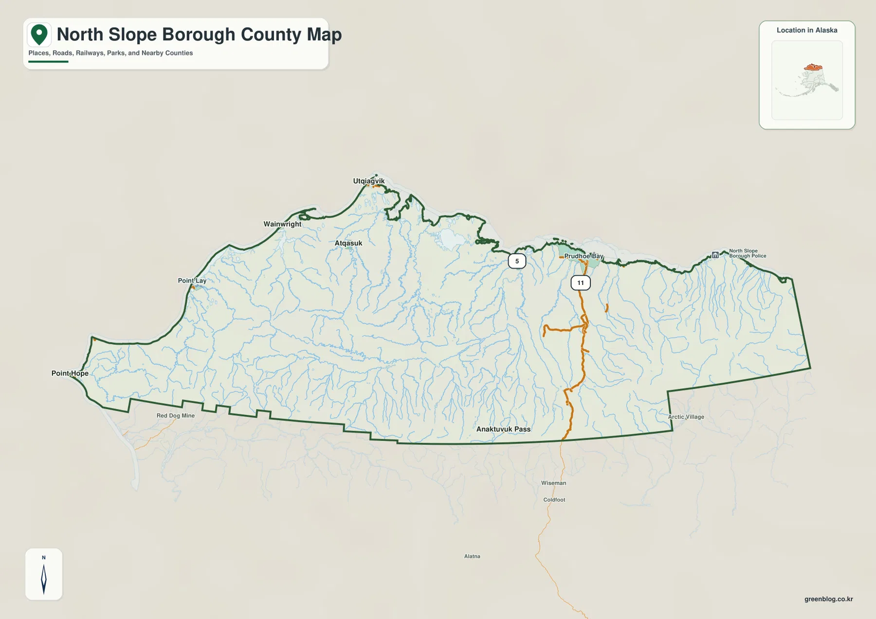
The general map is most useful when the goal is to see the entire borough in one frame. It allows a reader to compare the western coast with the Utqiaġvik area, locate Anaktuvuk Pass in the interior, and see Prudhoe Bay on the eastern side. It is not intended for parcel research, legal boundary determination, or detailed street navigation. For a formal boundary or coordinate question, the U.S. Census Bureau’s official geographic files are a better source.
The city index highlights six communities spread across coast and interior
The city-index map removes many secondary labels and ranks six highlighted communities: Utqiaġvik, Point Hope, Wainwright, Nuiqsut, Anaktuvuk Pass, and Atqasuk. Their positions show how dispersed settlement is across the borough. Utqiaġvik and Wainwright sit near the northwest coast, Point Hope is far to the west, Nuiqsut is farther east and inland, Atqasuk is inland from the northern coast, and Anaktuvuk Pass is placed close to the southern boundary.
The CITY INDEX panel prints values of 4,778 for Utqiaġvik, 832 for Point Hope, 718 for Wainwright, 416 for Nuiqsut, 329 for Anaktuvuk Pass, and 288 for Atqasuk. Those are values shown directly on the supplied image and can be described as part of the map. They should not automatically be treated as the latest official population counts, because the map itself does not establish that they represent the newest Census release. Anyone who needs current population data should check the most recent Census source separately.
Names outside the borough, including Yukon-Koyukuk Census Area, Northwest Arctic Borough, and Nome Census Area, help frame North Slope Borough within northern and western Alaska. The city map is not designed to measure adjacent boundaries or calculate distances between jurisdictions. Its main advantage is simplicity: the six numbered labels make it easier to understand where the selected communities are located before comparing them with the river network or the full county map.
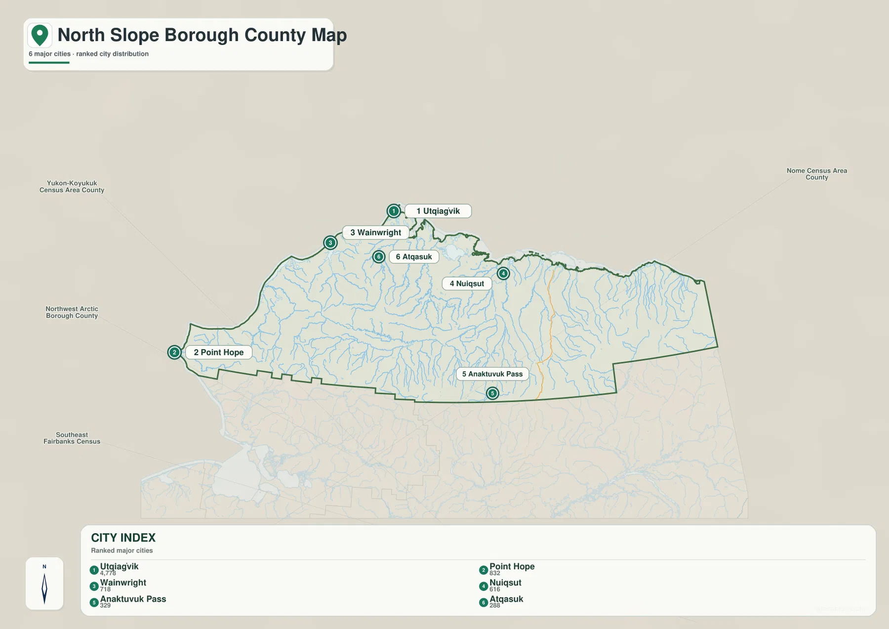
For a quick location comparison, this simplified version is the easiest of the three maps to read. Point Hope is visibly isolated at the western end, Wainwright and Utqiaġvik occupy the northwest coast, Atqasuk sits inland, Nuiqsut lies farther east, and Anaktuvuk Pass is far to the south. When the question shifts from settlements to rivers or terrain, the city map becomes too sparse and the terrain-and-water map provides the missing context.
Major rivers run north across the borough from higher southern terrain
The terrain-and-water map changes the emphasis completely. In the western part of the borough, the Kokolik River and Utukok River are clearly labeled as they extend toward the coast. Farther east, the Meade River is marked, and the Kogru River appears closer to the central northern area. The Colville River and Sagavanirktok River dominate the eastern half of the map with long, recognizable channels. Numerous smaller streams fill the spaces between the named rivers.
Relief shading becomes stronger near the southern boundary, where the landscape is drawn with more pronounced ridges and valleys. Moving north toward the coast, the terrain appears broader and less rugged while rivers branch across the surface. The map does not contain surveyed elevation numbers, so it should be used to compare general relief rather than to calculate exact heights or slopes. Precise elevation work requires a dedicated elevation dataset such as the USGS 3D Elevation Program.
Several large regional water labels appear outside the borough in the lower-left part of the map, including Chukchi Sea, Hotham Inlet, Kotzebue Sound, Shishmaref Inlet, Selawik Lake, and Eschscholtz Bay. These labels provide regional orientation and should not be confused with waterways located inside the borough boundary. Keeping the internal river names separate from surrounding regional water bodies prevents the map from being interpreted too broadly.
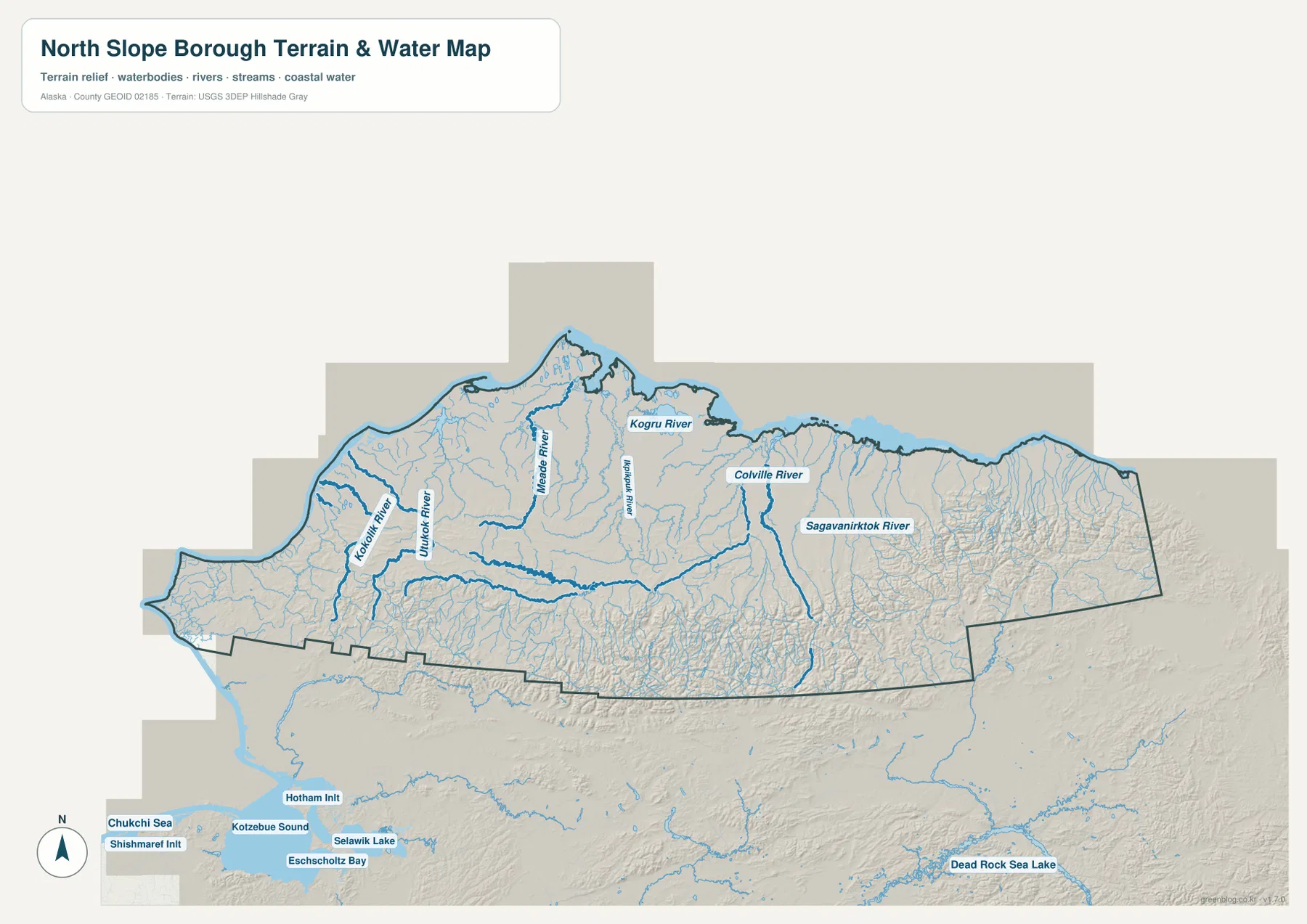
This water map is a geographic reference, not a flood-risk, navigation, ice-condition, parcel, or legal-water-boundary product. It can show where major rivers are located and how the terrain changes across the borough, but it cannot answer questions about water depth, seasonal freezing, travel safety, or current river conditions. Those questions require current specialized information from the responsible agencies.
Coastal settlements and the southern interior create the borough’s strongest map contrast
Viewed together, the maps reveal a clear contrast between the northern coast and the southern interior. Point Hope, Point Lay, Wainwright, Utqiaġvik, and Prudhoe Bay form a loose chain of widely separated coastal locations, while Atqasuk is set inland and Anaktuvuk Pass is far south. The city index reinforces the same pattern with its six numbered communities. Settlement is therefore not represented as one continuous urban belt but as scattered places separated by large areas of rivers and open terrain.
The water map explains much of the area between those settlements. Major rivers extend from the south toward the north, and many smaller channels are visible between them. The western Kokolik and Utukok systems look different from the broader eastern Colville and Sagavanirktok rivers, while the relief shading becomes more rugged near the southern edge. These are visible map differences rather than claims about land use, ownership, climate, or current accessibility.
Frequently Asked Questions
Where are Utqiaġvik, Point Hope, and Wainwright on the map?
All three are on the northern or western side of the borough, but they are widely separated. Point Hope is at the far western end, Wainwright is farther east along the coast, and Utqiaġvik is still farther east on the northern coast. The city-index map makes their relative positions especially easy to compare.
Why does Anaktuvuk Pass look different from the other highlighted communities?
Anaktuvuk Pass is highlighted in the city index but sits close to the southern interior boundary rather than the Arctic-facing coast. That gives it a very different map position from Point Hope, Wainwright, and Utqiaġvik. The county and city maps together make this inland-versus-coastal contrast clear.
Which rivers are labeled on the terrain-and-water map?
The supplied map clearly labels the Kokolik River, Utukok River, Meade River, Kogru River, Colville River, and Sagavanirktok River. The map is useful for geographic reference and general terrain comparison, but it is not a flood map, navigation chart, or source for current river and ice conditions.
Map File Information
Download the map files associated with this page for reference, printing, and compatible visual projects.
- Included Files: Three high-resolution JPG maps: county, city index, and terrain-and-water
- File Type: JPG files in one ZIP archive
- Intended Use: Printing, education, presentations, and map-based projects
Related Maps
Sources and references
Official administrative boundary data are available from the U.S. Census Bureau TIGER/Line Shapefiles. Water-network reference data are available through USGS National Hydrography, and detailed elevation data are available from the USGS 3D Elevation Program. The geographic descriptions on this page are based on features visible in the supplied North Slope Borough map package.
Green Map creates custom-edited map images using open geographic data sources such as geoBoundaries, Natural Earth, OpenStreetMap, and government open data. These maps are edited visual materials, not raw data files, and are provided for education, documents, presentations, and graphic reference.