Blount County, Tennessee, changes character quickly from the Maryville–Alcoa urban area in the northwest to the steep mountain country on its southeastern side. The maps on this page make that contrast easy to see: communities and roads are concentrated around Maryville, Alcoa, Louisville, Friendsville, and Rockford, while Little River and a dense network of mountain streams lead toward Townsend and the Smokies. You can download the same four-map set directly from this page as one ZIP containing high-resolution A3 JPG files for printing, annotation, or offline reference.
A useful way to understand the county is to start with the settled northwest and then move southeast. Maryville is the county seat and the strongest city label, with Alcoa immediately to the north. Louisville, Friendsville, and Rockford fill out the northwestern cluster, while Townsend sits well to the east near the mountain front. The water and elevation maps explain the spacing: broad lower terrain around the main cities gives way to narrow valleys, rising ridges, and much higher country toward the Great Smoky Mountains.
Each map emphasizes a different part of that story without requiring a technical GIS background. The general county map is best for roads and named places, the city map isolates the six ranked communities, the terrain-and-water map traces Little River and its tributaries, and the elevation map shows how dramatically the ground rises across the county. Used together, they provide a practical picture of where people live and how the landscape changes around them.
Table of Contents
Maryville and Alcoa anchor the road network
The general county map makes the Maryville–Alcoa area the clearest transportation center in Blount County. Maryville sits near the northwestern half of the county, and Alcoa is immediately north of it. Roads fan outward toward Louisville and Friendsville on the west, Rockford on the north, Wildwood and Walland on the east, and Townsend farther toward the mountains. Compared with the southeastern half of the county, this area contains far more named communities and a visibly denser road pattern.
Several numbered routes make the pattern easier to follow. US 321 carries traffic east from the Maryville area through Walland toward Townsend. US 411 reaches the northeastern side of the county, while US 129 and SR 115 extend southward from the urban core. SR 33, SR 333, and SR 336 help connect western and southwestern parts of the county. The map is not a turn-by-turn road product, but it is detailed enough to show which side of Maryville a community lies on and which major route leads in that direction.
Names just beyond the boundary also provide useful orientation. Seymour appears near the northeastern edge, while Greenback and Lenoir City lie west of the county. Those labels help show that the regional road network continues across county lines rather than stopping at the mapped boundary. For any place close to the edge, the dark county outline should be checked before assuming that a nearby town or road segment is actually inside Blount County.
Six mapped communities reveal a northwest-heavy settlement pattern
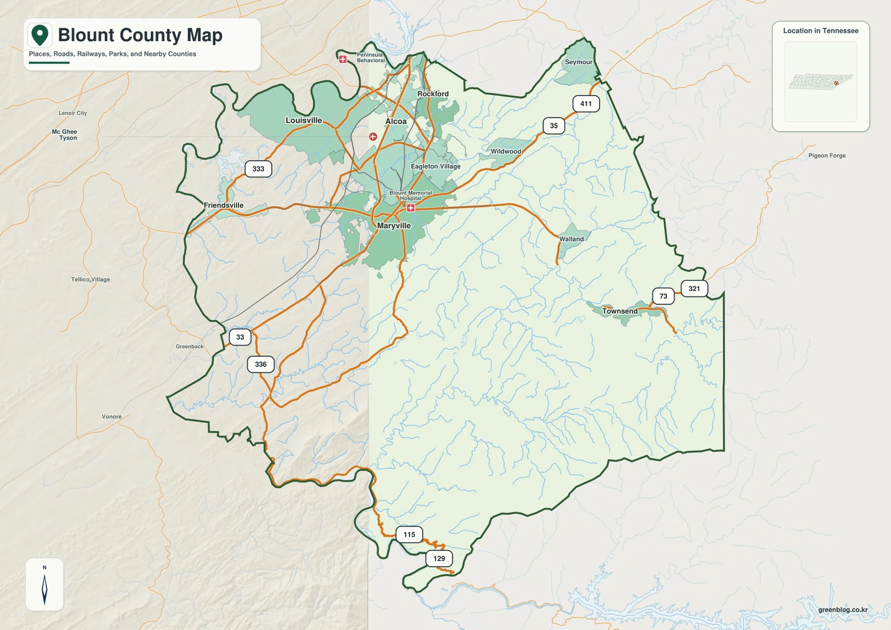
The city map strips away much of the background detail and ranks six major communities: Maryville, Alcoa, Louisville, Friendsville, Rockford, and Townsend. Five of the six are grouped in the northwestern part of the county. Maryville and Alcoa form the strongest pair, while Louisville, Friendsville, and Rockford occupy nearby positions around them. Townsend stands apart to the east, close to the area where the terrain begins to rise sharply.
That arrangement matters more than the rank numbers alone. It shows that Blount County is not organized around evenly spaced towns. The principal settled area is concentrated around a lower, better-connected part of the county, whereas the southeastern landscape contains fewer mapped population centers. When the city map is compared with the elevation surface, the contrast between the northwestern community cluster and the mountain interior becomes especially clear.
The CITY INDEX is useful for quick relative comparison, but it should not be treated as a live population dashboard. For current population work, the Census Bureau should be checked separately. On this page, the main value of the city map is positional: it makes it immediately obvious which communities form the urban cluster and how far Townsend is separated from that cluster by the county’s changing terrain.
Little River connects the mountain interior to lower waters
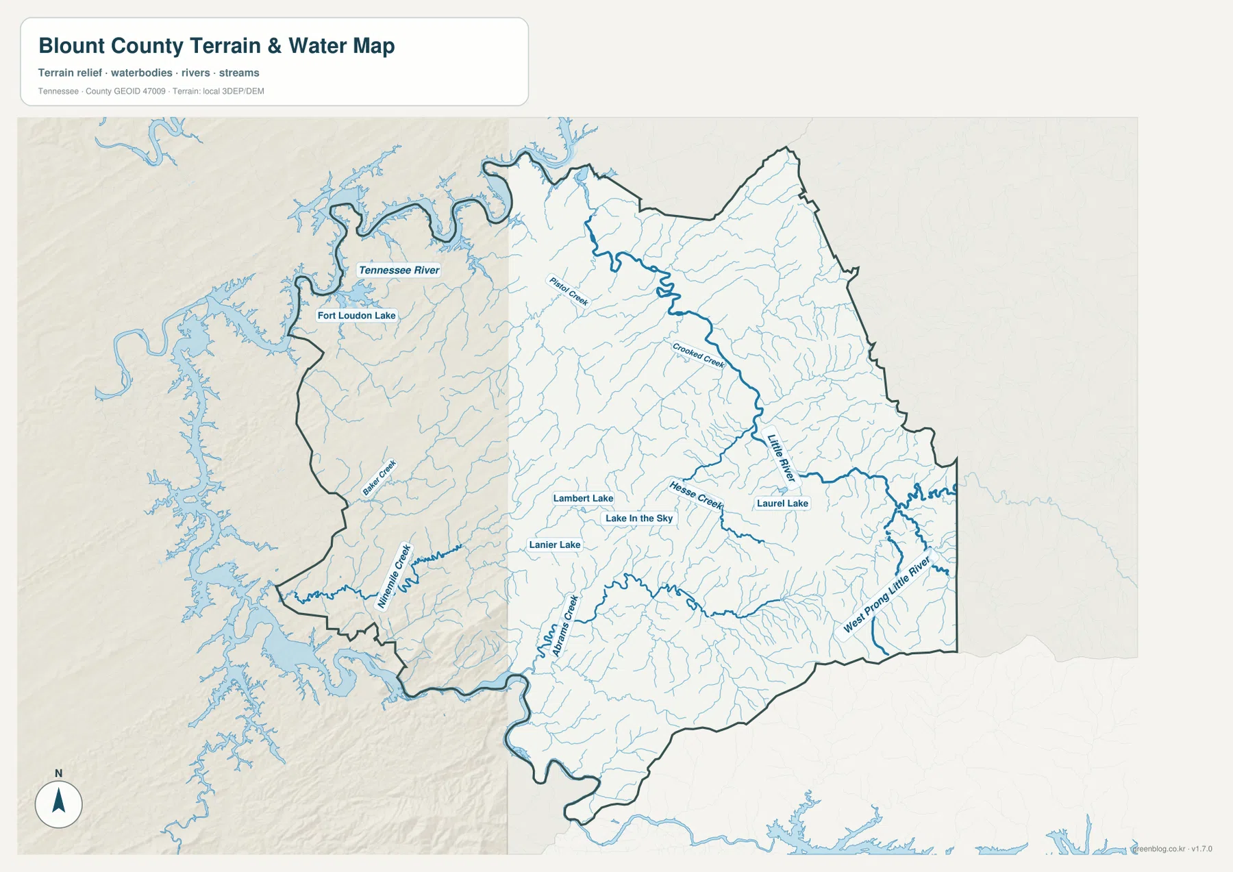
Water is easiest to interpret on the terrain-and-water map. At the northwestern edge, the Tennessee River and Fort Loudoun Lake form the largest water feature near the county. Inside Blount County, Pistol Creek is visible near the Maryville area, while Crooked Creek and Little River form stronger lines farther east. Little River becomes the key reference because it runs across the county from the mountain side toward the lower settled area.
The southeastern drainages are more intricate. West Prong Little River is labeled near the eastern edge, Abrams Creek appears farther south, and many smaller tributaries fill the narrow valleys between ridges. Ninemile Creek and Bakers Creek are visible in the southwest, while Hesse Creek and other branches join the central-eastern network. Several smaller named lakes—Lambert Lake, Lanier Lake, Lake in the Sky, and Laurel Lake—provide additional local landmarks.
This water map is best used to compare drainage direction, named streams, lakes, and the relationship between waterways and terrain. It is not a flood-hazard map, navigation chart, or legal water-boundary document. Someone researching flood exposure, boating restrictions, or parcel boundaries should use the appropriate current agency data. For county-scale orientation, however, the map clearly shows why the eastern half contains so many stream branches and why Little River is such an important geographic reference.
Elevation rises from about 206 meters to 1,675 meters
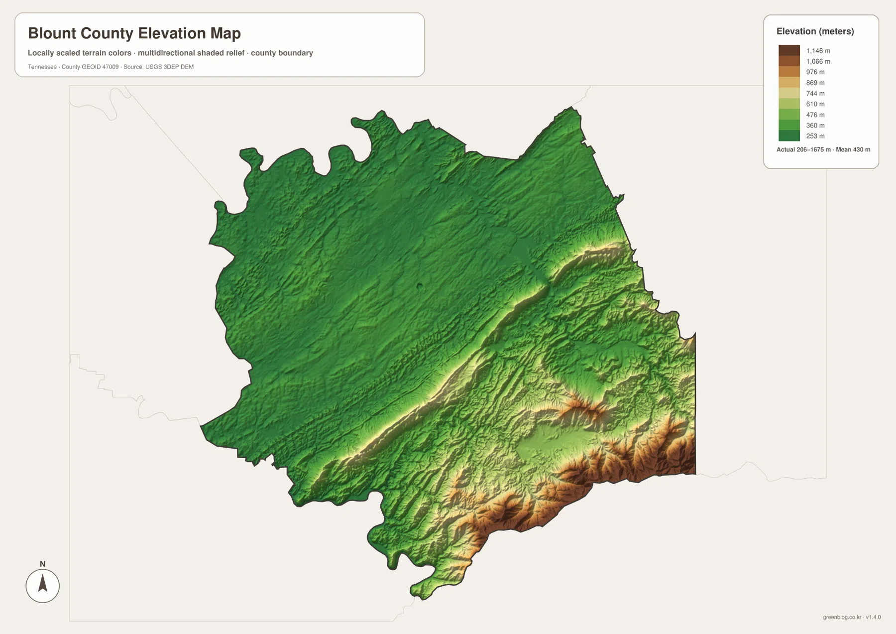
The elevation map shows the most dramatic physical contrast in the county. Its actual mapped range is about 206 to 1,675 meters, with a mean near 430 meters. Much of the northwestern section is shaded in lower green tones, which fits the broad area containing Maryville, Alcoa, Louisville, and Friendsville. Moving southeast, the colors change rapidly through lighter greens and yellows into browns as long ridges and mountain slopes become dominant.
A prominent ridge belt cuts across the central-to-southeastern part of the county, separating the lower urban side from more rugged terrain. Beyond it, multiple ridges overlap, valleys narrow, and the highest elevations appear along the southeastern margin. Townsend’s location near this transition is therefore important: on a road map it may simply look like another eastern community, but on the elevation map it sits much closer to the mountain landscape than Maryville or Alcoa.
The shaded surface is intended for regional comparison, not engineering measurement. It is excellent for seeing where low terrain ends, where ridges begin, and how the southeastern portion differs from the settled northwest. It should not be used to assign an exact survey elevation to a property, structure, or road. For detailed elevation analysis, USGS source data or site-specific measurements are the better choice.
County edges connect Knoxville-side communities with Smoky Mountain country
Blount County borders Knox County to the north and Sevier County to the east, while Loudon and Monroe counties lie to the west and southwest. The southeastern boundary reaches the mountain region next to North Carolina. This creates two very different kinds of county edge: the northwest is tied into a broader road-and-community network, while the southeast is dominated by ridges, streams, and protected mountain land.
The general map makes that difference visible even before the elevation colors are added. Around Maryville and Alcoa, roads and named places approach the county line from several directions. In the southeast, the map contains far fewer settlement labels, yet the water map fills the same area with branching streams and the elevation map fills it with steep relief. Blank space on a city map therefore does not mean the land lacks geographic detail; it means the dominant features there are mountains and drainage rather than towns.
The 2020 census counted 135,280 residents in Blount County, and the Census Bureau’s July 2025 estimate is 143,820. Those county totals are useful for scale, but the maps show why a single density figure cannot describe where people are actually concentrated. The Maryville–Alcoa cluster occupies a relatively small part of the county, while a broad southeastern area is mountainous and much less densely labeled with communities.
Choose the map that matches the question
For a first look at Blount County, the general map is the most versatile because it combines communities, major roads, the county outline, and nearby reference places. The city map is faster when the only question is where the main communities sit relative to one another. The water map is the better choice for Little River, Fort Loudoun Lake, and tributary names, while the elevation map is the clearest way to explain the sharp climb toward the Smokies.
For printed work, it is often better to use two maps rather than crowd every subject onto one sheet. A road-and-city annotation can stay on the general map, while stream names or terrain notes can be kept on the specialized map. The elevation file benefits from color printing because the low-to-high transition is encoded with color as well as relief. All four files cover the same county but answer different practical questions.
Frequently Asked Questions
Why are Maryville and Alcoa both important on the county map?
Maryville is the county seat and the main geographic anchor, while Alcoa is a large neighboring city immediately to the north. Seeing them together explains the strongest urban concentration in Blount County. Adding Louisville, Friendsville, and Rockford shows how much of the mapped community network is packed into the northwest compared with the mountain side of the county.
Which map should I use to follow Little River?
The terrain-and-water map is the best choice because it labels Little River along with West Prong Little River, Crooked Creek, Pistol Creek, Abrams Creek, and numerous smaller tributaries. The general map provides broader orientation, but the water map makes stream branches and their relationship to the valleys much easier to distinguish.
What does the elevation map show about the Smokies side of Blount County?
It shows a very large rise from the lower northwestern part of the county into the southeast. The mapped actual range is about 206 to 1,675 meters, and the highest terrain is concentrated along the southeastern mountain margin. This explains why the landscape around Townsend and farther southeast is far more rugged than the Maryville–Alcoa area.
Map File Information
Download the Blount County county, city, water, and elevation maps together as a ZIP containing four high-resolution A3 JPG files.
- Included Files: County, city, water, and elevation maps
- File Type: ZIP with four JPG files
Related Maps
- Lewis County Tennessee map | Hohenwald and Natchez Trace
- Bedford County Tennessee Map
- Bledsoe County Map
Sources and references
County boundaries and geographic reference data can be checked through U.S. Census Bureau TIGER/Line. Current population figures are available from U.S. Census Bureau QuickFacts for Blount County, Tennessee.
For road information, see the Tennessee Department of Transportation SR 115/US 129 Alcoa Highway project page. Water references can be checked with USGS National Hydrography, and elevation source information is available from the USGS 3D Elevation Program. Historical county background is also available through the Tennessee State Library and Archives Blount County fact sheet.
Green Map creates custom-edited map images using open geographic data sources such as geoBoundaries, Natural Earth, OpenStreetMap, and government open data. These maps are edited visual materials, not raw data files, and are provided for education, documents, presentations, and graphic reference.