Worth County sits in southwest Georgia with Sylvester as the clearest road and community hub on the maps. Poulan and Sumner lie to the east of Sylvester, while Warwick is much farther north near the top of the county. The page brings together four views of the same county—general location, city connections, water, and elevation—so a reader can move from roads and communities to creek valleys and terrain without trying to crowd every detail into one image. All four maps are also available as high-resolution A3 JPG files in one downloadable ZIP.
The existing county material describes Worth County as an 1853 county with a regional background tied to peanut production, agriculture, forestry, food processing, and access toward the Albany area. Those facts help explain the county’s rural setting, but the maps on this page are not crop or land-cover maps. The discussion below therefore separates background information from what can actually be seen: incorporated places, major roads, county boundaries, named streams, ponds, and changes in elevation.
Table of Contents
Sylvester as the Main Reference Point
The general county map makes Sylvester the easiest place to orient yourself. It is the county seat and sits a little south of the county’s midpoint, where several important routes meet. From Sylvester, the map carries east through Poulan toward Sumner, while another long connection runs north toward Warwick. That simple arrangement gives Worth County a recognizable structure: one central hub, two smaller incorporated places close together to the east, and a separate northern town.
Several numbered roads reinforce that pattern. Routes 33 and 313 form a strong north-south line through or near Sylvester, while 520 and 82 continue east through Poulan and toward Sumner. Farther north, 32 and 300 are visible across the upper part of the county. In the south, 112, 133, and 256 lead toward neighboring areas. The map is not intended to replace a turn-by-turn road map, but it gives enough detail to understand which parts of Worth County connect directly through Sylvester and which communities sit farther from that core.
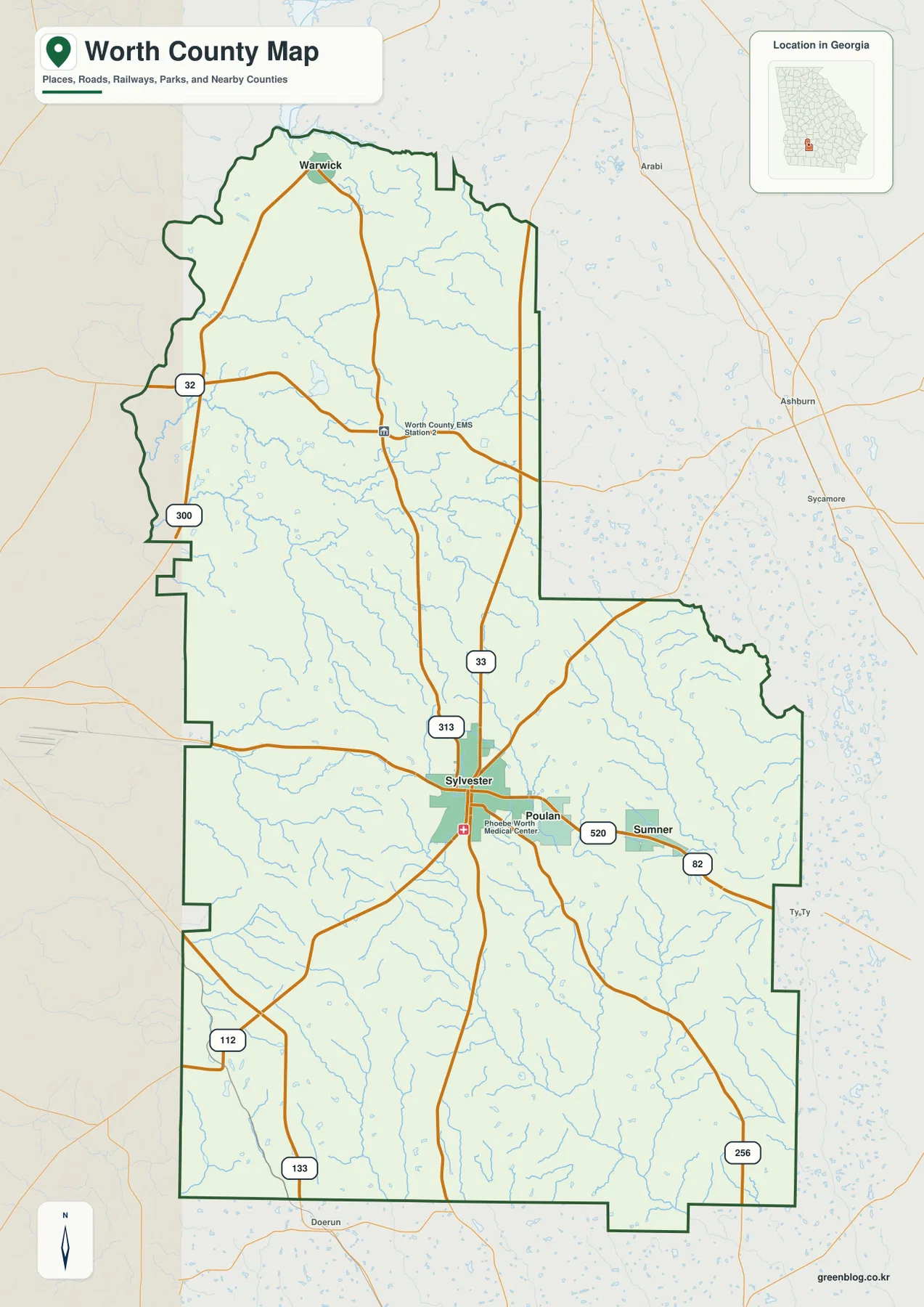
A few local service labels appear near Sylvester as well, but the broader value of this map is geographic orientation. For a report, classroom handout, or family-history project, the most useful first step is to locate Sylvester and then trace the direction to Warwick, Poulan, or Sumner. Once that framework is clear, the water and elevation maps become much easier to interpret.
A Dispersed Town Pattern from Warwick to Sumner
The city-focused map strips away some of the extra labels and makes the spacing between the four incorporated places more obvious. Sylvester and Poulan are close enough to read as a central pair, while Sumner extends that chain farther east. Warwick is different: it stands well north of the other three and is reached along a longer north-south route. This matters when a reader is trying to understand county scale. Worth County is not a compact cluster of towns surrounding one downtown; its incorporated communities occupy noticeably different parts of a long county.
The surrounding county labels add another layer of context without turning the map into a regional atlas. Lee and Dougherty counties appear to the west, while Turner and Tift are shown to the east. Mitchell and Colquitt frame the southern side. Together, those labels place Worth County between the Albany side of southwest Georgia and the Tift–Colquitt side farther east. The city map is especially helpful when the question is not “Which road should I take?” but “Where is this place within the county, and which direction leads toward neighboring counties?”
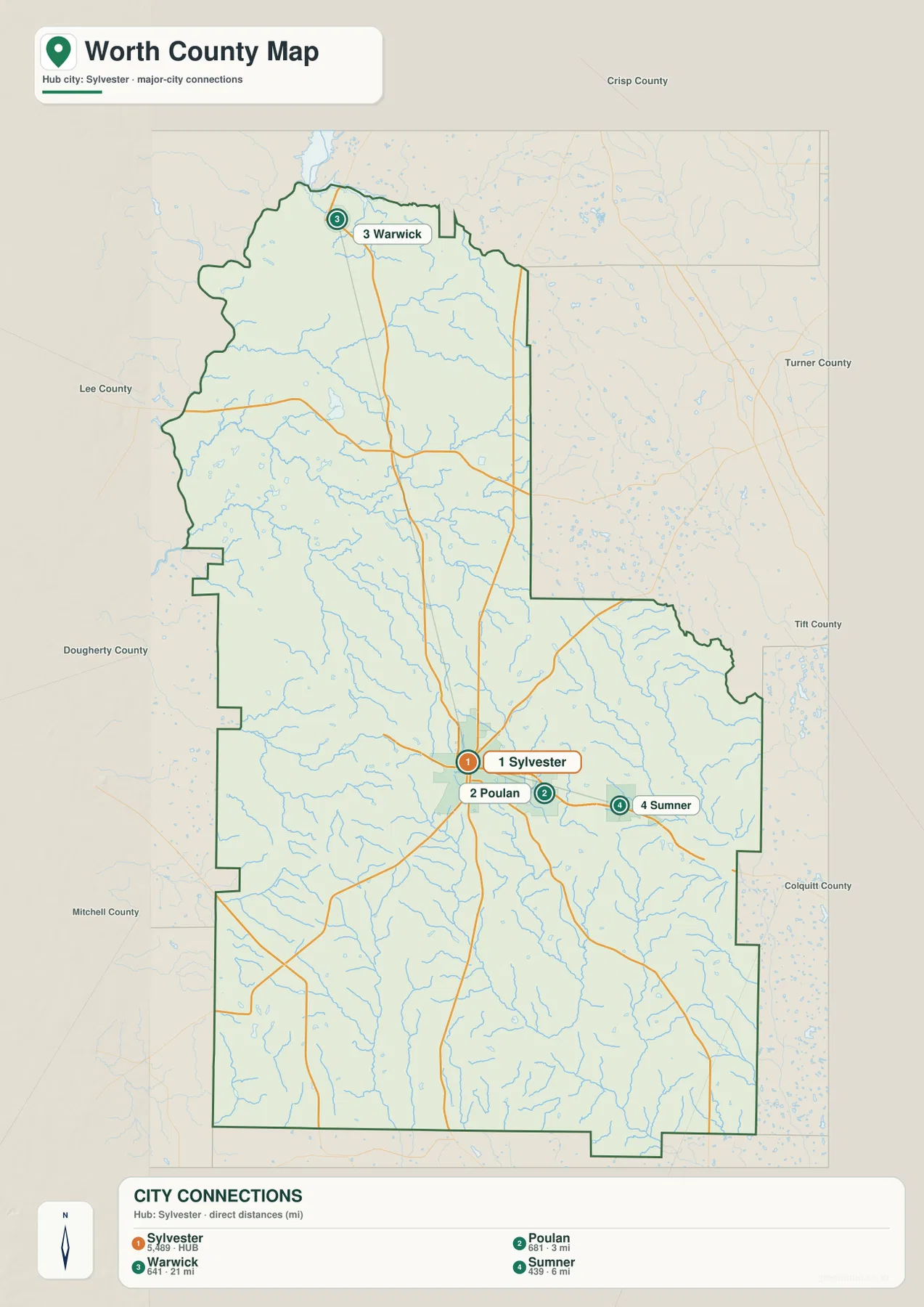
This view is also a good reminder that a city map is selective. It highlights the incorporated places used in the county set and does not attempt to label every rural community, church, crossroads, farm road, parcel, or service location. For detailed navigation or property research, a more specialized source is required. For county orientation, however, the simplified placement of the four towns is one of the strongest features of the map set.
Creeks Across the County and the Ochlockonee Drainage
The water map changes the character of Worth County almost completely. With the road network removed, a dense web of small streams becomes visible. Swift Creek and Jones Creek are labeled in the northern part of the county, and Abrams Creek crosses a large section of the northwest. Mill Creek is also shown on that side. Farther east and south, Ty Ty Creek and Little Creek form additional drainage lines, while Warrior Creek and the Little Ochlockonee River become important in the southern half.
The main lesson is not that one giant river dominates the county. Instead, numerous smaller channels occupy separate valleys and eventually feed larger drainage systems. The Ochlockonee River and Little Ochlockonee River labels in the south make that pattern especially clear. Small ponds and millponds are scattered among the creek network as well. This map should not be used as a flood-zone or legal stream-boundary document, but it works well for identifying named water features and understanding how widespread surface drainage is across rural Worth County.
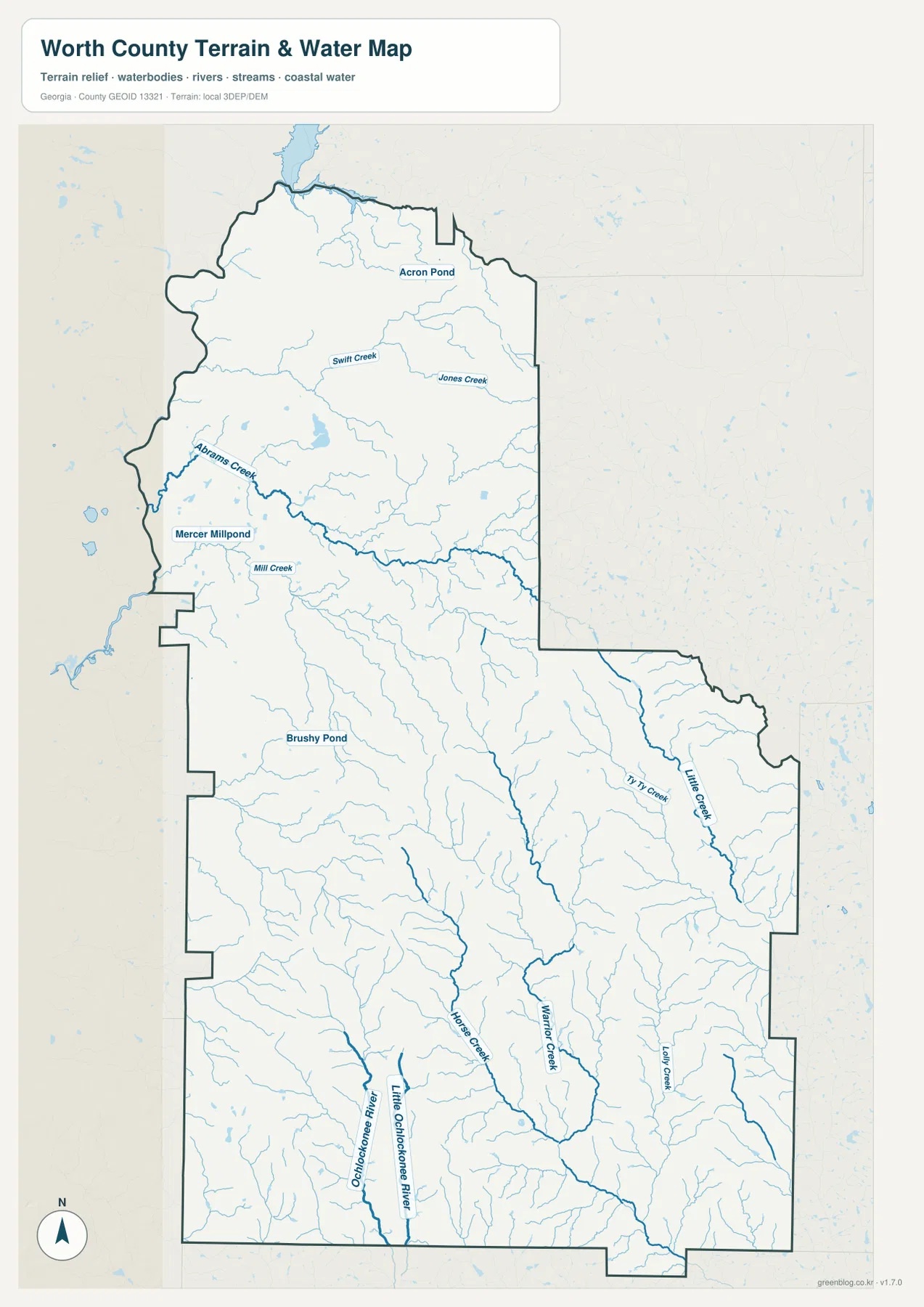
Comparing this map with the city view is useful because the streams do not follow the simple straight-line relationships between towns. Around Sylvester and Poulan, many short tributaries occupy the countryside between the road corridors. Toward the south, longer channels become more prominent. That difference helps explain why the elevation map shows so many narrow low areas cutting through otherwise higher ground.
Rolling Ground Between About 58 and 139 Meters
The elevation map gives an actual county range of about 58 to 139 meters, with a mean near 100 meters. Those numbers describe modest relief rather than mountain terrain, yet the local differences are easy to see. Much of the north and west appears in lower green shades. Higher yellow and brown ground becomes more common through the central and southeastern parts of the county, with additional ridges in the southwest. The result is a landscape of broad rolling uplands separated by many shallow creek valleys.
The narrow green lines that cut through higher colors are especially important. They often line up with the drainage features seen on the water map, showing how creeks occupy lower ground. This relationship is more informative than the average elevation alone: a reader can see that two locations at similar regional height may still be separated by a small valley or ridge. Around the central part of the county, the pattern is a patchwork of low channels and higher ground rather than one uniform plain.
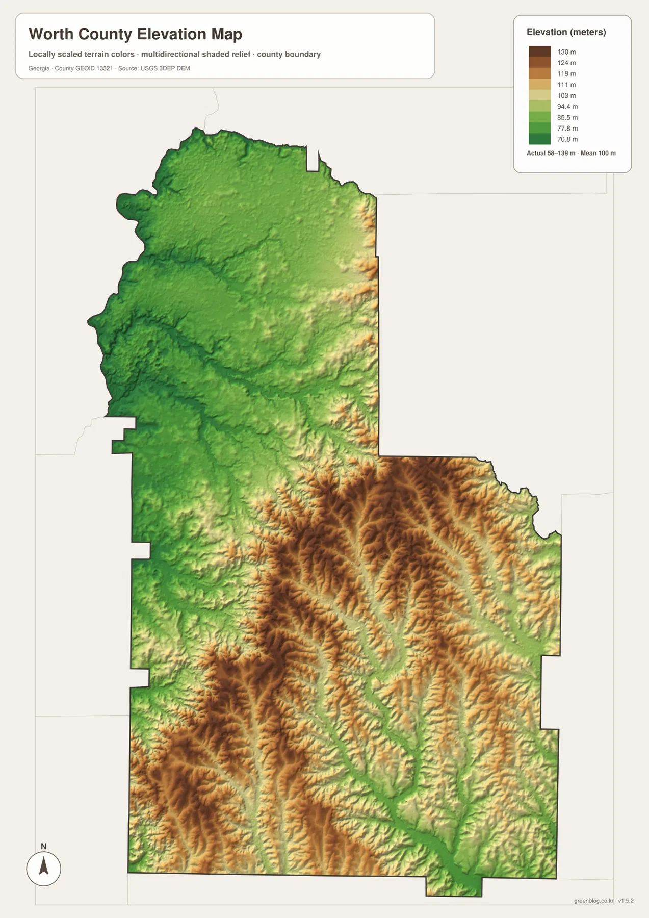
This terrain view also explains why the water network appears so intricate. Roads often aim for direct connections between Sylvester and other communities, but creeks follow the lower contours of the land and bend through valleys. Used together, the road map, water map, and elevation map show three different organizing systems within the same county: human travel, drainage, and relief.
Peanut Country as Background, Not a Mapped Land-Cover Claim
Worth County is commonly described in the supplied county material through peanut production, agriculture, forestry, and food processing. That context fits the rural road network and the broad area outside Sylvester, but readers should not treat the four maps here as a crop inventory. They do not classify fields by crop, show percentages of forest and agriculture, or draw farm-property boundaries. A field that appears as open background on a general map cannot be identified as a peanut field from this map alone.
A better way to use the set is to establish location first. Find Sylvester and the surrounding road corridors, use the city map to place Warwick, Poulan, and Sumner, then compare streams and terrain where needed. If the research question concerns crops, land cover, ownership, zoning, or flood risk, bring in a source designed for that subject. The Worth County map set provides the geographic framework rather than pretending to answer questions outside its data.
Choosing the Right Worth County Map for the Task
For a first look at Worth County, start with the general map because it combines the boundary, major roads, and the best-known incorporated places. Switch to the city map when town spacing and neighboring-county direction matter more than road detail. The water map is the better choice for named creeks and drainage, and the elevation map is useful when you need to explain why some valleys sit lower than the surrounding rolling ground. The maps are designed to complement one another rather than duplicate the same information four times.
The downloadable set is useful for printing, classroom work, local-history notes, presentations, and other situations where a larger image is easier to read than a webpage preview. Each file is provided as a high-resolution A3 JPG, and all four are packaged together in one ZIP.
Frequently Asked Questions
Why does Sylvester stand out on the Worth County maps?
Sylvester is the county seat and the clearest road hub in the map set. Poulan and Sumner lie east of it, while Warwick is much farther north, so Sylvester works well as the reference point for comparing the rest of the county.
What water features are easiest to identify?
Named features include Abrams Creek, Swift Creek, Jones Creek, Ty Ty Creek, Warrior Creek, and the Little Ochlockonee and Ochlockonee river system. The map also shows many smaller tributaries and several ponds.
What is included in the downloadable ZIP?
The ZIP contains four high-resolution A3 JPG files: the general county map, city map, water map, and elevation map. They are intended for larger viewing and printing than the lightweight webpage previews.
Sources and Reference Data
The county background and the map topics can be cross-checked with the following reference sources supplied with the rewrite package.
- U.S. Census Bureau Worth County QuickFacts
- New Georgia Encyclopedia: Worth County
- U.S. Census Bureau TIGER/Line Shapefiles
- USGS National Hydrography
- USGS 3D Elevation Program
Map File Information
Download the Worth County general, city, water, and elevation maps as high-resolution A3 JPG files.
- File Type: One ZIP containing four high-resolution A3 JPG files
Related Maps
Green Map creates custom-edited map images using open geographic data sources such as geoBoundaries, Natural Earth, OpenStreetMap, and government open data. These maps are edited visual materials, not raw data files, and are provided for education, documents, presentations, and graphic reference.