Wilkinson County sits in central Georgia, where a small group of towns is spread across a broad rural landscape rather than concentrated in one compact urban area. Gordon and Ivey occupy the northwest, McIntyre lies nearer the middle, Irwinton anchors the central-southern part of the county as the county seat, and Toomsboro is farther east. The maps on this page make those relationships easy to see while also showing the county boundary, major roads, numerous creeks and lakes, and a noticeable change from higher western hills to lower ground in the east.
You can also download the complete four-map set as a ZIP containing four high-resolution A3 JPG files. The county map is best for general orientation, the city map compares the five mapped communities, the water map focuses on creeks and named water bodies, and the elevation map shows how ridges and stream valleys change across the county. These are reference maps, not parcel, flood-hazard, mining-claim, or survey products, so specialized decisions should be checked against the appropriate official source.
Table of Contents
Roads and county shape from Gordon to Irwinton
The county map gives the clearest overall view of Wilkinson County. Gordon and Ivey sit close together in the northwest, while McIntyre and Irwinton occupy the middle portion of the map and Toomsboro lies to the east. Nearby places outside the county, including Hardwick to the north, Oconee to the east, and Danville and Allentown near the southern edge, provide useful orientation without crowding the county interior.
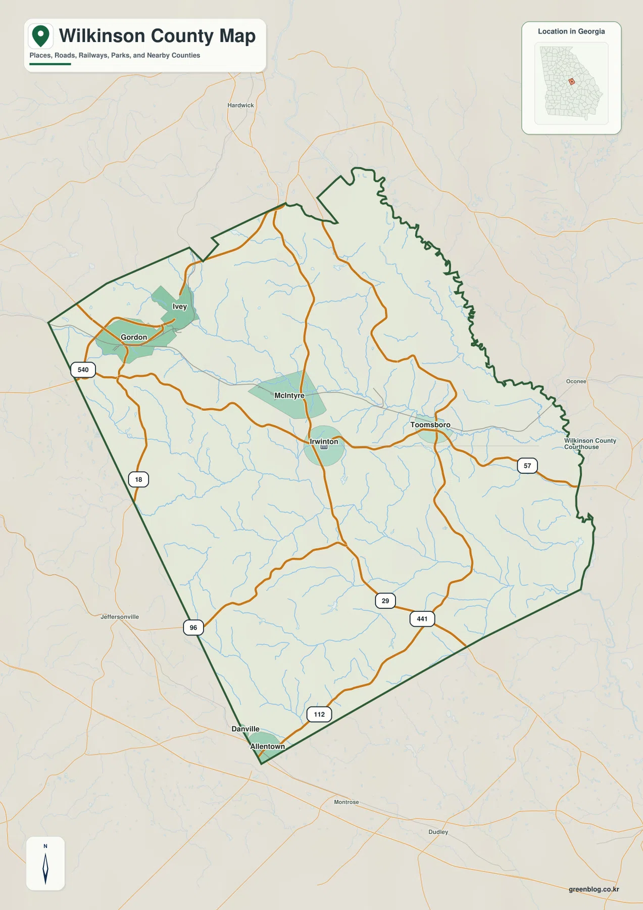
Several numbered roads help explain how the county is connected. Route 57 runs through the Irwinton-Toomsboro side of the county, while Route 18 and Route 96 appear along the western and southwestern portions of the map. Routes 29, 441, and 112 are marked in the southern half. The result is a road pattern in which the small communities are linked by a handful of important corridors rather than by a dense street grid.
The boundary itself changes character from one side to another. Long, straighter segments are visible along much of the west and south, while the northeastern and eastern edges are more irregular. That contrast makes it easier to distinguish the Gordon side of the county from the Toomsboro side when the map is used in a classroom, local-history project, or regional report.
Five mapped communities show a west-to-east settlement pattern
The city map is especially useful because it separates the five mapped communities and ranks them in the supplied city index. Gordon is listed first at 2,485, followed by Ivey at 964, McIntyre at 633, Irwinton at 534, and Toomsboro at 467. Those figures are the values printed on the supplied map, so they are best treated as the map’s own ranking reference rather than as a substitute for checking the latest population table.
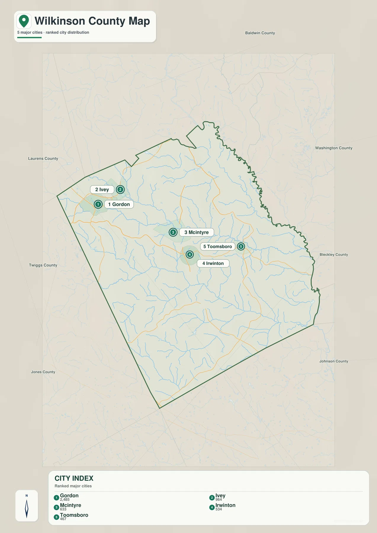
Gordon and Ivey form the closest pair on the map. McIntyre lies farther east, Irwinton sits south of McIntyre, and Toomsboro continues the sequence toward the eastern side of the county. This arrangement matters because Wilkinson County does not have one large city filling the map. Instead, the settlements are separated by rural land, streams, and connecting roads, so the county map and city map work best when read together.
The surrounding county labels provide another layer of context. Baldwin County is north of Wilkinson County; Washington and Bleckley Counties are on the eastern side; Johnson County is southeast; and Laurens, Twiggs, and Jones Counties appear to the west or southwest. The point is not to memorize every neighbor, but to understand that Wilkinson County is embedded in a cluster of central Georgia counties and that its communities connect outward in several directions.
Commissioner Creek, Big Sandy Creek, and a dense local drainage network
The water map reveals a county shaped by many smaller streams rather than one dominant river cutting through the center. Commissioner Creek and Little Commissioner Creek cross the central part of the county, Big Sandy Creek runs across the south-central area, Cedar Creek appears farther south, and Black Creek is prominent in the northeast. Numerous unnamed tributaries branch away from these waterways, creating a dense network of narrow valleys across the county.
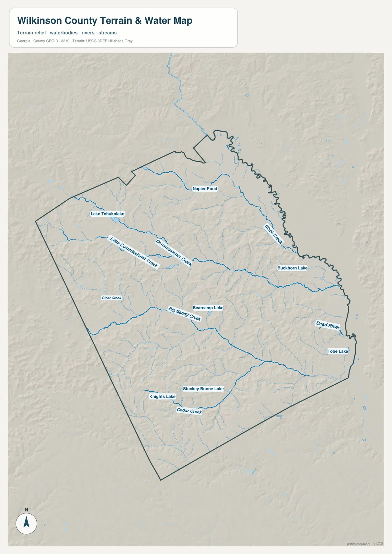
Several named lakes and ponds give the map useful landmarks. Lake Tchukolako is in the northwest, Napier Pond is farther north, Buckhorn Lake and Tobe Lake are on the eastern side, Bearcamp Lake is near the center, and Stuckey Bone Lake and Knights Lake are in the southern part of the county. Dead River is also labeled near the east. The distribution of these features reinforces the impression that water is spread throughout the rural landscape rather than concentrated around a single town.
This map should be read as a water-reference map. It is helpful for understanding where named creeks and lakes are located and how stream valleys relate to the terrain, but it does not show flood probability, water depth, legal riparian boundaries, or navigation conditions. For those questions, a dedicated official dataset is required.
Higher western ridges give way to lower eastern ground
The elevation map reports an actual county range of about 55 to 178 meters, with a mean near 100 meters. Wilkinson County is not mountainous, but it is far from completely flat. Brown and tan ridges are concentrated across much of the west and southwest, while broad green areas indicate lower terrain along the eastern and northeastern margins.
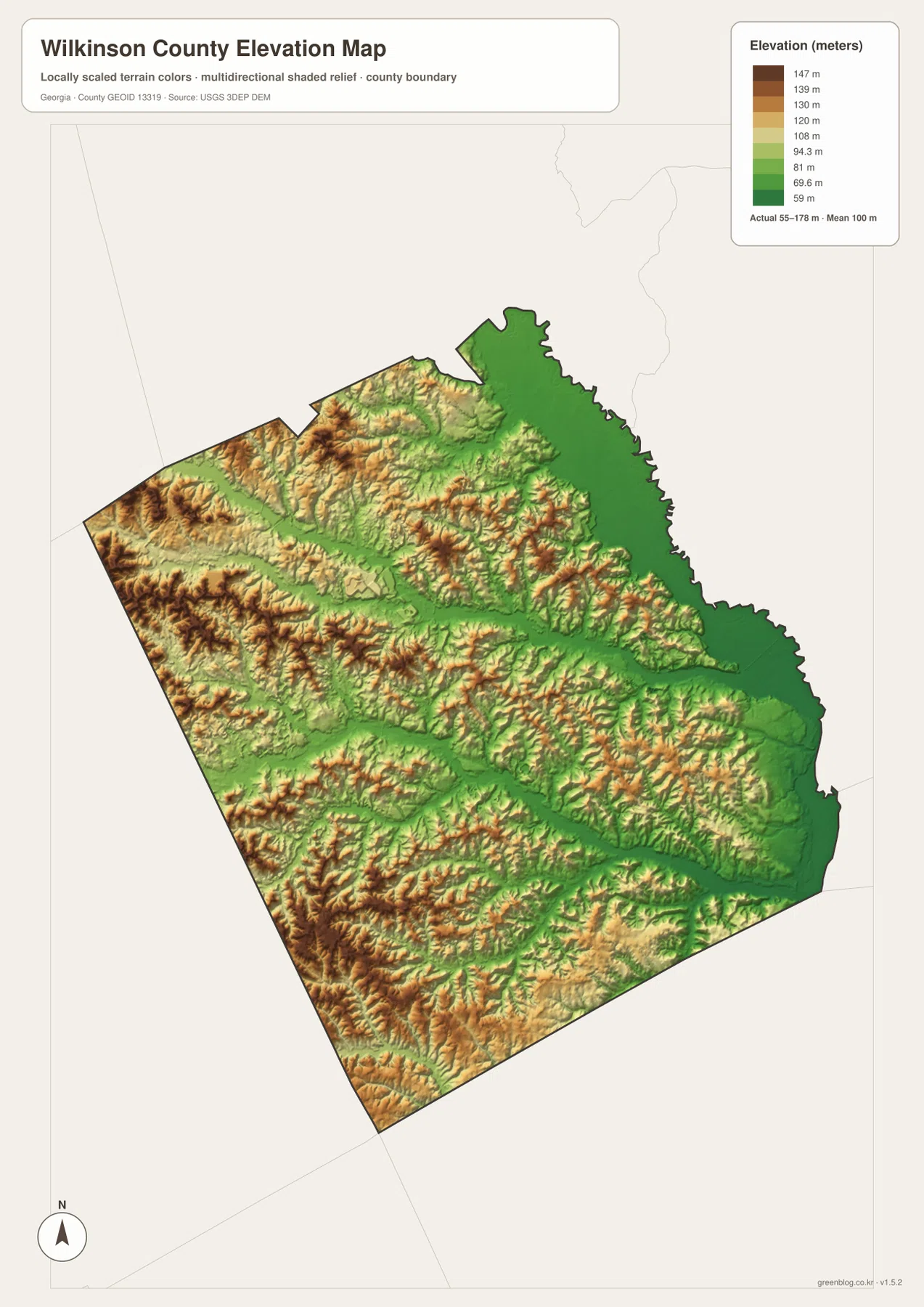
The terrain becomes more informative when compared with the water map. Long green valleys follow Commissioner Creek, Big Sandy Creek, and other channels, while higher ridges remain between the drainage lines. The Gordon-Ivey side of the county shows especially strong relief, and the eastern edge is generally lower. This pattern helps explain why the water network has so many branching tributaries: streams occupy the lower corridors between repeated low ridges.
The elevation colors are intended for regional comparison, not engineering measurement. They are useful for seeing which parts of Wilkinson County are relatively high or low, but they should not be used to determine the exact elevation, slope, or buildability of an individual property. Survey-grade work requires a more precise source.
How the kaolin setting fits the map—and what the maps do not show
The existing page material identifies kaolin mining, rail transport, forestry, agriculture, and small-town services as important parts of Wilkinson County’s background. Gordon and nearby communities are commonly discussed in connection with Georgia’s kaolin belt. That context can help a reader understand why this county is often associated with mineral production, but the four maps on this page are not mining maps. They do not locate active pits, mineral leases, processing plants, property ownership, or hauling routes.
Wilkinson County is also identified in the supplied article as having been established in 1803, with Irwinton serving as the county seat. Those facts are useful when the maps are used for history or genealogy: locating Irwinton first, then Gordon, McIntyre, Ivey, and Toomsboro, provides a geographic framework before a reader turns to older records or historical narratives.
Choosing the map that matches the question
Use the county map when the main question is where a town sits, which roads connect it, or how the county boundary is shaped. The city map is better when comparing Gordon, Ivey, McIntyre, Irwinton, and Toomsboro. The water map is the clearest choice for Commissioner Creek, Big Sandy Creek, Cedar Creek, or the named lakes, while the elevation map is most useful when a project needs to explain the contrast between rolling western ground and lower eastern valleys.
For a short report or classroom handout, one map may be enough. For a fuller geographic explanation, comparing two or more maps is more informative because the road network, settlement pattern, waterways, and elevation are closely related. The downloadable archive keeps all four versions together at a larger JPG size for printing, presentations, and personal reference.
Frequently Asked Questions
How are Gordon and Irwinton positioned within Wilkinson County?
Gordon is in the northwestern part of the county, while Irwinton is closer to the center and slightly south. McIntyre lies between their general areas. The supplied city map ranks Gordon as the largest of the five mapped communities, while Irwinton is important because it is the county seat.
Which waterways stand out on the Wilkinson County water map?
Commissioner Creek and Little Commissioner Creek are prominent across the middle of the map, with Big Sandy Creek and Cedar Creek farther south and Black Creek in the northeast. The map also labels several lakes and ponds, including Lake Tchukolako, Bearcamp Lake, Buckhorn Lake, Tobe Lake, and Stuckey Bone Lake.
Can the elevation map be used as a property survey?
No. The map is designed to show the county’s broad elevation pattern, including the roughly 55-to-178-meter range and the difference between higher western ridges and lower eastern ground. A property survey, engineering design, or exact slope calculation requires more precise site-specific data.
Sources and reference data
This article is based first on the four supplied maps and the existing Wilkinson County page material. The following sources are useful for checking county information and understanding the authoritative datasets behind boundaries, hydrography, and elevation.
- U.S. Census Bureau QuickFacts – Wilkinson County, Georgia
- New Georgia Encyclopedia – Wilkinson County
- U.S. Census Bureau TIGER/Line Shapefiles
- USGS National Hydrography
- USGS 3D Elevation Program
Map File Information
Download four high-resolution A3 JPG maps covering Wilkinson County's boundary and roads, mapped communities, water features, and elevation.
- Included Files: County map, city map, water map, elevation map
- File Type: ZIP containing four high-resolution A3 JPG files
Related Maps
Green Map creates custom-edited map images using open geographic data sources such as geoBoundaries, Natural Earth, OpenStreetMap, and government open data. These maps are edited visual materials, not raw data files, and are provided for education, documents, presentations, and graphic reference.