Osage County sits in central Missouri between several major river systems, with Linn serving as the clearest road and settlement reference. Westphalia lies to the west, Freeburg, Argyle, and Meta occupy the southern half, and Chamois sits close to the Missouri River along the northern edge. U.S. 50 crosses Linn from west to east, while Route 100 runs toward the river side of the county. The Missouri, Osage, Maries, and Gasconade rivers create a landscape of broad low valleys separated by rolling and locally steep ridges. High-resolution map files are available for download in the section below.
This page separates those features into a general county map, a city distribution map, a terrain-and-water map, and an elevation map. High-resolution JPG originals of all four can be downloaded together in one ZIP for closer inspection, A3 printing, classroom use, reports, or other large-format reference work.
Table of Contents
Linn provides the clearest road reference between U.S. 50 and Route 100
Linn sits slightly north of the county’s center and is the easiest place to begin reading the general map. U.S. 50 passes through the city from west to east, connecting the Westphalia side of the county with the Gasconade County direction. Route 100 heads north toward Chamois and the Missouri River, while several smaller routes branch away from the Linn area into the interior hills.
Westphalia provides a strong western reference near the Cole County side. Farther south, Route 63 reaches the Freeburg area, while Argyle and Meta mark the lower part of the county. Route 89 and Route 28 appear in the southeast, and Route 133 helps locate the southwest. The result is a road network that looks relatively simple around Linn but becomes more fragmented as it crosses creek valleys and higher ridges.
The northern boundary is notably different from the straighter eastern and southern edges because it follows broad bends of the Missouri River. Near Chamois, the county narrows toward the river, and the northwest boundary also curves with the floodplain. Straight-line distance can therefore be misleading, especially where roads must work around steep valleys or river crossings.
South of Linn, the map shifts from the U.S. 50 corridor into a more rural pattern around Freeburg, Argyle, and Meta. Roads often follow ridges or avoid deep creek cuts rather than forming a perfect grid. Comparing the road map with the terrain-and-water map makes those bends much easier to explain.
Six highlighted communities stretch from Chamois to Meta
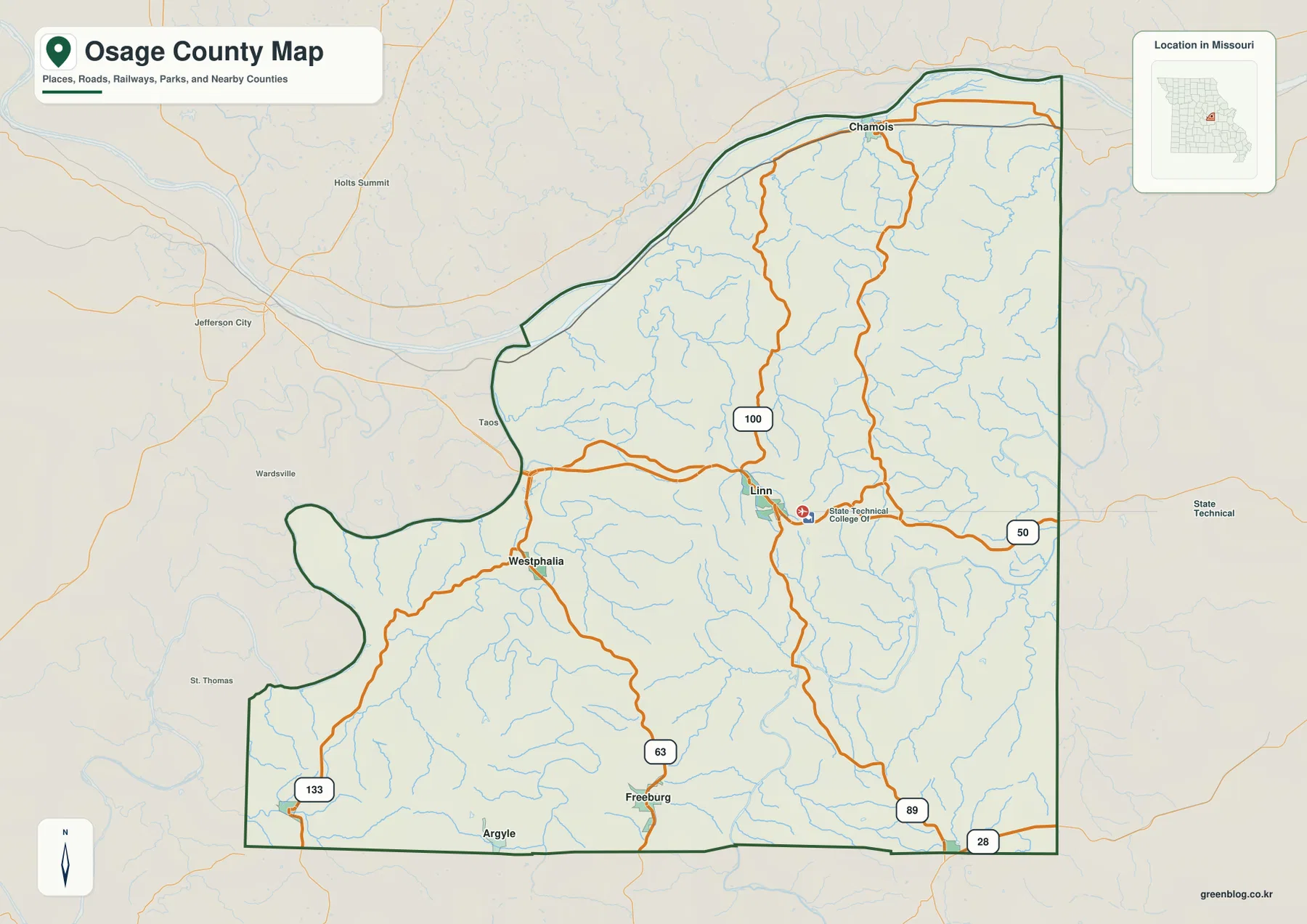
The city map highlights Linn, Westphalia, Freeburg, Chamois, Argyle, and Meta. Linn ranks first in the map’s city index and occupies a central-northern position. Westphalia lies to the west, Freeburg to the south, Chamois near the northern river edge, and Argyle and Meta farther south and southwest.
Westphalia ranks second and Freeburg third, followed by Chamois, Argyle, and Meta. The ranking is useful as a quick guide to the featured places, but their positions are more valuable for map reading. Linn and Westphalia help organize the U.S. 50 corridor, while Chamois provides the clearest northern river reference and the southern towns help frame the Maries and Osage river country.
Chamois stands apart from the other highlighted communities because it lies close to the Missouri River along the narrow northern portion of the county. Argyle and Meta, by contrast, sit near the lower county edge where creek valleys drain toward the Maries, Osage, and Gasconade systems. Remembering those positions makes the water and elevation maps much easier to interpret.
The simplified city map intentionally removes most minor roads and stream names. Large areas that appear relatively empty on this view contain dense rural road and creek networks on the other maps. It is best used as an orientation layer before moving to the more detailed county or terrain maps.
Missouri, Osage, Maries, and Gasconade valleys divide the hills
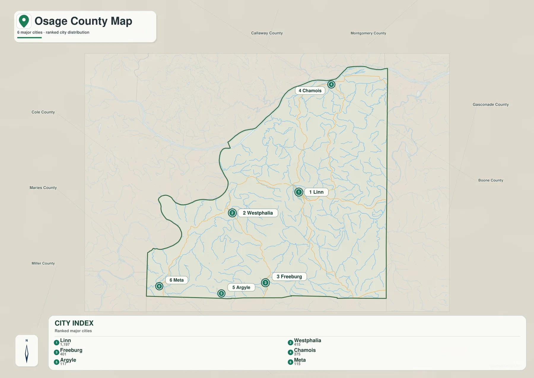
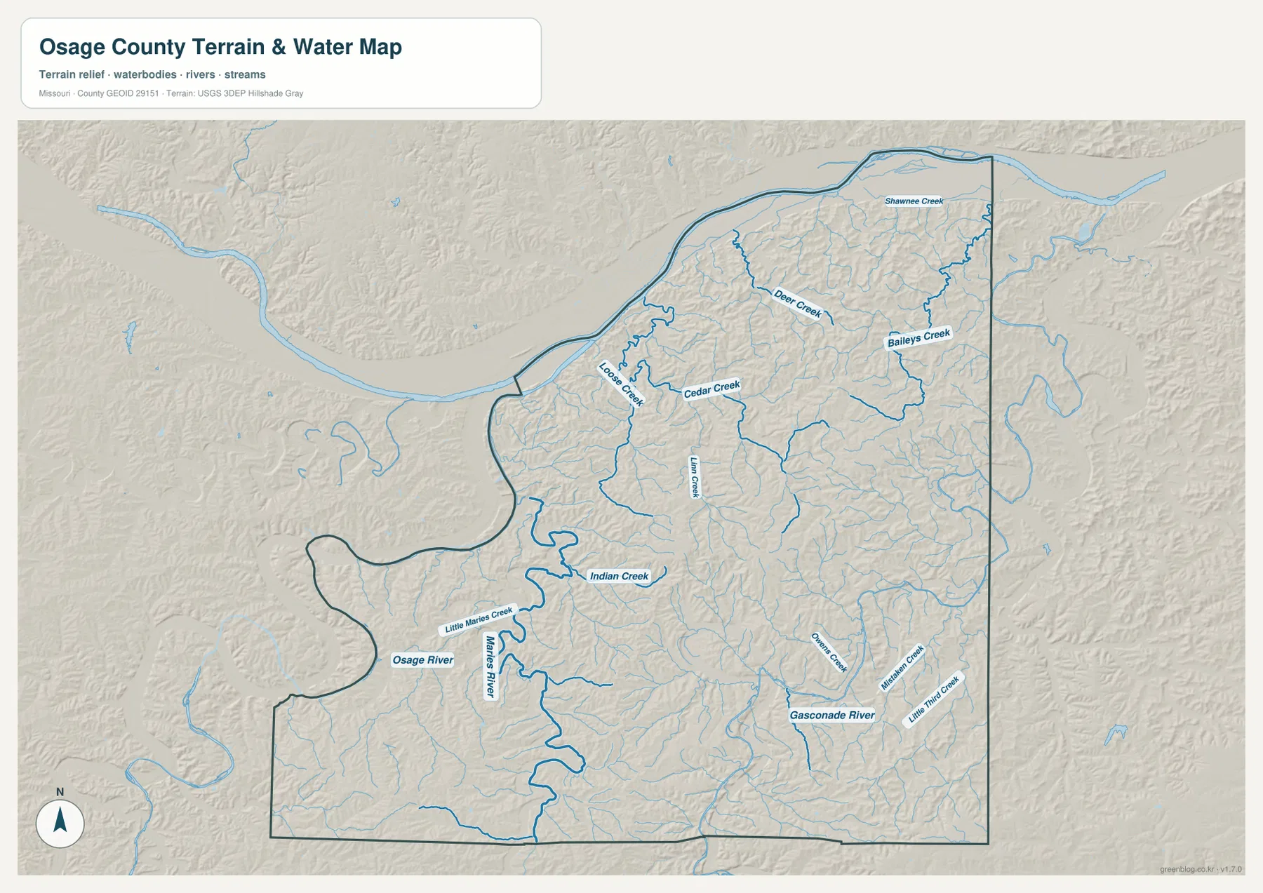
The Missouri River is the largest water feature along the northern edge, wrapping around the county in broad bends. Its valley is wider and lower than much of the interior terrain, and the contrast is especially clear near Chamois. The river boundary also explains the curved northern outline that differs so sharply from the straighter county lines elsewhere.
Inside the county, Loose Creek, Cedar Creek, Linn Creek, Deer Creek, and Baileys Creek cut separate valleys through the uplands. Loose Creek and Cedar Creek are useful references in the central-western area, while Deer Creek and Baileys Creek help organize the northeastern drainage. The smaller creeks make the terrain look much more dissected than a simple road map suggests.
The southwest is shaped by the Osage River and the Maries River, with Little Maries Creek and Indian Creek adding smaller branches. In the southeast, the Gasconade River forms another major low corridor, joined by Owens Creek, Michels Creek, and Little Third Creek. These river systems drain different parts of the county and create several distinct groups of valleys rather than one dominant central watershed.
The easiest way to read the terrain map is to identify the four major rivers first and then place the smaller creeks between them. This map is intended for geographic reference rather than flood determination, depth analysis, navigation, parcel boundaries, or legal water boundaries. Current river conditions and flood information should come from appropriate official sources.
Elevation ranges from about 154 to 286 meters
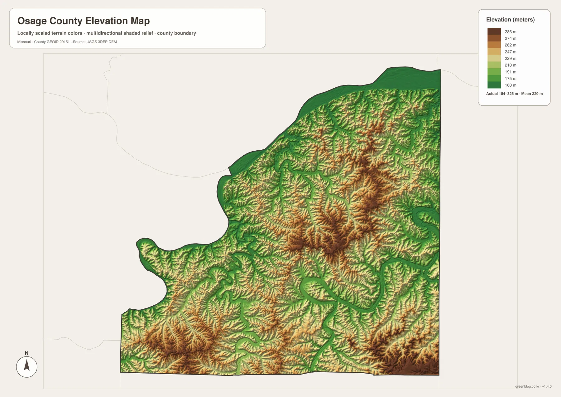
The elevation map reports an actual range of roughly 154 to 286 meters and a mean near 220 meters. The lowest greens follow the Missouri River along the north and the Osage, Maries, and Gasconade river valleys farther south. Major creeks also appear as narrow green corridors cutting into the higher interior.
Higher brown and tan terrain is concentrated across much of the central and eastern county. Ridges rise east and southeast of Linn, then drop toward Baileys Creek and the Gasconade River. The northern interior also climbs quickly away from the Missouri River, producing a clear transition from broad river bottom to rolling upland within a short distance.
High ground is also visible in the southwest and along parts of the southern edge, but the Osage and Maries river valleys break those uplands into separate blocks. The southeast contains another mix of higher ridges and deep Gasconade tributary valleys. Comparing the water and elevation maps shows how closely the green low corridors follow the named rivers and creeks.
This county-scale elevation surface is useful for comparing broad relief, not for engineering, construction, drainage design, parcel-level elevation decisions, or survey-grade measurement. Site-specific work requires more detailed official elevation data or field surveying.
Choose the map by the question you need to answer
Start with the general county map when roads and settlement locations matter most. Linn and U.S. 50 provide an immediate framework, after which Westphalia, Chamois, Freeburg, Argyle, and Meta are easy to place. The city map is faster when you only need the relative distribution of the six highlighted communities.
For rivers and creek valleys, begin with the Missouri River in the north and then compare the Osage, Maries, and Gasconade rivers. Smaller features such as Loose Creek, Cedar Creek, Deer Creek, and Baileys Creek make more sense once those larger systems are located. The elevation map then shows how those waterways occupy lower corridors between ridges.
Osage County is especially useful for comparing river bottoms with interior uplands because large waterways surround several sides of the county while high ground remains extensive in the center and east. The difference between the Missouri River edge, the Osage and Maries valleys, and the Gasconade side is much clearer when the terrain and elevation maps are viewed together.
The downloadable JPG originals contain more pixels than the WebP previews embedded on the page, making them better for enlargement, A3 printing, classroom handouts, reports, and personal reference. They remain general-purpose maps, however. Legal boundaries, property ownership, live road restrictions, flood status, and precise site elevations should always be checked against the appropriate current official source.
Frequently Asked Questions
Which roads are the easiest references around Linn?
U.S. 50 and Route 100 are the clearest starting points. U.S. 50 crosses Linn from west to east, while Route 100 runs north toward Chamois and the Missouri River. Roads south of Linn connect toward Freeburg, Argyle, and Meta.
Where is the lowest terrain shown in Osage County?
The lowest areas follow the Missouri, Osage, Maries, and Gasconade river valleys and several major tributaries. The elevation map shows an actual range of about 154 to 286 meters with a mean near 220 meters.
Which rivers are the best starting points on the terrain map?
Start with the Missouri River along the north, the Osage River in the southwest, the Maries River through the lower interior, and the Gasconade River in the southeast. Smaller creeks can then be located between those major valley systems.
Map File Information
The download ZIP contains high-resolution JPG versions of the Osage County general map, city map, terrain-and-water map, and elevation map.
- File Type: JPG
Related Maps
Sources and References
Boundary and road reference data are supported by U.S. Census Bureau TIGER/Line, water features by USGS National Hydrography, and elevation data by the USGS 3D Elevation Program. County office information centered in Linn is also available from the Missouri Association of Counties Osage County page.
Green Map creates custom-edited map images using open geographic data sources such as geoBoundaries, Natural Earth, OpenStreetMap, and government open data. These maps are edited visual materials, not raw data files, and are provided for education, documents, presentations, and graphic reference.