Volusia County Map files on this page can be previewed in the article and downloaded as high-resolution A3 JPG images in one ZIP archive. The county is easiest to understand by separating three different geographic centers: DeLand is the inland county seat, Deltona anchors the southwest near the Seminole County side, and Daytona Beach sits on the Atlantic corridor where I-4 reaches I-95. The maps also show that Volusia is more than a simple inland-versus-coast county because rivers, lakes, lagoons, and several parallel city corridors divide it into distinct parts.
The county reference map is the best overview of roads, communities, boundaries, and neighboring counties. A second map ranks six major cities—Deltona, Daytona Beach, Port Orange, Ormond Beach, DeLand, and New Smyrna Beach—so their distribution is easier to compare without every road label. The terrain-and-water map shifts attention to Lake George, the Tomoka River system, Rose Bay, Spruce Creek, Turnbull Creek, and Mosquito Lagoon. Together they show why the western river country, the southwest residential belt, and the Atlantic-lagoon side of the county should not be treated as one continuous urban strip.
Table of Contents
DeLand and Daytona Beach serve different parts of the county
DeLand lies inland, west of the county’s geographic middle, and serves as the administrative reference point. US 17/92 and SR 44 help connect it with Orange City, Lake Helen, Deltona, and the eastern side of Volusia. Daytona Beach has a very different setting. It is part of a dense Atlantic-side group that includes Ormond Beach, South Daytona, and Port Orange, and it sits near the interchange where I-4 meets I-95.
I-4 enters the county near DeBary and Deltona, runs south of DeLand, and continues east to the Daytona Beach area. That route makes the inland and coastal centers easy to connect by car, but the map does not show one unbroken city between them. Forest, wetlands, lakes, and lower-density land remain visible through the middle of the county. This separation is why DeLand and Daytona Beach should be thought of as connected centers with different roles rather than opposite ends of a single continuous downtown corridor.
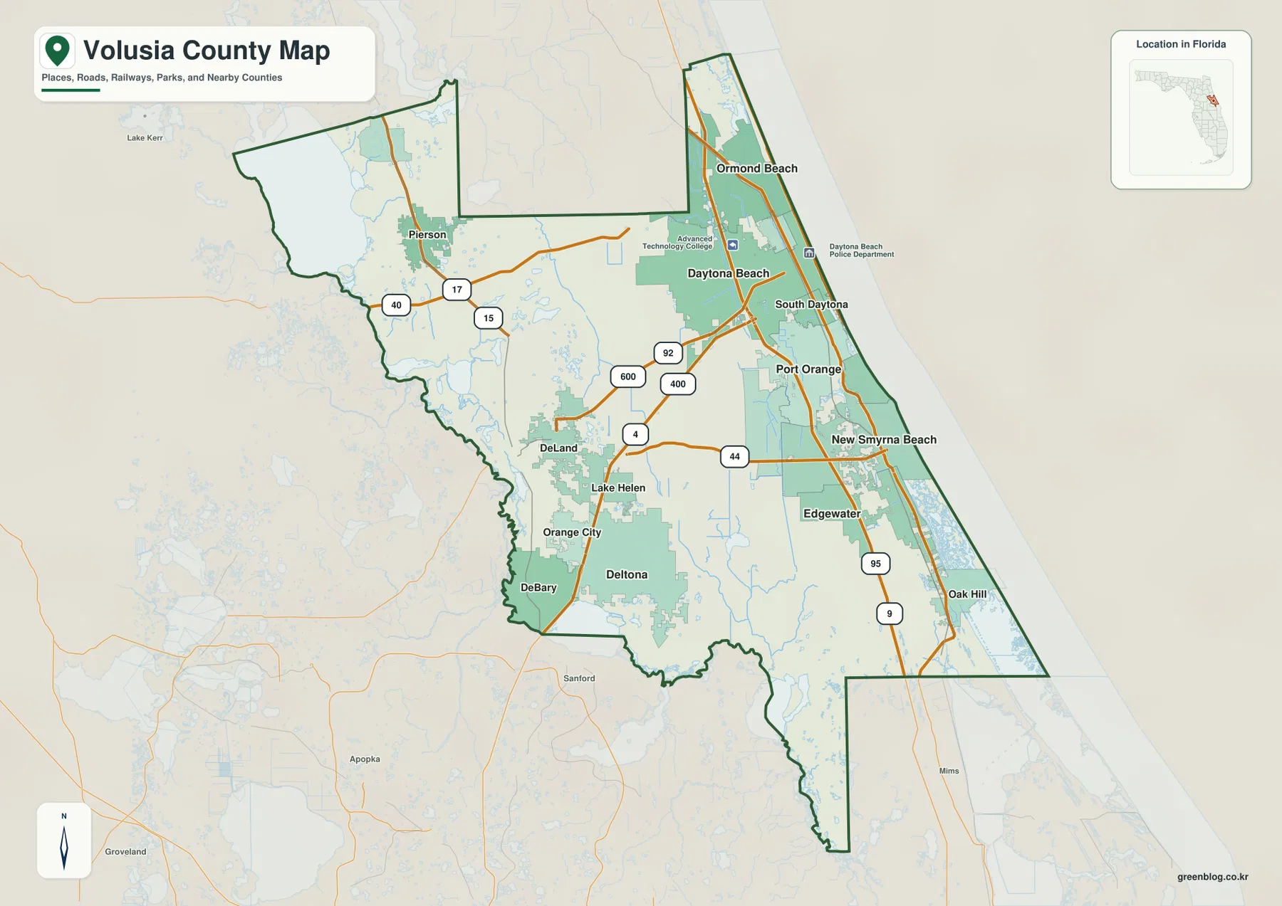
Two east-west routes also help separate the county’s coastal destinations. US 92 leads toward Daytona Beach, while SR 44 provides the more direct DeLand-to-New Smyrna Beach connection. If every eastbound trip is mentally reduced to I-4, the relationship between the county seat and New Smyrna Beach is easy to miss. Reading US 92 and SR 44 as different cross-county routes gives a much clearer picture of central Volusia.
Deltona, DeBary, and Orange City form a major southwest cluster
The city-ranking map places Deltona first among the six cities displayed. That is a useful reminder that the county’s largest city on this map is not on the Atlantic. Deltona occupies the southwest, close to DeBary and Orange City and much nearer to Seminole County than to the beach. I-4 gives the area a direct connection toward the Orlando metropolitan direction as well as east toward Daytona Beach.
DeBary sits near the western boundary and the St. Johns River/Lake Monroe side of the county. Orange City lies farther north between DeBary-Deltona and DeLand. These three places create a residential and commuter geography that is distinct from both the county-seat setting around DeLand and the tourism-heavy Atlantic communities. Looking only at Daytona Beach would therefore miss a large share of Volusia County’s populated inland area.
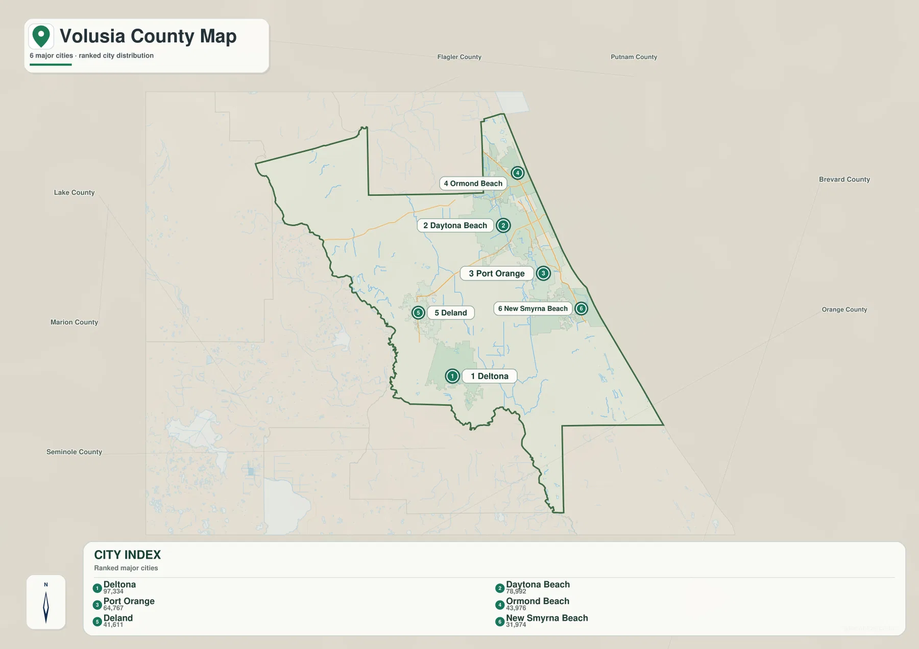
The current city index ranks Deltona first, Daytona Beach second, Port Orange third, Ormond Beach fourth, DeLand fifth, and New Smyrna Beach sixth. Those rankings summarize six major cities rather than every municipality in the county. Volusia has additional incorporated places and communities, so the value of this map is the pattern it reveals: a large inland city in the southwest, a strong north-central Atlantic cluster, and a separate southeastern group around New Smyrna Beach.
The Atlantic corridor is split between mainland, lagoon, and beach
Along the eastern side, Ormond Beach, Daytona Beach, South Daytona, and Port Orange form a closely spaced sequence. I-95 runs just west of that urban band, while US 1 serves the eastern mainland. The actual beach communities are separated from parts of the mainland by the Halifax River lagoon, so the word “coast” can hide an important detail: bridges and lagoon crossings are part of the everyday geography.
South of Port Orange, Ponce de Leon Inlet connects the Atlantic with the interior lagoon system. New Smyrna Beach lies south of the inlet and is tied to the interior by SR 44, while Edgewater continues the southeastern mainland settlement. This is not simply the southern end of Daytona Beach’s city strip. The inlet and waterway system create a break, and the road connection from DeLand also arrives on a different east-west route.
Farther south, Oak Hill is the last major labeled settlement before the county narrows toward the Brevard County side. Urban density drops sharply, and the map gives more visual space to wetlands, water, and protected land. That change is one of the strongest contrasts within Volusia County: a developed Daytona-Ormond corridor in the north-central coast, followed by a more lagoon-dominated southeastern shore.
Lake George and Mosquito Lagoon show two very different water landscapes
In the northwest, Lake George is the largest named water body on the supplied terrain-and-water map. Muddy Cove and Willow Cove are labeled around it, and the surrounding network belongs to the broader St. Johns River side of the county. This part of Volusia feels completely different from the Atlantic shore. Pierson and the US 17/SR 40 area provide the nearest settlement-and-road references for understanding that northwest lake country.
The northeastern water pattern is built around the Little Tomoka River and Tomoka River near the coast. Rose Bay appears south of Daytona Beach, and farther down the county the map labels Spruce Creek, Deep Creek, Cove Creek, and Turnbull Creek. These waterways cross low-lying land between the main road corridors and the coast, adding a network of marshy channels that is easy to overlook on a highway map.
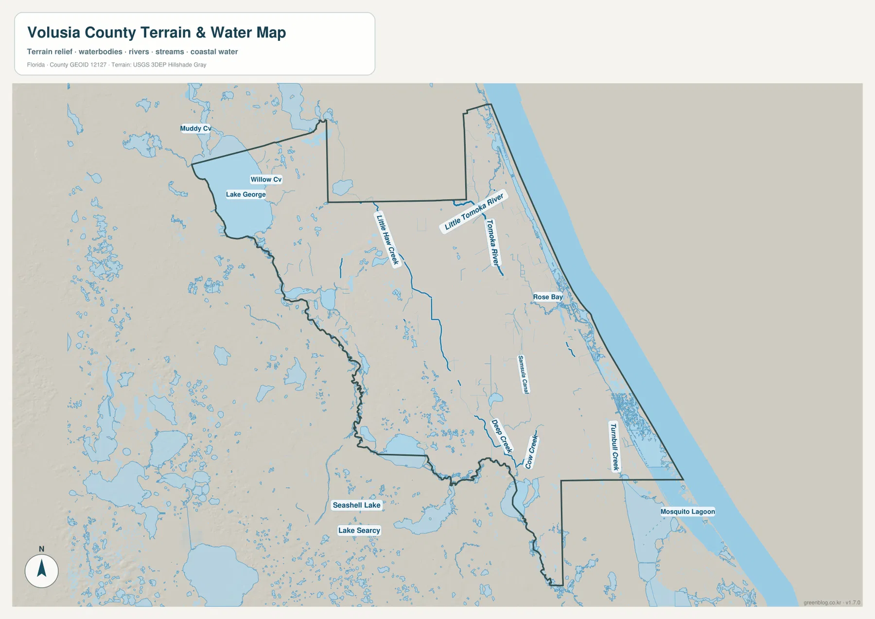
Mosquito Lagoon dominates the southeastern water view. It extends behind the Atlantic shoreline south of the New Smyrna Beach area and continues toward the county’s narrow southern reach. Here the map is more useful as a water-and-wetland reference than as a city map because settlement labels become sparse while lagoon and marsh features occupy much of the landscape. This is why the southeastern end of Volusia should not be described as just another stretch of beach towns.
The relief shading provides broad terrain context only. It is not a survey-grade elevation model, and the blue water features do not show flood zones, live water levels, navigation hazards, or property boundaries. For boating, flood planning, engineering, or parcel work, use the county map to understand location first and then consult the appropriate current official product.
The county boundary changes character from the St. Johns side to the Atlantic
Flagler County lies to the north, Lake County to the west, Seminole County to the southwest, and Brevard County to the southeast. Marion County is also close to the northwestern side shown on the reference map. The Atlantic Ocean forms the long eastern edge, while portions of the western and southern boundary follow river and lake country. That combination gives Volusia a much less regular outline than a simple coastal rectangle.
The southern boundary is especially useful for orientation. Near DeBary and Deltona, the county line bends around the St. Johns River and Lake Monroe area next to Seminole County. On the southeastern side, Volusia extends south past Oak Hill in a narrow reach before meeting Brevard County. Nearby places such as Sanford and Mims may appear close on a regional map, but they lie outside Volusia; the county outline is the best way to keep those relationships straight.
Choose the map by whether roads, cities, or water matter most
Use the county reference map for DeLand, Deltona, Daytona Beach, neighboring counties, and the major road network including I-4, I-95, US 17/92, US 92, and SR 44. The ranked city map is cleaner when your question is where the six displayed major cities sit relative to one another. The terrain-and-water map is the strongest choice for Lake George, the Tomoka River system, Rose Bay, Spruce Creek, Turnbull Creek, and Mosquito Lagoon.
For a classroom or presentation sequence, begin with the county map to establish the inland and Atlantic centers, use the city map to compare the southwest and coastal population pattern, then switch to the water map to explain why the northwest lake country and southeastern lagoon country look so different. The same approach works for general trip orientation, but current driving directions, bridge conditions, beach access, and closures should be checked separately.
Frequently Asked Questions
Is Daytona Beach the county seat?
No. DeLand is the county seat and the main administrative reference in the interior. Daytona Beach is a larger Atlantic-side transportation and service center, but it does not hold the county-seat role.
Is Deltona one of the beach cities?
No. Deltona is inland in southwestern Volusia County near DeBary and Orange City. It connects toward the Atlantic side by I-4, but its geography is much closer to the Seminole County/Orlando direction than to the oceanfront communities.
Do DeLand-to-Daytona Beach and DeLand-to-New Smyrna Beach use the same east-west corridor?
Not exactly. US 92 is the clearest east-west reference toward Daytona Beach, while SR 44 provides the more direct route toward New Smyrna Beach. Treating them as separate corridors makes the county map much easier to read.
Which map is best for Mosquito Lagoon?
The terrain-and-water map is the better choice because it shows Mosquito Lagoon together with Turnbull Creek and other southeastern waterways. It is a location reference, however, not a nautical chart, flood map, or live water-condition product.
Map File Information
Download the Volusia County reference map, city map, and terrain-and-water map as high-resolution A3 JPG files.
- Included Files: County map JPG, city map JPG, terrain-and-water map JPG
- File Type: Three JPG files in one ZIP archive
Related Maps
- A Sumter County Florida Map
- Arcadia Roads and Peace River | DeSoto County Florida Map
- Baker County Florida Map
Sources and References
These public sources provide additional context for Volusia County communities, transportation, coastal management, and mapped water features.
- Volusia County official history
- Volusia County cities and communities
- U.S. Census Bureau – Volusia County QuickFacts
- Florida Department of Transportation – Volusia County transportation profile
- Florida DEP – Ponce de Leon Inlet Management Plan
- USGS National Hydrography
Green Map creates custom-edited map images using open geographic data sources such as geoBoundaries, Natural Earth, OpenStreetMap, and government open data. These maps are edited visual materials, not raw data files, and are provided for education, documents, presentations, and graphic reference.