Fairbanks North Star Borough stretches far beyond the city of Fairbanks into a large section of Alaska’s Interior. On the supplied county map, the densest cluster of named places sits on the western side around Fairbanks, Ester, Goldstream, Chena Ridge, Steele Creek, Badger, and North Pole. Farther south, Eielson AFB, Salcha, and Harding-Birch Lakes form another sequence of useful reference points, while the broad eastern half of the borough contains far fewer settlement labels and many more streams. This page explains those visible relationships in plain language, and the same map subjects are available as high-resolution JPG files in the ZIP download box below.
A good way to orient yourself is to start at Fairbanks and then look outward. North Pole lies southeast of the city, with Badger spread through the area between and around them. Goldstream and Steele Creek sit north of the core, Pleasant Valley is farther east, and the route toward Eielson AFB and Salcha continues south. The terrain-and-water map then adds the other half of the story: the Chena River system cuts through the borough, the Tanana River creates a broad southern reference line, and the eastern interior is broken by numerous tributaries and ridges. Reading the settlement map and water map together makes the borough much easier to understand than treating Fairbanks as if it represented the entire area.
Table of Contents
The Fairbanks cluster occupies only a small part of a very large borough
The county map immediately shows how strongly named places are concentrated in the west. Fairbanks is the clearest anchor. Ester and Chena Ridge lie to its west, Goldstream is northwest, and Steele Creek sits to the northeast. Badger and North Pole extend the settled pattern toward the southeast, while Pleasant Valley appears farther east as a separate reference point. This grouping is visually compact compared with the enormous eastern section of the borough, where the boundary continues for a long distance with only a few named facilities or places but a dense network of blue waterways.
Road shields numbered 2, 3, and 6 are visible on the map, and the highlighted roads help connect the place names to one another. A main route runs from the Fairbanks area toward North Pole, Eielson AFB, Salcha, and Harding-Birch Lakes, while other marked roads extend north and west from the urban core. These lines are useful for orientation, but the map is not a live transportation product. It does not show current construction, winter closures, travel times, surface conditions, or traffic. Use the road network here to understand direction and relative location, then check current transportation sources when an actual trip depends on up-to-date conditions.
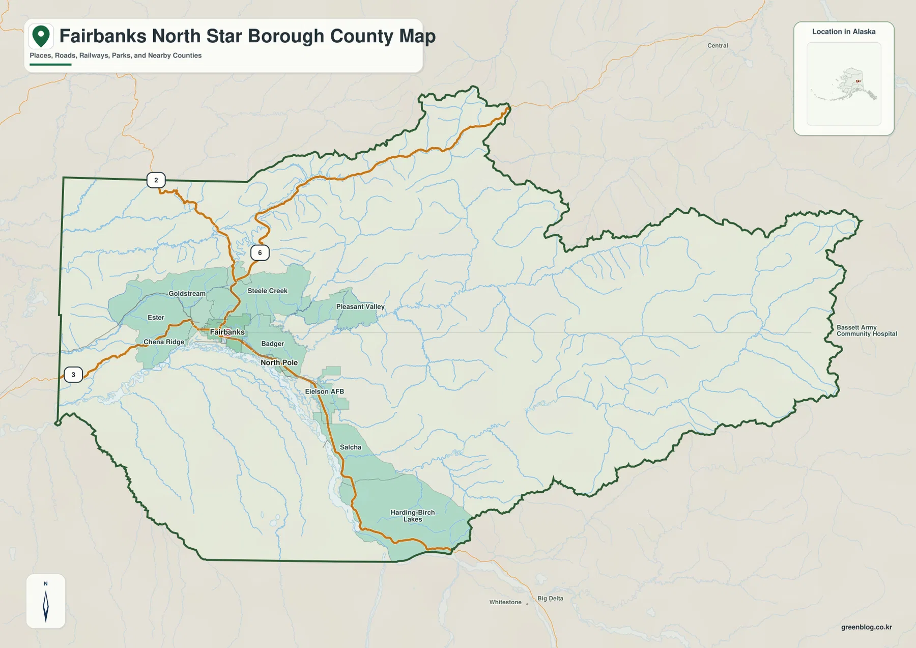
The borough outline also helps explain scale. The western edge around the Fairbanks cluster is comparatively compact, but the boundary reaches far north and east before turning back across the southern interior. Much of that eastern space contains branching streams rather than settlement labels. A Bassett Army Community Hospital label near the far eastern side provides another recognizable reference point and reinforces how far the borough extends beyond the Fairbanks–North Pole core. For a quick view of settlements, roads, water, and the outer boundary on one page, this is the most useful of the supplied maps.
The city index reduces the picture to Fairbanks and North Pole
The city-index map intentionally simplifies the settlement picture. It ranks Fairbanks first and North Pole second, placing large numbered markers on the two locations. The printed CITY INDEX also shows the values 32,083 for Fairbanks and 2,370 for North Pole. Those numbers are part of the supplied map artwork, so they are reported here only as map content rather than presented as independently verified current population estimates. Anyone who needs the latest population figures should consult current U.S. Census Bureau data.
The main value of this map is spatial, not statistical. Fairbanks and North Pole are close enough to appear in the same western cluster, but North Pole is clearly southeast of Fairbanks. Badger, Steele Creek, Ester, Pleasant Valley, and other labels from the county map do not appear in this ranked city index. That difference does not mean those places disappeared from the geography; it simply reflects the index’s narrower selection. Use the county map when you want a broad set of place names and the city index when you want the two ranked city markers with minimal visual clutter.
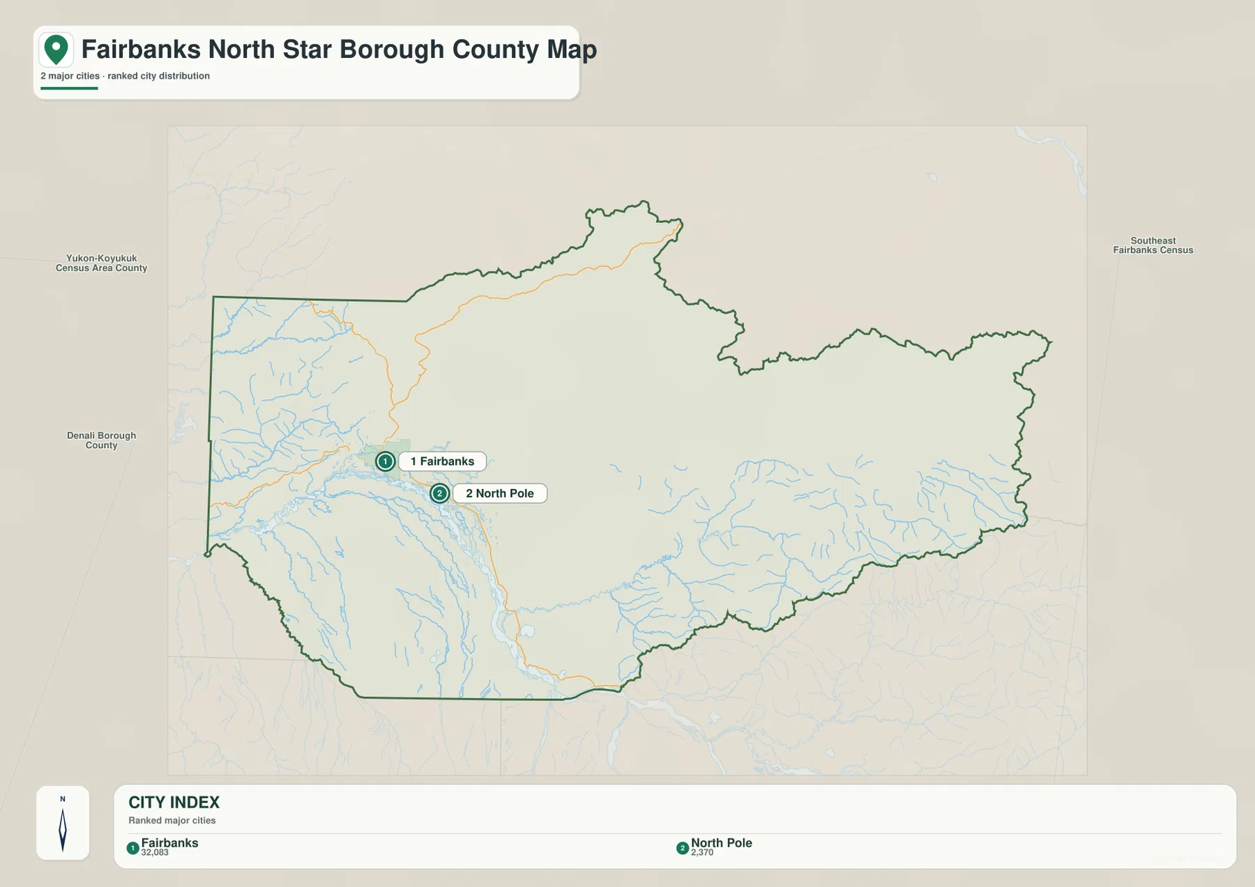
Labels outside the borough include Yukon-Koyukuk Census Area, Denali Borough, and Southeast Fairbanks Census Area. They help place the borough within Alaska’s Interior at a larger scale. The background should not be treated as a parcel survey or a substitute for legal boundary records, however. If an exact administrative line matters, the Census Bureau’s TIGER/Line boundary data is the better source to consult.
The Chena system branches across the interior before the Tanana lowland
The terrain-and-water map reveals a network that is easy to miss on the settlement map. Chena River is labeled near the Fairbanks side of the borough, while Little Chena River, Middle Fork Chena River, and South Fork Chena River occupy different parts of the interior. Little Chena River appears in the north-central area. Middle Fork Chena River stretches across the eastern middle of the borough, and South Fork Chena River runs farther south. The repeated Chena name can make the water system look confusing at first, but the map separates the branches clearly enough to use each one as its own location marker.
Northwest of the Fairbanks area, Chatanika River forms another long labeled waterway. Farther east, Salcha River crosses a rugged section of the borough and trends toward the southern side. The largest southern reference is Tanana River, which occupies a broad, braided-looking corridor below the Fairbanks–North Pole area. When the settlement map and water map are compared, Fairbanks, North Pole, Eielson AFB, and Salcha all make more sense as places arranged near this large southern river system rather than as isolated dots on a blank background.
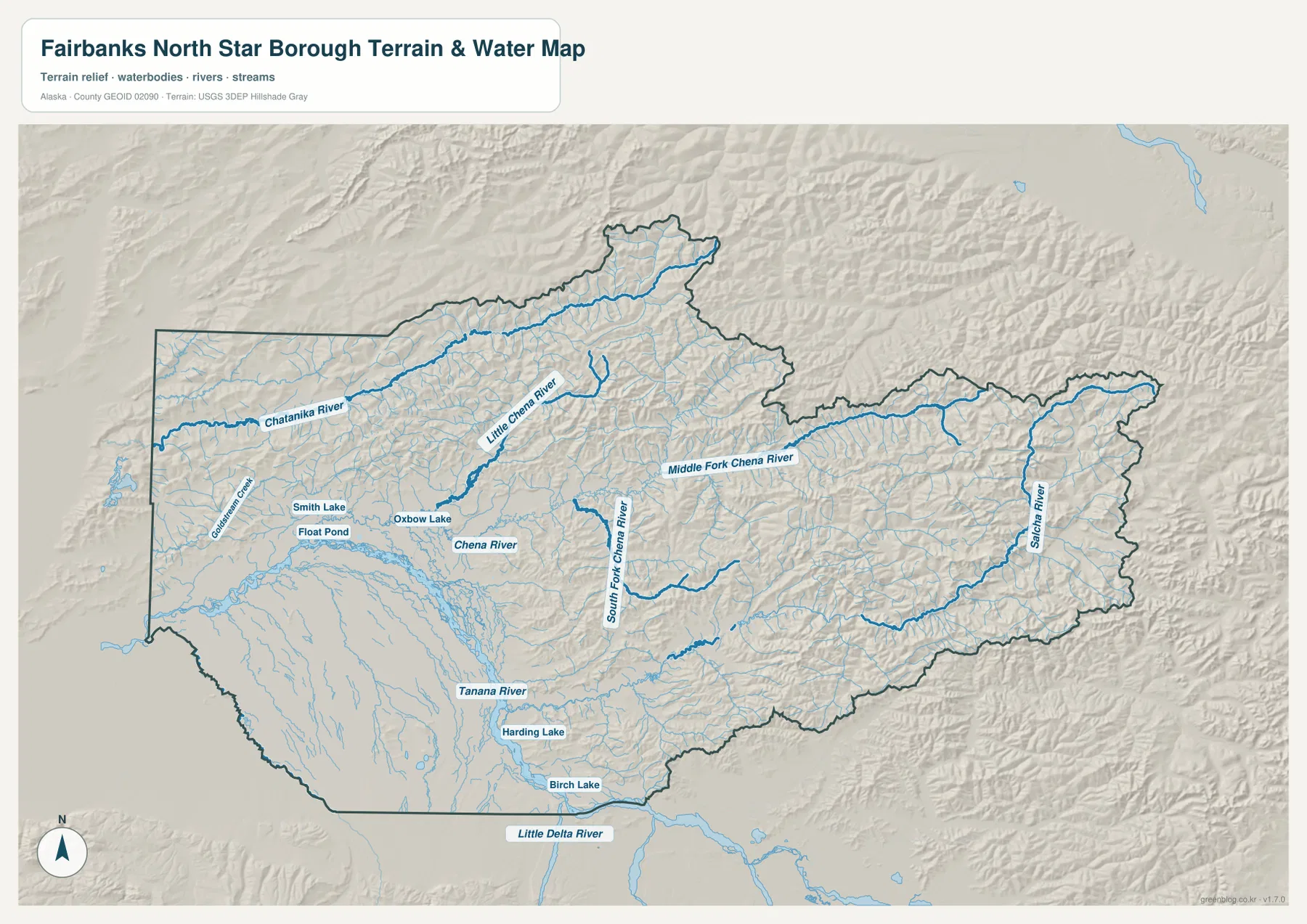
Smaller water features add useful detail around the populated western and southern areas. Goldstream Creek is labeled west of the city cluster. Smith Lake, Float Pond, and Oxbow Lake appear near Fairbanks, while Harding Lake and Birch Lake sit much farther south. Little Delta River is labeled beyond the borough’s southern edge as an additional regional reference. These names are especially helpful when a place such as Harding-Birch Lakes is easier to locate by nearby water than by settlement labels alone.
This map should be read as a terrain and hydrography reference, not as a flood map, navigation chart, ice-safety guide, or water-rights document. It shows where named rivers, streams, and lakes sit in relation to the borough and shaded terrain. Detailed channel geometry, official hydrography, or current water conditions should be checked through dedicated sources such as USGS National Hydrography.
Rugged eastern terrain contrasts with the broader Tanana River corridor
The shaded terrain is another strong feature of the supplied water map. Much of the eastern and northeastern borough has tightly spaced ridges and valleys, especially around the Middle Fork Chena River and Salcha River. The southern corridor along the Tanana River looks broader and smoother by comparison. This contrast helps explain why the map feels densely textured in the interior even though relatively few settlement names appear there. The terrain itself, rather than a concentration of towns, becomes the dominant visual information.
The same contrast is visible when you move east from Fairbanks. Pleasant Valley is one of the last prominent settlement labels on the basic map before the interior becomes dominated by streams and ridges. South of the city cluster, the Tanana River corridor is more open, and several named places follow that general direction toward Eielson AFB, Salcha, and Harding-Birch Lakes. The borough therefore combines a relatively compact western population center, a broad southern river corridor, and a much larger interior where terrain and waterways are the main map features.
The hillshade is generalized visual relief. It is useful for seeing where the land looks more mountainous or dissected, but it is not survey-grade elevation information. The map does not provide precise summit heights, engineering slopes, or construction-grade measurements. For exact elevation values or terrain analysis, use a dedicated dataset such as the USGS 3D Elevation Program.
A west-to-south reading order makes the place names easier to remember
If the borough is unfamiliar, a simple reading order can keep the many labels from becoming overwhelming. Begin at Fairbanks, then look west to Ester and Chena Ridge and northwest to Goldstream. Return to Fairbanks and move east through Steele Creek and Pleasant Valley. Next, follow the settlement pattern southeast through Badger and North Pole, then continue south to Eielson AFB, Salcha, and Harding-Birch Lakes. Once that sequence is familiar, switch to the water map and add Chena River, Tanana River, and the eastern Chena and Salcha branches.
The large eastern interior is easier to understand with rivers than with towns. Middle Fork Chena River and Salcha River are strong anchors there, while Chatanika River helps organize the northwestern side. Tanana River ties the southern portion of the borough together visually. This approach keeps the map grounded in actual labeled features: named places explain the developed western side, and named waterways explain much of the sparsely labeled interior.
Choose the map that matches the question you are trying to answer
For settlements, roads, and the borough boundary, the county map is the clearest starting point because it places Fairbanks, North Pole, Badger, Ester, Goldstream, Pleasant Valley, Eielson AFB, and Salcha on one page. A clean two-marker comparison of Fairbanks and North Pole comes from the city index. When the Chena River branches, Chatanika River, Salcha River, Tanana River, Harding Lake, Birch Lake, and relief matter more than settlement labels, the terrain-and-water map is the better choice. Each map removes some detail and emphasizes something else, so matching the map to the question makes the page faster to use.
- Settlements, roads, and boundary: start with the county map.
- Fairbanks versus North Pole: use the ranked city index.
- Rivers, lakes, and terrain: use the terrain-and-water map.
- Legal or current decisions: verify boundary, road, flood, hydrography, and elevation details with the appropriate current official source.
For a classroom presentation, one useful sequence is to show the county map first, then use the city index to simplify the western population core, and finish with the water map to explain why the rest of the borough is dominated by rivers and rugged terrain. If you need a larger image than the on-page WebP, the ZIP below contains high-resolution JPG versions of the same three map subjects. They are suitable for printing, offline reference, and presentation use, but not as substitutes for survey, emergency, or live transportation data.
Frequently Asked Questions
Why are Badger and Steele Creek on the county map but not in the city index?
The county map includes a broader set of settlement and place labels, while the supplied city index ranks only Fairbanks and North Pole. Badger, Steele Creek, Ester, Pleasant Valley, and other labels therefore remain useful geographic references even though they are not part of the two-city ranking. The difference comes from the map purpose, not from a missing label in the county map.
Which map is best for finding both Chena River and Tanana River?
The terrain-and-water map is the best choice. It labels Chena River along with Little Chena River, Middle Fork Chena River, and South Fork Chena River, and it also shows the broad Tanana River corridor to the south. Chatanika River, Salcha River, Harding Lake, and Birch Lake are visible on the same map, making it the clearest option for comparing the borough’s major water features.
What files are included in the download ZIP?
The ZIP contains three high-resolution JPG files matching the map subjects used on the page: the county map, the city index map, and the terrain-and-water map. It does not include a live traffic map, flood-risk map, parcel survey, or engineering elevation product. The files are intended for geographic reference, print, classroom, and presentation use.
Map File Information
Download the Fairbanks North Star Borough maps as high-resolution JPG files. The ZIP contains larger versions of the three map subjects shown on this page for printing, classroom use, presentations, and offline geographic reference.
- Included Files: 3 high-resolution JPG images
- File Type: JPG files in one ZIP archive
Related Maps
Sources and References
This article is based primarily on the supplied Fairbanks North Star Borough maps, including their labeled settlements, road markers, city index, rivers, lakes, boundary, and terrain shading. The following official sources are useful for borough information and more detailed boundary, hydrography, and elevation data.
- FNSB History, Facts & Figures
- U.S. Census Bureau TIGER/Line Shapefiles
- USGS National Hydrography
- USGS 3D Elevation Program
Green Map creates custom-edited map images using open geographic data sources such as geoBoundaries, Natural Earth, OpenStreetMap, and government open data. These maps are edited visual materials, not raw data files, and are provided for education, documents, presentations, and graphic reference.