You can download the four high-resolution JPG maps of Hamlin County on this page in one ZIP file, while the WebP versions in the article are sized for quick viewing. Lake Norden is a useful place to start: it sits near the south-central part of the county, with Estelline farther east near the southeastern edge, Hayti to the north, and Castlewood in the northeast. From those communities the maps expand into a broader picture of numbered roads, the Big Sioux River, a chain of lakes along the south, and a relief surface that ranges from about 497 to 596 meters.
Hamlin County looks fairly simple in outline, but the maps show several different landscapes inside that rectangle. The east is cut by the Big Sioux River and many short tributaries, the south includes Lake Poinsett and other sizable lakes, and the western half contains more rolling higher ground. Lake Norden and Hayti sit between those zones, which makes them helpful reference points when moving from the road map to the water and elevation layers. Reading the maps together is more informative than treating each one as a separate inventory.
Table of Contents
Lake Norden and Hayti anchor the middle of the county
The general county map makes Lake Norden and Hayti the easiest interior landmarks to find. Lake Norden lies close to the south-central edge, where the east-west road through Bryant and Estelline meets the north-south route labeled 81. Hayti is farther north and slightly west of that line, near route 21. Hamlin County’s official government site also places the county government offices and courthouse in Hayti, so the town works as both a geographic and administrative reference point.
The rest of the labeled communities spread outward rather than clustering around one center. Bryant is near the southwest, Hazel is in the northwest, Castlewood is in the northeast, and Estelline is near the southeast. The map also shows route labels 21, 22, 28, 29, and 81. Those numbered lines are useful for orientation, but this image is not a turn-by-turn road map; its value is in showing how the towns, roads, lakes, and county boundary fit together at county scale.
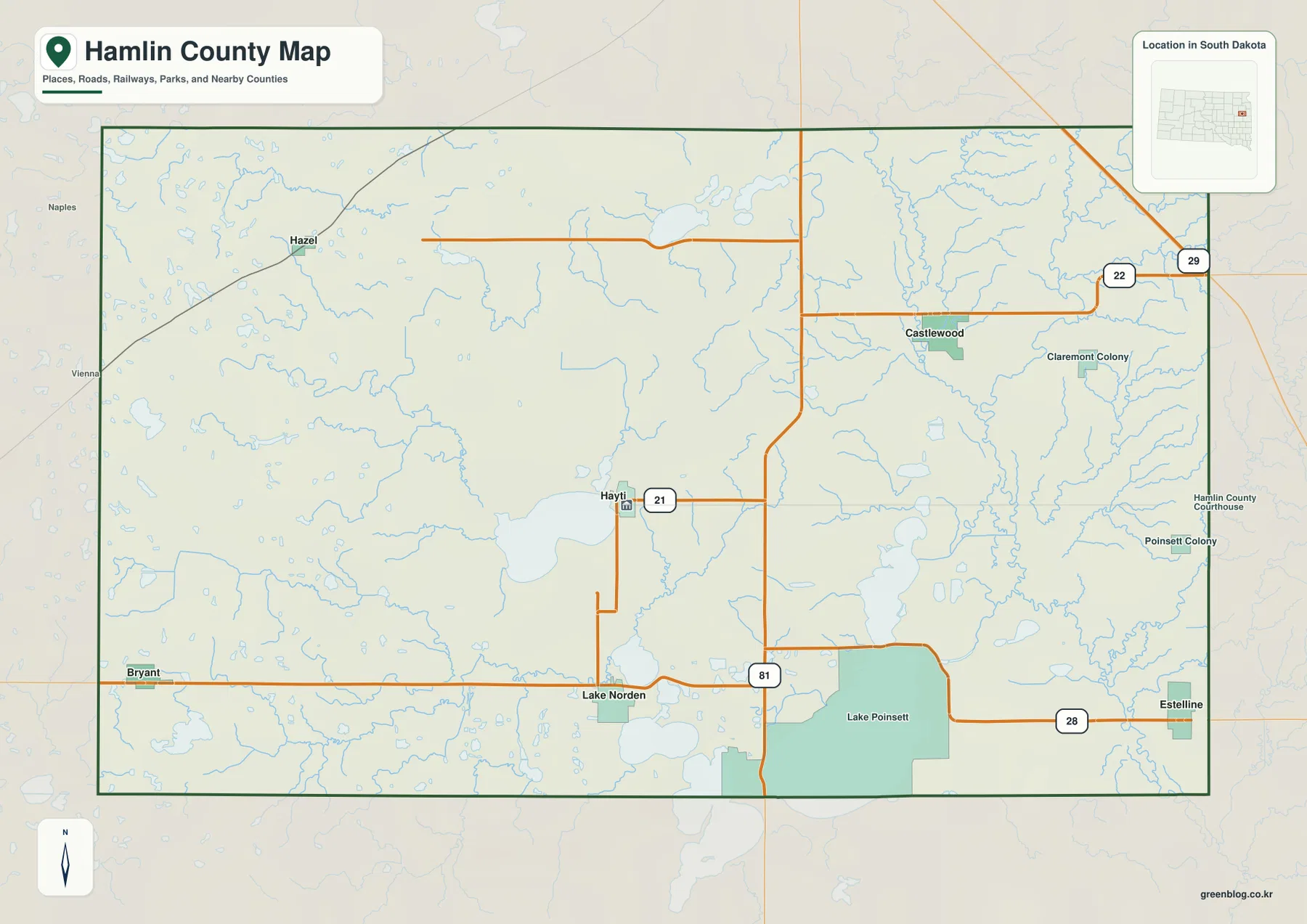
The southern edge is especially distinctive because several lakes interrupt what would otherwise be a simple road-and-town pattern. Lake Poinsett occupies a large area near the southeast, and other water bodies appear around Lake Norden and farther west. That water explains why route 28 and the south-central settlements are easier to understand when the road layer is compared with the water map rather than viewed alone.
Six highlighted communities stretch from Hazel to Estelline
The ranked community map removes most secondary detail and highlights six places: Lake Norden, Estelline, Castlewood, Bryant, Hayti, and Hazel. The city index places Lake Norden first, Estelline second, and Castlewood third, followed by Bryant, Hayti, and Hazel. Those numbers are simply the ranking shown on the supplied graphic; this article does not treat them as a substitute for a current population table.
Their positions create a broad spread across Hamlin County. Lake Norden is south-central, Estelline is at the southeast side, Castlewood is in the northeast, Bryant is southwest, Hazel is northwest, and Hayti is near the middle. This makes the community layer useful for memorizing relative position before switching to a more detailed map. If you know that Castlewood is northeast of Hayti and that Estelline is much farther south, the road and water layers become easier to read.
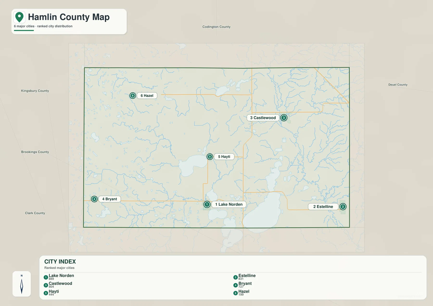
No connector line or distance value appears on this city map. It should therefore be used for relative location, not for driving mileage, straight-line distance, or travel time. A current routing service is the right source for those questions. The strength of this layer is its simplicity: it gives a clean mental picture of where the six highlighted places sit inside the county before more detailed features are added.
Big Sioux River and the southern lakes organize the water map
The terrain-and-water map is dominated by the Big Sioux River along the eastern side of Hamlin County. The river forms a long north-south low corridor and receives a dense set of smaller tributaries. Farther south, Lake Poinsett is the largest named lake on the map, with Lake Albert, Lake St John, and Lake Norden extending westward from the same general lake-rich zone. Lake Marsh sits farther into the interior, while Clear Lake and Five Ponds appear in the north-central part of the county.
Dolph Creek is labeled across the southwest and approaches the Lake Norden area from the west. Hidewood Creek is labeled near the southeast, and many shorter unnamed branches feed the larger eastern drainage. These blue lines help explain why the eastern half of the county has a more dissected surface than the broad western uplands. The water layer also makes the southern communities easier to place: Lake Norden is associated with the lake-and-creek zone, while Estelline sits closer to Lake Poinsett and the lower eastern drainage.
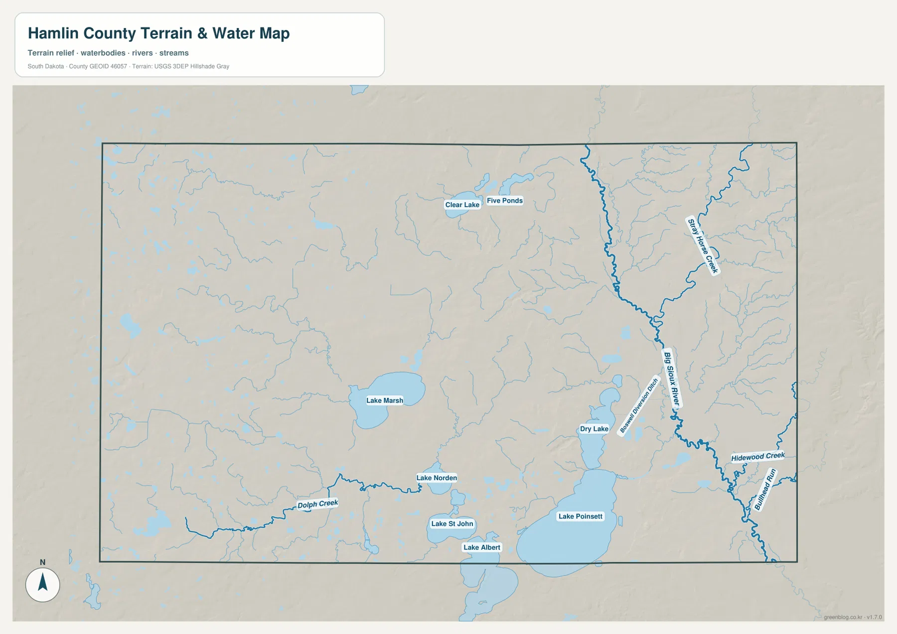
Lake Poinsett is also a useful county-specific reference beyond the map itself. South Dakota Game, Fish and Parks operates the Lake Poinsett Recreation Area, and its fisheries material identifies the lake with both Hamlin and Brookings counties. That matches the supplied county map, where the large lake lies along the southern edge rather than entirely in the interior. For orientation, it is better to think of Lake Poinsett as a major southern boundary landmark than as a lake centered within Hamlin County.
This water map is a geographic reference, not a flood-hazard, parcel, legal-boundary, depth, or navigation product. It shows the relative placement of rivers, creeks, lakes, and terrain visible in the supplied image. Questions about flood probability, property ownership, channel conditions, or boating restrictions require the appropriate current agency source.
Relief falls into the Big Sioux corridor and Lake Poinsett basin
The elevation map gives an actual county range of about 497 to 596 meters and a mean near 530 meters. Much of the west and northwest appears in yellow and brown tones, indicating higher rolling ground. A broad green corridor cuts through the eastern interior along the Big Sioux River, and the Lake Poinsett area in the south is also among the lower parts of the county. The contrast is strong enough to see why the river and lake system occupies a different physical setting from the western communities.
The pattern is not a simple west-to-east slope. Higher ridges also appear near parts of the far eastern edge, while the Big Sioux River remains low between those ridges and the interior uplands. In other words, the most important feature is a low north-south river corridor bordered by higher ground, not a single uniform descent across the county. Comparing the elevation layer with the water map makes that structure especially clear.
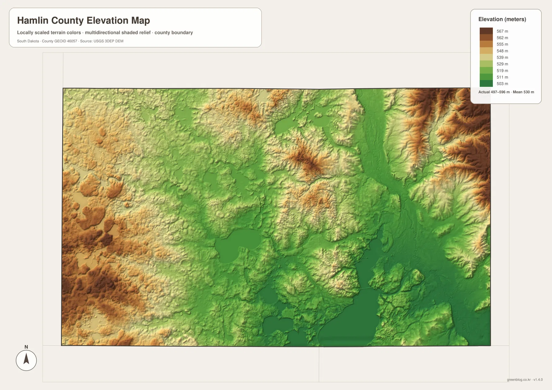
Lake Norden and Hayti lie in more moderate terrain between the highest western patches and the deepest eastern low corridor. Castlewood is closer to the Big Sioux drainage, where green lower ground becomes more extensive. Estelline and Lake Poinsett also sit near low terrain and water, while Bryant and Hazel are associated with more of the higher western colors. These are broad county-scale relationships, not precise elevation statements for individual streets or buildings.
The elevation surface is intended for general geographic comparison. It is useful for seeing which areas are broadly higher or lower, where major valleys cut through the county, and how lakes fit into the low terrain. It should not be used as survey-grade or engineering-grade measurement for construction, drainage design, or a specific parcel. For those purposes, use the original agency elevation data and appropriate field measurements.
Choose the map by the question you want to answer
The general map is the best first choice when you need town names, the county outline, and numbered roads in one view. The ranked community map is better when the goal is simply to remember where Lake Norden, Estelline, Castlewood, Bryant, Hayti, and Hazel sit relative to one another. The terrain-and-water map is the clearest layer for the Big Sioux River, Lake Poinsett, Lake Marsh, and the smaller lakes and creeks. The elevation map is the right choice for comparing the high western ground with the low river and lake corridors.
A place-by-place approach works well. For Estelline, begin with the general map to locate the southeast community and route 28, then move to the water layer to see Lake Poinsett and the eastern drainage, and finish with the elevation map to see how low the surrounding terrain is. For Hazel, start with the community layer to place it in the northwest and then compare the elevation colors that show more high ground in the west. This method turns the four maps into a connected county description rather than four repeated summaries.
For printing or presentation work, use the original JPG files in the ZIP below rather than enlarging the in-article WebP previews. Each JPG is 3638 × 2572 pixels, and the archive contains one general county map, one ranked community map, one terrain-and-water map, and one elevation map. The WebP images are convenient for quick browsing; the JPG files are the better choice when you need a larger canvas or an A3 print.
Frequently Asked Questions
Where are Lake Norden and Estelline in Hamlin County?
Lake Norden is near the south-central part of the county, while Estelline is much farther east near the southeastern edge. Both are easy to find along the southern road corridor shown on the general map, but Estelline is closer to Lake Poinsett and the lower eastern drainage. The city map has no distance connector, so current road mileage and travel time should be checked separately.
Which map is best for the Big Sioux River and Lake Poinsett?
Use the terrain-and-water map first. It shows the Big Sioux River running through the eastern side of the county and Lake Poinsett as the large water body near the southern edge. Pairing it with the elevation map adds useful context because both the river corridor and the Lake Poinsett area lie in lower green terrain.
Does the 497–596 meter elevation range give survey-grade heights?
No. The legend summarizes the broad county relief, with an actual range of roughly 497–596 meters and a mean near 530 meters, but the image is a generalized county-scale surface. Use it to compare high and low areas, not to determine the precise elevation of a road, building, construction site, or parcel.
Map File Information
The ZIP contains the original JPG versions of the Hamlin County general map, ranked community map, terrain-and-water map, and elevation map. Use these larger files when the article previews are not enough.
- Printable Size: 3638 × 2572 px each
Related Maps
Sources and references
- Official Hamlin County, South Dakota Government Website – county government, courthouse, and community information for Hamlin County.
- U.S. Census Bureau TIGER/Line Shapefiles – official boundary, road, and geographic reference data.
- USGS National Hydrography – official U.S. Geological Survey hydrography information for rivers, streams, and water bodies.
- USGS 3D Elevation Program – official elevation data and 3DEP information.
- South Dakota Game, Fish and Parks – Lake Poinsett Recreation Area – official park and visitor information for Lake Poinsett.
Green Map creates custom-edited map images using open geographic data sources such as geoBoundaries, Natural Earth, OpenStreetMap, and government open data.
These maps are edited visual materials, not raw data files, and are provided for education, documents, presentations, and graphic reference.