Madison County lies in northeastern Georgia, with Danielsville near the center of a road network that connects six small municipalities across a largely rural county. The supplied maps show the county boundary, the positions of Danielsville, Comer, Hull, Colbert, Ila, and Carlton, a dense network of rivers and creeks, and a clear west-to-east change in elevation. You can download all four original high-resolution A3 JPG maps together in one ZIP file, while the article uses lighter WEBP previews for quick viewing.
The county becomes much easier to understand when those layers are considered together. Danielsville works as a central orientation point, but the southern edge contains a long spread of communities from Hull and Colbert through Comer to Carlton, while Ila stands apart to the northwest. Waterways cut through the spaces between those places, and the elevation map shows that the western and northern parts of the county generally sit higher than the greener lowlands and stream valleys toward the east and southeast.
Table of Contents
Danielsville anchors the road network inside the county boundary
The general county map places Danielsville in the central part of Madison County and shows several numbered routes meeting or diverging around it. Routes marked 29, 281, 191, and 98E provide immediate reference points near the county seat. Farther west, Ila sits near routes 98 and 174. Route 172 crosses the southern-central area toward Comer, while routes 106, 233, and 393 appear around the southwestern side near Hull and Colbert. On the eastern side, route 72 runs toward the Comer-Carlton area.
This network matters because the municipalities are not clustered into one continuous urban area. The map instead shows a set of smaller places linked through a web of roads that cross the county line in several directions. Labels outside the boundary, including Bowman, Nicholson, and Franklin Springs, add useful orientation without turning the map into a regional road atlas. The result is a practical overview of how Madison County sits within northeastern Georgia and how its towns relate to the outer boundary.
The county map also makes clear what it does not attempt to show. It is not a parcel map, a complete local-street directory, or a map of every unincorporated community. Its strength is the combination of the county outline, selected numbered roads, named municipalities, and nearby reference places. That level of detail is enough for comparing location and direction before moving to the more specialized city, water, or elevation views.
Six municipalities form a wide arc from Ila to Carlton
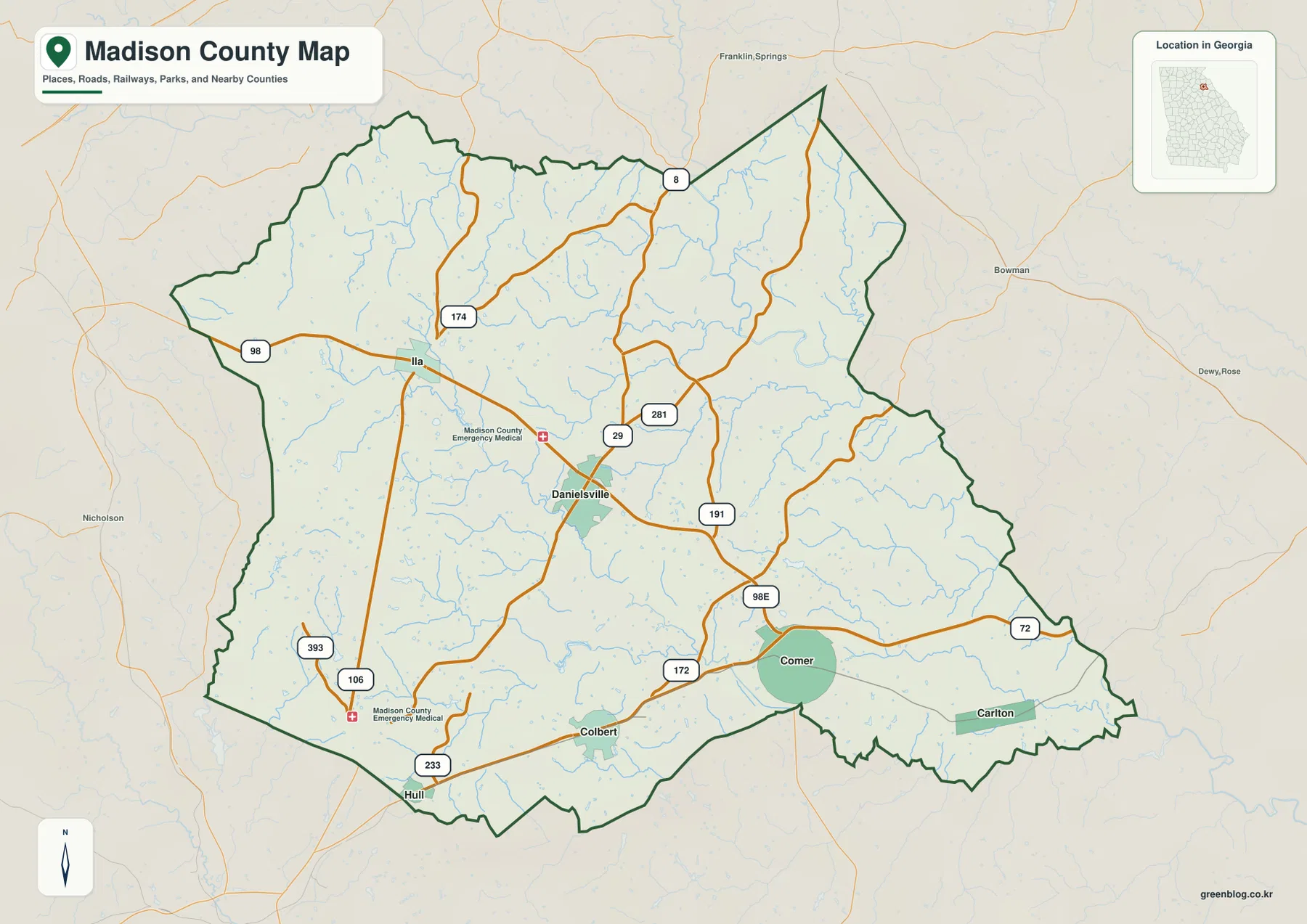
The city-distribution map simplifies the road detail so the relative positions of the six labeled municipalities stand out. Comer is in the southern-eastern part of the county, Danielsville is northwest of Comer near the center, and Hull and Colbert sit close to the southwestern boundary. Ila is farther northwest, while Carlton occupies the far southeastern side. Seen together, the places form a broad arc rather than a compact cluster around the county seat.
The City Index ranks Comer first, Danielsville second, Hull third, Colbert fourth, Ila fifth, and Carlton sixth. The ranking is useful as an index for the six places shown, but the map should not be treated as a statement about municipal area or travel time. Its main purpose is to make the distribution easy to read. Someone comparing Danielsville with the southern municipalities can see immediately that Hull and Colbert are grouped toward the southwest, whereas Comer and Carlton extend the chain toward the east.
County labels around the map provide another layer of orientation. Franklin County and Hart County appear along the northern side, Elbert County and Clarke County on the east, Oglethorpe County and Banks County toward the southwest and west, and Jackson County farther west. These surrounding labels help explain why Ila feels like a western reference point, why Carlton is close to the eastern edge, and why Hull and Colbert sit near the lower-left side of the county outline.
Broad River tributaries create a dense drainage network
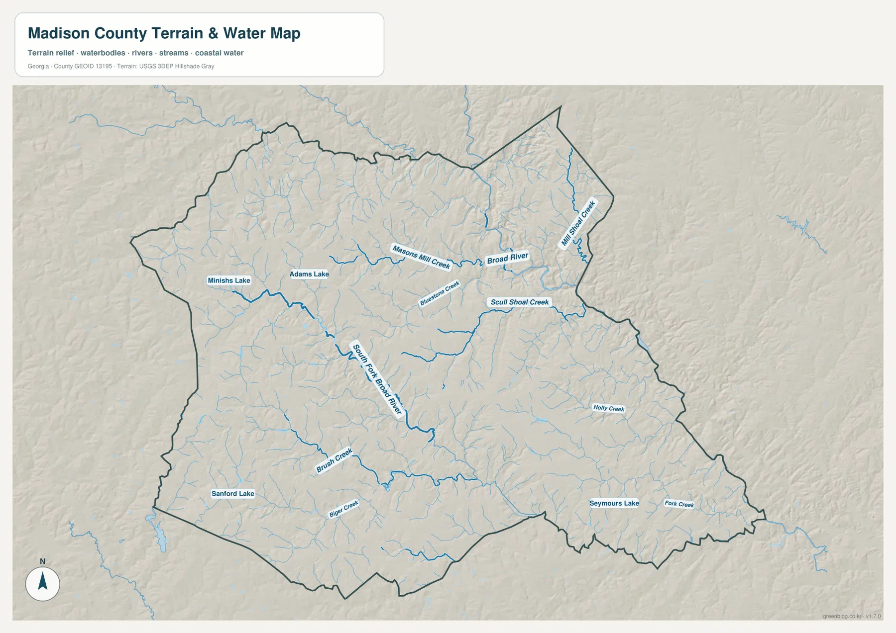
The water map reveals a much more intricate county than the road map alone suggests. Broad River is labeled across the northern and northeastern portion of the map, while South Fork Broad River runs through the central-western interior and connects with numerous smaller streams. Masons Mill Creek approaches the Broad River system from the west, and Bluestone Creek, Skull Shoal Creek, and Mills Shoal Creek are labeled across the northern and eastern parts of the county.
Additional named streams fill the southern half. Holly Creek appears in the east, Brush Creek and Bigger Creek are shown toward the southwest, and Fork Creek is labeled near the southeastern edge. The map also marks several small lakes, including Minishs Lake and Adams Lake in the west, Sanford Lake in the southwest, and Seymours Lake in the southeast. Together, these features show that surface water is distributed across the county rather than confined to one river corridor.
The terrain shading behind the blue lines makes the relationship between water and landform easier to see. Many small tributaries occupy narrow low areas between rounded ridges, then join larger channels. This is especially noticeable where the stream network branches repeatedly through the central and eastern parts of the county. The map is useful for geographic reference, but it is not a flood-zone map, legal water-boundary map, depth chart, or navigation product.
Higher western hills give way to lower eastern valleys
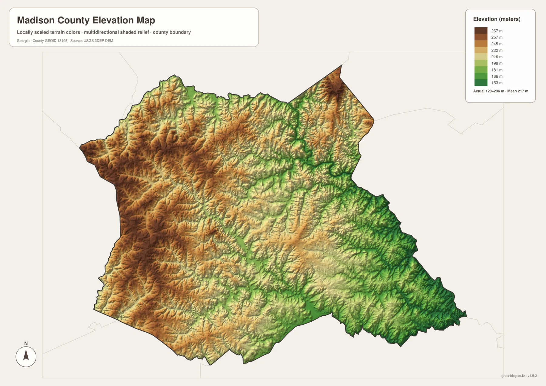
The elevation map uses locally scaled colors and shaded relief to show the county’s rolling terrain. Its legend gives an actual elevation range of about 120 to 296 meters, with a mean near 217 meters. Browns and oranges dominate much of the western side and several northern ridges, indicating higher ground. A high area also stands out near the northeastern tip. Greens become more common toward the eastern and southeastern portions, where lower valleys spread between the ridges.
The most useful detail is not simply which side is highest. Narrow green corridors branch through the county, tracing many of the same low valleys that appear as streams on the water map. The center contains a mix of moderate ridges and valleys, while the eastern half shows a denser network of lower channels. Looking back and forth between the two maps helps explain why the hydrography is so finely divided: the streams follow a landscape made of repeated ridges and shallow valleys rather than a single broad flat plain.
This elevation surface is designed for county-scale comparison. It should not be used as survey-grade elevation for a property, engineering design, or construction planning. For ordinary map reading, however, it clearly distinguishes the relatively high western uplands from lower eastern drainage corridors and shows how much local relief exists within a county whose absolute elevations are modest.
Roads, towns, water, and relief tell one county story
Danielsville is the natural starting point for reading the four maps because it is centrally located and appears where several main routes converge. From there, Ila lies to the northwest; Hull and Colbert are toward the southwest; and Comer and Carlton extend across the southern and southeastern side. The county map supplies the transportation frame, while the city view removes much of that detail so the settlement pattern is easier to compare.
The water and elevation layers explain what lies between those towns. South Fork Broad River and many creeks cross the rolling interior, while the eastern side contains numerous lower drainage lines. Western Madison County generally shows higher relief, but it is cut by valleys as well. This combination means that a town-to-town line on the city map crosses a landscape that is much more varied than the simplified settlement view suggests.
The earlier county material also identifies Madison County as a county established in 1811 and notes agriculture, poultry, Athens-area commuting, rivers, and Watson Mill Bridge State Park as part of its local context. Those points are useful background, but the supplied maps are countywide reference products rather than detailed park, tourism, or land-use maps. If a specific trail, property, local street, or park facility is the goal, these maps work best as the first orientation step before consulting a more detailed source.
Choose the map that matches the question
The general county map is the best starting point when roads, municipalities, and the county outline all matter at once. The city-distribution map is better when the main question is where the six municipalities sit relative to one another. For named rivers, creeks, and lakes, the water map provides the clearest labels. The elevation map is the most useful choice for comparing western uplands, eastern valleys, and the overall terrain range.
| Map | Best for |
|---|---|
| County map | Danielsville, numbered roads, municipalities, and county boundary |
| City map | Relative positions of Comer, Danielsville, Hull, Colbert, Ila, and Carlton |
| Water map | Broad River, South Fork Broad River, named creeks, and lakes |
| Elevation map | Comparing the roughly 120–296 m terrain range and major ridges and valleys |
For printing, close inspection, or use in a presentation, the downloadable files provide more detail than the WEBP previews shown on the page. The ZIP contains four original high-resolution A3 JPG files, one for each map type, so the maps can be used separately or compared side by side.
Frequently Asked Questions
Which six municipalities are labeled on the city map?
The city map labels Comer, Danielsville, Hull, Colbert, Ila, and Carlton. Danielsville is the county seat, while the other places are spread across the southern, western, and eastern parts of the county.
Which waterways stand out on the Madison County water map?
Broad River and South Fork Broad River are the most prominent named waterways. The map also labels Masons Mill Creek, Bluestone Creek, Skull Shoal Creek, Mills Shoal Creek, Holly Creek, Brush Creek, Bigger Creek, and Fork Creek, along with several small lakes.
What elevation range does the map show?
The elevation legend gives an actual county range of about 120 to 296 meters and a mean of about 217 meters. Higher terrain is most obvious in the west and parts of the north, while lower valleys are more widespread toward the east and southeast.
Sources and reference data
These official sources are useful for checking county information, boundaries, hydrography, and elevation data represented in the map set.
- U.S. Census Bureau QuickFacts for Madison County, Georgia
- U.S. Census Bureau TIGER/Line Shapefiles
- USGS National Hydrography
- USGS 3D Elevation Program
Map File Information
The ZIP contains four high-resolution A3 JPG maps of Madison County: county, city, water, and elevation views.
- Included Versions: County, city, water, and elevation
- Included Files: Four high-resolution A3 JPG maps
Related Maps
Green Map creates custom-edited map images using open geographic data sources such as geoBoundaries, Natural Earth, OpenStreetMap, and government open data. These maps are edited visual materials, not raw data files, and are provided for education, documents, presentations, and graphic reference.