Marion County in west-central Georgia is organized around Buena Vista, but the county becomes much more interesting once its roads, waterways, and relief are viewed together. The supplied maps show Buena Vista and Tazewell, numbered roads crossing a long and irregular county boundary, a dense network of creeks such as Pine Knot Creek, Oochee Creek, and Kinchafoonee Creek, and terrain ranging from roughly 102 to 245 meters in elevation. High-resolution A3 JPG versions of the county, city, water, and elevation maps are available to download together in one ZIP, while the page uses lighter WEBP previews for quick viewing.
The four views are most useful when they are treated as complementary references rather than repeated versions of the same map. The general county map makes Buena Vista a practical anchor for roads and boundary orientation. The city-distribution map strips away much of that detail and emphasizes only Buena Vista as the ranked major city. The water layer reveals numerous branching channels that are easy to miss on the road view, while the elevation layer explains why those channels occupy long green valleys between rounded ridges. Moving between the layers gives a clearer picture of a rural county shaped by many small drainage corridors rather than one dominant river or a broad flat plain.
Table of Contents
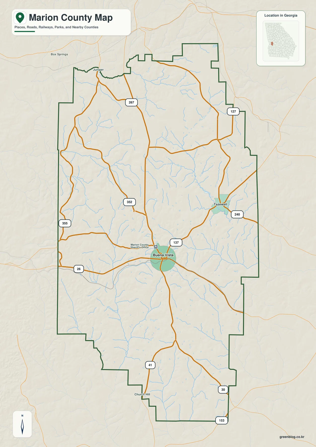
Buena Vista anchors the road map near the southern half of the county
On the general county map, Buena Vista is the easiest place to use as a starting point. It is the county seat and sits slightly south of the county’s midpoint, where roads marked 26, 41, and 137 meet or pass close by. From there, route numbers 352 and 267 provide references to the north, 355 appears toward the western side, and 240 runs near Tazewell to the northeast. Route 127 is shown in the northeastern portion, while 30 and 153 appear farther south and southeast. The pattern makes it possible to follow direction across the county without turning the map into a complete local-street atlas.
The boundary itself is long from north to south and has several stepped or indented sections. Neighboring county labels on the city map help place those edges: Talbot County lies to the north, Chattahoochee County, Webster County, and Stewart County are on the western side, and Schley County, Taylor County, and Sumter County are to the east and southeast. The general map also includes nearby labels such as Box Springs, Juniper, and Church Hill outside or near the county outline. These surrounding names are best used as orientation points rather than as a list of Marion County municipalities.
Tazewell is the other clear community label inside the county map and lies northeast of Buena Vista near the road marked 240. Its placement is useful because it gives the northern and eastern interior a second reference point. The map does not attempt to show every rural community, driveway, parcel line, or minor road. Instead, it provides the broad frame needed to understand where Buena Vista and Tazewell sit within the county and how the more important numbered routes cross the boundary.
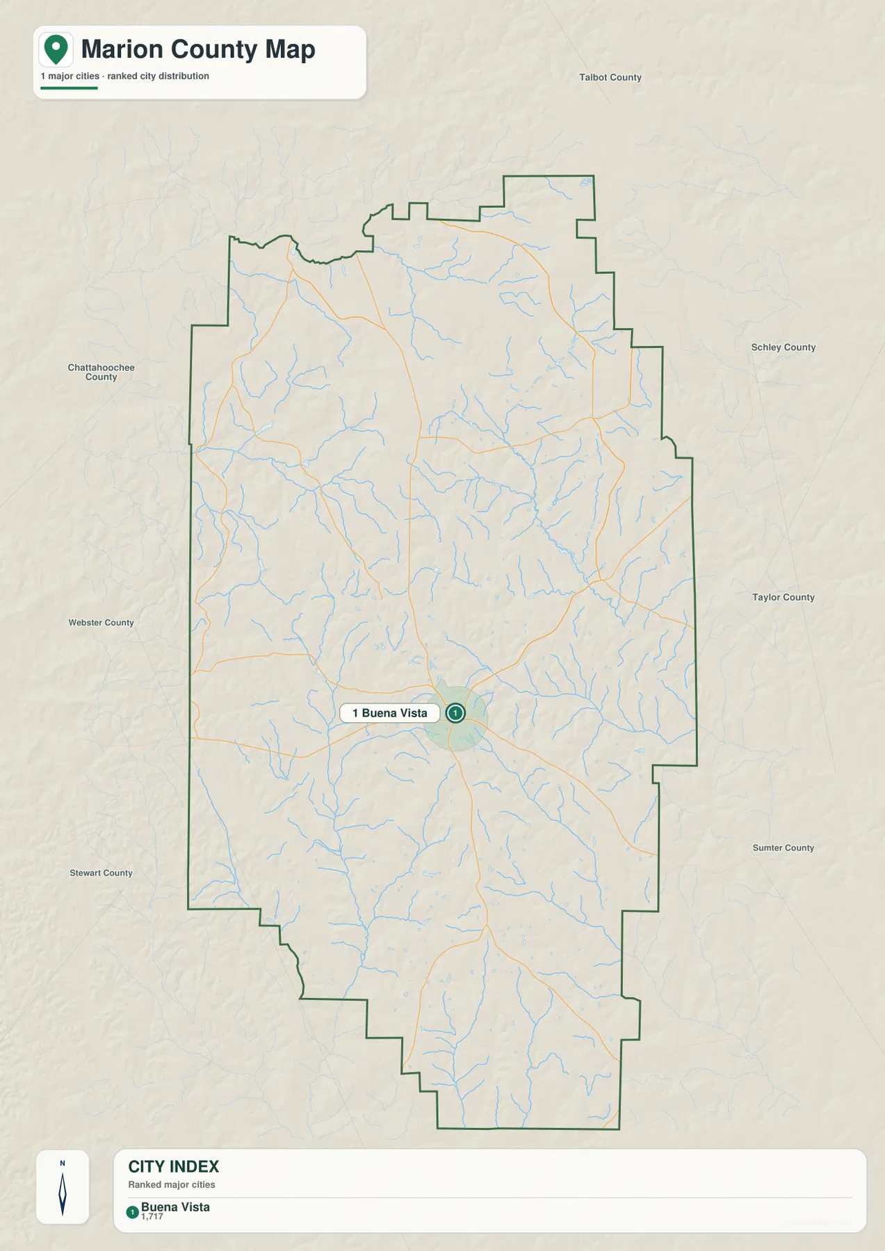
The city view narrows the county to one ranked major city
The city-distribution map looks intentionally sparse compared with the general map. Its heading states that one major city is included, and Buena Vista is the only place given a ranked city marker in the county. That does not mean Tazewell disappeared from the county or that no smaller communities exist. It simply reflects a different map purpose: the general map uses selected place names for orientation, while the city layer applies a narrower ranking and removes most other labels so the main settlement center is immediately visible.
Buena Vista’s position is also easier to judge on this simplified view. It sits below the county’s midpoint, leaving a large rural area to the north and a narrower southern section extending toward the lower boundary. Roads radiate away from the city in several directions, but the map does not show a chain of similarly sized municipalities spread across the county. For readers accustomed to more urban Georgia counties, this single-center pattern is an important distinction because it changes how the rest of the map should be read.
The surrounding county labels add useful geographic context. Talbot County is directly north, Schley and Taylor Counties lie to the east, Sumter County reaches the southeastern side, and Stewart, Webster, and Chattahoochee Counties line the west. These labels help explain where Buena Vista sits within the wider region even though the map is not intended for calculating driving mileage. No connector distance is shown here, so travel time and route length should be checked with a dedicated road or navigation source.
A branching creek network reaches nearly every part of Marion County
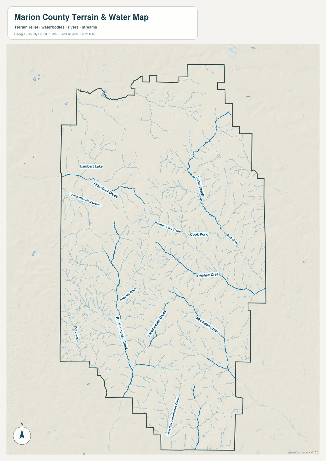
The water map changes the visual emphasis from roads to drainage. In the northwest, Lambert Lake appears near Pine Knot Creek, with Little Pine Knot Creek running nearby. Hardage Ford Creek is labeled closer to the middle, and Cook Pond provides another small water-body reference. Farther east, Oochee Creek collects a series of smaller tributaries before continuing toward the southeastern side. Even without following every unnamed blue line, the map makes clear that surface drainage is widely distributed rather than concentrated in a single channel.
The southern half is just as detailed. Kinchafoonee Creek runs through the southwestern interior, with Peacock Ditch and Dry Creek labeled in that part of the county. Lanahassee Creek and its West Fork appear farther south, while Muckalee Creek is labeled toward the southeast. Dozens of smaller tributaries branch into these named creeks, producing the tree-like pattern that dominates the water map. The effect is especially useful when compared with the general map, where the same waterways are present but are visually secondary to roads and place names.
This map should be read as a geographic water reference, not as a flood-hazard or navigation product. It does not provide flood probabilities, regulatory floodplain boundaries, water depth, legal riparian boundaries, or safe boating information. Its value is in showing where named creeks and ponds lie, how many small tributaries feed them, and how the drainage network relates to the county’s terrain. Those questions become even clearer when the water layer is compared with the elevation map.
Elevation from about 102 to 245 meters reveals ridges between the creeks
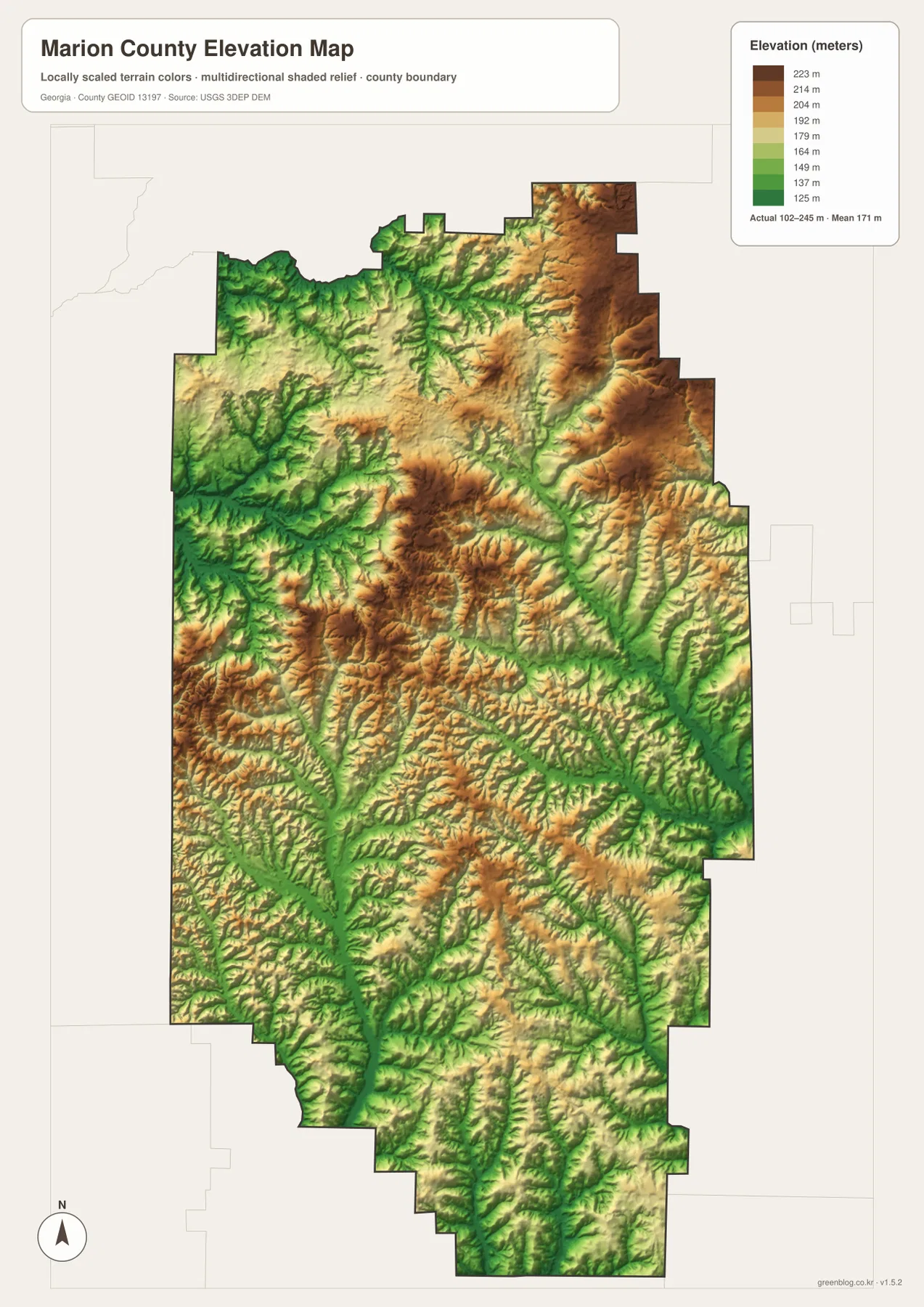
The elevation map shows an actual displayed range of about 102 to 245 meters, with a mean near 171 meters. Marion County is not presented as mountainous terrain; instead, the shaded relief is made up of repeated low valleys and rounded uplands. A broad area of higher brown terrain stands out in the northeast, and another elevated belt appears through the west-central interior. Between those areas, narrow green corridors cut across the map and create a fine-grained pattern of ridges and hollows.
Those green corridors line up closely with many of the streams shown on the water map. The Pine Knot Creek and Kinchafoonee Creek systems occupy lower terrain in the western half, while Oochee Creek and the southeastern tributaries trace other low paths through the county. The central area does not simply slope in one direction. It alternates between higher ridges and lower drainage lines, which explains why the hydrography branches so repeatedly and why the terrain texture looks much more complex than a flat county outline would suggest.
The locally scaled colors are best used for relative comparison inside Marion County. They help identify higher ridges, lower stream valleys, and the general amount of local relief, but they should not be treated as survey-grade elevations for a specific lot or construction site. Engineering, property, and precision surveying work requires more detailed source data. For ordinary county geography, however, the map makes the relationship between creeks and landform immediately visible.
Reading the layers together explains more than any single map
Buena Vista is the logical anchor for combining the maps. The county layer shows the roads that meet around the seat, while the city layer removes most competing labels and makes its position within the long county outline obvious. Switch to the water layer and the open space between those roads fills with tributaries. Then the elevation layer shows that many of those tributaries follow lower green valleys separated by ridges. The same location therefore looks simple on one map and highly textured on another, depending on the question being asked.
Tazewell is a good example of why the layers should not be expected to contain identical labels. It appears on the general map as a useful northeastern community reference, but the city-distribution view is restricted to Buena Vista as the ranked major city. Likewise, the basic map contains streams but does not label them with the same density as the water layer, and it shows terrain shading without the numeric elevation legend available on the elevation map. Each layer sacrifices some information so that another kind of information can be easier to see.
The current county material also notes that Marion County was established in 1827 and identifies Pasaquan as part of its cultural context. Those details are useful background, but the downloadable map set is designed for county-scale geography rather than a site plan for a particular attraction. If the goal is to visit Pasaquan or another specific destination, the county map can provide general orientation around Buena Vista, after which a local road map or the destination’s own directions should be used for the final approach.
Choose the map by the question you need to answer
The general county map is the strongest choice for seeing Buena Vista, Tazewell, major numbered roads, streams, and the county boundary in one frame. The city view is better when the goal is simply to locate Buena Vista within the county without extra labels. For named waterways such as Pine Knot Creek, Oochee Creek, Kinchafoonee Creek, and Lanahassee Creek, the water map provides far more detail. The elevation map is the clearest option for comparing the 102–245 meter relief and seeing where green stream valleys cut between higher ridges.
| Map | Best for |
|---|---|
| County map | Buena Vista, Tazewell, numbered roads, boundary, and overall orientation |
| City map | Buena Vista as the ranked major city and its position within the county |
| Water map | Named creeks, ponds, tributaries, and their relationship to terrain |
| Elevation map | About 102–245 m of relief, higher ridges, and lower drainage valleys |
WEBP previews are convenient for reading the page, but the original JPG files are more appropriate when you want to print, enlarge, or compare details side by side. The ZIP below contains four high-resolution A3 JPG maps covering the same county from the county, city, water, and elevation perspectives. You can keep the complete set together or use only the file that matches your immediate task.
Frequently Asked Questions
Why does Tazewell appear on the county map but not on the ranked city map?
The general county map includes selected community names that help with orientation, so both Buena Vista and Tazewell are labeled there. The city-distribution map uses a narrower major-city ranking and highlights only Buena Vista. The two views are therefore showing different levels of place information rather than conflicting with each other.
What are the long green corridors on the elevation map?
Green represents the lower end of the county’s locally scaled elevation range. Many of the long green corridors follow the same general paths as creeks on the water map, so they are useful for recognizing lower drainage valleys between ridges. They are not precise property-level elevation boundaries.
Can the water map be used to identify flood-risk zones?
No. It is a terrain and water-reference map showing named streams, ponds, and tributaries. It does not display regulatory floodplains, flood probabilities, water depths, or legal property boundaries, so official flood-hazard sources should be used for those decisions.
Sources for county, boundary, water, and elevation context
The county-specific references below provide general Marion County background, while the federal data pages document widely used boundary, hydrography, and elevation sources relevant to the map themes.
- U.S. Census Bureau QuickFacts – Marion County, Georgia
- New Georgia Encyclopedia – Marion County
- U.S. Census Bureau TIGER/Line Shapefiles
- USGS National Hydrography
- USGS 3D Elevation Program
Map File Information
This ZIP contains high-resolution A3 JPG versions of the Marion County county map, city map, water map, and elevation map.
- Included Versions: County, city, water, and elevation
- Included Files: Four high-resolution A3 JPG maps
Related Maps
Green Map creates custom-edited map images using open geographic data sources such as geoBoundaries, Natural Earth, OpenStreetMap, and government open data. These maps are edited visual materials, not raw data files, and are provided for education, documents, presentations, and graphic reference.