Washington County sits in east-central Georgia, with Sandersville and Tennille forming the most obvious central pair on the supplied maps. Sandersville is the county seat and the clearest road hub, while Davisboro and Riddleville lie to the east, Deepstep to the west, Oconee to the southwest, and Harrison to the south. Warthen appears north of Sandersville on the general county map, giving another useful reference point for the northern part of the county. This page explains the county, city, water, and elevation maps separately, and you can download all four maps as high-resolution A3 JPG files in one ZIP.
The landscape becomes much easier to understand when the water and elevation maps are viewed beside the road map. The Oconee River follows the western and southwestern side of the county, while the Little Ogeechee River is labeled in the north. Farther south, the Ohoopee River and Little Ohoopee River drain different parts of the county, with named creeks and millponds filling the space between them. The elevation image gives an actual county range of about 56 to 169 meters and a mean of about 111 meters. Higher rolling ground covers much of the center and northwest, while river corridors and stream valleys form lower green bands.
The existing county background material also notes that Washington County was established in 1784 and has long been associated with kaolin mining, rail transportation, agriculture, forestry, and regional services. Those facts help explain the county’s local context, but the maps on this page are not mining-property or industrial-facility maps. They are designed to show the county boundary, selected towns, numbered roads, named water features, and broad elevation differences. That distinction matters if you are using the page for local orientation rather than for parcel, permit, or industrial-site research.
Table of Contents
Roads radiating from Sandersville and Tennille across the county
The general county map makes Sandersville the easiest place to start. Several numbered roads meet in or near the city and then spread toward other parts of Washington County. Routes marked 88 and 540 run east from the Sandersville area toward Davisboro, while Route 15 continues south through Tennille toward Harrison. North of Sandersville, Warthen sits along a north-south corridor with a 102 marker nearby. In the southeast, 231 and 242 help locate the Riddleville and Harrison side of the county, while 272, 68, and 57 appear in the southwest toward Oconee.
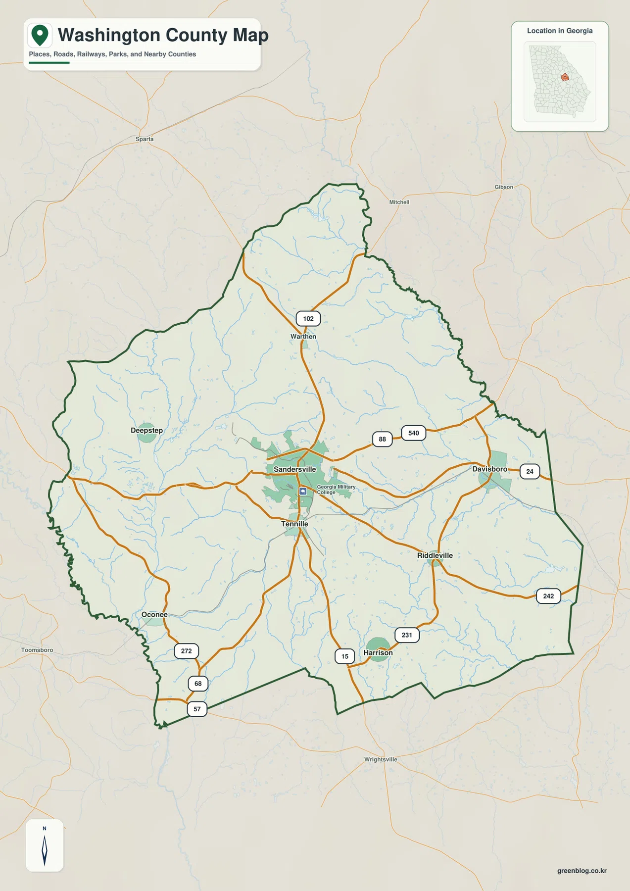
Sandersville and Tennille are close together on the map, but the other labeled places spread across a much larger area. Davisboro sits near the eastern side of the county, with a 24 marker visible nearby. Riddleville lies farther south and connects to an east-west road marked 242. Deepstep is well west of Sandersville, while Oconee is in the southwest and Harrison is south of the central pair. The result is not a county where all towns line up along a single corridor. Instead, Sandersville works as the central reference point for several different directions of travel.
The county outline is also worth noticing. The northern end narrows, while the eastern and southern edges turn through several angles rather than forming a simple rectangle. Outside the boundary, the general map labels places such as Sparta, Mitchell, Gibson, Wrightsville, and Toomsboro. The city map adds nearby county names, including Hancock County to the north, Johnson County to the northwest, Glascock County to the west, Wilkinson County to the southwest, Jefferson and Baldwin counties to the east, and Warren County to the southeast. These surrounding labels are useful for orientation, but the map should not be treated as a parcel or legal-boundary survey.
The concentration of roads around Sandersville fits the settlement pattern shown on the other maps. Tennille is immediately south, while Davisboro and Riddleville extend the populated references eastward. Deepstep and Oconee give the western half of the county its own reference points, and Harrison marks the southern area. Looking at the road network this way is more useful than memorizing town names in isolation because it shows how each place relates to the central hub and to the county edge.
Six highlighted communities from Sandersville to Deepstep
The city map removes much of the road detail and highlights six places with numbered markers. Sandersville is number 1 in the center, Davisboro is number 2 to the east, and Tennille is number 3 just south of Sandersville. Harrison appears as number 4 in the south, Oconee as number 5 in the southwest, and Deepstep as number 6 in the west. Riddleville and Warthen, which are visible on the general map, are not part of this six-place ranking, so comparing the two maps helps distinguish the broader place labels from the city map’s selected set.
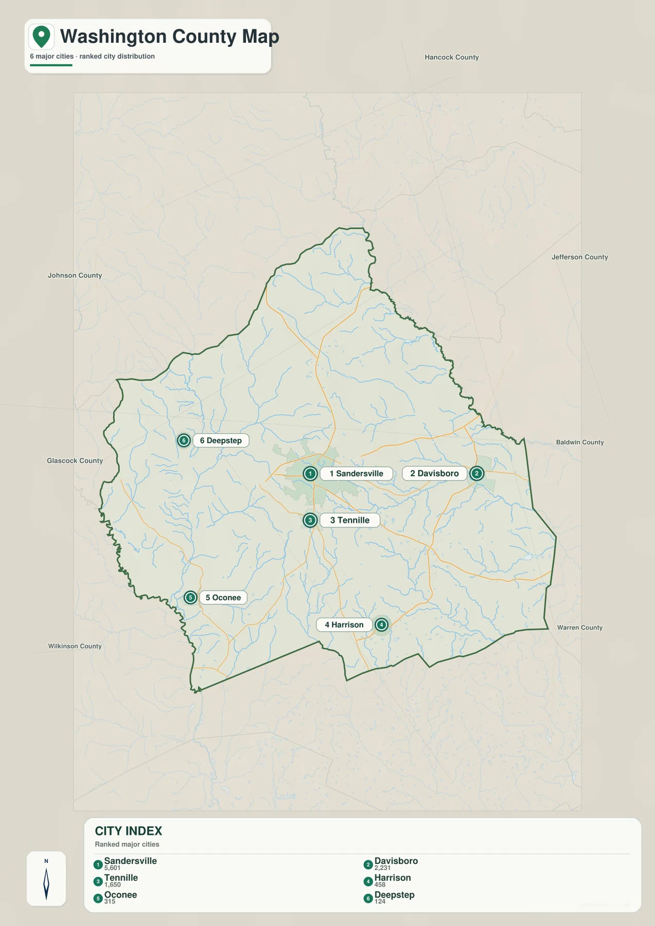
The city index printed on the map shows values of 5,601 for Sandersville, 2,231 for Davisboro, 1,650 for Tennille, 458 for Harrison, 315 for Oconee, and 124 for Deepstep. Because the image does not state a reference year next to those values, they are best treated as the figures used by this particular map rather than as a claim about the latest population estimate. Even with that limitation, the ranking makes the relative scale of the highlighted places clear. Sandersville stands apart as the largest value and also appears as the strongest road center on the general map.
The east-west spread is especially useful for understanding Washington County. Davisboro sits near the eastern side and provides a practical reference for the Jefferson and Baldwin County direction. Oconee and Deepstep occupy the western side, closer to the lower terrain associated with the Oconee River system. Harrison and Tennille are both south of Sandersville, but Harrison is much farther toward the county’s southern edge. These differences make the city map useful when a presentation or class needs a clean answer to where the principal labeled communities sit relative to one another.
Sandersville and Tennille deserve special attention because they are so close on the map. Sandersville has the denser road pattern and the Georgia Military College label nearby, while Tennille sits directly to the south on the route marked 15. The city map should not be read as a municipal-boundary map; its circles identify locations rather than the actual built-up area of each city. For municipal limits, neighborhood boundaries, or addresses, a more specialized source would be required.
From the Oconee River to the Ohoopee system: streams, ponds, and low corridors
The water map gives Washington County a much different appearance from the road map. The Oconee River is the most prominent large river along the western and southwestern side of the county. In the north, the Little Ogeechee River is labeled as a separate system. The Ohoopee River runs through the south-central area, while the Little Ohoopee River crosses the southeast. Seeing these names together makes it clear that the county is divided among several drainage systems rather than being organized around one single river.
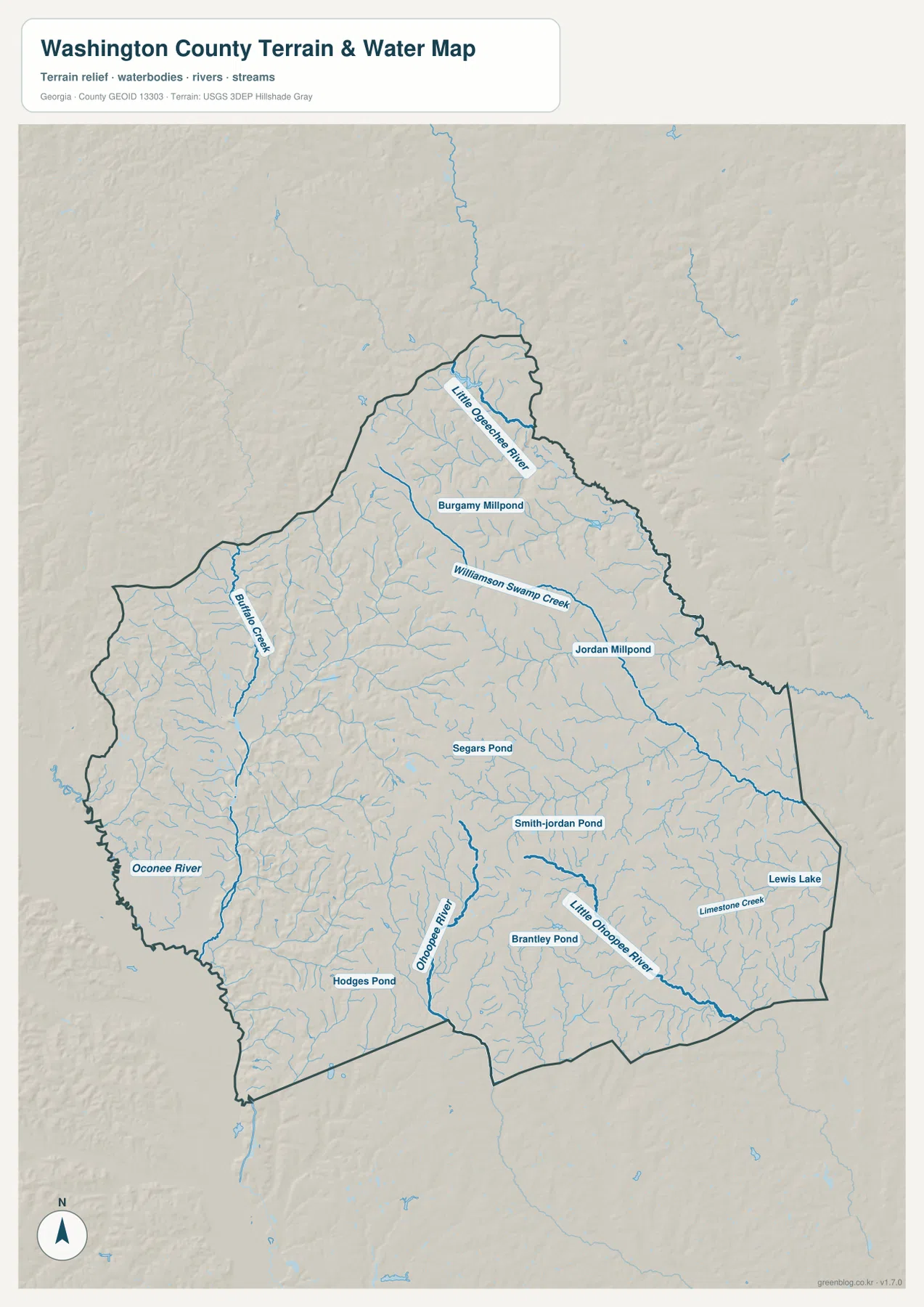
Smaller named features fill in the gaps between the major rivers. Buffalo Creek runs through the western side, and Williamson Swamp Creek crosses the north-central area. Limestone Creek appears in the southeast near the Little Ohoopee River. Jordan Millpond and Burgamy Millpond are labeled in the northern and eastern half, while Segars Pond, Smith-Jordan Pond, Brantley Pond, Hodges Pond, and Lewis Lake are scattered farther south and east. The map therefore shows a dense network of small streams and impoundments that is easy to miss when viewing only the general road map.
Place names help connect this water network to the settlement map. Oconee is in the southwestern part of the county near the broader Oconee River side. Around Sandersville and Tennille, many smaller tributaries spread through the central terrain rather than one dominant river channel. Davisboro and Riddleville provide useful eastern reference points for the Little Ohoopee and Limestone Creek side of the county. Warthen helps orient the northern portion near the Little Ogeechee River. The nearest named water feature therefore changes depending on which town you use as your starting point.
This water image is a location reference, not a flood-risk, water-quality, or streamflow map. A property near the Oconee River or Ohoopee River cannot be classified as flood-prone simply from this graphic, and the size of a blue line does not provide a discharge measurement. If a project requires current flood zones, water conditions, or engineering data, the appropriate official source should be consulted. Here, the useful task is to see where the named rivers and creeks run and how they line up with the low valleys on the elevation map.
A 56–169 meter landscape of rolling uplands and river valleys
The elevation map reports an actual range of about 56 to 169 meters and a mean of about 111 meters for Washington County. Browns and darker orange tones cover many of the central and northwestern uplands, while green bands follow lower ground. The western Oconee River corridor is one of the clearest low areas, and additional low valleys appear along streams in the east and south. Washington County is not mountainous, but the shaded relief shows that it is far from uniformly flat. Ridges and drainage valleys repeat across much of the county.
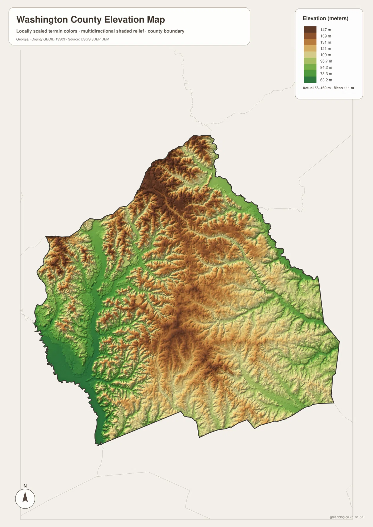
The western side is the easiest place to see the relationship between water and elevation. The Oconee River follows a long low corridor colored deep green, while higher rolling ground rises to the east. Buffalo Creek also occupies a lower valley within the western half of the county. Around Sandersville and Tennille, the terrain mixes moderate and higher elevations with narrow stream valleys. Farther south, the Ohoopee River creates another low route through the landscape, and the Little Ohoopee River is associated with lower terrain in the southeast.
The northern part contains substantial higher ground, but it is not one continuous high block. The Little Ogeechee River and its tributaries cut lower paths through the uplands, producing long green notches between brown ridges. A similar pattern appears across the center and east wherever tributaries occupy lower ground. This is why the county is better described as rolling terrain broken by stream valleys than as a simple north-high, south-low slope.
The elevation image is intended for county-scale comparison, not site surveying. The 56–169 meter range describes the broad relief visible in the supplied data. It does not replace a surveyed elevation for a parcel, a road grade, or a building site. For a general map page, the most useful takeaway is that the Oconee River and other waterways tend to occupy lower corridors, while higher ridges cover much of the interior and northwest.
Using the four maps together for Washington County
The four maps answer different parts of the same geographic question. Sandersville is the central road reference on the general map and the number 1 place on the city map. Around it, the water image reveals a web of smaller tributaries, while the elevation image shows rolling ground divided by narrow valleys. Following one place across all four views turns an abstract county outline into a more understandable landscape of roads, towns, waterways, and changing height.
For the western half, Deepstep and Oconee are useful anchors. Both lie west or southwest of Sandersville, where the water map becomes increasingly influenced by the Oconee River and Buffalo Creek. The elevation map then shows why this side looks different: the river corridor is much lower than the rolling ground immediately to the east. This comparison is useful when explaining that western Washington County contains both low river terrain and higher ridges rather than one flat surface.
Davisboro and Riddleville provide a similar way to read the east. The general map places both communities along the eastern road network, while the water map highlights the Little Ohoopee River and Limestone Creek system farther southeast. The elevation map shows alternating low drainage corridors and higher uplands near that side of the county. Instead of describing Davisboro or Riddleville only by direction from Sandersville, the maps let you add the surrounding water and terrain to the explanation.
The county’s kaolin history is an example of why map purpose matters. The existing background sources identify kaolin mining and rail transport as important parts of Washington County’s local economy, but these four images do not map mine boundaries, processing plants, rail freight facilities, or mineral ownership. They can still provide a geographic starting point by showing where Sandersville and Tennille sit within the county and how major roads spread from the center. Any detailed industrial investigation should then move to specialized official or industry sources.
- County map: best for Sandersville, Tennille, Davisboro, Riddleville, Deepstep, Oconee, numbered roads, and the county boundary
- City map: best for comparing the six highlighted communities and the map’s printed ranking values
- Water map: best for the Oconee River, Little Ogeechee River, Ohoopee and Little Ohoopee rivers, creeks, ponds, and Lewis Lake
- Elevation map: best for the 56–169 meter range, rolling uplands, and lower river and stream corridors
The WEBP images in the article are lightweight previews for the page. If you need larger labels or a printable version, use the ZIP below. It contains a separate A3 high-resolution JPG for the county, city, water, and elevation map, so you can select only the view you need or place several side by side in a report, classroom handout, or presentation.
These maps are county-level reference materials rather than parcel surveys, live navigation, flood determinations, or mining-permit maps. For legal boundaries, current hydrography, precise elevations, or specialized industrial information, consult the relevant official datasets and county sources listed below.
Frequently Asked Questions
How are Sandersville and Tennille positioned within Washington County?
They are very close together in the central part of the county. Sandersville is the stronger road hub, and Tennille lies directly to its south. The general and city maps therefore make the two places look like a closely connected central pair while still labeling them separately.
Where are the Oconee and Ohoopee rivers on the map?
The Oconee River is most prominent along the western and southwestern side of Washington County. The Ohoopee River runs through the south-central area, while the Little Ohoopee River lies farther southeast. On the elevation map, these river and stream corridors generally follow lower terrain than the surrounding rolling uplands.
What files are included in the Washington County map download?
The ZIP contains four high-resolution A3 JPG files: a county map, city map, water map, and elevation map. The WEBP images in the article are smaller page previews, while the JPG versions are intended for larger viewing and printing.
Map File Information
The ZIP contains separate A3 high-resolution JPG files for the Washington County county map, city map, water map, and elevation map. Use the larger files when you need clearer labels for printing, class materials, research notes, or presentations.
- Included Files: County map, city map, water map, elevation map
- File Type: ZIP containing four high-resolution A3 JPG files
Related Maps
Sources and References
The following sources provide additional Washington County background and official data references for boundaries, hydrography, and elevation. Use the most current agency material when a project requires more precision than a county reference map can provide.
- U.S. Census Bureau QuickFacts — county-level statistics and reference information
- Official Washington County history page — county history and local background
- New Georgia Encyclopedia: Washington County — historical and economic context
- U.S. Census Bureau TIGER/Line Shapefiles — boundary and road reference data
- USGS National Hydrography — river, stream, and water-feature reference data
- USGS 3D Elevation Program — elevation and terrain reference data
Green Map creates custom-edited map images using open geographic data sources such as geoBoundaries, Natural Earth, OpenStreetMap, and government open data. These maps are edited visual materials, not raw data files, and are provided for education, documents, presentations, and graphic reference.