Wayne County in southeastern Georgia is easiest to understand by starting with Jesup and then following the roads, streams, and county boundary outward. Jesup sits near the center of the mapped road network, while Screven lies to the southwest and Odum to the west. You can download all four Wayne County maps as high-resolution A3 JPG files in one ZIP from the map-file box below. The page previews let you compare places, transportation, water, and elevation before choosing the files you need.
The maps show a county with more internal variety than a simple outline suggests. Several numbered highways meet around Jesup, local streams form a dense network away from the city, and the elevation surface changes from relatively higher ground in the west and northwest to lower terrain across much of the east and southeast. The Altamaha River is part of the county’s broader geographic context along its northeastern side, while the water map adds smaller named creeks, lakes, and old channels that are easy to miss on a general road map.
Table of Contents
Jesup anchors a road network inside an irregular county boundary
The general county map makes Jesup the clearest reference point. Routes labeled 84, 169, 203, 341, 27, 25, 23, and 301 approach or pass through different parts of the county, with several of them converging in and around Jesup. This creates an obvious hub on the map even before the city labels are read. Odum appears west of that hub, Screven is southwest, and Gardi is marked southeast of Jesup on the more detailed county view.
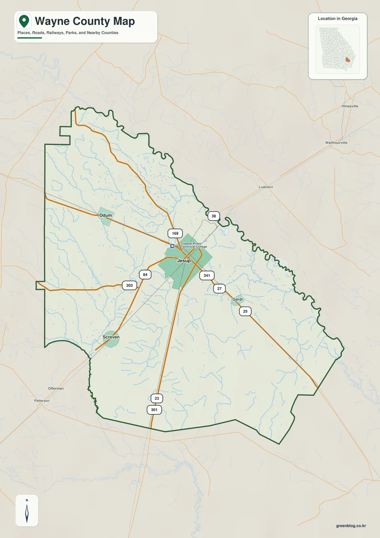
The county outline itself is worth noticing. The northern and northeastern edge is strongly curved, while the western and southern sides include long straight sections broken by several steps and bends. Because the boundary is not a simple rectangle, a map is more useful than a verbal description when comparing Wayne County with its neighbors. The companion city map places Pierce County to the west, Brantley County to the northwest, Long County to the north, Glynn and Appling counties to the east, McIntosh County to the southeast, and Tattnall County to the southwest.
Jesup is the county seat and is identified in the existing source material as the largest city in Wayne County. The county was established in 1803, and the source package also points readers to the City of Jesup’s official history page for local background. For map use, the important point is not to turn those historical facts into a separate timeline; it is to understand why Jesup remains the natural starting point when locating roads, nearby communities, and the rest of the county.
Jesup, Screven, and Odum form a simple three-place reference pattern
The city-focused map strips away some of the extra labels and makes the spacing between the main mapped places easier to see. Jesup remains the hub in the middle. Screven is positioned southwest near the lower-left side of the county, while Odum is west of Jesup. The connection panel on the map uses Jesup as the hub and gives direct-distance figures for Screven and Odum, reinforcing the idea that the two smaller cities sit in different directions from the county seat rather than along one single line.
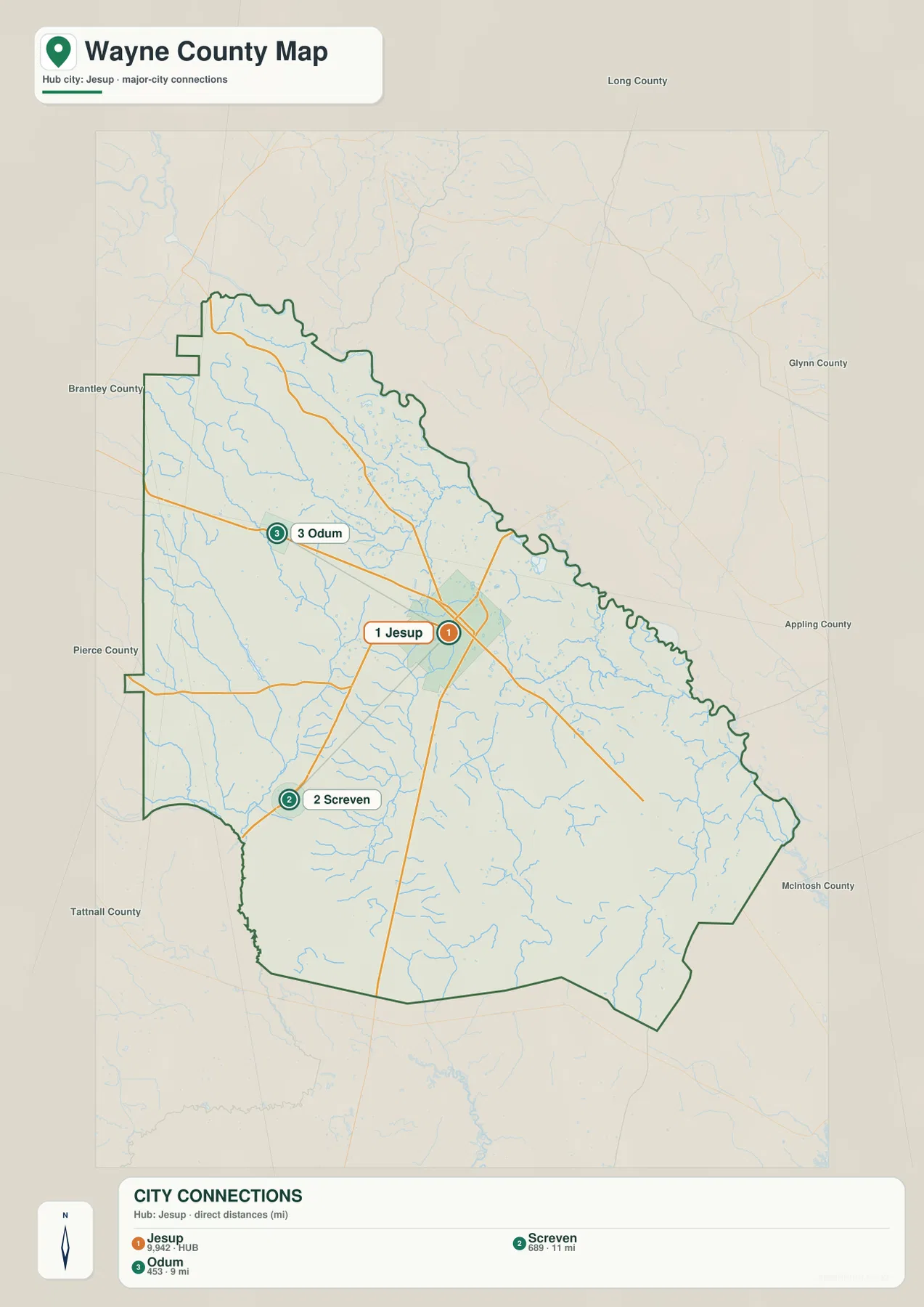
Road direction adds useful context to those positions. A southwest route connects the Jesup area toward Screven, while the west-running corridor points toward Odum. Routes 23 and 301 continue south through the county, and the 341 and 27 labels help define the eastward side of the network. The purpose of this map is not turn-by-turn navigation. It is a compact way to understand which places lie in the same general direction and where a traveler or researcher should begin when moving from a county-scale view to a more detailed road source.
Not every community is included. Gardi appears on the general map but is not part of the three-place city-connection graphic, and many smaller unincorporated locations are outside the scope of both views. That distinction matters for genealogy, address research, and local history: these maps are useful for orientation, but a missing place name should not be interpreted as proof that a community does not exist.
The Altamaha edge is only part of Wayne County’s water story
The source material identifies the Altamaha River as one of Wayne County’s defining geographic features, associated with the curved northeastern side of the county. The dedicated water map then shifts attention inward, where a much denser set of named creeks, river branches, lakes, and old channels becomes visible. This is useful because a county can be strongly associated with one major river while still having most of its local drainage expressed through smaller waterways.
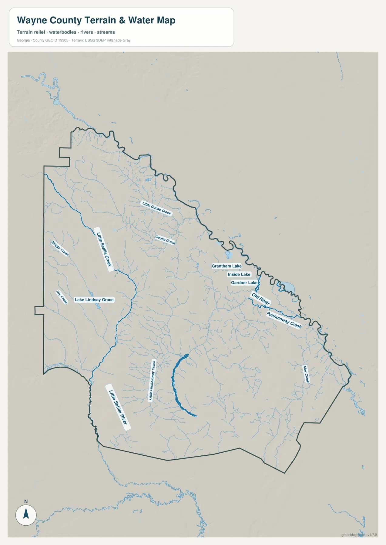
On the western side, Little Satilla Creek runs southward toward the Little Satilla River, which continues near the southwest part of the county. Beedy Creek and Big Creek are also labeled in the west. Farther north and toward the center, Little Goose Creek and Goose Creek appear among many smaller tributaries. These labels give the western half of the county a noticeably branched appearance when compared with the cleaner road map.
The eastern half has its own set of water features. Penholloway Creek and Mink Creek are labeled toward the east and southeast, while Little Penholloway Creek appears farther south and closer to the middle. Grantham Lake, Inside Lake, and Gardner Lake form a small cluster in the northeast, with Old River nearby. Lake Lindsay Grace is labeled on the western side. The result is a map that is useful for locating named water features and for seeing how much of Wayne County lies between small drainage lines rather than around a single large lake.
This water map should not be used as a flood-risk or navigation chart. It does not tell the reader whether a stream is navigable, how deep a lake is, or what land may flood during a particular event. Its strength is location: it provides a county-wide reference for water names and lets readers compare those locations with roads, towns, and the elevation surface.
A low-elevation county still has a visible west-to-east contrast
The elevation map reports an actual range of about 1 to 71 meters, with a mean elevation of roughly 27 meters. Those figures show that Wayne County is low in absolute terms, but the locally scaled colors make internal differences easy to see. Broad brown and tan areas cover much of the west and northwest, while green becomes more extensive through the center, east, and southeast.
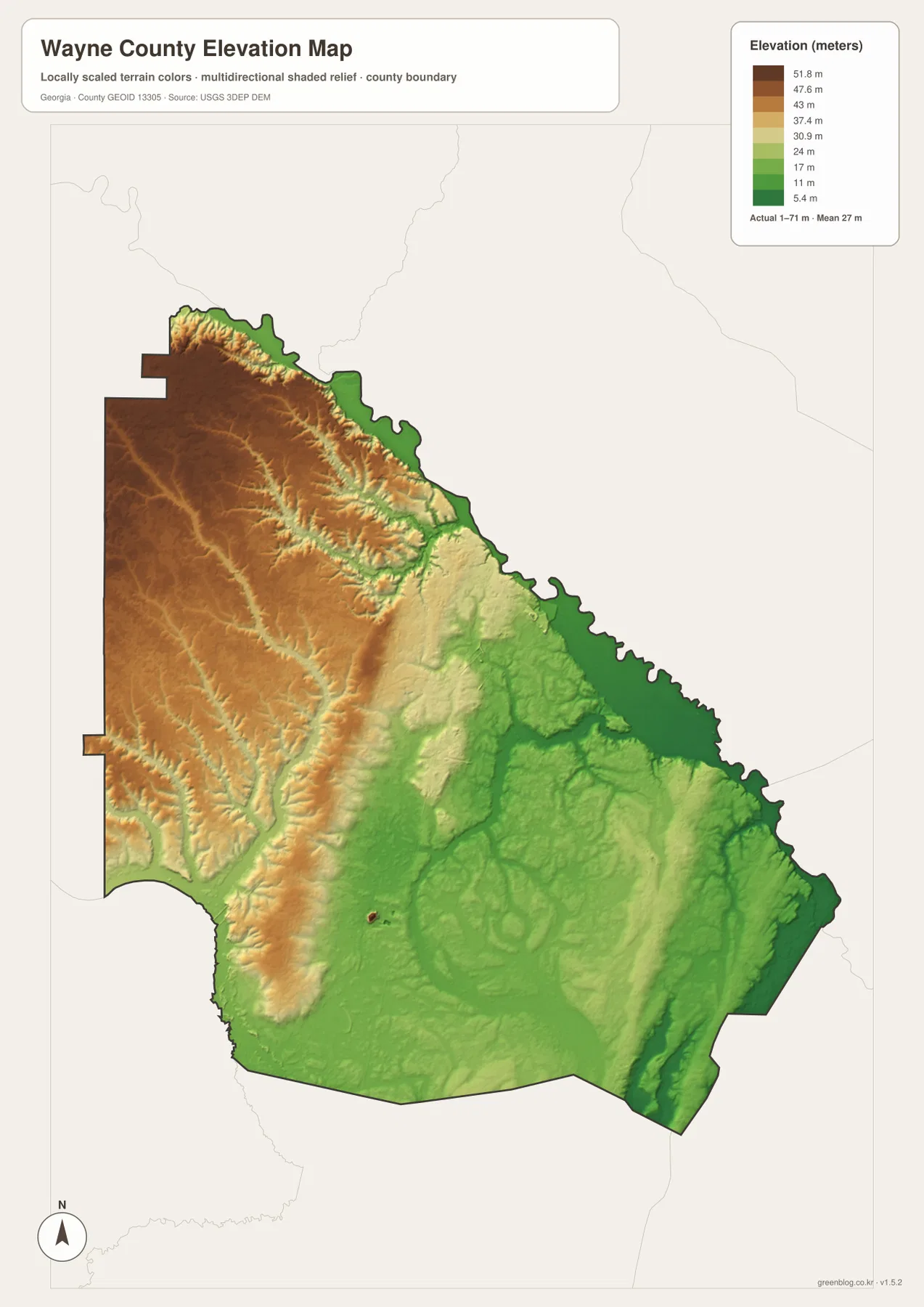
The western high side is not a single smooth plateau. Shaded relief reveals many narrow cuts and small valleys running through the higher surface. Across the middle and east, the lower colors spread more broadly, and darker green drainage lines stand out in several places. When the elevation and water maps are compared, some of the stream corridors line up with those lower parts of the terrain, which helps explain why the hydrography looks so extensive.
The color contrast should be read relative to Wayne County, not as a comparison with mountain counties elsewhere in Georgia. A dark brown area here is simply high within this local 1–71 meter range. That distinction prevents a common map-reading mistake: strong colors can make modest relief appear dramatic even when the actual elevation numbers remain low.
Choose the map that matches the question, then use the JPG set offline
The four views are most useful when they are treated as complementary. Start with the county map for boundaries and highway orientation. Use the city view when the main question is where Jesup, Screven, and Odum sit relative to one another. Switch to the water map for creek and lake names, and use the elevation map when the location of higher and lower ground matters more than road labels.
| Question | Best map | Useful details |
|---|---|---|
| Where are the main roads and places? | County map | Jesup, highway numbers, county outline, nearby places |
| How are the mapped cities spaced? | City map | Jesup, Screven, Odum, neighboring counties |
| Where are named creeks and lakes? | Water map | Little Satilla system, Goose Creek, Penholloway Creek, lakes |
| Which parts are relatively higher or lower? | Elevation map | 1–71 m local range and west-to-east contrast |
The page previews are WEBP files so they load efficiently in a browser. For printing, archiving, classroom work, reports, or image editing, the download package is more convenient. It contains the same four subjects as high-resolution A3 JPG files in a single ZIP, so the files can be saved and used without returning to the webpage.
What these county maps do not replace
These maps are county-scale reference images, not parcel, property, zoning, or address maps. The city view deliberately focuses on a small number of labeled places, and the road view does not include every local street or driveway. If the task is to locate a specific home, legal boundary, school zone, or service address, use a source designed for that level of detail after establishing the general location here.
The same limitation applies to water and elevation. The hydrography view locates named streams and lakes but does not provide flood probabilities, water depth, or boating conditions. The elevation view is excellent for county-wide relief and relative height, but it is not a substitute for engineering or survey-grade measurements. Used within those limits, the four maps provide a clear way to move from a simple question—where is Wayne County?—to more specific questions about towns, rivers, drainage, and terrain.
The source links below provide a path to more authoritative detail. Census resources support county identity and demographic reference, the City of Jesup page offers local historical context, TIGER/Line is a standard source for geographic boundaries and roads, and USGS resources cover hydrography and elevation data. Keeping those sources separate from the simplified map presentation makes the page easier to read while still giving readers a way to continue their research.
Frequently Asked Questions
Where are Screven and Odum in relation to Jesup?
Jesup is shown near the center of the mapped road network. Screven lies to the southwest, while Odum is west of Jesup. The city map is the quickest view for comparing those directions, and the general county map adds the main highway connections.
How much elevation change does the Wayne County map show?
The elevation graphic lists an actual range of about 1 to 71 meters and a mean near 27 meters. The west and northwest are relatively higher, while lower colors cover much of the east and southeast. The difference is meaningful within the county even though the overall elevations are low.
What is included in the Wayne County map download?
The ZIP contains four high-resolution A3 JPG files: a county map, city map, water map, and elevation map. The WEBP images on the page are lighter browser previews, while the JPG files are intended for saving, printing, and offline use.
Sources and Reference Data
- U.S. Census Bureau QuickFacts for Wayne County, Georgia
- City of Jesup official history
- U.S. Census Bureau TIGER/Line geographic files
- USGS National Hydrography
- USGS 3D Elevation Program
Map File Information
Download the Wayne County county, city, water, and elevation maps as high-resolution A3 JPG files in one ZIP archive.
- File Type: Four high-resolution A3 JPG files in a ZIP
Related Maps
- Wayne County Tennessee map | Waynesboro and Tennessee River
- A Clinch County Map
- A Closer Look at the Decatur County Georgia Map
Green Map creates custom-edited map images using open geographic data sources such as geoBoundaries, Natural Earth, OpenStreetMap, and government open data. These maps are edited visual materials, not raw data files, and are provided for education, documents, presentations, and graphic reference.