You can download the Wayne County map set on this page as a ZIP containing four high-resolution A3 JPG files. The county has three especially useful settlement anchors: Clifton sits on the western Tennessee River side, Waynesboro occupies the interior as the county seat and road center, and Collinwood lies well to the south. Between them is a broad rural landscape cut by rivers, creeks, and closely spaced hills, so the water and elevation maps add information that a road-only map cannot show.
The general map shows routes such as 13, 64, 15, 114, 128, and 203 connecting different parts of the county. The water layer labels Buffalo River, Beech Creek, Green River, Fortyeight Creek, Indian Creek, Weatherford Creek, and many smaller tributaries. Elevation ranges from about 108 to 330 meters, with a mean near 241 meters. The lowest ground is concentrated near the Tennessee River side, while the interior and east contain much more dissected higher terrain.
Table of Contents
Clifton, Waynesboro, and Collinwood define three different parts of the county
Waynesboro is the most convenient place to begin with the general county map. It lies near the interior and has several major roads meeting or passing nearby, matching its role as county seat. Clifton is positioned far to the west beside the Tennessee River, while Collinwood is separated from both by a long southward corridor. Connecting those three labels gives a much better sense of Wayne County’s size and shape than focusing on the seat alone.
Route 13 runs north and south through the Waynesboro area, while 64 and 15 provide strong eastward references. Around Clifton, routes 114, 128, 228, and 329 are visible, and the southern network near Collinwood continues toward the Alabama boundary. Because the county covers a large area, roads often follow valleys and stream corridors rather than the shortest straight line between labeled communities.
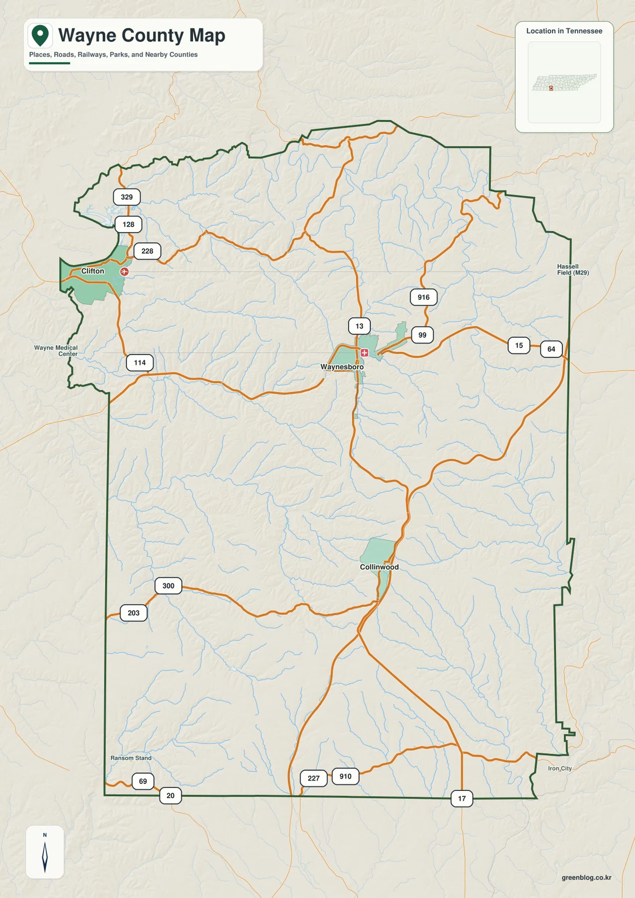
The county borders Perry County to the north and reaches toward Lewis and Lawrence counties on the east. Hardin and Decatur counties provide western references, and the southern county line meets Alabama. Outside labels such as Iron City and Ransom Stand help with orientation near the edge, but the green county boundary should be used to distinguish nearby places from features actually inside Wayne County.
The city map uses Clifton as the hub instead of the county seat
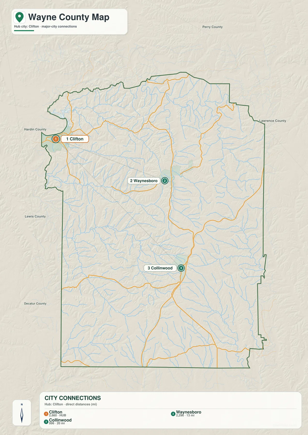
The supplied city-connections map is centered on Clifton rather than Waynesboro. It labels Clifton at 2,660, Waynesboro at 2,296, and Collinwood at 996. From the Clifton hub, Waynesboro is shown about 13 miles away by direct distance and Collinwood about 20 miles away. These figures belong to the supplied city graphic and are intended for relative comparison, not as driving distances or a current official population table.
That hub choice makes the west-to-interior relationship easy to see. Clifton sits at the far western side, Waynesboro is much farther into the county, and Collinwood extends the pattern southward. The long connector lines underline how widely separated the main settlement labels are. The Tennessee River setting also gives Clifton a geographic role that differs from Waynesboro’s administrative position.
Countywide figures provide a different scale. The existing source material lists 16,232 residents in the 2020 census and a July 2025 estimate of 16,416. Wayne County contains about 734.1 square miles of land and 1.6 square miles of water. Dividing the 2020 count by the land area gives roughly 22.1 residents per square mile, which is consistent with the wide spacing of the principal settlement labels and the large amount of rural terrain shown on the maps.
Tennessee River on the west, Buffalo River in the north, and Green River through the interior
The broadest water feature is the Tennessee River along the western side near Clifton. Large bends sit directly beside or just outside the county boundary, giving the western edge a shape very different from the interior. Even though the countywide water area is relatively small, the river matters strongly for orientation because crossings and shoreline access occur only at particular places.
Buffalo River is labeled across the northern part of the water map, while Green River follows a long north-to-south valley through the interior. Beech Creek and Eagle Creek are prominent in the northwest, and Hardin Creek extends through the western interior. Farther east, Rainbow Lake and Fortyeight Creek provide useful local reference points. The southern half contains Indian Creek, Weatherford Creek, Cypress Creek, Little Cypress Creek, and a dense network of smaller branches.
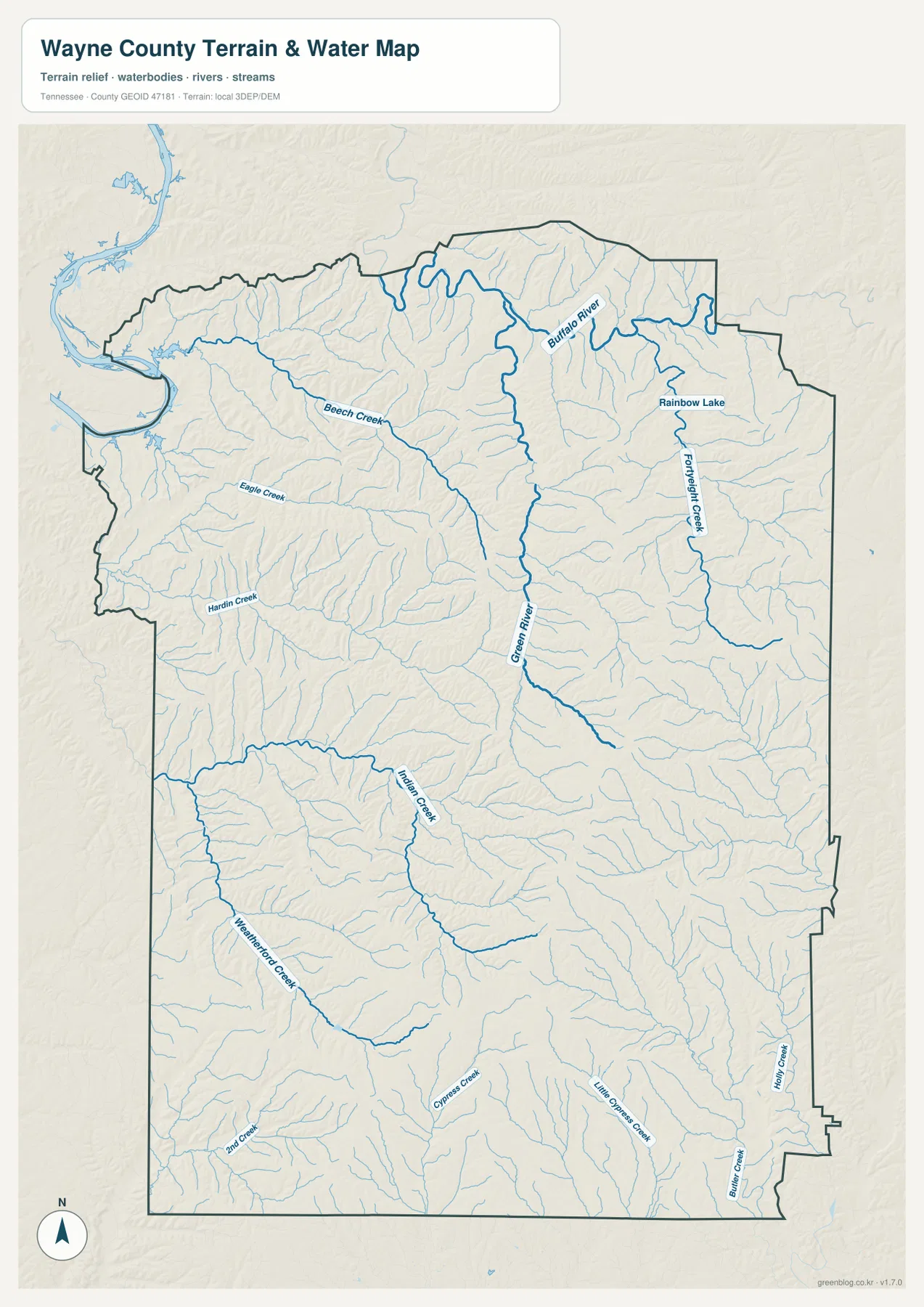
Holly Creek and Butler Creek appear near the southeastern boundary, adding to the dense drainage pattern. The large number of narrow channels is an important clue to the terrain: Wayne County is divided by many small valleys rather than being one broad flat surface. This map is a static geographic reference and does not provide current river stage, flood limits, boating depth, navigation status, or legal parcel boundaries.
Elevation rises from a low western river corridor into higher interior and eastern hills
The elevation map gives Wayne County an actual range of about 108 to 330 meters and a mean near 241 meters. The darkest green terrain is concentrated along the Tennessee River side and in the lower western valleys. Moving eastward, the surface becomes increasingly textured, with yellow and brown ridges separated by narrow green stream corridors.
Much of the central-eastern county lies above the western river lowlands, and broad areas of the east contain terrain in the upper portion of the mapped range. Green River and the creek network cut lower valleys through these hills. The southern half also contains a repeated pattern of ridges and stream corridors, so the route from the Waynesboro area toward Collinwood crosses a landscape that is far more varied than a flat political map suggests.
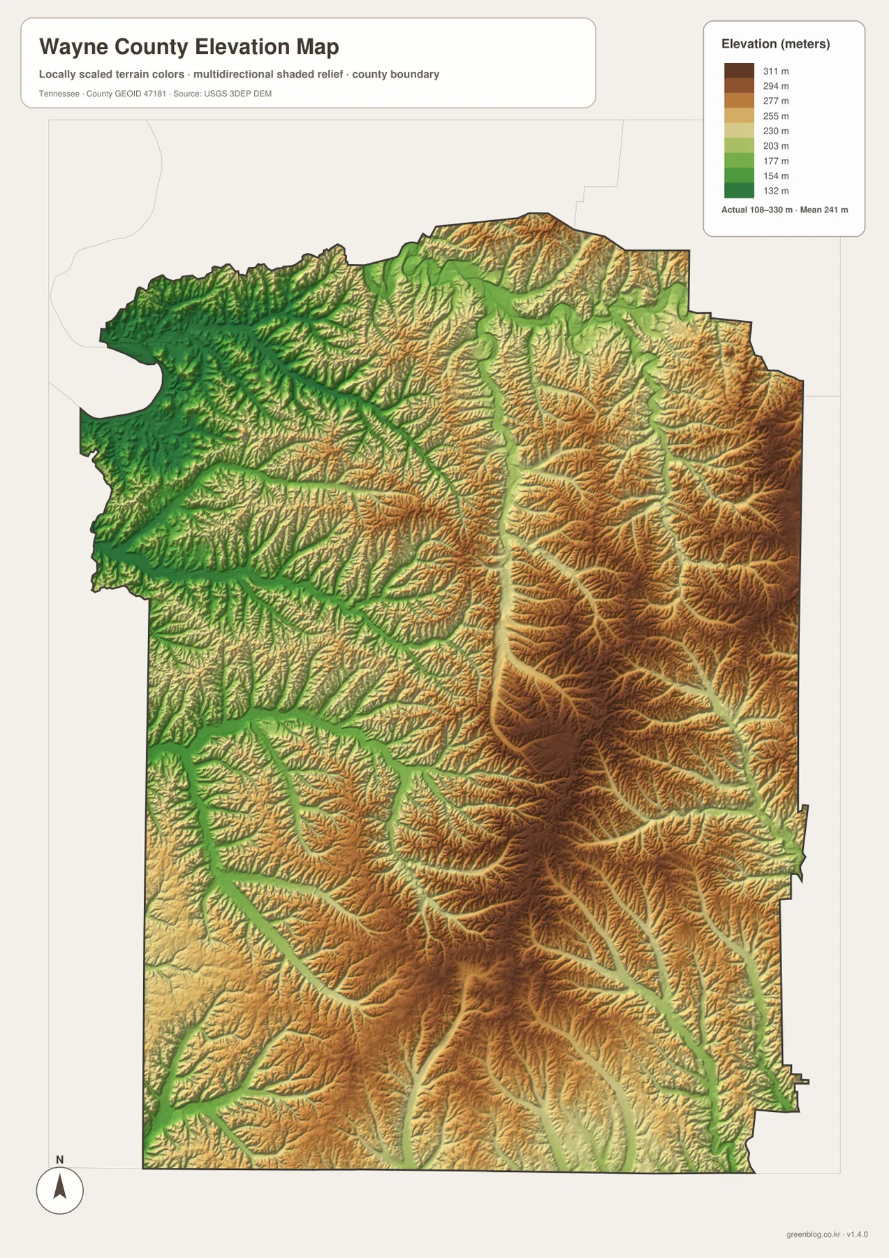
The supplied reference material identifies the Highland Rim as an important regional terrain setting. The elevation map adds county-level detail by showing how strongly the western river lowlands differ from the interior hills. It is useful for broad comparison, but the colored surface is not survey-grade elevation and should not be used for a parcel height, road grade, construction plan, or engineering decision.
Why the county’s main routes repeatedly follow lower valleys
The relationship between roads and relief is especially clear around Waynesboro. Route 13 provides a strong north-south line, but roads leaving the center bend as they encounter stream valleys and closely spaced ridges. Green River and its tributaries create lower passages through the interior, and several roads make use of those corridors rather than crossing every ridge directly.
The western side presents a different limitation. Ground near Clifton is lower, but the Tennessee River itself restricts where direct crossings and approaches can occur. Toward Collinwood, the main routes must pass through a long landscape of creeks and hills. That is why the direct-distance lines on the city map should be read as simple comparisons rather than predictions of actual travel distance.
Wayne County was established in 1817, and Waynesboro is the county seat in the supplied reference material. The current map reinforces that role because Waynesboro is also the strongest interior road junction. Clifton and Collinwood serve different geographic purposes: one anchors the river side, and the other provides a southern reference in a county whose principal settlements are widely separated.
Choosing the Wayne County map that best fits the task
Use the general county map when you need Waynesboro, Clifton, Collinwood, principal roads, and the boundary in one view. The city map is the fastest way to compare the three settlement anchors and the direct distances from Clifton. The water map is better for Tennessee River, Buffalo River, Green River, and named creeks, while the elevation map shows the contrast between the low west and the higher interior.
For printed study or annotation, one copy can focus on Waynesboro and the major road network, with Clifton and Collinwood added as outer anchors. A second copy can emphasize the Tennessee River, Buffalo River, Green River, the western lowlands, and the higher central-eastern hills. Separating transportation from physical geography keeps the map readable and makes the relationship between route choice and terrain easier to see.
When comparing Wayne County with neighboring areas, begin with the county outline, then add the three main settlement labels before tracing roads and streams to the border. This sequence keeps nearby outside places from being confused with locations inside the county and makes it easier to follow which routes continue toward Perry, Lewis, Lawrence, Hardin, Decatur, or Alabama.
Frequently Asked Questions
How far are Waynesboro and Collinwood from Clifton on the city map?
The supplied city-connections map shows Waynesboro about 13 miles from Clifton and Collinwood about 20 miles away by direct distance. These are straight-line comparisons, not driving distances. Roads must follow the available crossings, valleys, and hill corridors, so an actual trip can be longer.
Which waterways are easiest to identify on the Wayne County water map?
The Tennessee River is the broadest water feature along the western side near Clifton. Buffalo River crosses the north and Green River runs through the interior, while Beech Creek, Fortyeight Creek, Indian Creek, Weatherford Creek, and other tributaries trace smaller valleys. Current flood or river conditions require live official information.
What does the elevation map show about the western side of the county?
The western Tennessee River side contains much of the lowest terrain. The supplied elevation map ranges from about 108 to 330 meters, with a mean near 241 meters, and the interior and east generally rise into more closely dissected hills. Parcel-level elevation requires more detailed source data.
Map File Information
The ZIP contains the high-resolution JPG originals for the Wayne County map, city map, water map, and elevation map shown on this page. The four A3-format images are better suited to printing, enlarged viewing, and annotation than the WebP previews in the article.
- Included Files: County map, city map, water map, and elevation map
- File Type: ZIP containing 4 JPG images
Related Maps
- Alamo to Gadsden: A Crockett County Tennessee Map
- Altamont, Monteagle, and Plateau Valleys — Grundy County Tennessee Map
- Around Chattanooga: Hamilton County Tennessee Map
Sources and References
- Tennessee State Library and Archives Wayne County fact sheet
- Tennessee Department of Transportation Wayne County map
- U.S. Census Bureau Wayne County QuickFacts
- USGS National Hydrography
- USGS 3D Elevation Program
Green Map creates custom-edited map images using open geographic data sources such as geoBoundaries, Natural Earth, OpenStreetMap, and government open data. These maps are edited visual materials, not raw data files, and are provided for education, documents, presentations, and graphic reference.