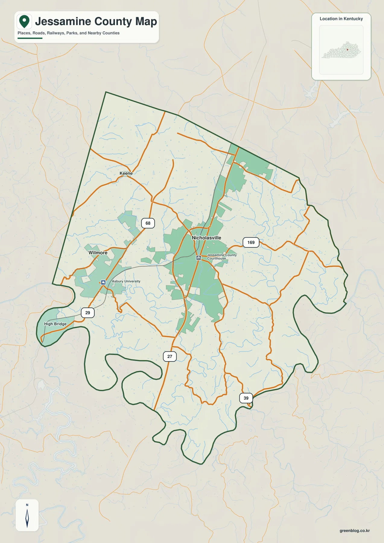
Jessamine County lies immediately south of Lexington and is organized around Nicholasville, with Wilmore and Keene providing smaller reference points to the west. U.S. 27 is the most prominent north-south route on the county map, while routes 68, 29, 39, and 169 branch toward rural areas, river bends, and neighboring communities. The four supplied map files separate roads, city locations, waterways, and elevation so each layer can be read without crowding everything onto one page.
High-resolution JPG versions are available together in the download ZIP near the end of this page. The web images are useful for quick viewing, but the JPG originals are better when road numbers, creek labels, or the sharp bends of the Kentucky River need to be enlarged or printed.
Table of Contents
Nicholasville anchors the road network between Lexington and the Kentucky River
Nicholasville is the clearest starting point on the general county map. It sits a little north of the county’s midpoint, and U.S. 27 passes directly through the city before continuing south. Route 169 crosses the Nicholasville area from west to east, while Route 68 reaches across the northwestern part of the county. Route 39 extends into the southeast, where the road pattern becomes less regular as valleys and ridges become more pronounced.
Wilmore and Keene give the western side two additional anchors. Wilmore appears southwest of Nicholasville with Asbury University marked nearby, making the town easy to identify. Keene sits farther northwest near Route 68. High Bridge appears close to the deeply curved Kentucky River boundary in the southwest, where the county outline becomes much more irregular than it is near Nicholasville.
The southern boundary is shaped by a landscape of river bends and narrow valleys rather than by one simple line. That distinction matters when reading the road network: the north and center contain broader uplands with more direct connections, while the roads approaching the Kentucky River frequently follow the contours of valleys and ridges. The map therefore shows both an accessible central corridor and a much more dissected southern edge.
Three city markers show a compact Nicholasville–Wilmore–Keene relationship
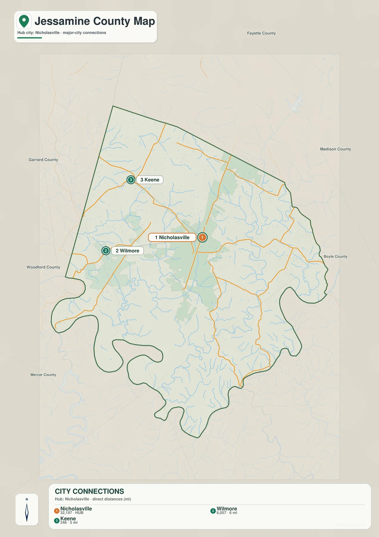
The city-connections map strips away much of the road detail and emphasizes Nicholasville, Wilmore, and Keene. The map prints reference values of 32,197 for Nicholasville, 6,057 for Wilmore, and 346 for Keene. Those numbers are best treated as values embedded in this map rather than as replacements for current Census estimates; their practical role here is to show the large difference between the county’s primary city and its smaller western communities.
Using Nicholasville as the hub, the map gives a straight-line distance of about 6 miles to Wilmore and about 5 miles to Keene. Straight-line distance is not driving distance, but it is useful for quickly comparing direction and separation. Wilmore lies to the southwest and Keene to the northwest, so the three markers create a simple frame for the more detailed road pattern visible on the county map.
This simplified city view is especially useful because Jessamine County sits beside the much larger Lexington urban area. The county map contains many roads and developed areas near the north, but the city layer keeps attention on the named places within the county. When combined with the road map, it becomes easier to see why Nicholasville functions as the main local center while Wilmore and Keene occupy distinct positions to the west.
Kentucky River bends frame a dense network of Hickman and Jessamine creeks
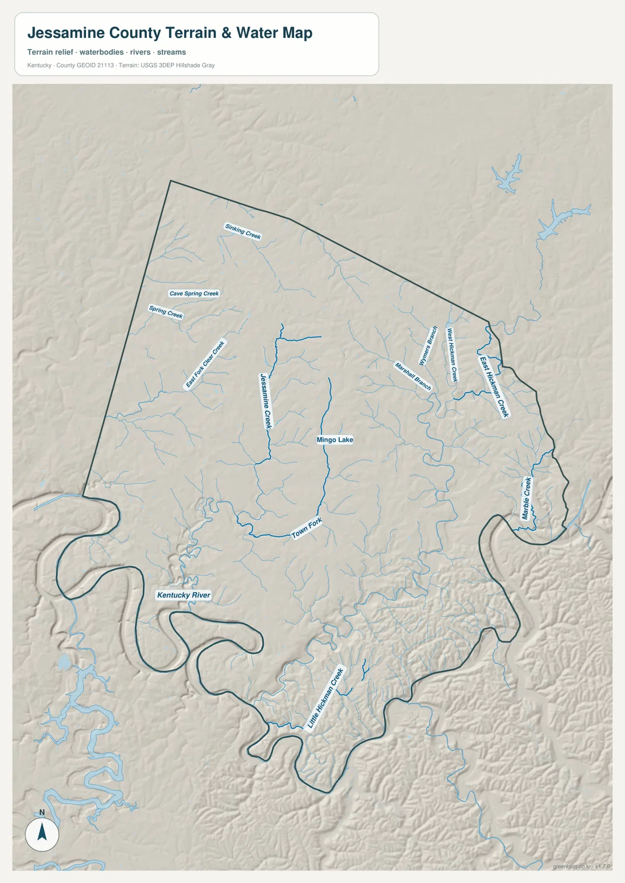
The terrain-and-water map is dominated by the Kentucky River along the southern and southwestern edge. Its broad bends cut into steep terrain and create a very different landscape from the gentler uplands around Nicholasville. Jessamine Creek runs through the central-western part of the county, and Town Fork forms another prominent watercourse farther south. Smaller tributaries branch into both systems.
East Hickman Creek and West Hickman Creek are labeled on the eastern side, accompanied by Williams Branch and Marshall Branch. Marble Creek appears near the southeastern boundary, while Little Hickman Creek cuts through the deeply dissected southern terrain. In the northwest, Shining Creek, Cave Spring Creek, Spring Creek, and East Fork Clear Creek add another cluster of named streams. Mingo Lake is also labeled near the central-eastern part of the county.
These waterways explain much of the county’s visible relief. The Kentucky River occupies the deepest regional valley, and many smaller creeks follow narrow low corridors that extend back into the uplands. The water map is intended for general geographic reference, not flood-zone decisions, parcel boundaries, navigation, or current stream conditions. Those uses require current agency data and purpose-specific mapping.
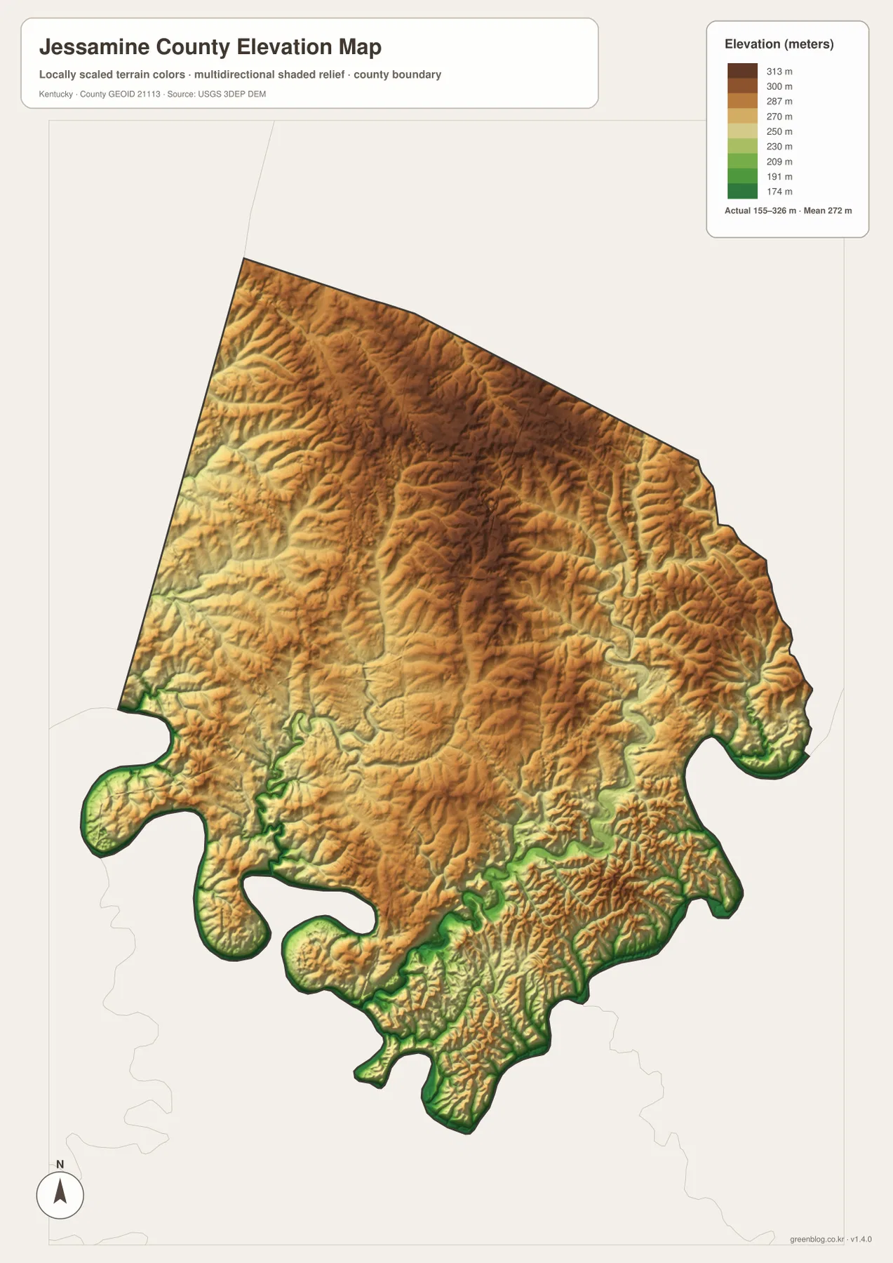
Elevation ranges from about 155 to 326 meters across uplands and river gorges
The elevation map reports an actual range of about 155 to 326 meters and a mean of 272 meters. Broad areas across the northern and north-central county are colored brown and tan, indicating relatively high uplands. The lowest green terrain follows the Kentucky River and the narrow valleys that cut into the southern and southwestern boundary.
The eastern side contains another important contrast. East Hickman Creek and Marble Creek occupy low, sinuous corridors, while short ridges rise closely around them. Similar patterns appear around Little Hickman Creek in the south. When the elevation and water maps are compared, the relationship is direct: named streams tend to occupy green lowlands, and the terrain rises quickly between adjacent valleys.
A mean of 272 meters does not imply that Jessamine County is uniformly high. The northern uplands and southern river gorges are separated by substantial local relief, and the terrain becomes increasingly dissected near the Kentucky River. This generalized elevation surface is appropriate for county-scale comparison, not for surveying, construction design, engineering calculations, or exact parcel elevations.
Camp Nelson connects U.S. 27 with a nationally significant historic landscape
Camp Nelson National Monument adds an important historical layer to the county’s geography. The National Park Service places the monument along U.S. 27 south of Nicholasville and explains that the site began as a Union Army supply depot in 1863. It later became a major recruitment and training center for United States Colored Troops and a refuge for civilians and people escaping slavery. Its location along the same north-south corridor that dominates the road map gives modern visitors a clear way to connect the county’s transportation geography with its Civil War history.
Wilmore offers a different local reference. Asbury University is marked beside the town on the general map, while High Bridge appears farther southwest near the Kentucky River. Those labels make it possible to move from the county’s settled uplands to the river gorge without relying on unnamed points. Together, Nicholasville, Wilmore, Camp Nelson, and High Bridge provide a practical set of landmarks for understanding how the county’s communities relate to its steep southern terrain.
For current local information, Jessamine County Government and the City of Nicholasville maintain official websites covering county and municipal services. Travelers should check those sources for changing road, facility, or event information rather than treating a static map as a live conditions source.
Use the high-resolution files for printing and side-by-side comparison
The general county map is the best starting point for roads, boundaries, and named places. It keeps Nicholasville, Wilmore, Keene, High Bridge, U.S. 27, and the main numbered routes on one page. The city map is cleaner when the question is simply how Nicholasville, Wilmore, and Keene relate to one another and how far the two smaller places lie from the hub by straight-line distance.
For waterways, the terrain-and-water map provides the clearest labels for the Kentucky River, Jessamine Creek, East and West Hickman Creek, Marble Creek, Little Hickman Creek, and smaller tributaries. Pairing it with the elevation map shows where those streams occupy lower corridors and where uplands rise around them. The two files work well together for classroom geography, county overviews, and general landscape study.
The WebP images on this page are optimized for quick viewing. The downloadable ZIP contains four high-resolution JPG originals, which are better for enlarging small labels, printing a wall or classroom sheet, or comparing the same location across different map layers. They remain general-reference maps and do not replace survey, flood, engineering, or real-time transportation products.
Frequently Asked Questions
What is the easiest place to use as an orientation point in Jessamine County?
Nicholasville is the clearest starting point because it is the county’s main city marker and U.S. 27 passes directly through it. From Nicholasville, Wilmore lies to the southwest and Keene to the northwest, while the Kentucky River bends occupy the southern edge of the county.
Which map best shows the Kentucky River and Hickman Creek branches?
The terrain-and-water map is the best choice. It labels the Kentucky River, Jessamine Creek, East Hickman Creek, West Hickman Creek, Marble Creek, Little Hickman Creek, and several smaller branches. Comparing it with the elevation map also shows how those waterways follow the county’s lower valleys.
Can the elevation map be used for surveying or construction?
No. The map provides a county-scale view with an actual range of about 155–326 meters and a mean of 272 meters. Exact site elevations, engineering design, construction, flood analysis, and property surveys require original data or professional measurements.
Map File Information
Download the Jessamine County general, city, terrain-and-water, and elevation maps as high-resolution JPG originals.
- Included Files: county map, city map, terrain-and-water map, elevation map
Related Maps
Sources and References
Local information is available from Jessamine County Government and the City of Nicholasville. Historical context for Camp Nelson comes from the National Park Service. Boundary and road references are supported by U.S. Census Bureau TIGER/Line, water features by USGS National Hydrography, and elevation data by the USGS 3D Elevation Program.
Green Map creates custom-edited map images using open geographic data sources such as geoBoundaries, Natural Earth, OpenStreetMap, and government open data. These maps are edited visual materials, not raw data files, and are provided for education, documents, presentations, and graphic reference.