Download the original high-resolution A3 JPG map files for St. Francis County from the ZIP on this page. Use the Download Map Files button near the end of the article to get the county reference map, city map, terrain-and-water map, and elevation map together. The maps focus on the county’s clearest geographic contrast: Crowley’s Ridge rises through the middle of the low Arkansas Delta, Forrest City sits on its western slope, and broad river lowlands extend on both sides.
The county is easier to understand when those features are connected rather than viewed separately. Interstate 40 passes through Forrest City and continues across the Delta, Highway 1 runs north toward Caldwell and Colt, the L’Anguille River occupies the lowland west of the ridge, and the St. Francis River winds through the flat country to the east. The sections below use those relationships to explain where the main towns, roads, waterways, and elevation changes appear.
Table of Contents
Crowley’s Ridge is the feature that organizes the whole county
The elevation image makes St. Francis County look unlike many other Delta counties. Most of the map is low green terrain, but a narrow brown and tan band runs north to south through the center. That band is Crowley’s Ridge. The supplied map gives an actual county elevation range of roughly 50 to 137 meters, with a mean near 66 meters, so the ridge is not high in a mountain sense. It stands out because the surrounding plains are so low and flat.
Forrest City lies on the western slope of this higher ground. East of the city, the land drops toward Madison, Widener, and the St. Francis River plain. West toward Palestine and Wheatley, the terrain also falls into lower country associated with the L’Anguille River. That position makes Forrest City an especially useful anchor: it connects the county seat, the main highway corridor, and the sharpest terrain transition on the map.
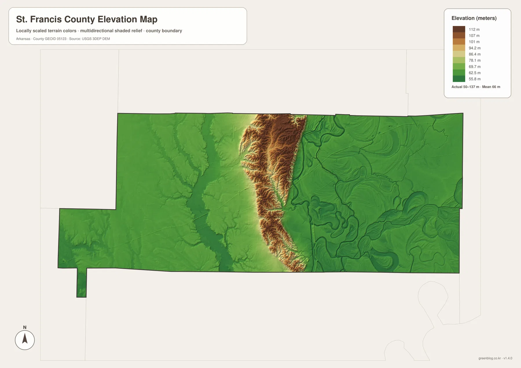
The ridge is long but relatively narrow. On the elevation map, colors change quickly as you move away from it, especially toward the broad eastern plain. Comparing this image with the water map explains another important point: the major rivers follow the lower land beside the ridge rather than the ridge itself. The elevation view is useful for county-scale relief, but it should not be treated as survey or engineering data for a specific parcel, road project, or construction site.
Forrest City and Interstate 40 provide the simplest way to get oriented
Forrest City is the county seat and the largest place shown on the reference map. Interstate 40 crosses the county through the Forrest City corridor, and Highway 1 heads north from the same area toward Caldwell and Colt. Those two routes establish the basic east–west and north–south directions without requiring the reader to follow every smaller highway number.
West of Forrest City, Palestine lies close to Interstate 40, with Goodwin and Wheatley farther toward the southwest. East of the county seat, Madison and Widener sit along the broader cross-county corridor. Hughes occupies a very different position near the southeastern end, close to Routes 149 and 38. The gaps between these communities show that St. Francis County is not one continuous built-up area; much of the space between towns is rural Delta land.
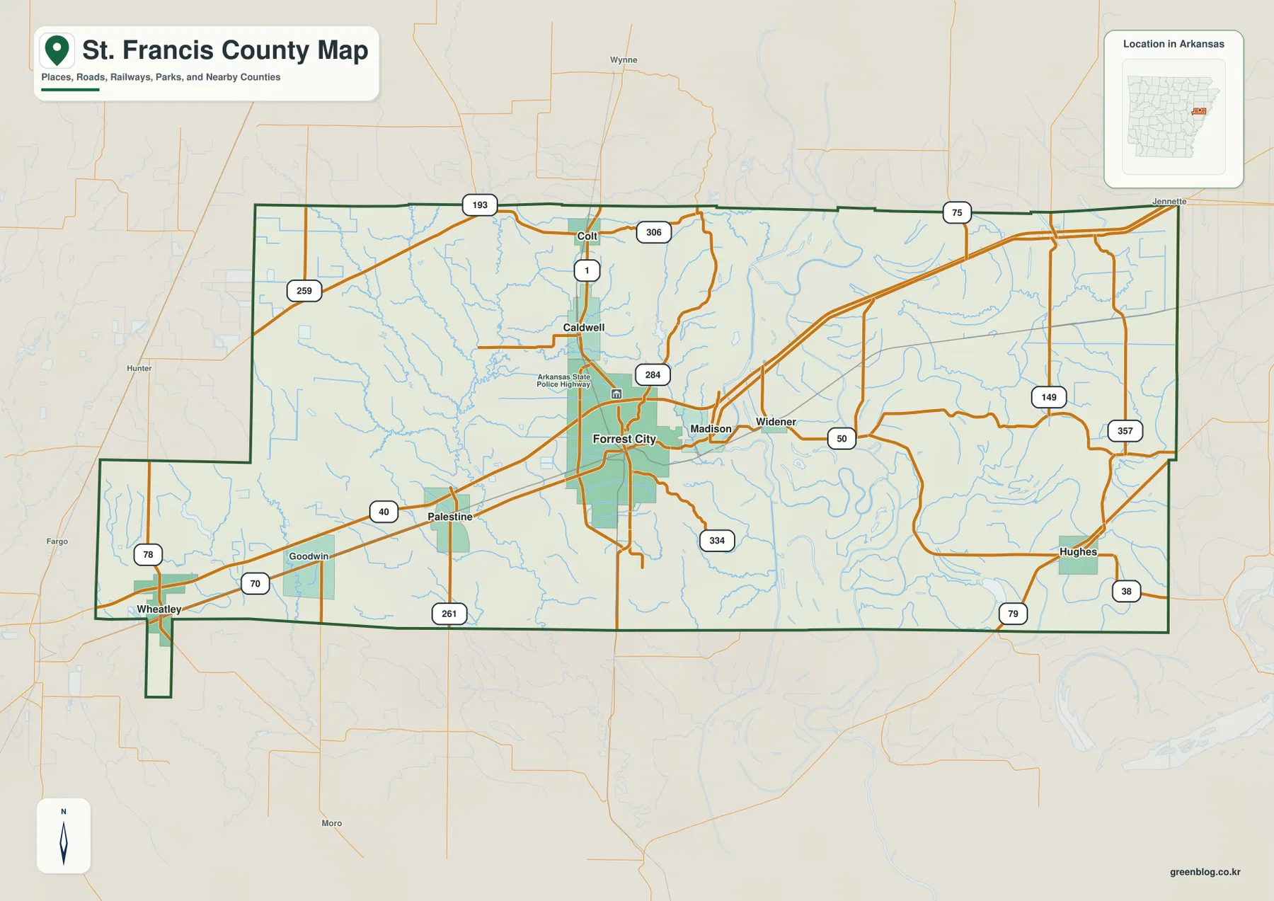
The southwestern boundary deserves a quick look because it is not a simple straight edge. Near Wheatley, the county outline steps inward and includes a narrow southward section. Cross County lies to the north, Crittenden County is to the east, and Lee and Woodruff counties appear along the western side in the supplied map context. Following the heavy county outline is the safest way to decide whether a nearby road or place label is inside St. Francis County.
The city map emphasizes distance and direction more than road detail
The simplified city view ranks Forrest City first and also labels Hughes, Palestine, Colt, Madison, and Caldwell. The ranking is useful, but the geography is more informative. Caldwell and Colt form a close northern pair above Forrest City, Palestine sits west of the county seat, Madison lies to the east, and Hughes is separated from the main group in the southeast.
That spacing mirrors the broader county landscape. Roads and services are most concentrated near Forrest City, while the towns farther east and southeast are surrounded by wider stretches of low rural ground and watercourses. The city image therefore works best as a quick orientation tool. Readers who need smaller communities, individual highways, or county-edge detail should return to the full reference map.
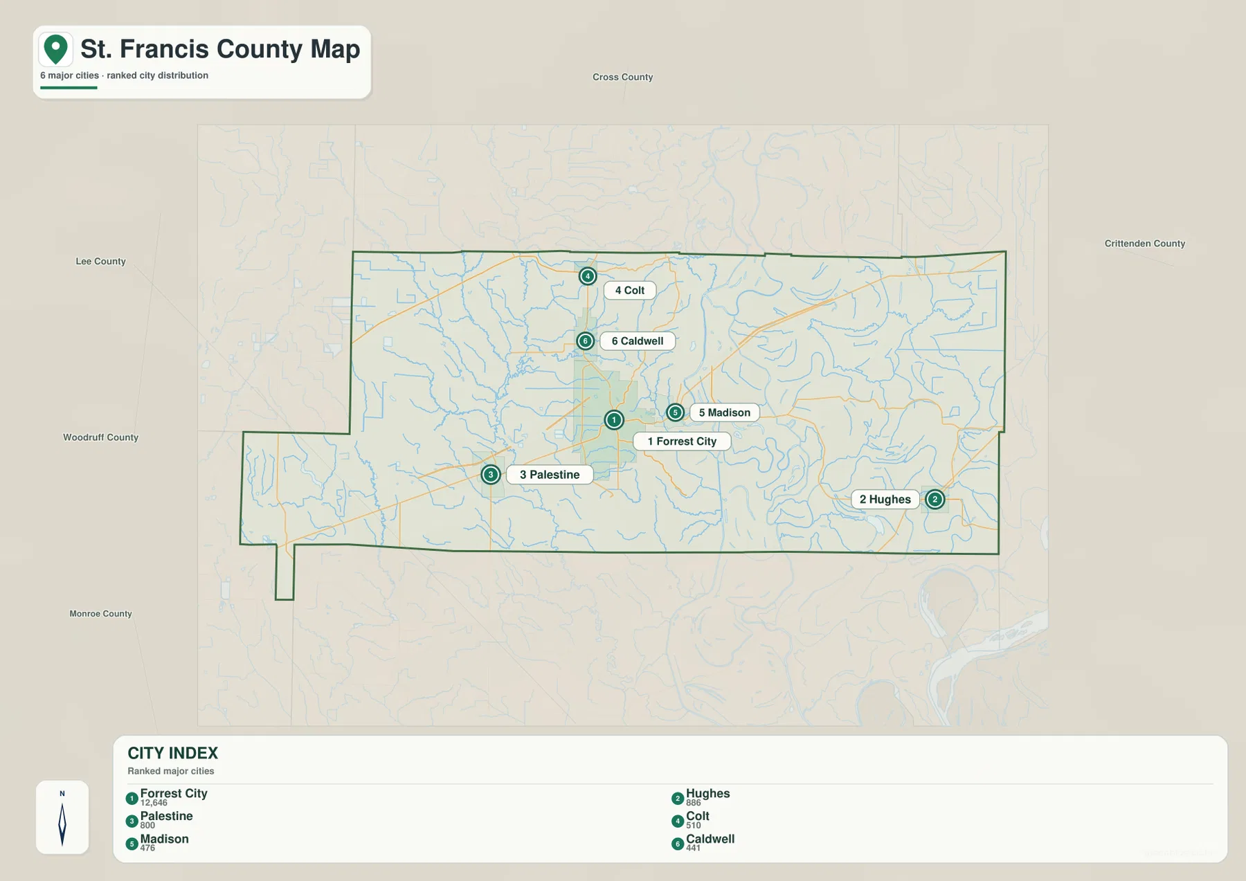
The population values printed on the supplied city graphic are comparison figures within that image. They are not a substitute for the latest Census estimate. For current population or demographic data, use an official statistical source. Here, the city map is most valuable for seeing relative placement and the uneven spacing of the county’s main communities.
The two major river lowlands sit on opposite sides of the ridge
The terrain-and-water view completes the physical picture. West of Crowley’s Ridge, the L’Anguille River runs through low country and receives smaller channels such as Second Creek and Big Creek. East of the ridge, the St. Francis River follows a much more sinuous course across the flat Delta. The two rivers are separated by the county’s narrow high ground, so the water map and elevation map reinforce each other particularly well.
The eastern lowland contains a remarkable collection of curved water features. Horseshoe Lake, Lake St Francis, Round Pond Cutoff, Long Lake, Old River, and Mud Lake appear around the St. Francis River system. Blackfish Bayou crosses the northeastern side toward Blackfish Lake. Many of these shapes look very different from the straighter road network because they preserve bends and abandoned channels associated with the river plain.
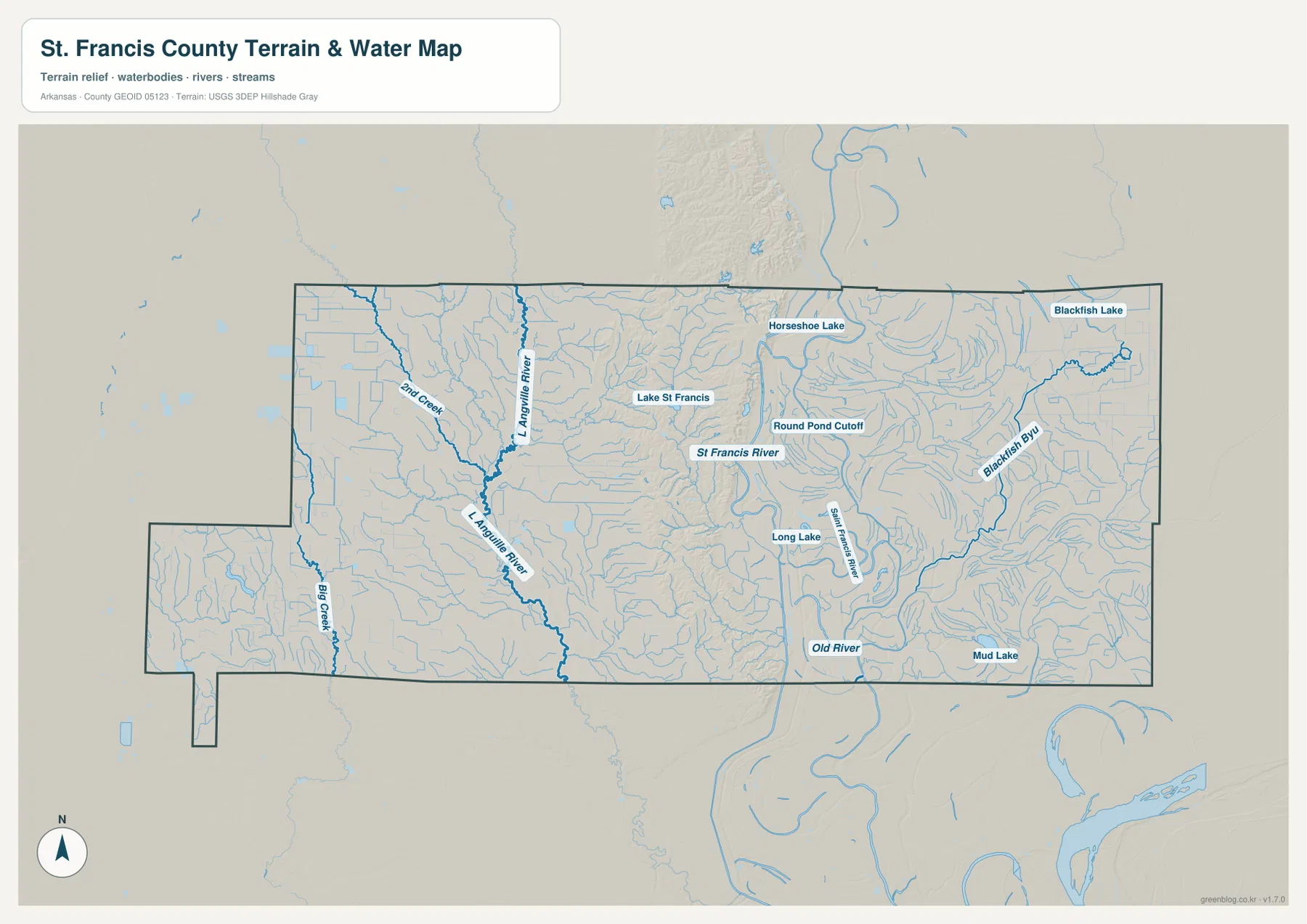
Madison sits close to the western side of the St. Francis River system, while Hughes lies farther southeast among a denser network of channels. Palestine and Wheatley are on the opposite side of the ridge, closer to the L’Anguille drainage. Comparing town positions with the water features makes the east–west split much clearer than looking at road labels alone.
This water image is intended for geographic reference. It is not a flood-hazard map, parcel survey, water-quality report, or navigation chart. Anyone making a safety, property, or engineering decision should use the responsible agency’s current specialized data rather than a county-scale reference map.
Use the map that matches the question you are trying to answer
For basic orientation, begin with the county reference map because it combines towns, roads, waterways, and the boundary in one view. The city map is cleaner when the goal is to compare the principal communities without extra detail. The terrain-and-water image is the better choice for the two rivers, bayous, lakes, and old channels. The elevation map is the clearest way to explain why Crowley’s Ridge stands out inside the low Delta.
Two maps together often tell the story more clearly. A lesson about Forrest City can pair the road map with the elevation image to show why the city sits at the edge of the ridge. A discussion of Madison or Hughes can combine the reference and water maps to show how those towns relate to the St. Francis River system. For a county-wide overview, placing the elevation and water views side by side reveals the ridge-and-lowland structure immediately.
The downloadable originals are 3638 × 2572-pixel JPG files suited to A3 landscape printing, zooming into labels, or inserting into a document. Keep the original aspect ratio when resizing so roads, rivers, and the county boundary do not become distorted. If several copies are needed, a single test print is useful for checking printer margins and label size before printing the full set.
Frequently Asked Questions
Why is Forrest City a useful starting point on a St. Francis County map?
Forrest City is the county seat, the largest mapped city, and a major road center where Interstate 40 and Highway 1 meet. It also sits on the western slope of Crowley’s Ridge, so one location connects the county’s human geography with its most distinctive landform.
What is the narrow high strip through the middle of the elevation map?
It is Crowley’s Ridge. The supplied map shows the ridge as a narrow band of higher terrain rising above the much lower Delta plain. The county-wide elevation range is about 50 to 137 meters.
How are the L’Anguille and St. Francis rivers positioned?
The L’Anguille River occupies the lowland west of Crowley’s Ridge, while the St. Francis River winds across the broad low plain to the east. Finding the ridge between the two rivers is the simplest way to understand the county’s physical layout.
Map File Information
The ZIP contains the original St. Francis County reference, city, terrain-and-water, and elevation maps as high-resolution JPG files.
- Included Files: County reference map, city map, terrain-and-water map, elevation map
- Printable Size: 3638 × 2572 pixels each
- File Type: Four high-resolution JPG files in one ZIP archive
Related Maps
Sources and References
- St. Francis County, Arkansas – Official Government Website – County offices and public services based in Forrest City.
- Encyclopedia of Arkansas – St. Francis County – County geography and history, including Crowley’s Ridge and the two major river lowlands.
- Encyclopedia of Arkansas – Forrest City – Background on the county seat and its location on the ridge.
- USGS National Hydrography – Official information about U.S. rivers, streams, lakes, and hydrographic data.
- USGS 3D Elevation Program – Official elevation and terrain data information.
Green Map creates custom-edited map images using open geographic data sources such as geoBoundaries, Natural Earth, OpenStreetMap, and government open data.
These maps are edited visual materials, not raw data files, and are provided for education, documents, presentations, and graphic reference.