Sharp County stretches across the Ozark foothills of northeastern Arkansas, with a compact group of towns in the northwestern part of the county and much more widely spaced communities to the south. Ash Flat is the county seat, but Cherokee Village, Highland, and Hardy sit close together near the Spring River area. Evening Shade lies farther south, and Cave City marks the southern end of the main mapped settlement pattern.
You can download the original high-resolution A3 JPG files from this Sharp County Map set in one ZIP near the bottom of the page. The package includes the county reference map, city map, terrain-and-water map, and elevation map. The first views are useful for towns and roads, while the water and elevation images make the Spring River, Strawberry River, ridges, and lower valleys easier to compare.
Table of Contents
Start with Ash Flat and the close group of northern towns
Ash Flat is the current county seat of Sharp County. The official county government maintains its main offices there, and the Encyclopedia of Arkansas describes Ash Flat as the seat of government for the unified county. On the reference map, Ash Flat sits just southwest of Highland and Cherokee Village, with Hardy a short distance to the northeast along the Spring River corridor.
This northwestern cluster contains the closest concentration of city labels in the county. Cherokee Village and Highland are nearly adjacent, while Hardy occupies the river valley just to the north and east. Williford lies farther east near U.S. 63. Moving south, the towns become more separated: Evening Shade appears in the lower middle of the county, Sidney is farther southwest, and Cave City sits near the southern boundary.
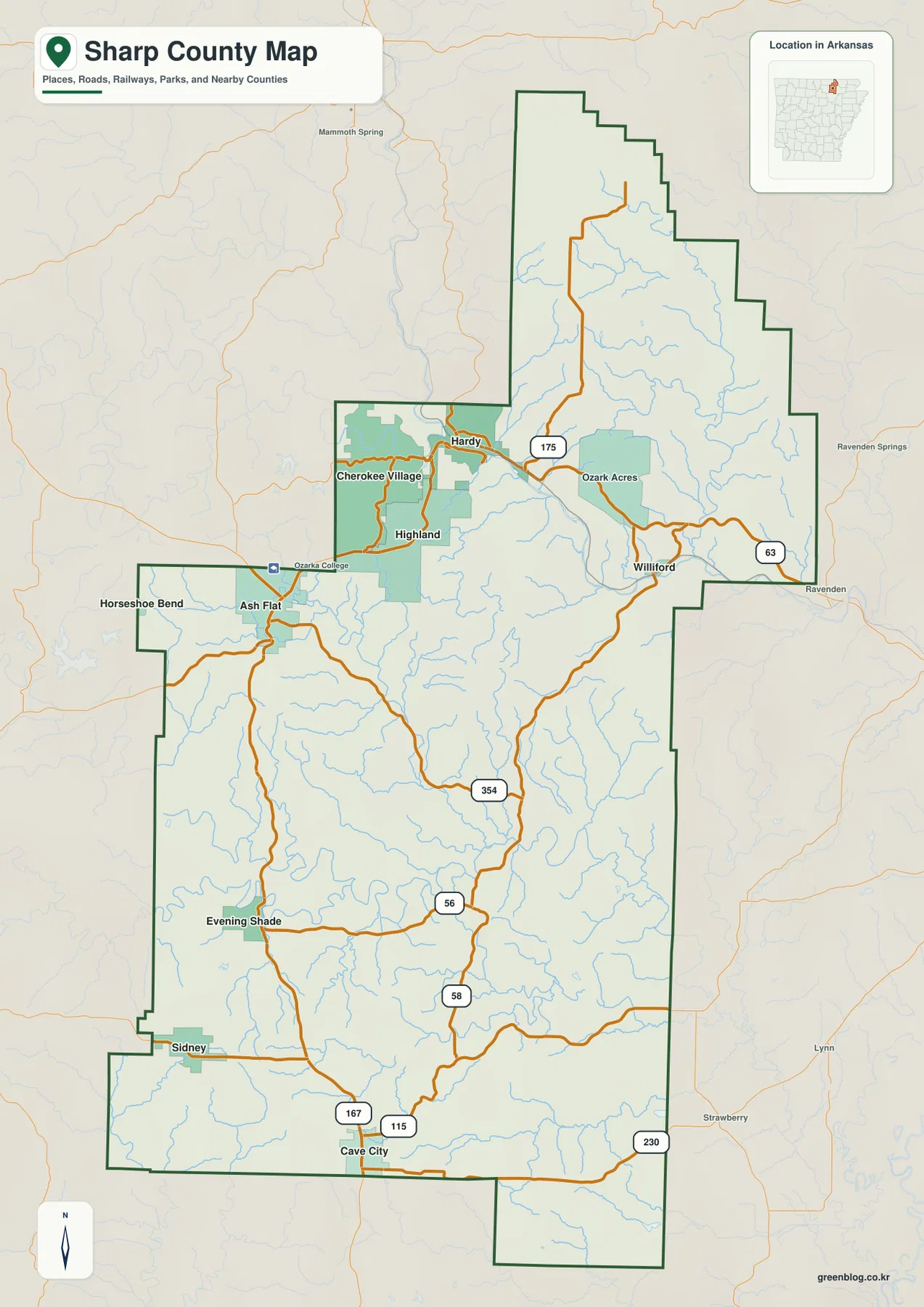
The road network reinforces that north–south contrast. Route 175 and U.S. 63 are visible around Hardy and Williford, while Route 354 crosses the area south of Ash Flat. Around Evening Shade, Routes 56 and 58 provide useful markers. Near Cave City, U.S. 167 and Routes 115 and 230 make the southern junction easy to recognize. Rather than memorizing every road number, locate the town cluster first and use the numbered routes to trace connections from one part of the county to another.
The city map makes the separation between north and south obvious
The ranked city view removes much of the road detail and emphasizes the main population centers. In the supplied graphic, Cherokee Village is listed first, followed by Cave City, Highland, Ash Flat, Hardy, and Evening Shade. The ranking is useful, but the stronger visual story is where those places sit. Four of the six labels are packed into the northwest, while Evening Shade and Cave City are far to the south.
That arrangement helps explain why a single city marker cannot represent the whole county. The Spring River towns form one recognizable cluster, but southern Sharp County has much more open space between settlements. Some places shown on the reference map, including Williford and Sidney, are not part of the six-city ranking. For local orientation, it is helpful to use the simplified city view first and then return to the reference map for the smaller communities and road details.
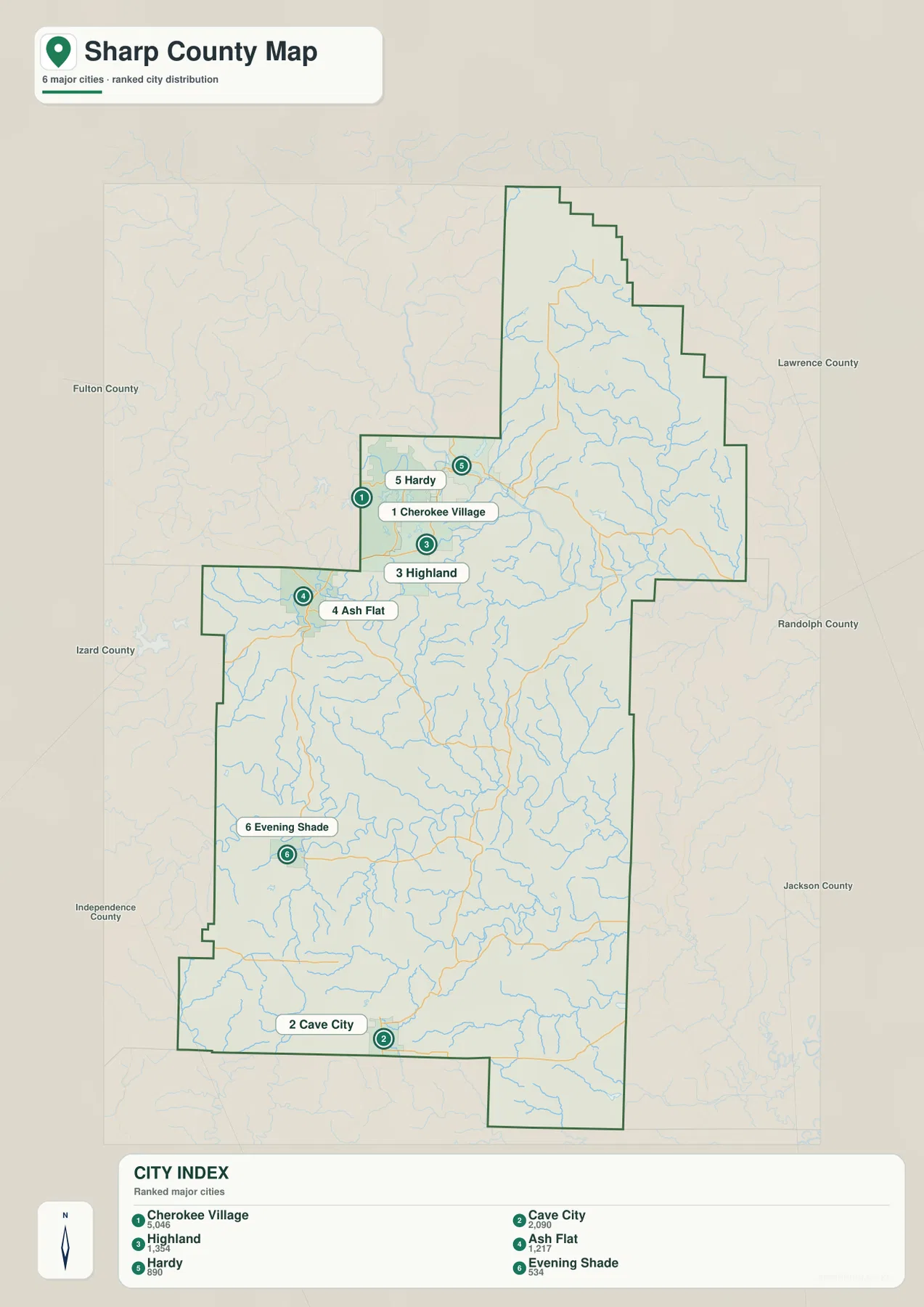
The population numbers printed on the supplied image should be treated as comparison values in the graphic, not as a replacement for a current Census estimate. The main purpose of the city view is geographic: it quickly shows which places are close to one another and how far the southern communities are from the northern cluster. Use an official statistical source if you need current population or demographic figures.
The Spring River ties Hardy to the northern lake district
The Spring River is the clearest water feature in northern Sharp County. It crosses the northwestern section near Hardy before continuing east. The Encyclopedia of Arkansas describes Hardy as a Spring River town and notes that the river is widely used for canoeing, swimming, and fishing. On the map, the river valley also provides a natural line through the same part of the county where several of the major towns are concentrated.
Several named lakes appear close to this river corridor. Lake Sherwood is near the Spring River on the western side of the northern cluster, with Lake Sequoyah, Lake Mirandy, and Wild Plum Lake nearby. Spring Lake and Vagabond Lake appear farther east. Martin’s Creek is the prominent named stream in the northeastern section, flowing through a long valley before reaching lower ground toward the east.
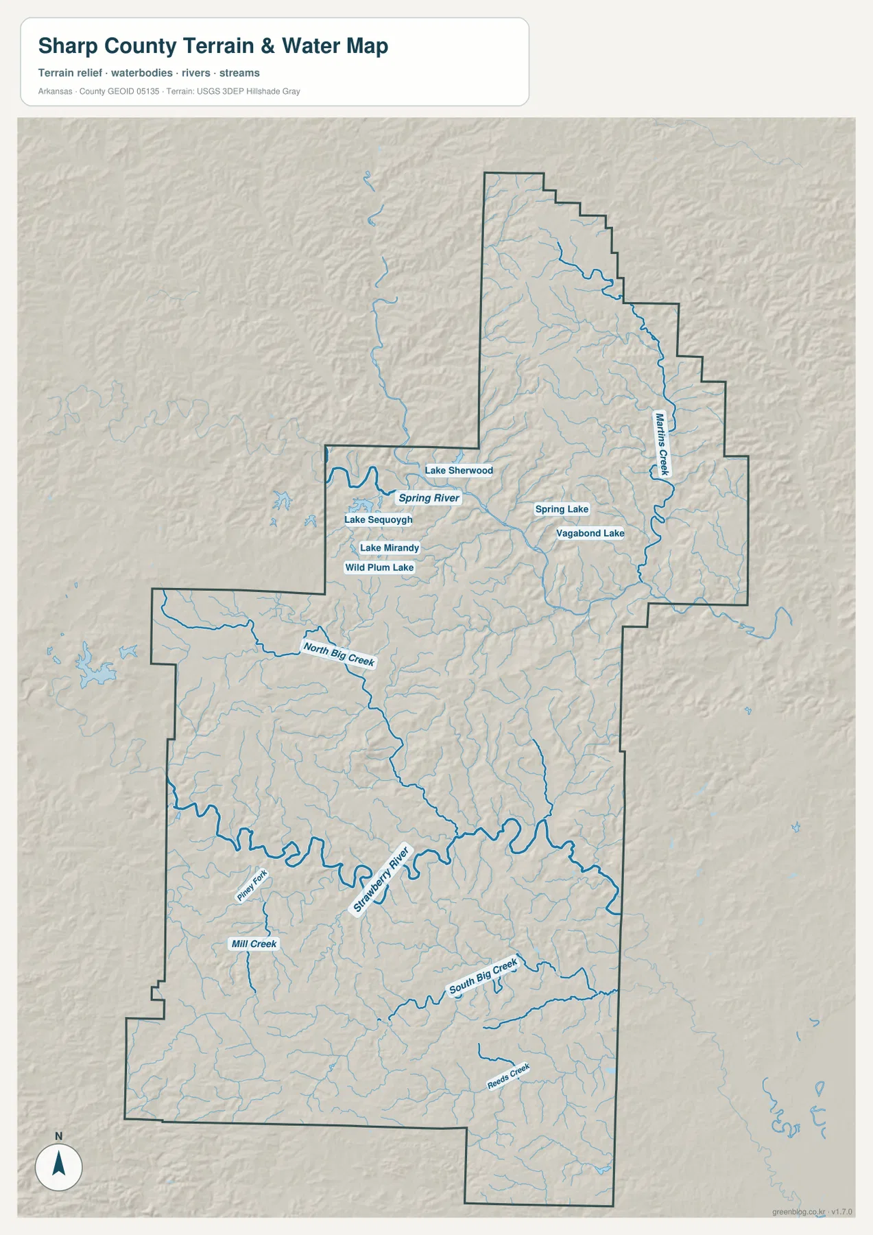
The shaded terrain behind the river makes the setting easier to understand. Higher ground surrounds the Spring River valley, while the river itself occupies a lower corridor cutting across the hills. Hardy and Williford are close to this valley, so pairing the water image with the town map explains their position more clearly than either map can by itself.
The Strawberry River becomes the main water landmark farther south
In the central-southern part of Sharp County, the Strawberry River is the dominant named stream. It makes broad bends across the county and creates a second major valley well south of the Spring River. North Big Creek descends toward this system from the northwest, and Piney Fork and Mill Creek are among the named tributaries on the western side.
South of the Strawberry River, South Big Creek runs across a large part of the lower county, while Reed Creek appears closer to the southern boundary. Many additional small channels are visible even where names are not printed. These tributaries occupy lower ground between the ridges, which becomes especially clear when the water image is compared with the elevation map.
This county-scale water map is intended for geographic reference. It is not a flood-hazard map, property-boundary survey, water-quality report, or navigation guide. When a decision depends on current hazard limits, legal boundaries, or site conditions, use the responsible agency’s current specialized data instead.
Elevation ranges from about 80 to 291 meters across the county
The elevation graphic lists an actual range of about 80 to 291 meters, with a mean near 170 meters. Higher colors appear across much of the northern edge and on several western ridges. Lower green corridors follow the Spring River in the north and the Strawberry River through the middle. The result is a landscape of repeated hills and stream valleys rather than a broad, level plain.
In the north, the Spring River forms a distinct low cut between higher ridges. A similar low corridor follows Martin’s Creek farther east. The Strawberry River produces another broad band of lower elevation in the center, while the western middle portion contains several higher ridge areas. Toward the southeast, the terrain generally becomes lower and less strongly elevated than the northern and western high ground.
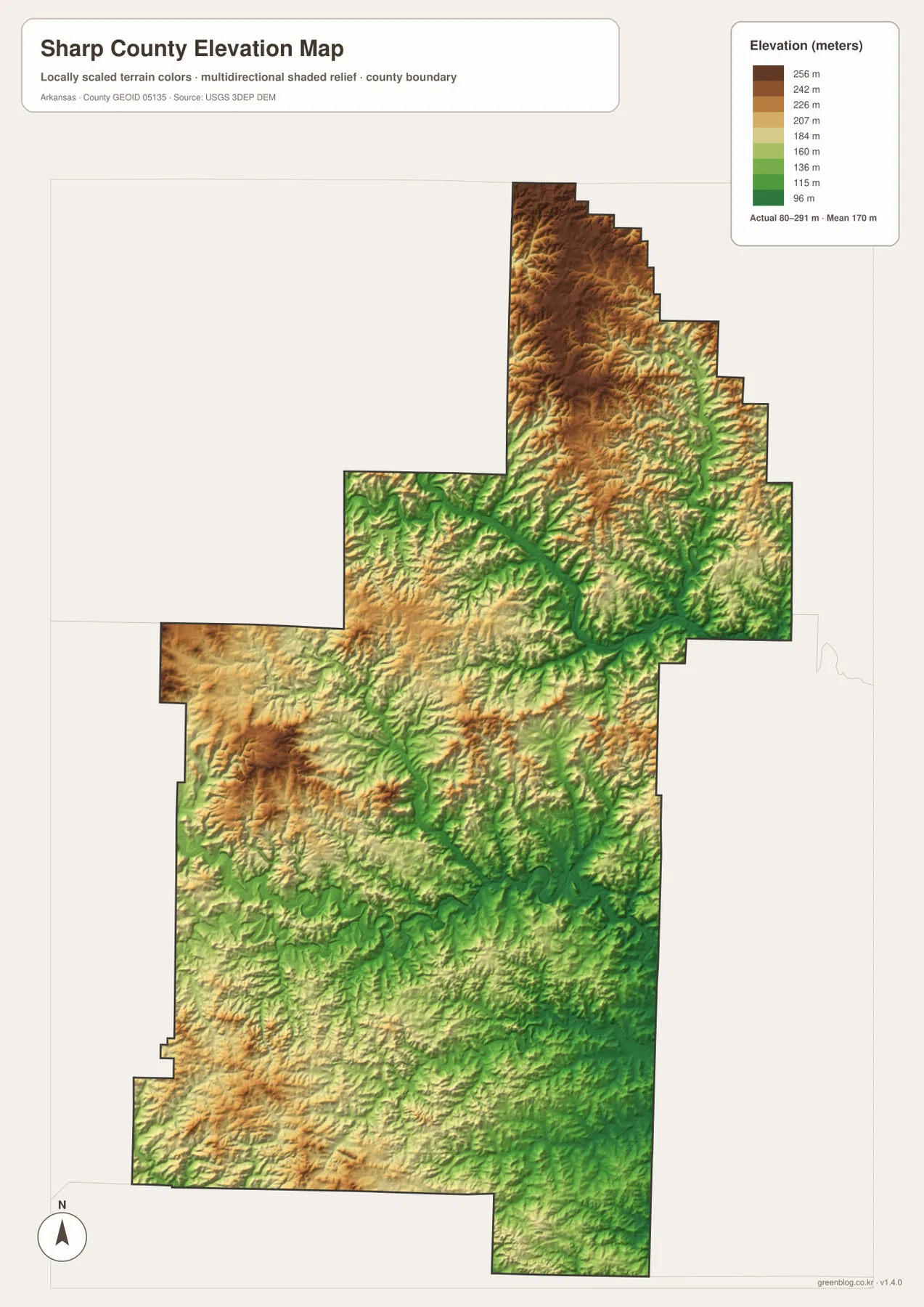
This elevation view is most useful for comparing parts of the county. It helps explain why many small streams descend from higher ridges toward the Spring and Strawberry rivers, and why towns along the river corridors occupy visibly lower terrain. It is not survey-grade data for an individual property, construction site, road design, or exact slope calculation; detailed official elevation data should be used for those tasks.
Use the northern town cluster and the two rivers as orientation points
A practical way to read the county is to locate Ash Flat and Cherokee Village first, then connect Highland and Hardy around them. Once the Spring River is found near Hardy, the northern section becomes easy to recognize. From there, move south to Evening Shade and then Cave City. This sequence shows the long distance between the northern urban cluster and the communities near the bottom of the county.
The Strawberry River provides the next reference line. It crosses the middle-lower section and separates the northern road network from much of the southern drainage. Compare the same area on the elevation map and the river appears as a lower corridor between hills. South of it, South Big Creek and the Cave City area help organize the lower portion of the county.
The county boundary also matters because it steps in and out on several sides. Fulton County lies to the northwest, Lawrence County to the northeast, Randolph County to the east, and Izard County to the west. Jackson and Independence counties appear along the southern side in the supplied map context. When checking a road or community close to the edge, follow the dark county outline instead of assuming that the nearest town label is inside Sharp County.
Choose the file based on whether you need places, water, or relief
The county reference map is the best starting point for towns, roads, nearby counties, and the overall boundary. The city map is cleaner when you only need to compare the principal communities and their spacing. The terrain-and-water map is better for the Spring River, Strawberry River, named creeks, and lake locations. The elevation map makes the higher northern and western hills stand out against the lower river corridors.
Using two maps together can make a presentation or lesson more useful. Pair the town map with the water view for Hardy and Cherokee Village to show their relationship with the Spring River. For Evening Shade and Cave City, combine the water and elevation maps to show how the Strawberry River and southern tributaries occupy lower ground between ridges.
The on-page WebP previews are optimized for convenient viewing. Each downloadable JPG is 2572 × 3638 pixels, providing more detail for A3 printing, zooming into labels, or inserting a map into a document. Keep the original aspect ratio when resizing so roads, streams, and the county outline are not stretched.
Frequently Asked Questions
What is the county seat of Sharp County, Arkansas?
Ash Flat is the county seat. The official county government maintains its main offices there, and the reference map places Ash Flat just southwest of Highland and Cherokee Village. It is a useful starting point for orienting the northern half of the county.
Where are the Spring River and Strawberry River on the map?
The Spring River crosses the northern part of Sharp County near Hardy, while the Strawberry River makes broad bends through the central-southern part of the county. Finding those two rivers first makes it easier to separate the northern town cluster from the lower river-and-creek country.
Can the elevation map be used for a property survey?
No. It is a county-scale visualization for comparing higher hills and lower river valleys. Exact parcel elevation, construction, drainage, or engineering work requires detailed official elevation data and, when appropriate, a professional survey.
Map File Information
The ZIP contains the original Sharp County reference, city, terrain-and-water, and elevation maps as high-resolution JPG files.
- Included Files: County reference map, city map, terrain-and-water map, elevation map
- Printable Size: 2572 × 3638 pixels each
- File Type: Four high-resolution JPG files in one ZIP archive
Related Maps
Sources and References
- Sharp County, Arkansas – Official Government Website – County offices, public services, and government information based in Ash Flat.
- Encyclopedia of Arkansas – Sharp County – County history and background on Ash Flat, Hardy, Cherokee Village, the Spring River, and local settlement.
- Encyclopedia of Arkansas – Spring River – Background on the river, its course, and recreation around the Hardy area.
- USGS National Hydrography – Official information about U.S. rivers, streams, lakes, and hydrographic data.
- USGS 3D Elevation Program – Official elevation and terrain data information.
Green Map creates custom-edited map images using open geographic data sources such as geoBoundaries, Natural Earth, OpenStreetMap, and government open data.
These maps are edited visual materials, not raw data files, and are provided for education, documents, presentations, and graphic reference.