Crisp County lies in inland south Georgia, where Cordele anchors the road and rail network, Arabi sits farther south, and the Flint River–Lake Blackshear corridor defines much of the western side. This page separates those features into county roads and boundaries, incorporated-city distribution, waterways, and elevation. If you need the larger originals, you can download four high-resolution A3 JPG maps together in one ZIP rather than relying on the smaller WebP previews in the article.
The four views answer different practical questions without turning the page into a technical GIS report. The county map shows how major routes converge at Cordele, the city layer compares Cordele with Arabi, the water map reveals the Flint River and a dense network of smaller creeks and ponds, and the elevation surface makes the lower western river corridor stand out against higher ridges in the east and southeast. Read together, they show why a compact county can still have clearly different transport, lakefront, farm, and upland areas.
Table of Contents
Cordele at the center of the road network
The county map makes Cordele the obvious orientation point. U.S. 280 crosses the city from west to east, while Interstate 75 and U.S. 41 run north–south through the eastern and central side of the urban area before continuing toward Arabi. State routes 257, 30, 300, 90, and 33 add connections to the rural parts of the county and neighboring counties. Wenona is labeled south of Cordele, while places outside the boundary such as Tremont, Seville, and Warwick help establish direction.
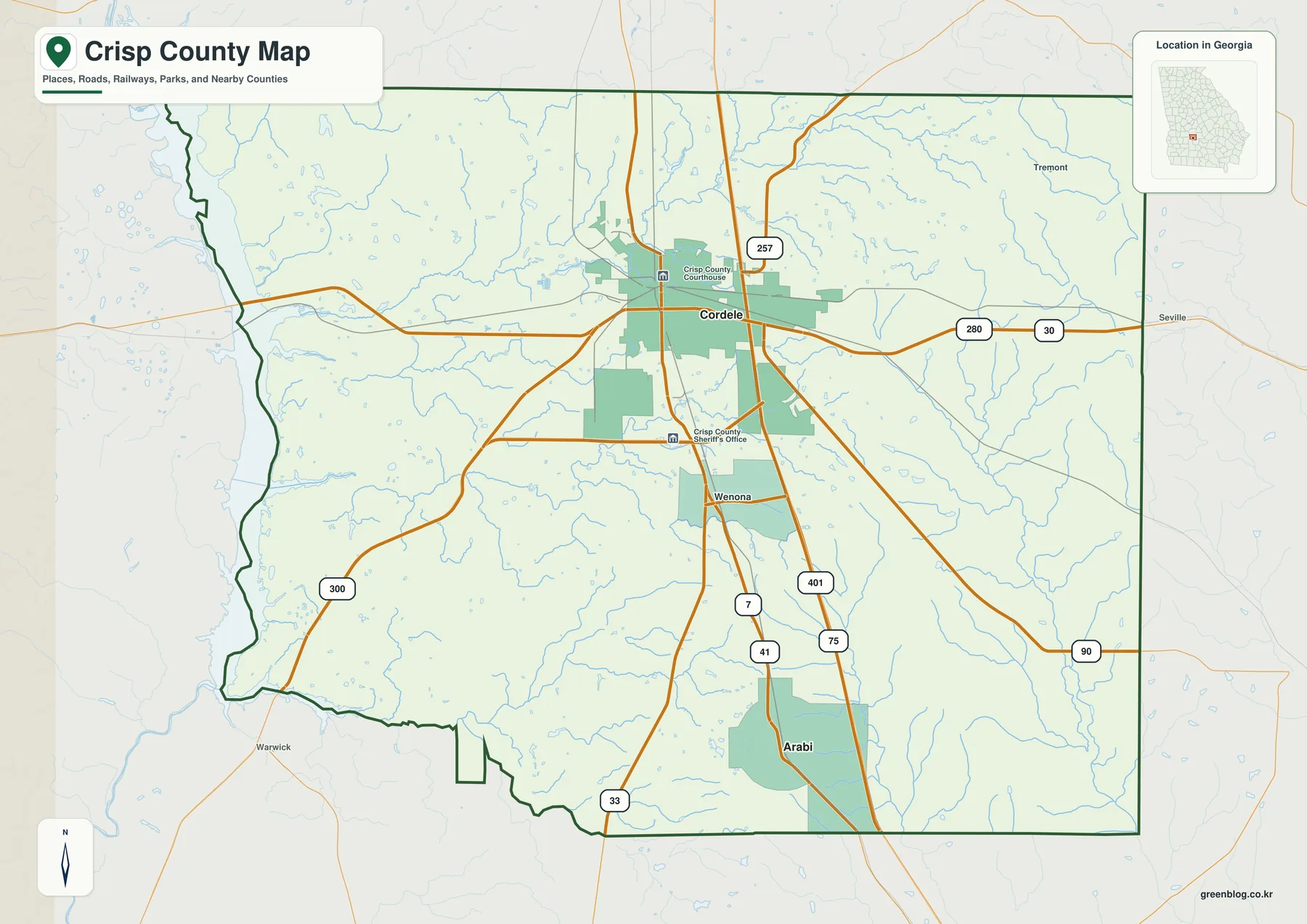
Cordele is not only the county seat but also the main transportation and commercial center. The verified material in the package notes that several rail lines helped earn Cordele the “Hub City” name, and the modern overlap of rail, Interstate 75, U.S. 41, and U.S. 280 continues that transport role. The Georgia Ports Authority also describes the Cordele Inland Port as a rail-linked terminal connecting cargo from Georgia, Alabama, and Florida with the Port of Savannah network.
Crisp County borders Dooly, Wilcox, Turner, Worth, Lee, and Sumter counties. The outer labels on the city map make this surrounding geography easy to see: Dooly is north, Wilcox and Turner are east, Worth is south, and Lee and Sumter are west. The map is useful for countywide orientation, but it does not provide lane counts, live traffic, construction status, or turn-by-turn routing.
The U.S. Census Bureau counted 20,128 residents in 2020 and estimated 19,237 residents on July 1, 2025. Land area was 272.68 square miles in 2020, with a population density of 73.8 people per square mile. Those numbers describe the whole county, not the density of Cordele itself. Settlement is much more concentrated around the city and selected lakefront areas than across the broad agricultural interior.
Cordele and Arabi on the ranked city map
The city map shows two major incorporated cities. Its City Index lists Cordele at 9,994 and Arabi at 550, a large difference that matches their distinct roles in the county. Cordele sits near the center of the road network and carries the county-seat and commercial functions, while Arabi is a much smaller city near the southern part of the county.
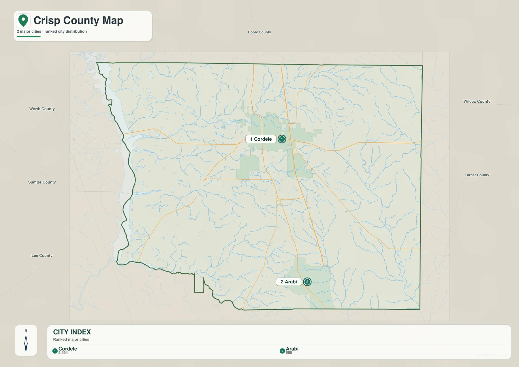
The north–south relationship is easy to follow when the city layer is compared with Interstate 75 and U.S. 41. From Cordele, those major routes continue south toward Arabi, with Wenona shown between the two on the general county map. Other communities are not necessarily absent from the county simply because they are missing from the city ranking. Existing local history material refers to places such as Hatley, Raines, and Wenona, but the ranked layer is intended to highlight incorporated cities rather than every rural community.
Both Cordele and Arabi grew during the late nineteenth-century railroad era, but Cordele gained the much larger regional role because several lines converged there. That transport advantage still matters today. The inland-port connection, Interstate 75 access, and east–west U.S. 280 corridor make Cordele a useful base point for explaining how the county connects farm production with regional and national freight networks.
Flint River, Lake Blackshear, and the smaller creek network
The strongest water feature is the Flint River along the western side. The verified county material explains that Lake Blackshear is the reservoir formed when the Crisp County Power Commission dammed the river in 1930. The commission reports about 8,700 acres of water, 97 miles of shoreline, an average depth of 11 feet, and a normal full-pool elevation of 237 feet above mean sea level. That long reservoir corridor gives the western county a very different character from the farm and upland areas farther east.
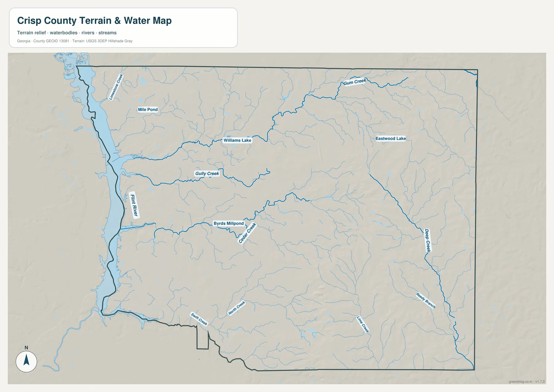
The water map also labels Gum Creek, Gully Creek, Cedar Creek, and Deep Creek, along with smaller channels such as Swift Creek and Little Creek. Williams Lake, Eastwood Lake, Byrds Millpond, and Mile Pond add a set of smaller named water bodies. Together these features show that the interior is crossed by many small streams even though the Flint River is the dominant large watercourse.
Lake Blackshear is also tied to the county’s public-power history. The Power Commission was created in 1925 to develop the Flint River for hydroelectric power, and generation began in August 1930. The commission then extended electric distribution into rural areas that had lacked service. Georgia Veterans State Park, established in 1946, occupies a prominent lakefront area and adds recreation, military exhibits, and the SAM Shortline excursion service to the western side of the county.
This map is a water-reference layer, not a flood or navigation product. It does not show flood zones, water depth, current streamflow, boat access, private property, or shoreline permits. Use the responsible local agency, FEMA, or other current operational sources when those details matter.
Lower Flint River ground and higher eastern ridges
The elevation surface shows a pronounced west-to-east contrast. Its legend reports an actual range of about 71 to 146 meters and a mean of about 103 meters. The Flint River and Lake Blackshear side is dominated by lower green terrain, while the eastern and southeastern parts of the county contain higher yellow, orange, and brown ridges cut by narrow valleys.
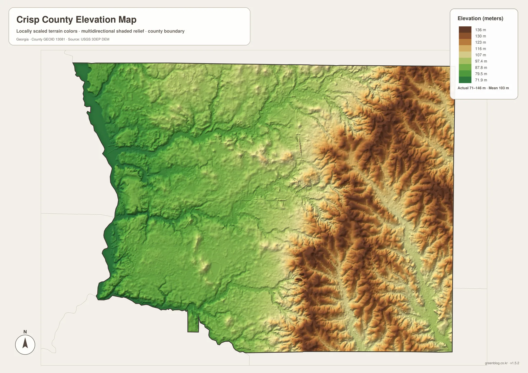
The eastern half is not one smooth plateau. The shaded relief contains many short ridges and incised valleys, making the terrain look much more broken than the road map suggests. On the west, the broader low ground aligns with the Flint River corridor. Comparing the elevation and water layers helps show how streams occupy lower channels while higher ground separates neighboring drainage paths.
The elevation values are intended for countywide comparison. They are not a survey of an individual property and should not be used for building design, road grades, precise drainage engineering, or legal elevation decisions. For those uses, consult the underlying USGS 3D Elevation Program data or a professional survey.
Agriculture, freight, and the history behind the map
Georgia created Crisp County from southern Dooly County in 1905 and named it for Charles Crisp, who served as Speaker of the U.S. House of Representatives from 1891 to 1894. Cordele became the county seat. Railroad expansion had already made Cordele and Arabi important local places, and Cordele’s convergence of rail lines set the pattern for its later highway and freight role.
The 2022 Census of Agriculture counted 176 farms covering 121,261 acres. Farms sold about $91.01 million in agricultural products, with crops accounting for 84 percent of sales. Cotton occupied 47,238 acres and peanuts 12,744 acres. Cordele is widely associated with watermelons, but these figures show that the county’s agricultural base also includes very large acreages of other field crops.
The Cordele Inland Port connects this farm and industrial region with the Port of Savannah by rail. Looking first at the county map makes that relationship easier to understand: highways and rail lines converge near Cordele, while farms extend across much of the surrounding county. Lakefront recreation on the west, agricultural production inland, and freight movement around Cordele therefore represent three distinct parts of the local economy.
How to choose the right map for a local question
For basic orientation, start with the county map and use Cordele as the anchor. From there, Arabi is south, Interstate 75 and U.S. 41 run north–south, U.S. 280 crosses east–west, and the Flint River lies to the west. The city map is best when you need to compare the two incorporated cities. Use the water map for the river, reservoir, creeks, ponds, and small lakes, then switch to the elevation map when the main question is why the western side is lower and the eastern side is more strongly ridged.
- Orientation: Locate Cordele, Arabi, Interstate 75, U.S. 41, and U.S. 280.
- City comparison: Use the ranked city layer to compare Cordele and Arabi.
- Water: Trace the Flint River, Lake Blackshear, Gum Creek, Gully Creek, Cedar Creek, and Deep Creek.
- Terrain: Compare the lower western river corridor with the higher eastern ridges.
- Large-format use: Download the ZIP for the four high-resolution A3 JPG originals.
These maps work well for general reference, education, presentations, and regional orientation. They are not substitutes for parcel surveys, zoning maps, flood studies, live traffic information, shoreline permits, or precise engineering elevations. Use the responsible county, state, or federal source when a decision depends on legal boundaries or detailed measurements.
Frequently Asked Questions
Which incorporated cities are shown in Crisp County?
The ranked city map shows Cordele and Arabi. Cordele is the county seat and the much larger urban center, while Arabi is a smaller incorporated city to the south. Other named rural communities may appear in local history or detailed road data without being included in this ranked city layer.
Is Lake Blackshear a natural lake?
No. It is a reservoir created on the Flint River when the Crisp County Power Commission completed its hydroelectric project in 1930. The lake is tied to both the county’s public-power history and its modern recreation and lakefront landscape.
What is the main elevation contrast across the county?
The western Flint River and Lake Blackshear side is lower and gentler, while the eastern and southeastern parts of the county contain higher ridges and narrow valleys. The supplied elevation legend reports an actual range of about 71–146 meters and a mean near 103 meters.
What is included in the download ZIP?
The archive contains four original high-resolution A3 JPG files: the county road-and-boundary map, ranked city map, water map, and elevation map. The WebP images in the article are smaller previews for browser viewing.
Map File Information
Crisp County Map Files
- Included Files: County road-and-boundary map, ranked city map, water map, and elevation map
- File Type: Four high-resolution A3 JPG files in one ZIP archive
- Intended Use: Printing, education, presentations, and map-based projects
Related Maps
- A Clinch County Map
- A Columbia County Georgia Map
- Adel and Little River on the Cook County Georgia Map
Sources and References
Population, area, agriculture, history, and reservoir facts follow the verified material preserved in the package. The supplied map previews support the road, water, and elevation descriptions. For updated statistics or legal boundaries, check the current agency record.
- U.S. Census Bureau QuickFacts: Crisp County, Georgia
- USDA 2022 Census of Agriculture: Crisp County profile
- New Georgia Encyclopedia: Crisp County
- Georgia Department of Community Affairs: Crisp County comprehensive plan
- Crisp County Power Commission: Lake Blackshear
- USGS 3D Elevation Program
Green Map creates custom-edited map images using open geographic data sources such as geoBoundaries, Natural Earth, OpenStreetMap, and government open data. These maps are edited visual materials, not raw data files, and are provided for education, documents, presentations, and graphic reference.