Crawford County sits west of Macon in central Georgia, where Roberta forms the clearest road junction while the Flint River and the Echeconnee Creek system pull drainage toward opposite sides of the county. The maps on this page separate that geography into county roads and boundaries, incorporated-city distribution, waterways, and elevation. For a larger version than the WebP previews, you can download four high-resolution A3 JPG maps together in one ZIP.
One detail makes Crawford County different from many county-map pages: the county seat and the incorporated city are not the same place. Knoxville is the unincorporated county seat, and Roberta, about one mile to the west, is the county’s only incorporated city and its main commercial center. The new city map therefore shows Roberta as the single ranked city, while the broader article still needs Knoxville to explain county government and local history. The Census Bureau estimated 12,206 county residents on July 1, 2025, so the page is best read as a rural-county map rather than a suburban growth map.
Table of Contents
Roberta at the center of the road network
The county map places Roberta close to the geographic center and shows several numbered routes meeting around it. U.S. 80 runs east–west, while U.S. 341 and Georgia 7 continue south from the central junction. Georgia 42 heads southeast, Georgia 22 reaches west, and Georgia 128 and 96 serve the southwest side. Musella appears in the northwest, adding a useful rural reference point beyond the Roberta label.
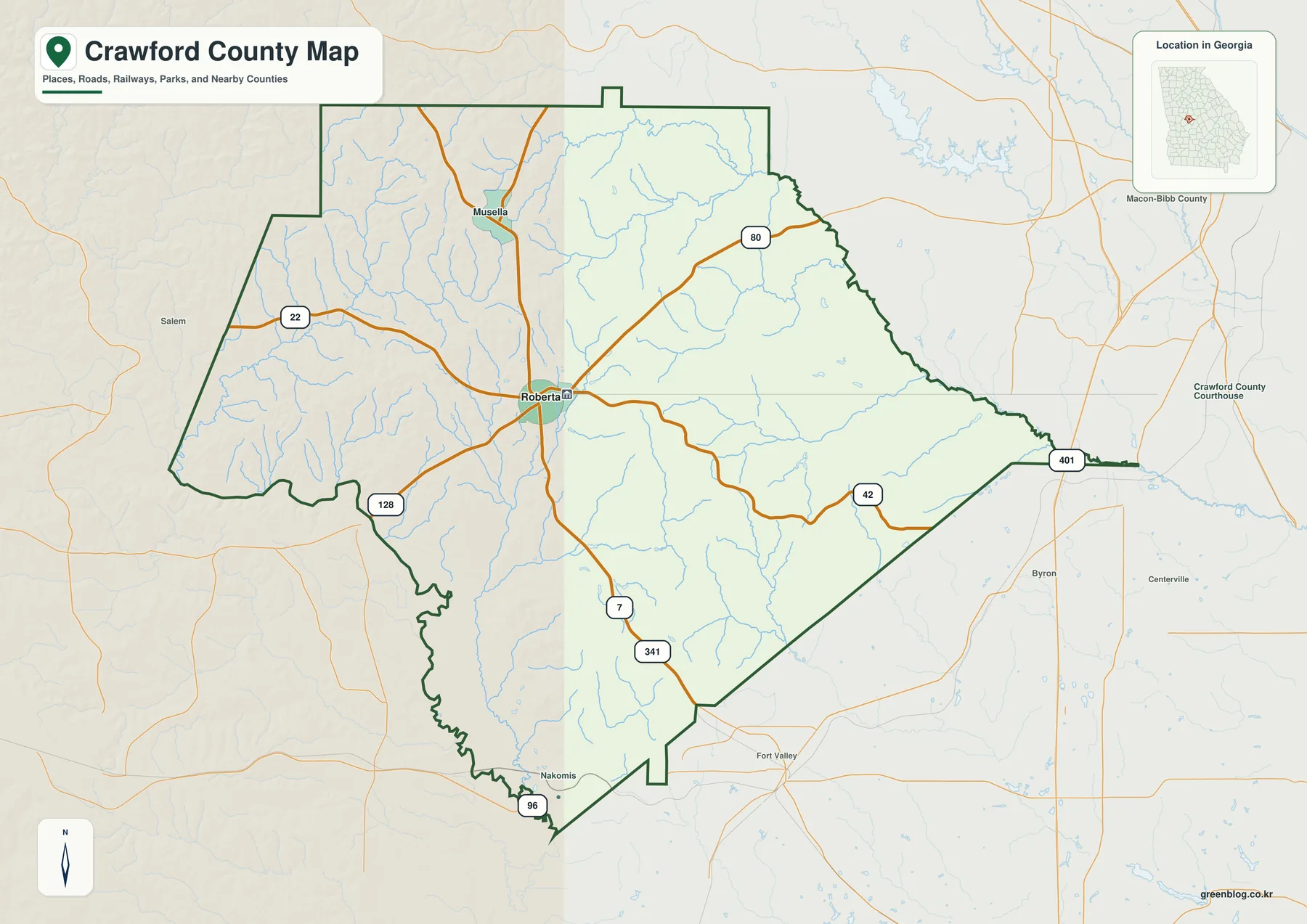
Those lines explain why a small rural county can still have a clear transportation center. U.S. 80 leads east toward Macon and west across central Georgia. U.S. 341 and Georgia 7 link the central county with the Fort Valley direction and other communities to the south and southeast. The map is useful for orientation, but it does not show current traffic, road construction, lane counts, or travel time, so a current state road source or navigation service is still needed for trip planning.
Crawford County borders Monroe County on the north, Bibb on the northeast, Peach on the southeast, Macon County on the south, Taylor on the southwest, and Upson on the northwest, with a very short contact with Houston County on the east. Those neighbors matter because many trips from Crawford lead toward the Macon and Fort Valley sides rather than staying entirely within the county.
Population is spread thinly beyond the central junction. Density was 37.3 people per square mile in 2020, down from 38.9 in 2010. That countywide number should not be treated as Roberta’s local density: the settlement around the central road junction is more concentrated than the large stretches of woodland, farms, and small communities around it.
Why Roberta is the only ranked city
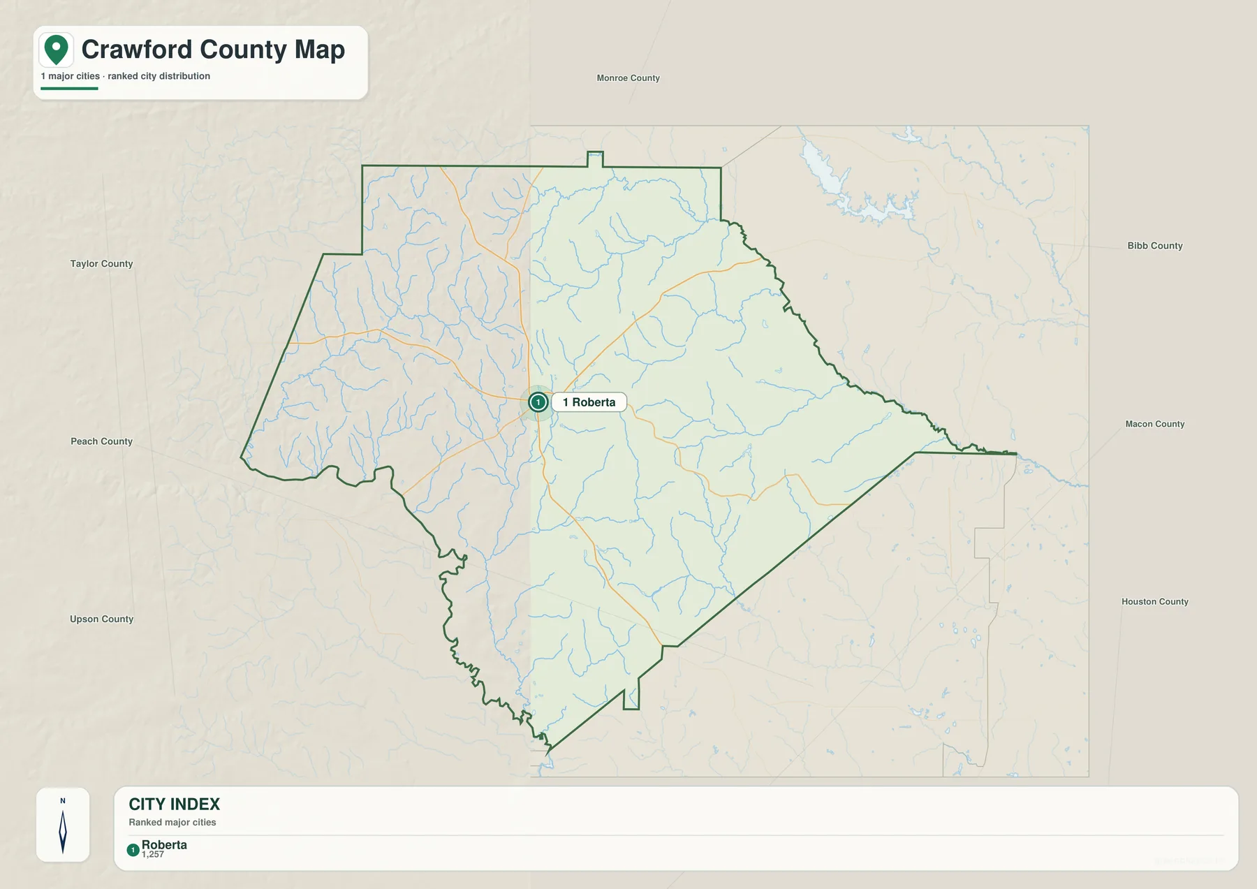
The city map lists one major incorporated city, Roberta, with a City Index value of 1,257. Knoxville is missing from this layer for a legal reason rather than a mapping error. It is the official county seat but is not an incorporated municipality. Roberta is incorporated and carries much of the commercial and municipal activity, so the city map and the county-government story point to two different nearby place names.
The arrangement grew out of transportation history. The verified material in the package describes Knoxville as an early center on the Federal Road, a stagecoach and telegraph route between Washington and New Orleans. In the 1880s, the railroad passed roughly a mile west of Knoxville, and a depot settlement called New Knoxville developed beside the tracks. It incorporated as Roberta in 1890, shifting much of the population and commerce while Knoxville retained county-seat status.
Knoxville remains important even without city incorporation. A courthouse completed in 2002 stands behind the historic courthouse, and the preserved county material notes that Georgia has only three unincorporated county seats. That makes Crawford a useful example of why “county seat,” “largest town,” and “incorporated city” are not interchangeable categories.
The ranked city layer also should not be read as a complete list of every community. Musella appears on the general county map, and existing local material refers to other small places such as Gaillard, Lee Pope, Horns, and Zenith. A detailed county GIS or local road dataset is the better source when those smaller communities, individual addresses, or parcels matter.
Flint River on the west, Echeconnee drainage on the east
The water map makes Crawford County’s divided drainage pattern much easier to see. The Flint River follows much of the western edge. On the opposite side, Echeconnee Creek and Little Echeconnee Creek occupy the northeast and east, with Sweetwater Creek joining the eastern network. Spring Creek and Indian Creek cross the interior, Beaver Creek follows the southwest side, and smaller named water bodies include Lake Henry and Hortons Mill Pond.
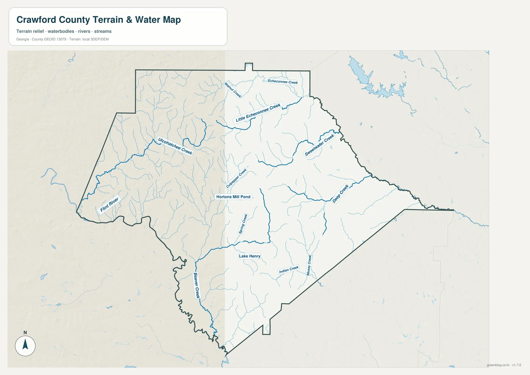
The existing geographic notes explain that an interior upland separates two large drainage systems. Land west of Musella and Knoxville drains toward the Upper Flint. The northeast drains toward the Upper Ocmulgee and the southeast toward the Lower Ocmulgee. In other words, Crawford County spans both the Apalachicola–Chattahoochee–Flint basin and the Altamaha basin, even though no single large river crosses its center.
The Flint River is therefore a boundary feature more than an interior spine. Echeconnee Creek plays a similar edge role on the east before continuing toward the Ocmulgee River. The smaller creeks in between descend away from higher ground toward one side or the other. This is a useful pattern for understanding the county, but the map is not a flood study or a stream-flow chart. It does not provide water depth, flood elevation, current discharge, or parcel-level drainage limits.
Road and water layers work especially well together here. The U.S. 341/Georgia 7 corridor lies near the central upland divide, while streams on either side lead toward different river systems. That relationship helps explain how a county with relatively little large open water can still be strongly organized by drainage. Use USGS National Hydrography or current local GIS data when exact stream geometry is required.
The Fall Line and a 86–221 meter elevation range
The elevation map shows far more relief than a simple road map suggests. Its legend reports an actual range of about 86 to 221 meters and a mean of about 146 meters. Higher brown and orange terrain spreads across much of the north and central interior. Lower green areas follow the Flint River side, the southwest, and several creek valleys toward the east. Numerous short ridges and narrow valleys give the county a rolling texture.
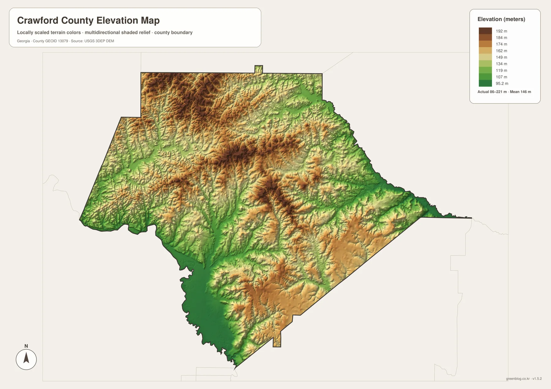
The preserved background material places the Fall Line near Roberta. Piedmont bedrock and hillier terrain characterize the north, while Cretaceous Coastal Plain deposits and Sand Hills become more important to the south. That transition should not be reduced to a simple “hills north, flat land south” rule. The supplied elevation surface still shows ridges in the southern half, while the Flint and Echeconnee valleys cut distinctly below nearby uplands.
Comparing water and elevation reveals why the divided drainage works. Lower green corridors commonly match the larger streams, while higher ridges separate neighboring drainage paths. The Flint valley stays low along the western margin, and the Echeconnee system occupies lower ground on the east. Between them, the higher interior provides the divide that sends runoff toward different major basins.
The 86–221 meter values are suitable for countywide comparison, not for a survey of a specific property. A road grade, building site, drainage design, or precise lot elevation requires the underlying USGS 3D Elevation Program data or professional survey information. The map’s strength is showing the relative pattern of ridges and valleys across the whole county in one view.
Rural land use, commuting, and practical map choices
Crawford County’s rural landscape is economically mixed. The 2022 Census of Agriculture counted 180 farms and 29,558 acres of farmland, with $93.757 million in agricultural products sold. Livestock, poultry, and related products accounted for 91 percent of sales. Poultry and egg sales alone were $84.089 million, and an inventory of 3,170,407 broilers shows why poultry is the county’s dominant commercial farm sector.
Crops were a smaller share of total sales, but fruits, tree nuts, and berries contributed $6.644 million. The verified county material also records 11,825 acres of farm woodland and 2,216 acres of forage land. That combination fits a landscape where poultry facilities, orchards, timber, pasture, and smaller farms appear together rather than as one continuous crop belt.
Commuting extends the local map beyond the county line. Workers had an average commute of 33 minutes in 2020–2024, while county employer establishments accounted for 694 jobs in 2023. Those figures support a labor market tied to Bibb, Peach, and Houston counties, especially Macon and the industrial and service centers east and southeast of Crawford. U.S. 80 and U.S. 341 therefore matter not only as map labels but also as links to work and services outside the county.
- For orientation: Start with Roberta, Musella, U.S. 80, U.S. 341, and the county boundary.
- For local government: Keep Knoxville’s county-seat role separate from Roberta’s incorporated-city role.
- For drainage: Compare the Flint River side with the Echeconnee Creek and Ocmulgee side.
- For terrain: Use the elevation map to distinguish higher interior ridges from lower river and creek valleys.
- For large-format use: Download the ZIP for the four high-resolution A3 JPG originals.
These maps are intended for general reference, education, presentations, and regional orientation. They are not substitutes for parcel surveys, zoning maps, school districts, flood studies, property ownership records, or current navigation. When a decision depends on legal boundaries or precise measurements, use the responsible county, state, or federal source.
Frequently Asked Questions
Is Knoxville really the county seat instead of Roberta?
Yes. Knoxville is the official county seat even though it is not an incorporated municipality. Roberta lies about one mile west, is the county’s only incorporated city, and functions as the main municipal and commercial center.
Why does the city map show only Roberta?
The city layer ranks incorporated cities. Roberta is Crawford County’s only incorporated city, while Knoxville is an unincorporated community with county-seat status. Smaller communities require the general county map or a more detailed local GIS layer.
Does the Flint River cross the middle of Crawford County?
No. The Flint River follows much of the western boundary. Echeconnee Creek and related drainage lie on the eastern side, with higher interior ground separating west-flowing Flint drainage from east-flowing Ocmulgee–Altamaha drainage.
What files are included in the download ZIP?
The ZIP contains four original high-resolution A3 JPG maps: county roads and boundaries, ranked city distribution, waterways, and elevation. The WebP images in the article are smaller previews for browser viewing.
Map File Information
Crawford County Map Files
- Included Files: General county, city, water, and elevation maps
- File Type: Four high-resolution A3 JPG files bundled in one ZIP archive
- Intended Use: Printing, education, presentations, and map-based projects
Related Maps
- A Clinch County Map
- A Columbia County Georgia Map
- Adel and Little River on the Cook County Georgia Map
Sources and References
Population, commuting, administrative, and agricultural details follow the verified material preserved in the package. Water and terrain descriptions use the supplied maps together with the official sources listed below. Check the current agency record when an updated statistic or legal boundary is required.
- U.S. Census Bureau QuickFacts: Crawford County, Georgia
- New Georgia Encyclopedia: Crawford County history and profile
- Georgia Department of Community Affairs: Crawford County–Roberta comprehensive planning records
- USDA 2022 Census of Agriculture: Crawford County profile
- USGS National Hydrography
- USGS 3D Elevation Program
Green Map creates custom-edited map images using open geographic data sources such as geoBoundaries, Natural Earth, OpenStreetMap, and government open data. These maps are edited visual materials, not raw data files, and are provided for education, documents, presentations, and graphic reference.