Seminole County sits in Georgia’s southwest corner, where the road network around Donalsonville and Iron City gives way to a much wetter southern landscape along the Chattahoochee River, Spring Creek, and the broad reservoir waters near the county’s southern tip. This page is designed to make those differences easy to see rather than treating the county as a single generic outline. You can review four WEBP previews here and download the same four map themes as high-resolution A3 JPG files in one ZIP: the county reference map, city distribution map, terrain-and-water map, and elevation map. Together they show where the county’s settlement and roads are concentrated, how the waterways cross the interior, and why the southern shore and river margins sit lower than the northern uplands.
The maps are general reference products, not parcel, flood-risk, engineering, or navigation maps. They work best for county orientation, classroom geography, reports, and visual comparisons between roads, towns, waterways, and relief. Because each version uses the same county boundary, a place found on one map can be compared directly with the same part of the county on the others.
Table of Contents
Donalsonville anchors a road network concentrated in the north
The county reference map places Donalsonville near the north-central part of Seminole County and shows Iron City farther east. Route 84 forms the clearest east–west connection between the two incorporated places, while Route 38 and a north–south road meet the Donalsonville area. A Route 45 marker appears near Iron City. This concentration of named places and road lines in the northern part of the county is one of the most useful first impressions: settlement is not spread evenly from north to south.
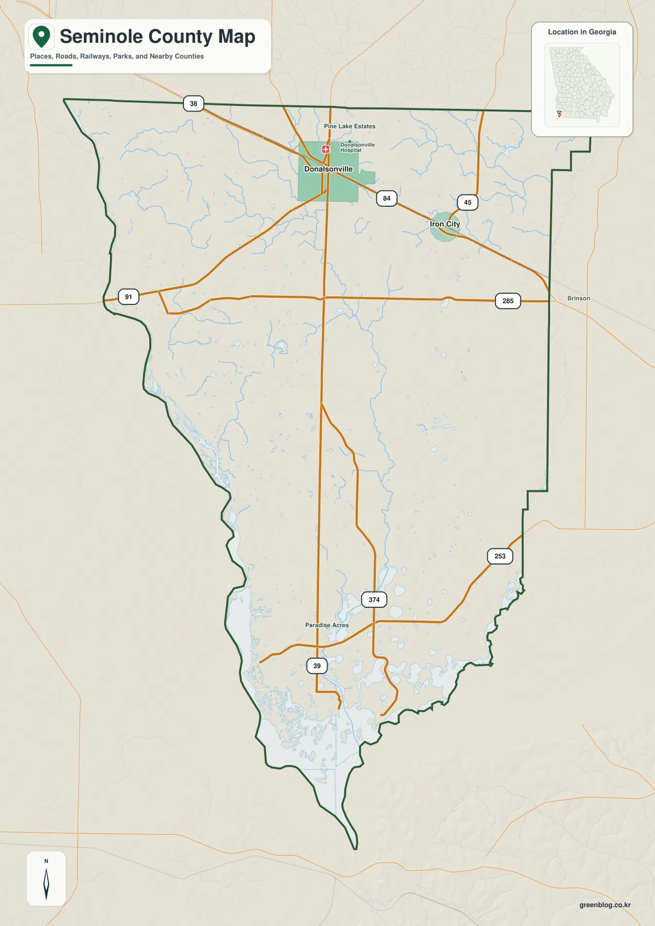
South of the two towns, the road pattern becomes more widely spaced. Routes 91 and 285 run across the upper-middle part of the county, while markers for 39, 253, and 374 appear farther south. The county outline also stretches much farther toward the reservoir than the settlement labels might suggest. For readers who arrive looking only for Donalsonville, the full county map is useful because it shows how much of Seminole County lies south of the main population center.
The surrounding-county labels on the city map help place Seminole County within southwest Georgia. Miller County is shown to the north, Decatur County to the east, and Early County to the west. The county reaches the Florida border on the south. That position helps explain why the page is useful not only as a local town map but also as a regional reference for travel and geography near the Georgia–Florida line.
A two-city pattern makes the northern settlement focus easy to see
The city distribution map strips away many of the road labels and emphasizes the two ranked places used in the map set. Its City Index lists Donalsonville at 2,831 and Iron City at 371, with Donalsonville ranked first and Iron City second. Those figures are the values printed on the supplied city map; they should be read as the map’s comparison values rather than as a substitute for a current population estimate.
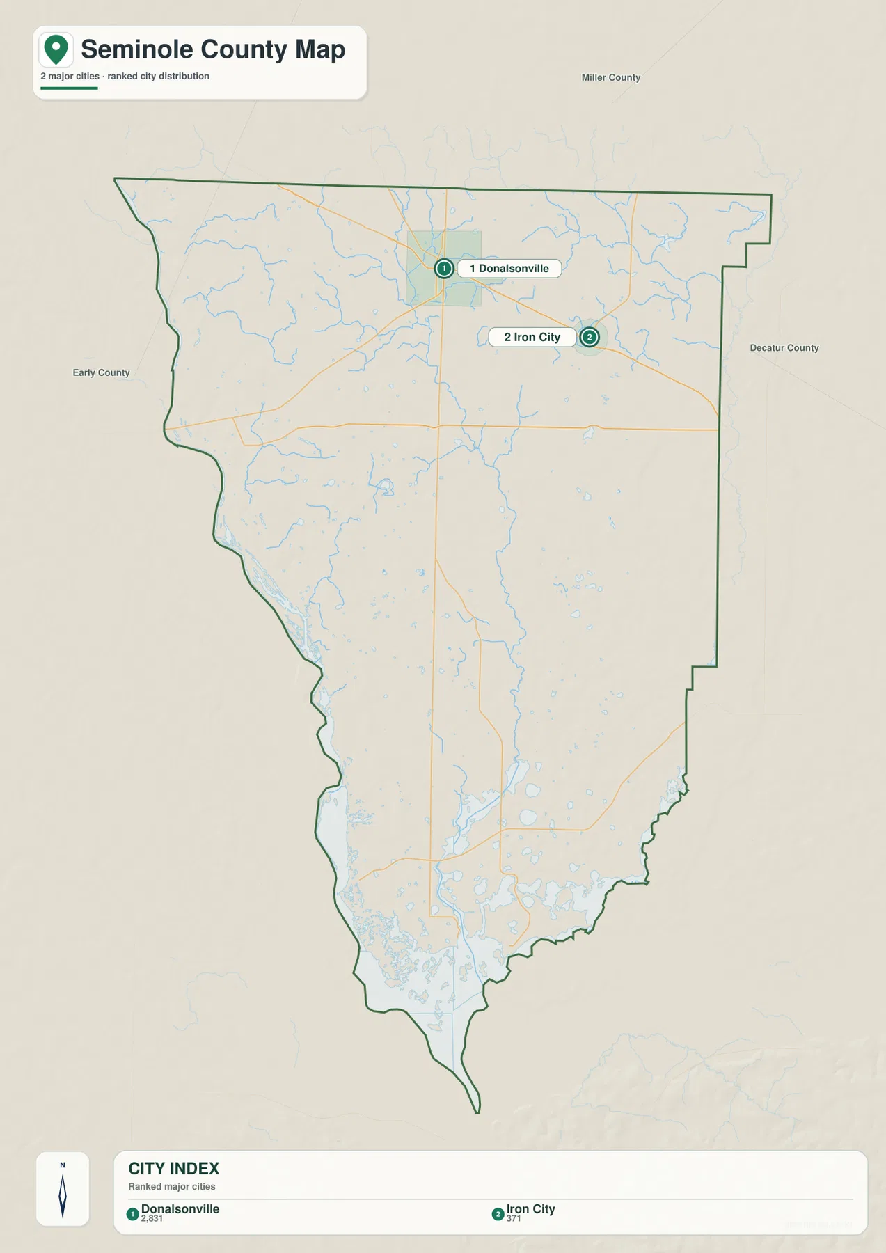
The map is especially helpful for explaining why Donalsonville functions as the county’s main reference point. It is the county seat, it lies at a cluster of road connections, and it is shown with the larger city-index value. Iron City is farther east along the same general northern road corridor. No comparable ranked city appears in the central or southern half of the county, so the rest of the map is better understood through roads, creeks, ponds, and the reservoir shoreline rather than through a chain of towns.
Unlike some county city maps, this version does not present connector-mile distances between several ranked places. That means it should not be used to infer a straight-line or driving distance that is not printed on the map. Its purpose is simpler: to show the relative positions and ranked prominence of the two labeled cities within the county boundary.
The Chattahoochee River and Spring Creek lead toward the reservoir
The terrain-and-water map changes the emphasis completely. Along the west side, the Chattahoochee River follows a long section of the county edge. Through the interior, Spring Creek runs southward in a curving channel and collects smaller tributaries before reaching the lower part of the county. The contrast with the road map is striking: the important natural lines bend through low ground instead of following the straighter road grid.
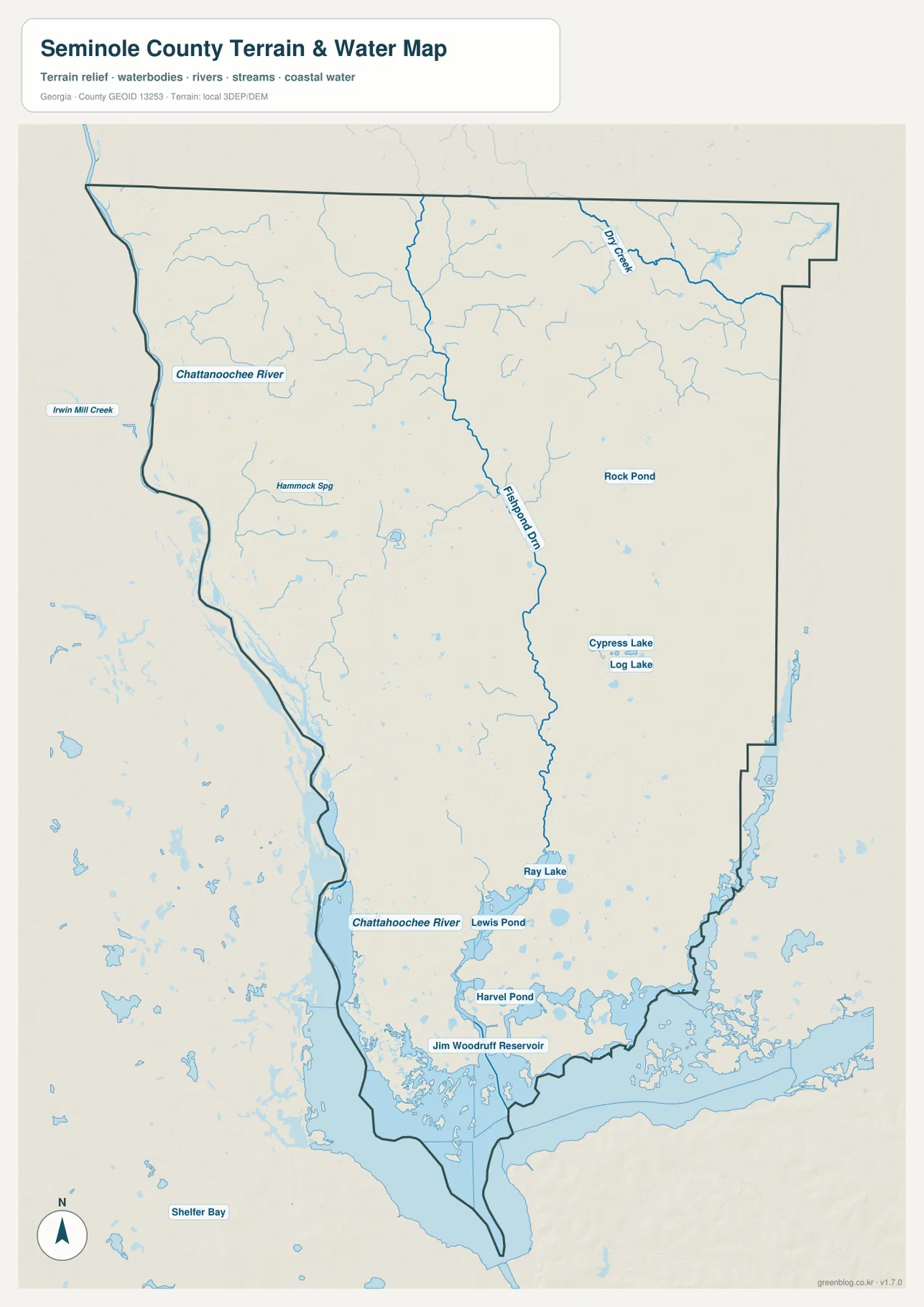
Several named water features provide useful local reference points. Rock Pond appears in the eastern half of the county, while Cypress Lake and Log Lake sit farther south. Ray Lake, Lewis Pond, and Harvel Pond are labeled near the lower part of the county. At the south end, the map labels Jim Woodruff Reservoir, where the water surface becomes much broader and more intricate. This reservoir area is associated with Lake Seminole, a defining feature of the county’s southern landscape.
The supplied map also shows many smaller unnamed channels and water bodies, especially toward the south. Readers should not treat every blue shape as a recreational lake or every creek line as suitable for navigation. The map is intended to show the county’s hydrographic pattern and named reference features. For flood zones, boating routes, property boundaries, or legal water limits, the appropriate specialized source should be consulted instead.
Looking at the Chattahoochee and Spring Creek together also explains the county’s elongated water-oriented south. One major river defines the western side, while the interior creek carries drainage toward the broad reservoir system. The northern towns therefore occupy a different visual setting from the southern county, where water features become more numerous and the shoreline more complicated.
Elevation ranges from about 23 to 63 meters across a low-relief county
The elevation map reports an actual county range of roughly 23 to 63 meters and a mean elevation of about 37 meters. Seminole County is not mountainous, but the locally scaled colors reveal meaningful differences inside that modest range. Brown and tan areas are concentrated mainly across the north and northwest, where the ground is relatively higher. Green becomes more prominent toward the Chattahoochee corridor, the southern interior, and the reservoir margins.
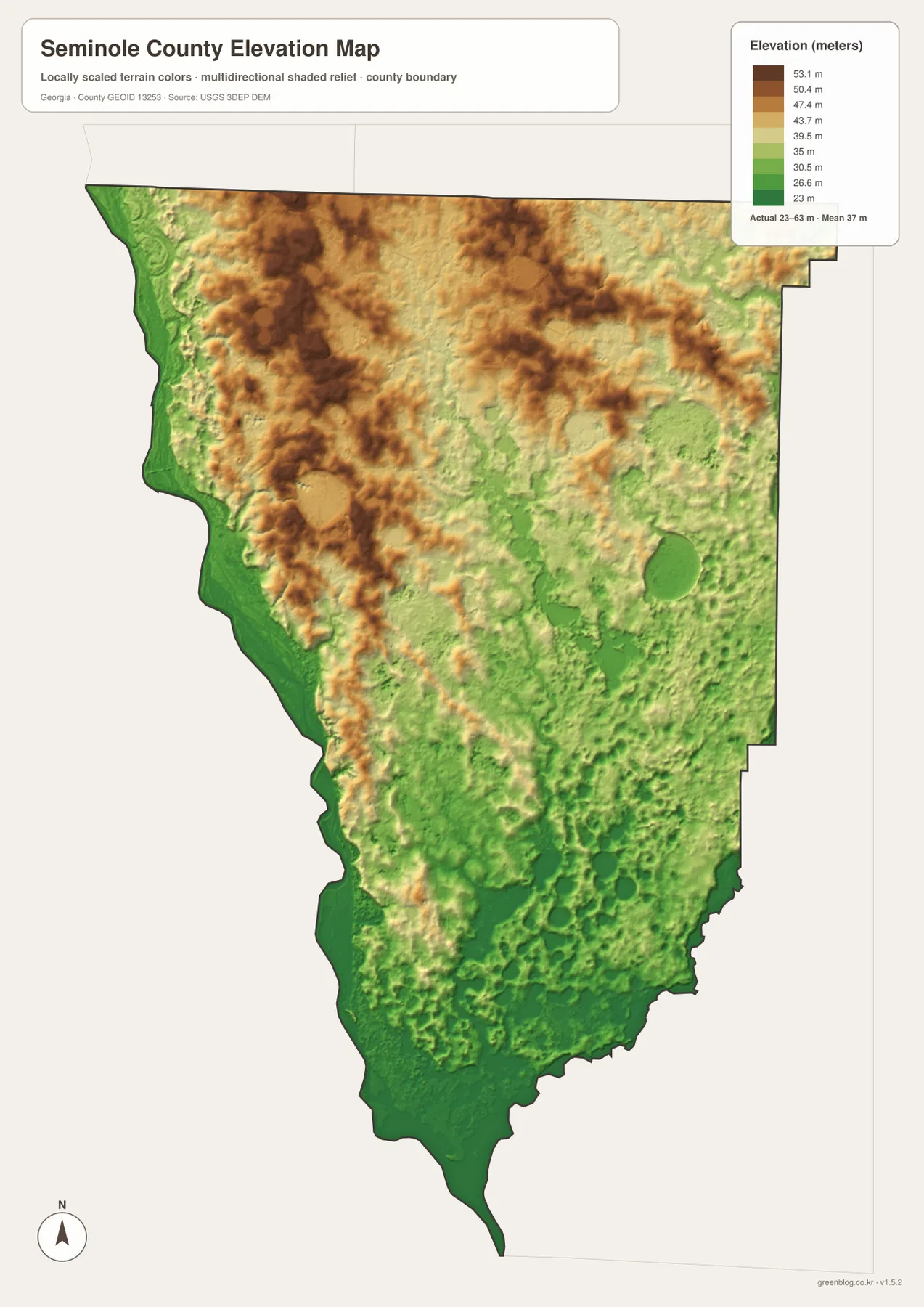
Because the map uses colors scaled to the county’s own elevation range, a dark brown patch should not be mistaken for a mountain. It simply marks land that is high relative to other parts of Seminole County. The strongest regional relationship is the gradual change from the higher northern surface toward lower drainage corridors and the southern reservoir. Spring Creek is easier to understand when this map is viewed beside the water map, because its channel follows a lower path through the interior.
The elevation surface is generalized and is appropriate for county-scale comparison rather than site engineering or surveying. It can show which side of the county is relatively higher and where broad low areas coincide with major waterways, but it should not be used to determine the exact elevation of a house, road crossing, shoreline parcel, or construction site.
Roads in the north and water in the south define the county at a glance
When all four maps are compared, Seminole County has a clear north–south contrast. Donalsonville and Iron City occupy the north, and the strongest concentration of named roads is found around them. Farther south, the map becomes less about settlement and more about Spring Creek, ponds, shoreline, and reservoir water. The elevation map reinforces the same transition by showing relatively higher ground in the north and lower terrain along the major drainage and reservoir margins.
This comparison is useful because no single map has to carry every detail. A reader studying county access can start with Donalsonville and Route 84. Someone interested in natural geography can move directly to the Chattahoochee River, Spring Creek, and the reservoir. A lesson on terrain can then use the 23–63 meter elevation range to explain why the water network occupies broad low areas even though the county lacks large mountains.
The maps also prevent a common misunderstanding created by the county’s long shape. The northern urban labels can make the southern half seem empty on a settlement map, but the water map shows that it is visually complex and contains many creeks, ponds, and shoreline features. In other words, “fewer towns” does not mean “fewer geographic features.” The dominant information simply changes from human settlement to water and terrain.
Choose the map file that matches the question you need to answer
For a general report or presentation, the county reference map is the quickest way to establish the boundary, Donalsonville, Iron City, and the main labeled routes. The city map provides a cleaner view of the two ranked places without the heavier road detail. If the subject is Lake Seminole, the Chattahoochee River, Spring Creek, ponds, or shoreline geography, the water map is more informative. The elevation version is best when the goal is to compare the higher north with the lower river and reservoir margins.
The WEBP images on the page are optimized for browsing. The downloadable package keeps the four themes as high-resolution A3 JPG files, which are better suited to printing, archiving, classroom handouts, and inserting into documents. Since the files share the same county extent, readers can switch between them without having to relearn the basic orientation.
Frequently Asked Questions
Why does the city map emphasize only Donalsonville and Iron City?
The supplied city map is a ranked-major-city view, and its City Index contains Donalsonville and Iron City. It is not intended to label every unincorporated community, crossroads, or rural settlement in Seminole County.
Where is the large Lake Seminole reservoir area on these maps?
The broad water area is at the southern end of the county. The supplied water map labels Jim Woodruff Reservoir and shows the Chattahoochee River and Spring Creek feeding toward that reservoir system, along with many smaller lakes and ponds.
How much elevation change is shown within Seminole County?
The elevation map reports an actual range of about 23 to 63 meters, with a mean near 37 meters. The northern part of the county is generally higher, while major river, creek, and reservoir margins occupy lower ground.
Sources and reference links
These links provide additional county background and official data resources for boundaries, hydrography, and elevation.
- U.S. Census Bureau QuickFacts for Seminole County
- New Georgia Encyclopedia: Seminole County
- U.S. Census Bureau TIGER/Line boundary data
- USGS National Hydrography
- USGS 3D Elevation Program
Map File Information
The ZIP contains four high-resolution A3 JPG maps of Seminole County: county reference, city distribution, terrain and water, and elevation.
- Included Files: County map · City map · Water map · Elevation map
- File Type: One ZIP containing four high-resolution A3 JPG files
Related Maps
Green Map creates custom-edited map images using open geographic data sources such as geoBoundaries, Natural Earth, OpenStreetMap, and government open data. These maps are edited visual materials, not raw data files, and are provided for education, documents, presentations, and graphic reference.