Essex County occupies a distinctive corner of northeastern Massachusetts because its geography changes markedly from one part of the county to another. The southwest includes Lynn, Saugus, Peabody, and Salem near the urbanized North Shore. Farther northwest, Lawrence, Methuen, and Haverhill form a separate cluster in the Merrimack Valley. The northern edge reaches Amesbury, Salisbury, and Newburyport, while the eastern side extends onto Cape Ann around Gloucester and a deeply indented Atlantic shoreline. Roads, rivers, cities, harbors, and the coastline therefore work together as better reference points than any single county center.
This page provides a general county map, a major-city distribution map, and a terrain-and-water reference map, along with downloadable high-resolution JPG versions of the supplied files. The general map is the best starting point for locating Lynn, Salem, Lawrence, Haverhill, Newburyport, Gloucester, I-95, I-495, Route 1, and Route 128. The city map simplifies the county to six selected urban points, while the water map emphasizes the Merrimack, Ipswich, Annisquam, and Saugus rivers together with Salem Harbor, Massachusetts Bay, and the Atlantic Ocean.
Table of Contents
From Lynn to the Merrimack Valley and Cape Ann
The county outline is easiest to remember as a narrow southwestern urban area that opens toward a much broader north and east. Lynn and Saugus sit near the bottom of the county, with Peabody and Salem immediately to the north and northeast. Danvers provides another useful reference farther north. The inland northwest then shifts toward Lawrence, Methuen, and Haverhill, while the coast eventually bends outward into the Gloucester peninsula. This shape explains why a route between two Essex County communities can involve very different road systems and geographic settings even when both places are within the same county.
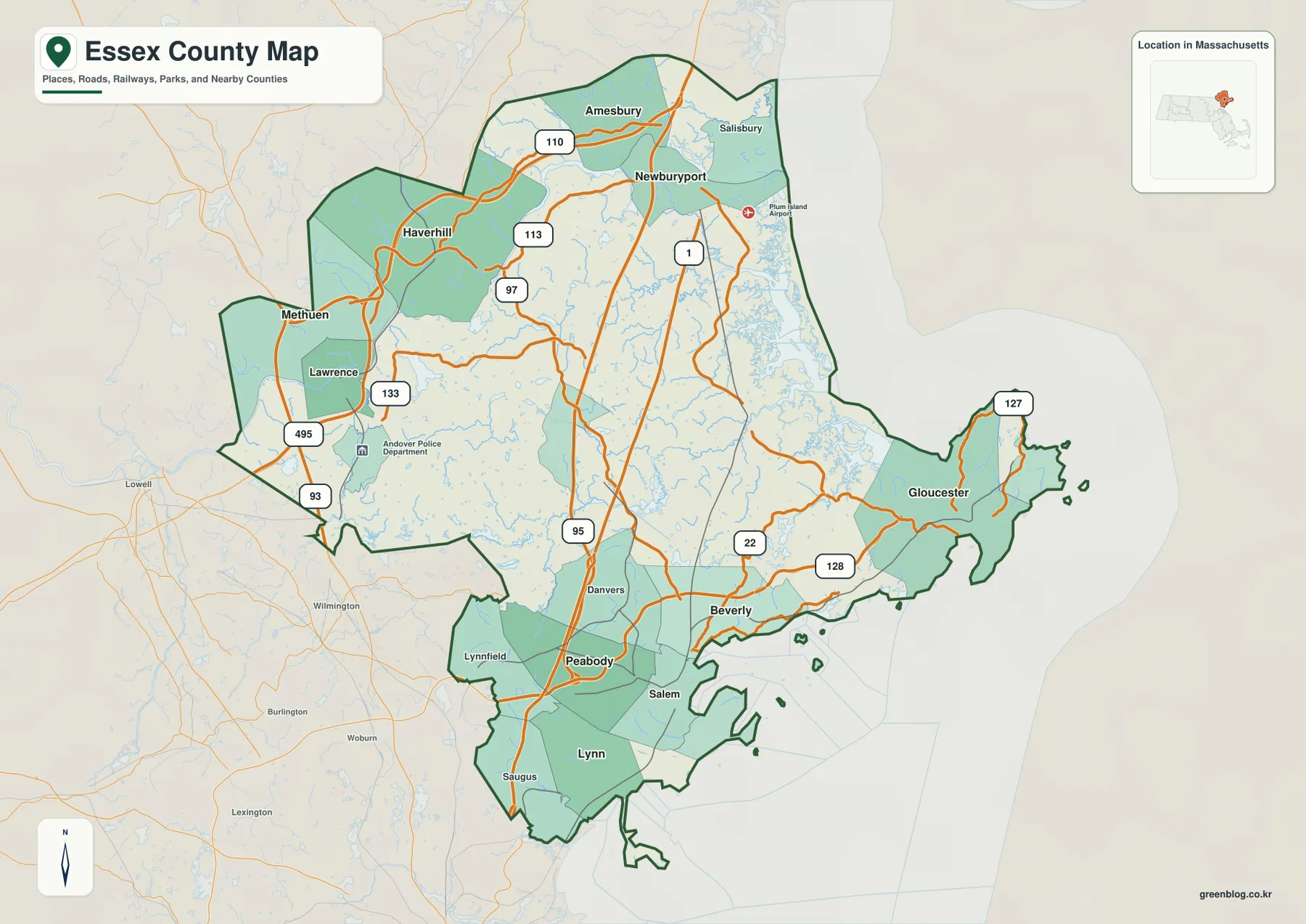
In the northwest, Lawrence and Methuen are close to the county’s western side, and Haverhill lies farther northeast. I-495 forms a major highway reference for this part of the map, while Routes 97, 110, and 113 help connect communities around Haverhill and the upper Merrimack Valley. This road pattern looks very different from the network near Salem or Gloucester. The northwestern cities are oriented around an inland river valley and interstate connections rather than a highly indented ocean shoreline.
Moving east from Haverhill, Amesbury and Newburyport become important northern anchors. Salisbury occupies the coastal area northeast of Newburyport, and both I-95 and Route 1 provide easy lines to follow through the northern part of the county. The coastline near the mouth of the Merrimack River becomes increasingly complex as river, estuary, marsh, and ocean environments meet. Newburyport is therefore a useful transition point: westward lies the Merrimack Valley, while eastward and southeastward the map becomes more strongly coastal.
The eastern county is dominated visually by Cape Ann and Gloucester. Gloucester projects toward the Atlantic and is tied back to the rest of the county by Route 128, with Route 127 providing another important coastal reference. As the map moves from Beverly toward Gloucester, roads and settlements become more closely related to coves, channels, headlands, and small offshore islands. The irregular outline is not simply decorative detail; it is one of the defining geographic differences between eastern Essex County and the inland Merrimack Valley.
The southern section has a denser grouping of places. Lynn, Saugus, Peabody, Salem, Beverly, and Danvers all appear within a comparatively compact area. Route 1 is useful around Peabody and Saugus, I-95 carries the larger north-south highway pattern farther north, and Route 128 becomes a key reference toward Beverly and Gloucester. Salem and Beverly are separated by coastal water, while Lynn and Saugus occupy a different shoreline setting on the southwestern edge. The general map makes these distinctions much easier to see than a simple list of city names.
Six city markers reveal two separate urban clusters
The major-city map removes most roads and secondary labels and highlights six ranked locations. Its CITY INDEX lists Lynn as 1, Lawrence as 2, Haverhill as 3, Peabody as 4, Methuen as 5, and Salem as 6. The numeric values printed beside the names are best treated as the values used to build this particular map layer rather than as a guarantee of current official population figures. For geographic reading, the important feature is the spacing of the markers and the way they form two distinct groups.
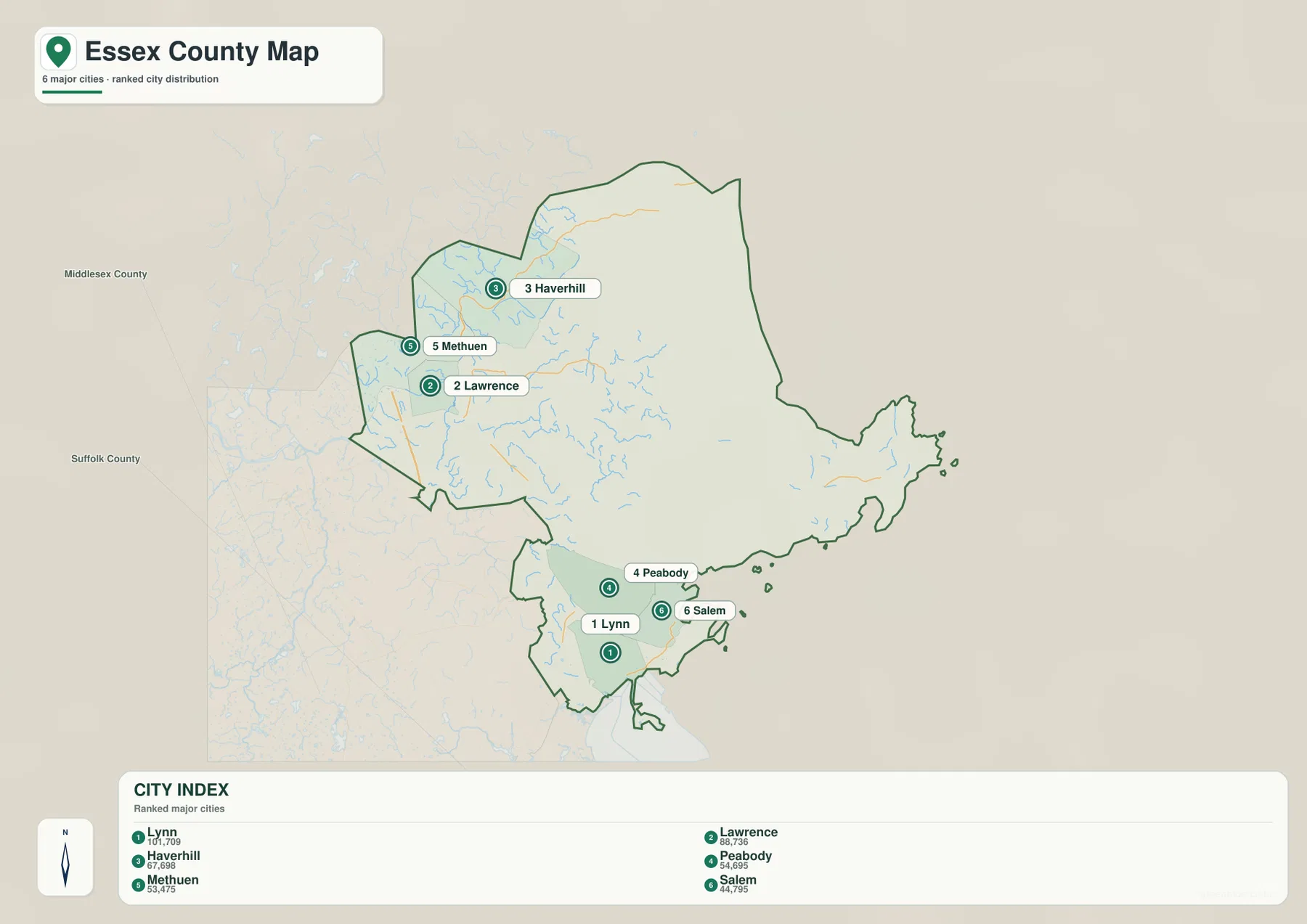
Lynn, Peabody, and Salem form the southwestern group near the North Shore and the Boston-facing side of the county. Lawrence, Methuen, and Haverhill form a separate northwestern group along the Merrimack Valley. A broad middle portion of the county lies between them. This is a useful reminder that Essex County does not have one continuous line of major cities running from south to north. The selected urban centers are divided by geography as well as distance.
Gloucester and Newburyport do not appear among the six ranked markers, even though both are extremely useful geographic anchors on the general map. That omission reflects the design of the city layer, not a lack of importance. Gloucester is essential for understanding Cape Ann and the Atlantic coast, while Newburyport is a key point near the mouth of the Merrimack River. When the subject is coastal geography, the city layer should therefore be paired with the general map and the water map rather than used by itself.
The Essex National Heritage Area describes the county as 34 cities and towns spanning the North Shore and Merrimack Valley. That regional framing fits the pattern visible here. If a reader focuses only on Lynn, Peabody, and Salem, the county can look primarily like a coastal urban area. If the focus shifts to Lawrence, Methuen, and Haverhill, it looks more like an inland river-valley county. Essex County is both, and the separation of the six markers makes that dual character unusually easy to explain.
Merrimack River, Ipswich River, and the Atlantic edge
The Merrimack River is the strongest inland water feature on the terrain-and-water map. It enters the county from the northwest, crosses the northern section, and continues toward its outlet near Newburyport. After locating Lawrence and Haverhill on the general map, switching to the water layer makes the idea of the Merrimack Valley immediately clearer because the large river provides a continuous geographic reference. Essex Heritage also identifies the Merrimack as a defining feature along the northern part of the region and connects it with the long industrial history of the valley.
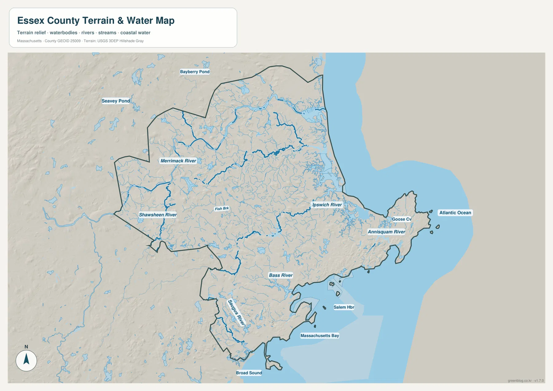
South of the Merrimack, many smaller streams branch through the interior. The Shawsheen River is labeled in the southwestern inland area, while the Ipswich River provides a clear eastward-running reference across the central part of the county. The water layer therefore adds detail that the road map intentionally suppresses. Areas that appear as broad blocks of land on the general map are crossed by numerous small channels, and some local geographic divisions make more sense once those waterways are visible.
Around Cape Ann, the Annisquam River and Goose Cove appear within Gloucester’s highly irregular coastal setting. The Atlantic Ocean opens immediately east of the peninsula. Comparing this layer with the general road map explains why Route 127 bends around the outer part of Cape Ann and why Route 128 approaches Gloucester from the interior side. The peninsula contains narrow waterways, coves, headlands, and offshore features, creating a far more intricate shoreline than the county’s inland boundary.
Farther south, the Saugus River is labeled near Lynn and Saugus, while Salem Harbor appears along the coast near Salem. Massachusetts Bay and Broad Sound occupy the larger waters beyond the southern shoreline, and the Atlantic lies farther east. These labels show that the southwestern urban cluster is not simply an inland extension of metropolitan Boston. It is also a coastal area shaped by harbors, tidal water, and narrow connections between land and sea.
The Essex National Heritage Area map describes a North Atlantic coast that includes extensive marshlands and beaches, especially in the northeastern portion of the region. The supplied water map likewise shows a dense network of small channels around the northern coast near Newburyport and Salisbury. This page’s map is a regional reference, however, not a regulatory wetland map, flood determination, tide model, or navigation chart. Site-specific environmental, safety, or permitting decisions require the appropriate current official source.
The shaded relief is intentionally broad. Essex County does not display the high mountain ridges that dominate parts of western Massachusetts, but inland relief still provides context for the tributary network and the transition toward low coastal areas. The shading can help distinguish a river valley from a more open coastal plain or peninsula, but it should not be used to estimate an exact elevation, road grade, flood threshold, or engineering condition. Its value here is regional orientation rather than measurement.
Following I-495, I-95, Route 1, and Route 128 across three parts of the county
A practical way to read the road network is to start with a different major route in each section. In the Merrimack Valley, I-495 is the clearest large-scale reference around Lawrence and Haverhill, with Routes 97, 110, and 113 adding local connections. In the north, I-95 runs toward Newburyport and Salisbury, and Route 1 provides another strong north-south line. These roads make it easier to connect the interior valley cities with the northern edge without tracing every smaller road.
In the southwest and central-south, Route 1 and I-95 help organize the area around Peabody and Danvers. Lynn and Saugus sit farther south, while Salem lies to the east and Beverly is across the coastal water to the northeast. This compact cluster can appear confusing when every local road is visible, so using Peabody as a road reference and Salem as a coastal reference makes the map easier to scan. From there, the route toward Cape Ann becomes much clearer.
Route 128 is the most useful road reference for Gloucester. It extends from the Beverly side toward Cape Ann and ties the coastal peninsula to the denser southern part of the county. Route 127 appears closer to the outer coastline and helps describe travel around the peninsula itself. The contrast with I-495 is instructive: one route belongs visually to the Merrimack Valley highway system, while the other responds to a peninsula where the coastline strongly shapes the direction of travel.
The map is intended for regional orientation, not live driving guidance. Construction, closures, traffic conditions, lane restrictions, and exact access points can change and should be checked with current navigation or transportation sources. For a classroom, report, or presentation, however, a small set of route-place pairs works very well: I-495 with Lawrence and Haverhill, I-95 with Newburyport, Route 128 with Gloucester, and Route 1 with Peabody and Saugus. Those references summarize much of the county’s large-scale transportation geography without overcrowding the explanation.
Choosing the best Essex County map file for cities, coast, or rivers
The general county map is the most versatile option when a project needs place names, major roads, boundaries, and the coastline together. It allows a reader to move from Lynn and Salem to Lawrence and Haverhill, then north toward Newburyport or east toward Gloucester without changing layers. For a first introduction to Essex County, this map is usually the clearest way to show how the North Shore, Merrimack Valley, and Cape Ann fit within one outline.
The city map is more effective when simplicity matters. It makes the two selected urban clusters obvious and is easy to read on a slide or worksheet. Its limitation is equally important: it does not try to represent every significant city or town. Gloucester, Newburyport, Beverly, Amesbury, Salisbury, Danvers, and many other communities still matter geographically. The layer should be used to discuss the distribution of the six selected markers, not as a complete municipal inventory.
The terrain-and-water map is the strongest choice when rivers, harbors, and coastal form are the subject. It shows the Merrimack River crossing the north, the Ipswich River farther south, the Annisquam system in Gloucester, the Saugus River in the southwest, Salem Harbor, Massachusetts Bay, and the Atlantic Ocean. In a county with such an irregular coast, this layer often explains place relationships that are difficult to understand from road labels alone.
The downloadable high-resolution JPGs are suitable for screen reference, printing, classroom material, presentations, and general regional comparison. They are not legal boundary documents, parcel maps, flood determinations, wetland jurisdiction maps, navigation charts, or real-time traffic products. Projects requiring exact administrative boundaries should consult current Census Bureau data, while detailed hydrographic work should use authoritative USGS or state resources alongside these reference maps.
Frequently Asked Questions
Why do the major-city markers form two separate clusters?
Lynn, Peabody, and Salem form a southwestern group near the North Shore, while Lawrence, Methuen, and Haverhill form a northwestern group in the Merrimack Valley. The separation reflects the county’s geography rather than a continuous north-south urban strip. Because the city layer is selective, coastal anchors such as Gloucester and Newburyport should also be checked on the general map.
Which map is best for following the Merrimack River toward the Atlantic?
Use the terrain-and-water map. It shows the Merrimack crossing the northern county and approaching the coast near Newburyport, while also providing the Ipswich River, Annisquam River, Salem Harbor, and Atlantic Ocean for comparison. It is not a flood, tide, depth, or navigation product, so specialized decisions require current authoritative maps.
What road is the easiest reference for locating Gloucester and Cape Ann?
Route 128 is the clearest large-scale reference on the general map because it leads from the Beverly side toward Gloucester and Cape Ann. Route 127 is useful closer to the outer peninsula and coastline. This eastern road pattern is very different from the I-495-oriented Merrimack Valley in the northwest.
Map File Information
The ZIP contains the original high-resolution JPG versions of the general county map, major-city distribution map, and terrain-and-water reference map discussed on this page.
- Included Files: general county map, major-city distribution map, terrain-and-water reference map
- File Type: JPG
Related Maps
Sources and references
These official and regional public sources provide useful background for Essex County’s North Shore and Merrimack Valley communities, coastline, boundaries, and hydrography.
- Essex National Heritage Area – Essex County regional overview
- Essex National Heritage Area Map – coast, Merrimack River, and regional landscape
- Mass.gov – Cities and Towns of the Commonwealth of Massachusetts
- U.S. Census Bureau TIGER/Line Shapefiles
- USGS National Hydrography
Green Map creates custom-edited map images using open geographic data sources such as geoBoundaries, Natural Earth, OpenStreetMap, and government open data. These maps are edited visual materials, not raw data files, and are provided for education, documents, presentations, and graphic reference.