Jasper County stretches through Deep East Texas in a long north-to-south shape, with Jasper serving as the clearest reference point for the rest of the county. This page provides high-resolution Jasper County Texas Map files to download below, while the on-page maps show how Jasper relates to Kirbyville, Browndell, Buna, Evadale, Sam Rayburn, major numbered roads, the Angelina River side, and higher ridges in the east.
For a quick orientation, use the county map for roads and place names, the city-connection map for a simple distance comparison from Jasper, the water map for rivers and creeks, and the elevation map for the contrast between low western land and higher eastern terrain. The downloadable ZIP contains the matching high-resolution JPG versions for printing or closer viewing.
Table of Contents
A Long County with Jasper Near the Northern Half
The county map makes the shape of Jasper County immediately clear. The northern part is broader, while the county narrows and extends far to the south. Jasper sits in the northern half near the main road junctions. Browndell and Sam Rayburn are farther north, Kirbyville lies southeast of Jasper, Buna is farther south, and Evadale sits close to the southwestern edge. Reading these places together gives a better sense of the county’s full length than looking at Jasper alone.
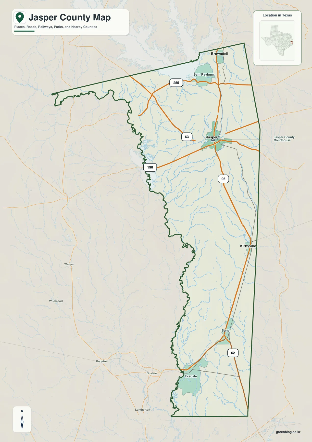
Several numbered routes provide useful orientation. Route 190 crosses through Jasper from west to east, while 96 runs south from Jasper through the eastern half of the county toward Kirbyville and Buna. The map also labels 255 in the north, 63 northwest of Jasper, and 62 near Buna. These roads do not form a simple square grid; instead, they connect a long county whose towns, river bottoms, and smaller drainage channels are spread across a large area.
The surrounding labels place Jasper County among several East Texas neighbors. Angelina County appears to the north, Tyler and Hardin counties are shown on the western side, and Newton, Sabine, and Orange counties appear to the east and southeast. Those labels are useful for regional orientation, but the county boundary map is not a parcel or property-line product. It should be used for general county geography rather than legal boundary decisions.
Jasper, Kirbyville, and Browndell as Three Clear Reference Points
The city-connection map deliberately reduces the number of labels and emphasizes three places: Jasper, Kirbyville, and Browndell. Jasper is the hub. Kirbyville is shown about 19 miles away in a straight line, while Browndell is about 14 miles from Jasper. These are direct point-to-point distances, not driving distances, so the actual road mileage and travel time can be longer.
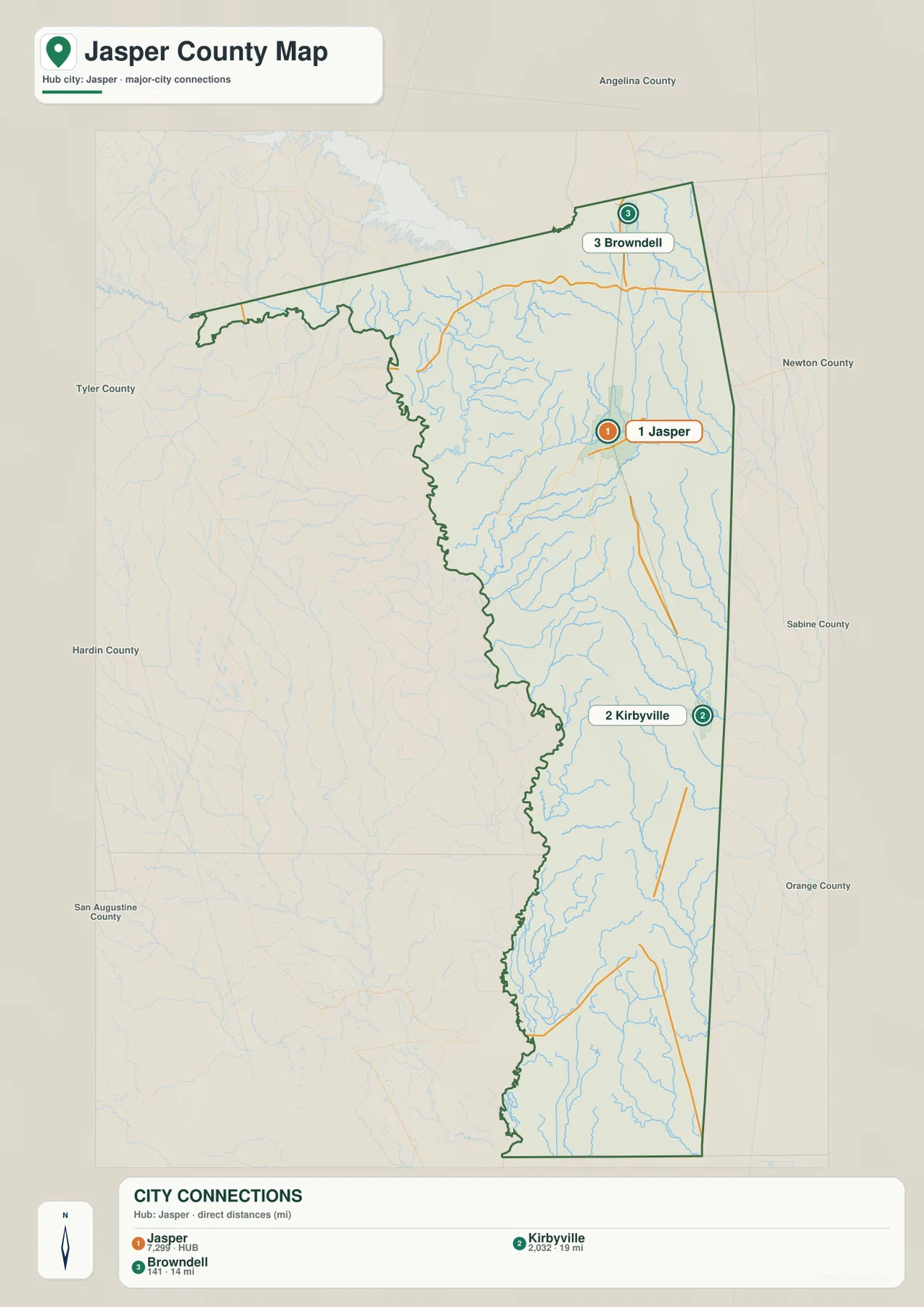
Direction matters as much as distance. Kirbyville lies southeast of Jasper, whereas Browndell is to the north. That makes the two places useful for understanding the county’s north-south span even though their listed direct distances from Jasper are relatively close. If you switch back to the full county map, Buna and Evadale extend the settlement pattern farther south and southwest, making the elongated shape even more obvious.
The city map also prints values of 7,299 beside Jasper, 2,032 beside Kirbyville, and 141 beside Browndell. The supplied package does not identify the statistical year or source for those figures, so they should be treated only as values printed on the map rather than as current population claims. For up-to-date population work, use a current official statistical source in addition to the map.
Roads from Jasper Toward Kirbyville, Buna, and the County Edges
Jasper is the easiest road reference because 190 and 96 meet there. From Jasper, 96 continues south through the eastern side of the county toward Kirbyville and then Buna. Route 190 gives Jasper a strong east-west reference, while 255 serves the northern area near Sam Rayburn and Browndell. This combination helps explain why the county map is easier to read from the center outward rather than from the boundary inward.
The smaller road network becomes more understandable once those main routes are located. Many minor roads cross or follow drainage areas that do not appear prominently on a simple road map. For a visitor looking for a community, park area, or rural address, it is therefore useful to keep both the nearest major route and the nearby creek or river in view. That is especially true away from Jasper, where labels are farther apart and the county is more rural in appearance.
Angelina River on the West and a Web of Creeks Across the County
The terrain-and-water map gives the western side of Jasper County a very different appearance from the east. The Angelina River follows the irregular western boundary, and Shelby Lake is labeled near the river. Farther east, Sandy Creek and Big Walnut Run cross the central part of the county. South of them, the map names Big Creek, Thicket Creek, Boggy Creek, Davis Creek, Trout Creek, Needle Creek, and Cypress Creek among the many smaller channels.
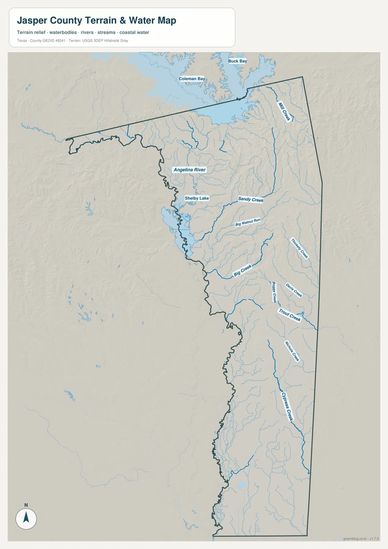
This map is useful because the small drainage channels fill spaces that look comparatively empty on the road map. The western side is dominated by the broad, winding Angelina River corridor, while the eastern and southeastern parts contain many long creeks and tributaries. That contrast helps explain why a route that appears short in a straight line may still cross several low valleys or watercourses.
The water layer is a reference map, not a flood-hazard map and not a navigation chart. It does not show legal flood zones, current water depth, bridge condition, or guaranteed public access. Anyone planning field travel near streams or river bottoms should pair it with current local and official information.
Eastern Ridges Rise Well Above the Western River Lowlands
The elevation map shows an actual range of about 2 to 177 meters, with a mean elevation of about 47 meters. The highest terrain is concentrated mainly in the northeast and along the eastern side, where orange and brown ridges stand out. Lower green terrain occupies much of the western side near the Angelina River and extends through large parts of the south.
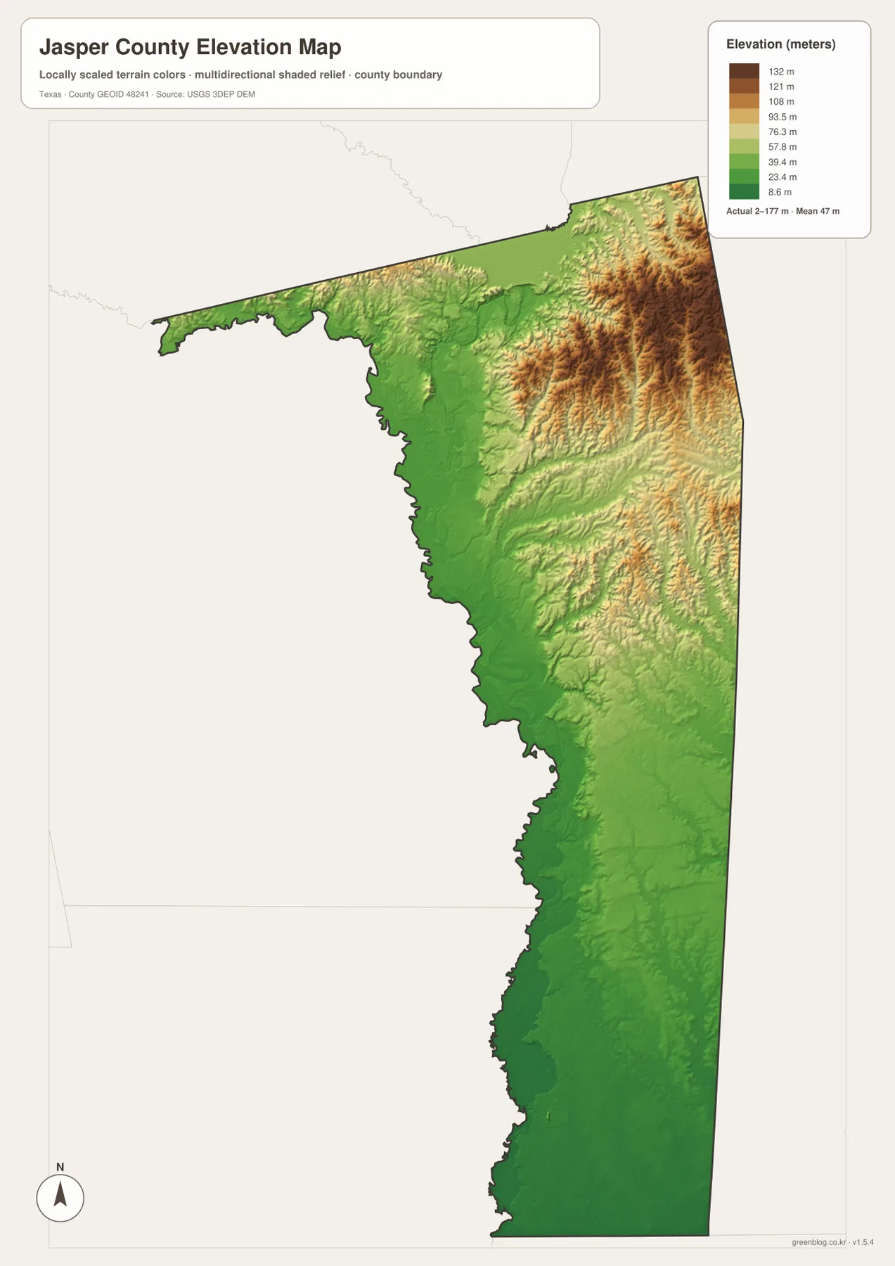
The contrast is especially clear in the northeastern quarter, where closely spaced ridges create a rougher surface than the broad low areas to the west. Smaller ridges continue down the eastern half, but the colors generally become lower toward the southwest and southern end. This is why Jasper County should not be pictured as uniformly flat even though its average elevation is modest.
The elevation image is generalized for county-scale viewing. It is helpful for comparing ridges, lowlands, and broad terrain changes, but it is not survey-grade or engineering-grade elevation data for a specific property, road, or structure. Precise work requires a more detailed elevation source or field survey.
Combining the Maps for a More Complete Jasper County View
Each map becomes more useful when paired with another. Start on the county map with Jasper and Route 96, then switch to the water map to see how many creeks cross the same corridor. Add the elevation map and the eastern side of that route can be compared with the lower Angelina River side. For a simpler location question, the city map removes most of the extra labels and makes the Jasper–Kirbyville–Browndell relationship easy to see.
For schoolwork or printed reference, the county map is the best general starting point because it keeps towns, roads, boundaries, and water lines together. The water map is better when a river or creek name matters, while the elevation map is the strongest choice for terrain comparison. The city-connection map is the most focused option when the task is simply to compare direction and straight-line distance from Jasper.
Frequently Asked Questions
What is the easiest place to locate first on a Jasper County map?
Jasper is the best starting point because Routes 190 and 96 meet there. Once Jasper is located, Browndell can be found to the north, Kirbyville to the southeast, and Buna farther south along the 96 corridor.
Are the 19-mile and 14-mile city distances driving distances?
No. The city-connection map labels approximately 19 miles from Jasper to Kirbyville and 14 miles from Jasper to Browndell as straight-line distances. Road mileage and travel time can be greater because drivers must follow the actual road network.
Which maps best show the Angelina River lowlands and the higher eastern side?
Use the terrain-and-water map to locate the Angelina River, Shelby Lake, and named creeks, then compare it with the elevation map. The elevation image shows about 2–177 meters overall, with a mean near 47 meters and the highest terrain concentrated in the east and northeast.
Sources and Reference Data
- USGS The National Map Viewer — national reference mapping for terrain, hydrography, roads, and other geographic layers.
- U.S. Census Bureau TIGER/Line Shapefiles — official boundary and transportation geography data.
- USGS National Hydrography — authoritative river, stream, lake, and water-feature data.
- USGS 3D Elevation Program — official elevation and terrain data information.
Map File Information
Download the Jasper County county map, city-connection map, terrain-and-water map, and elevation map as high-resolution JPG files.
- File Type: JPG
Related Maps
- Angelina County Texas map
- Orange County Texas map
- Sabine County Texas map
- San Augustine County
- Tyler County Texas map
Green Map creates custom-edited map images using open geographic data sources such as geoBoundaries, Natural Earth, OpenStreetMap, and government open data.
These maps are edited visual materials, not raw data files, and are provided for education, documents, presentations, and graphic reference.