Pamlico County sits in the low coastal plain of eastern North Carolina, and its map is shaped as much by water as by roads. Bayboro, the county seat, lies inland near the middle of the county, while Oriental is farther southeast on the Neuse side and Vandemere, Mesic, and Hobucken extend toward Pamlico Sound. Creeks, bays, and narrow peninsulas break up the eastern half of the county, so a simple town list does not explain how these places relate to one another.
This page provides three views of Pamlico County: a county map with roads and place names, a ranked city-distribution map, and a terrain-and-water map focused on the sound, bays, and creeks. You can download the matching high-resolution A3 JPG files together in one ZIP from the map file box below. The WebP images in the article are convenient previews, while the JPG files are the better choice for printing, enlarging, or placing in a document.
Table of Contents
Bayboro and the central road network provide the easiest starting point
On the general county map, Bayboro and Stonewall form a useful reference in the center. NC 55 runs across the western and central part of the county, linking Grantsboro and Alliance with the Bayboro–Stonewall area. That road makes the inland portion of Pamlico County comparatively easy to follow because several named communities sit along the same broad west-to-east corridor.
NC 306 adds a north–south reference on the western side. It passes the Grantsboro area and continues toward Arapahoe and Minnesott Beach near the southern edge. NC 304 is visible around Bayboro and Stonewall before continuing toward the southern interior. Oriental sits farther southeast, away from the main central cluster, which makes it clear that the county seat and the better-known waterfront community are not in the same part of the county.
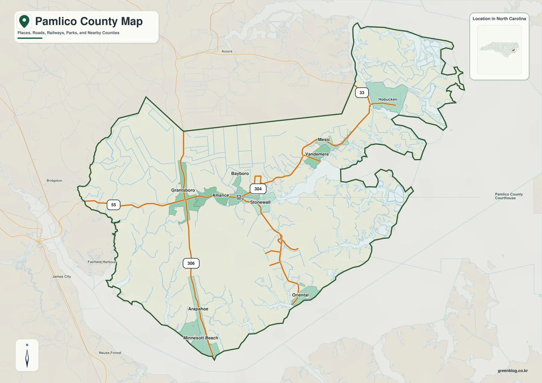
The eastern side looks very different. Vandemere and Mesic lead toward Hobucken, and NC 33 is the clearest numbered route on that long coastal extension. Roads there follow a landscape cut by creeks and bays rather than a compact grid. Nearby county names are also visible around the map, including Beaufort, Craven, Carteret, and Hyde, so the dark Pamlico County boundary is important when deciding whether a nearby label is inside or outside the county.
The city index shows several small centers instead of one dominant urban core
The city-distribution map removes most road detail and ranks six named communities. Bayboro is shown first, Oriental second, Alliance third, Grantsboro fourth, Minnesott Beach fifth, and Arapahoe sixth. The useful point is not simply the order. The map makes it obvious that the county’s recognized settlement centers are spread between the central-western area and the southern waterfront instead of forming one continuous city cluster.
Bayboro, Alliance, and Grantsboro are relatively close in the central and western part of the county. Oriental is separated to the southeast, while Minnesott Beach and Arapahoe sit farther southwest near the lower edge. This arrangement explains why Bayboro works well as an administrative reference but does not represent every part of the county equally well. A reader looking for the southern shore or the Neuse side will often get better orientation from Oriental, Minnesott Beach, or Arapahoe.
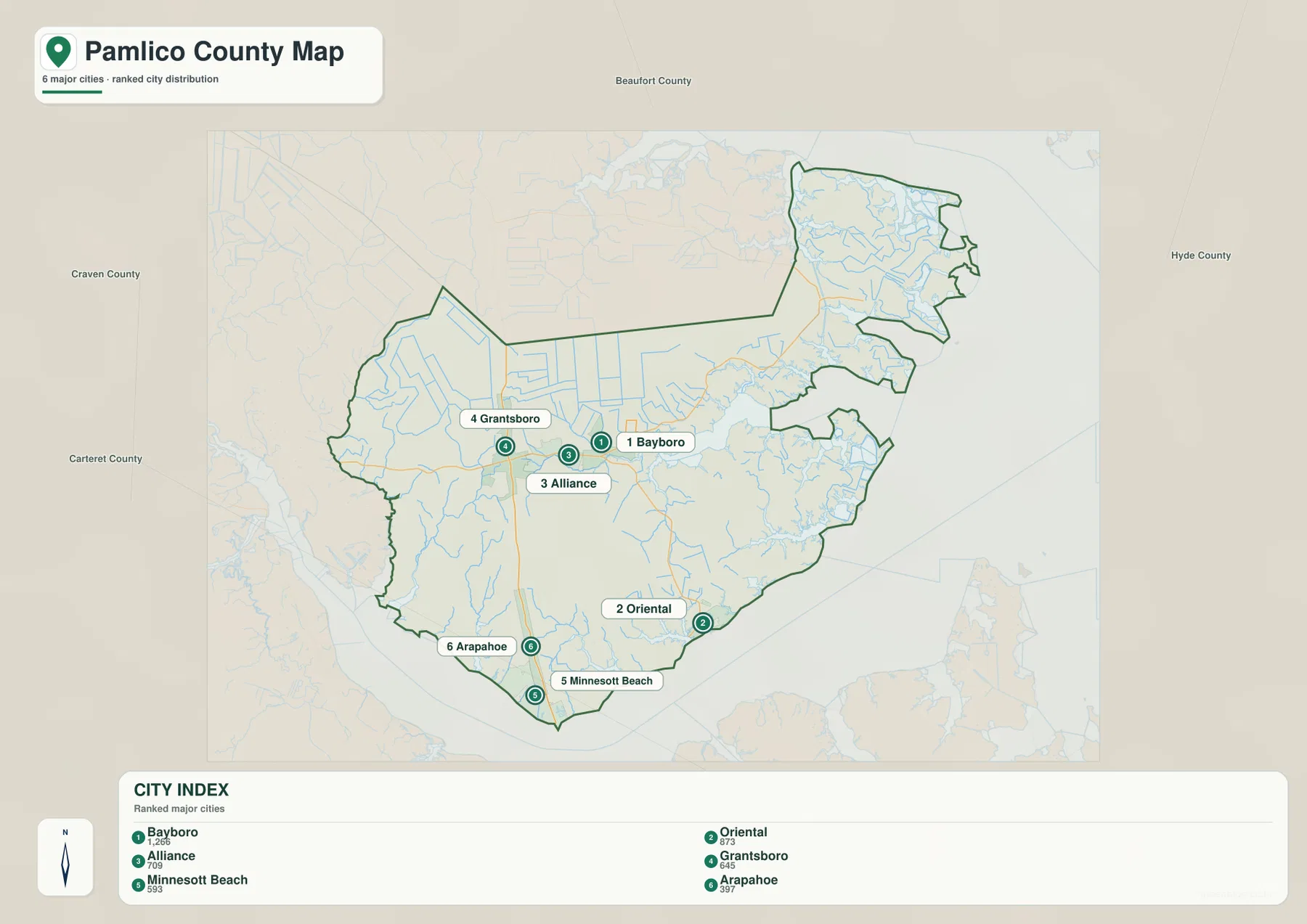
This is a location and ranking reference rather than a travel-time map. It does not show road mileage between the towns, and the numbered circles should not be treated as driving routes. Its value is the uncluttered view of where the six communities sit inside the county. Pairing it with the general road map gives a much better sense of how the central communities, the southern shore, and the southeastern waterfront relate to one another.
Pamlico Sound, bays, and branching creeks define the eastern half
The terrain-and-water map changes the emphasis completely. Pamlico Sound fills the broad water area to the east, while Mason Bay and Middle Bay reach into the county and create irregular shorelines. The southern side faces the Neuse River area, which is why Oriental is best understood as a southeastern waterfront community rather than an extension of inland Bayboro. The current county material also describes Bayboro as being on the inland Bay River system and Vandemere as oriented toward Pamlico Sound, reinforcing the fact that the county contains several different waterfront settings.
Smaller named waterways make the pattern even clearer. Whitehurst Creek, Alligator Creek, Trent Creek, Goose Creek, Beard Creek, and South Prong are all visible on the map. These streams do not form one simple straight drainage line. Instead, they branch through a low coastal landscape and enter bays or larger waters at different points, leaving narrow strips and peninsulas of land between them.
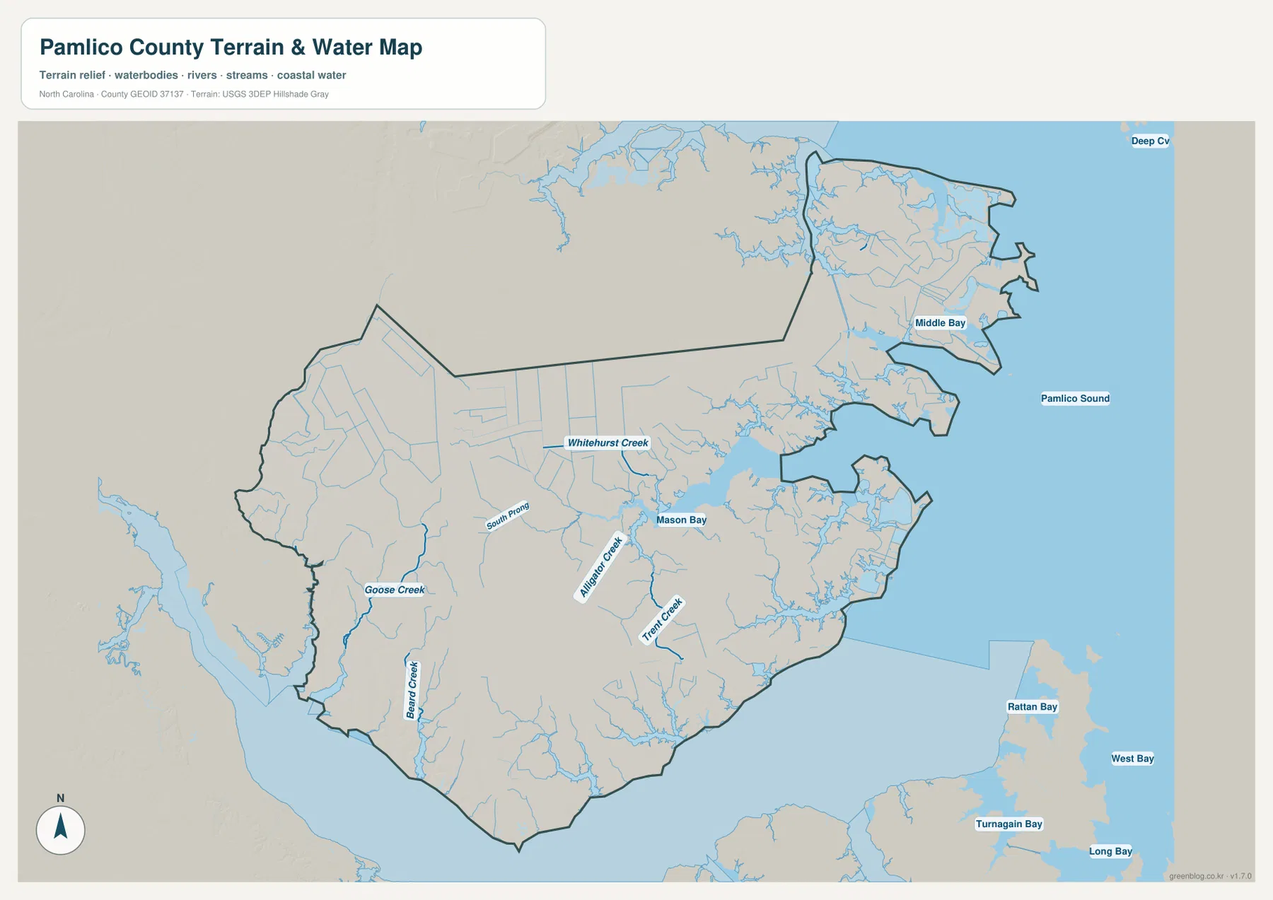
The shaded background is subtle because Pamlico County is not a mountain county. The terrain appears low and gently varied, while the water network creates most of the visual complexity. In the east and northeast, many small channels and coastal indentations produce a very irregular county outline. The western interior is broader and simpler by comparison, which is one reason the road network there is easier to understand at a glance.
This map should be used as a geographic water reference, not as a flood map, navigation chart, parcel map, or legal shoreline product. It is helpful for seeing the approximate position of creeks, bays, and Pamlico Sound and for understanding why the county boundary is so irregular. For detailed hydrography, current channel information, or technical water data, the USGS National Hydrography source linked below is the more appropriate reference.
Why Bayboro alone does not explain the county’s coastal layout
The existing county reference material notes that Pamlico County was formed in 1872 from parts of Craven and Beaufort Counties and was named for Pamlico Sound. That history fits the present map well. The western side remains connected to broader inland areas, while the eastern and southern edges are dominated by the sound, river water, bays, and creeks that create long and irregular boundaries.
Bayboro is the natural place to begin when the question is county government or a central address, but it should not become the only orientation point. Oriental gives the southeast a separate anchor on the Neuse side. Vandemere, Mesic, and Hobucken help explain the eastern extension toward Pamlico Sound. Grantsboro and Alliance describe the western-central road corridor, and Arapahoe and Minnesott Beach help locate the southwest. These places work together because each represents a different part of the county rather than a duplicate of the same center.
The road pattern supports that reading. NC 55 creates a relatively straightforward route through the central-western communities, and NC 306 leads down toward Arapahoe and Minnesott Beach. Farther east, NC 33 and smaller roads must follow land broken by creeks and bays. Two places that look close on a small-scale map may therefore require a less direct route once water and peninsula shape are considered. The water map explains why those road lines bend and separate.
Choose the map that matches the question you are trying to answer
Use the general county map when you need boundaries, named communities, and numbered roads in the same view. It is the best option for locating Bayboro, Oriental, Grantsboro, Arapahoe, Vandemere, Mesic, or Hobucken and then checking which route reaches that part of the county. The city-distribution map is cleaner when the goal is simply to compare the six ranked settlement centers without the distraction of every road and waterway.
The terrain-and-water map is the strongest choice for explaining the coastline and the county’s many creeks and bays. It shows why the eastern half cannot be understood as a simple road grid and why Pamlico Sound is only one part of a larger water network. Using all three views together gives a balanced picture: roads organize the inland communities, the city index simplifies settlement distribution, and the water map explains the unusual shape of the coast and county boundary.
The downloadable ZIP contains three high-resolution A3 JPG files matching the county map, city-distribution map, and terrain-and-water map shown in this article. They are larger than the WebP previews and are intended for printing, zoomed viewing, and document use. These maps are general geographic references, so legal boundary work, surveying, flood determinations, and navigation should still rely on the appropriate official technical data.
Frequently Asked Questions
Why should Bayboro and Oriental be treated as separate map references?
Bayboro is the inland county seat near the center, while Oriental sits farther southeast on the Neuse side. They do not occupy one continuous urban area, so Bayboro is more useful for central roads and county administration while Oriental is a better reference for the southeastern waterfront.
Does Pamlico Sound explain all of the county’s water geography?
No. Pamlico Sound is the largest named water body on the eastern side, but the map also shows Mason Bay, Middle Bay, Whitehurst Creek, Alligator Creek, Trent Creek, Goose Creek, Beard Creek, and other smaller waterways. The southern Neuse side also matters, so the county’s water setting is more varied than one sound-facing shoreline.
What files are included in the download ZIP?
The archive contains three high-resolution A3 JPG files corresponding to the general county map, the ranked city-distribution map, and the terrain-and-water map. The images shown in the article are WebP previews, so the JPG files are preferable when you need to print or enlarge the maps.
Map File Information
The ZIP contains three high-resolution A3 JPG files matching the Pamlico County map, city-distribution map, and terrain-and-water map shown on this page.
- Included Files: Use only the versions confirmed in the article and supplied images
- File Type: Use the confirmed download contents
- Intended Use: Printing, education, presentations, and map-based projects
Related Maps
Sources and References
These references support county background, boundary data, and hydrographic context. The maps on this page are designed as clear general-purpose geographic references for readers, so anyone who needs current legal boundaries or detailed technical water data should check the original agency sources as well.
Green Map creates custom-edited map images using open geographic data sources such as geoBoundaries, Natural Earth, OpenStreetMap, and government open data.
These maps are edited visual materials, not raw data files, and are provided for education, documents, presentations, and graphic reference.