Download four high-resolution JPG maps of Massac County, Illinois, in one ZIP from this page, then use the article maps to compare Metropolis, Brookport, Joppa, major roads, streams, lakes, and elevation. The Ohio River forms the county’s long southern edge, placing all three highlighted communities close to the river but in different parts of the county. Metropolis occupies the central-southern area, Joppa lies to the west, and Brookport sits farther east near the large bend of the river.
The county is small enough to read as one landscape, yet the four views reveal clear differences. Routes 45, 145, 24, and 169 organize the main settlement map. Massac Creek, Barnes Creek, Sevenmile Creek, Constant Creek, Mermet Lake, and several small southeastern lakes add a dense water network. The elevation map reports an actual range of about 90 to 179 meters and a mean near 118 meters, with low ground along the Ohio River and more rugged uplands toward the north and east.
Table of Contents
Metropolis sits between Joppa and Brookport along the Ohio River edge
The county map is easiest to read from Metropolis. Route 45 approaches from the northwest and reaches the Metropolis area near the southern edge of the county. Route 24 is labeled just east of the city and continues toward the Brookport side, while Route 145 runs north-south through the interior east of Metropolis. Route 169 appears in the northwest around Boaz. Together these roads give the county several different approaches rather than one single highway corridor.
The river communities are separated enough to have distinct map settings. Joppa is west of Metropolis along the Ohio River, while Brookport is east of Metropolis near the county’s southeastern extension. Boaz lies inland in the northwest, away from the river-side towns. Metropolis is the most prominent settlement on the map and also sits near several road connections, making it the best starting point for comparing the rest of the county.
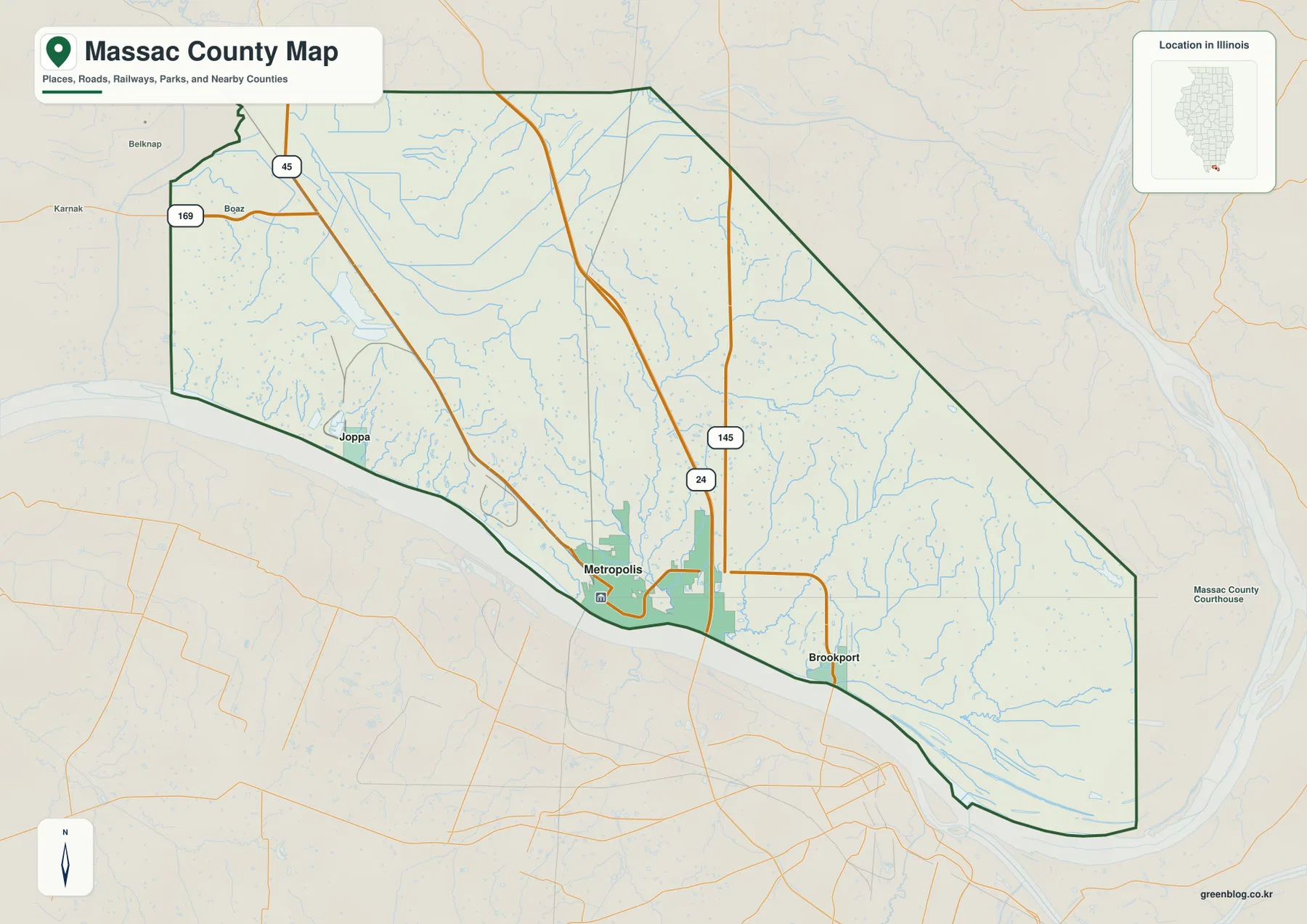
The county boundary itself reinforces the east-west difference. The north side is relatively short, while the northeastern boundary angles down toward a long southeastern section that reaches the Ohio River bend. Brookport sits within that extended eastern half, whereas Joppa belongs to the straighter western river side. This map is meant for geographic orientation rather than live navigation, so current travel times, road closures, and turn-by-turn directions should still be checked with a dedicated road service.
Three highlighted communities and their straight-line distance from Metropolis
The city map reduces Massac County to three highlighted places and uses Metropolis as the hub. Its index lists Metropolis at 5,864, Brookport at 733, and Joppa at 259. Brookport is shown about 6 miles from Metropolis and Joppa about 7 miles from Metropolis. Those figures are straight-line distances between the mapped locations, not driving distances along roads.
That simple distance view makes the river-side arrangement easy to understand. Brookport is east of Metropolis, while Joppa is west, so the two smaller communities lie in nearly opposite directions from the hub. The distance numbers are similar, but the surrounding terrain and road access are not identical. Brookport is close to the southeastern river bend and Route 24 area, whereas Joppa sits on the western river side closer to the Route 45 corridor.
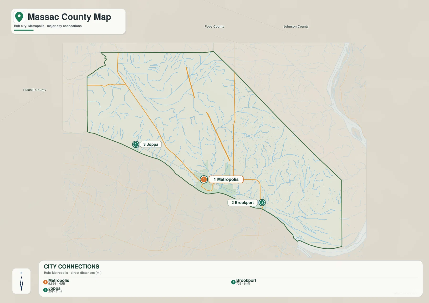
For settlement comparison, the city map is intentionally simpler than the general county map. It omits Boaz and most road labels so the three main places remain easy to locate. Once the relative positions are clear, the county map adds the road network and boundary shape. This two-step approach is useful because the distance view answers a different question from the road map instead of repeating the same labels.
Ohio River lowlands fed by Massac Creek and a web of eastern streams
The terrain and water map begins with the Ohio River, which follows the southern county boundary and makes a broad bend around the southeast. Several small lakes sit near that lower river environment, including Loon Lake, Kinneman Lake, and Beaverdam Lake. The concentration of channels and low ground near the southeastern edge gives that part of the county a noticeably different water pattern from the hillier interior.
Massac Creek is the main named stream through the central part of the county. It runs generally south toward the Ohio River and is joined by a network of smaller channels. Barnes Creek occupies the eastern interior, while Sevenmile Creek and Constant Creek follow long valleys farther southeast. In the western half, Mermet Lake is a major labeled water body. Cagle Pond appears in the north, and New Columbia Ditch, Bear Creek Ditch, and Big Bay Ditch are labeled across the north-central area.
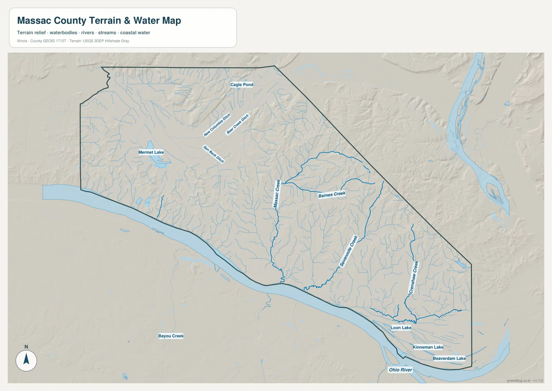
This map is a geographic water reference, not a flood-risk map, parcel or legal-boundary product, navigation chart, or drainage-engineering document. Its main value is showing how the named streams fit into the county’s terrain. When compared with the elevation map, Massac Creek, Barnes Creek, Sevenmile Creek, and Constant Creek occupy lower corridors between higher ridges, while the Ohio River follows the broadest low area.
From 90 m river lowlands to 179 m ridges in the north and east
The elevation map reports an actual range of about 90 to 179 meters and a mean near 118 meters. The lowest green terrain follows the Ohio River and spreads across much of the southern part of Massac County. Metropolis and Brookport sit close to this low river environment. Broad green areas also occupy much of the center and west, including the Mermet Lake side of the county.
The strongest relief appears toward the north and across the eastern half. Narrow brown and tan ridges rise in the north-central area, while the eastern interior contains repeated hills cut by stream valleys. Around Barnes Creek and Sevenmile Creek, higher ridges and lower green channels alternate closely. Near the southeastern Ohio River bend, the land drops again into low ground, creating a clear transition from rugged interior terrain to the river margin.
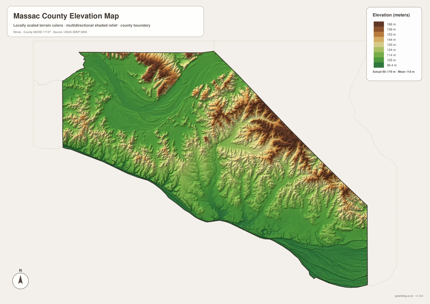
The elevation surface is generalized for county-scale comparison and should not be treated as survey-grade height, parcel elevation, or engineering data. For ordinary map reading, however, it explains the water map well. The central and eastern creeks follow lower valleys, while the higher ridges sit between them. The county map then adds Metropolis, Brookport, Joppa, and the road network, showing how settlement and transportation fit within that terrain.
Use Metropolis as the reference point, then switch maps by question
Start with the county map when roads, the full boundary, and the positions of Metropolis, Brookport, Joppa, and Boaz matter most. Use the city map when the main question is how Brookport and Joppa compare with Metropolis in position and straight-line distance. The terrain and water map is the clearest view for the Ohio River, Massac Creek, Barnes Creek, Mermet Lake, and the southeastern lakes. The elevation map explains why the river side is low and why the northern and eastern interior looks more rugged.
Metropolis is a useful place to follow across all four views. The county map shows its road connections and river-side position. The city map makes it the hub for Brookport and Joppa. The water map places the city beside the Ohio River and downstream from the central creek system, while the elevation map shows the broad low ground along the southern edge. Brookport can be read in the same way, beginning with its 6-mile straight-line distance from Metropolis and ending with the low southeastern river bend.
Frequently Asked Questions
How far are Brookport and Joppa from Metropolis on the city map?
The city map shows Brookport about 6 miles from Metropolis and Joppa about 7 miles from Metropolis. These are straight-line distances between the mapped locations, not driving distances. Brookport lies east of the hub and Joppa lies west, so the two smaller communities sit in nearly opposite directions along the Ohio River side of the county.
Where is the highest terrain in Massac County?
The elevation map places the strongest high ground in the north and eastern interior, where tan and brown ridges are cut by creek valleys. The Ohio River edge around Metropolis and Brookport is much lower. Barnes Creek and Sevenmile Creek provide good examples of streams running through lower corridors between higher ridges.
What files are included in the downloadable ZIP?
The ZIP contains four high-resolution JPG files: the county and road map, city-connections map, terrain and water map, and elevation map. Each image is 3638 × 2572 pixels. Smaller WebP versions are used in the article for faster viewing, while the JPG files are better for close inspection and print. The water and elevation maps are general geographic references rather than flood, legal-boundary, survey, or engineering products.
Map File Information
Download the Massac County county map, city-connections map, terrain and water map, and elevation map together as high-resolution JPG files.
- Included Files: Use only the versions confirmed in the article and supplied images
- File Type: Use the confirmed download contents
- Intended Use: Printing, education, presentations, and map-based projects
Related Maps
Sources and references
- U.S. Census Bureau TIGER/Line Shapefiles – county boundaries, roads, and place reference
- USGS National Hydrography – Ohio River, streams, lakes, and other hydrography reference
- USGS 3D Elevation Program – elevation and terrain reference
- Massac County Illinois official website – official county information for Metropolis, Brookport, and Joppa
- Illinois DNR – Fort Massac State Park – official information about Fort Massac State Park and the Ohio River setting at Metropolis
Green Map creates custom-edited map images using open geographic data sources such as geoBoundaries, Natural Earth, OpenStreetMap, and government open data.
These maps are edited visual materials, not raw data files, and are provided for education, documents, presentations, and graphic reference.