Surry County lies along North Carolina’s northern edge, where foothill terrain meets the Piedmont below the Virginia line. Mount Airy is the largest visible urban area in the north, while Dobson is a much smaller county seat near the middle. Elkin sits in the southwest close to the Yadkin River, and Pilot Mountain provides a separate eastern settlement and terrain reference. Those four places make the county easier to understand than a Dobson-only description.
This page includes a general road-and-place map, a city-connections map centered on Mount Airy, and a terrain-and-water map showing the Yadkin, Fisher, Ararat, and Mitchell river systems. The WebP images are designed for quick viewing on the page. A ZIP with the matching high-resolution A3 JPG files is available in the map file box below for printing, close inspection, or use in a document.
Table of Contents
Four reference points make the county easier to understand
- County seat: Dobson
- Largest northern city reference: Mount Airy
- Southwestern town and river reference: Elkin and Yadkin River
- Eastern reference: Pilot Mountain
- Road numbers visible on the general map include 74, 52, 89, 103, 104, 21, 77, 268, and 601
- Named waterways include Yadkin River, Fisher River, Little Fisher River, Ararat River, Mitchell River, and Jones Creek
The county-specific land-use material preserved in the package treats the Yadkin corridor, mountain ridges, and stream basins as important parts of Surry County’s landscape. The existing page also states that the county was created from Rowan County in 1771. Those background points are retained here, but the main discussion stays with features that can be located on the supplied maps.
Mount Airy, Dobson, and Elkin play very different map roles
Mount Airy is the dominant urban reference on the general map. Route 52 passes south of the city toward Pilot Mountain, while route 74 approaches the Mount Airy area from the west. Toast and Flat Rock are labeled close to the city, so the northern section reads as a broader cluster of named places rather than a single isolated point.
Dobson is much smaller and sits south of Mount Airy near the middle of the county. Its importance comes from the county-seat role rather than from being the largest settlement. Route 601 provides a useful north-south reference through the central area, and Dobson’s position makes it a practical midpoint when comparing Mount Airy in the north with Elkin in the southwest.
Elkin occupies the lower-left corner close to the Yadkin River side of the county. Routes 21 and 268 are visible near the town, and Jonesville appears just outside the boundary as regional context. Elkin therefore works best as a southwestern river-corridor reference, not as a smaller copy of Dobson’s central administrative role.
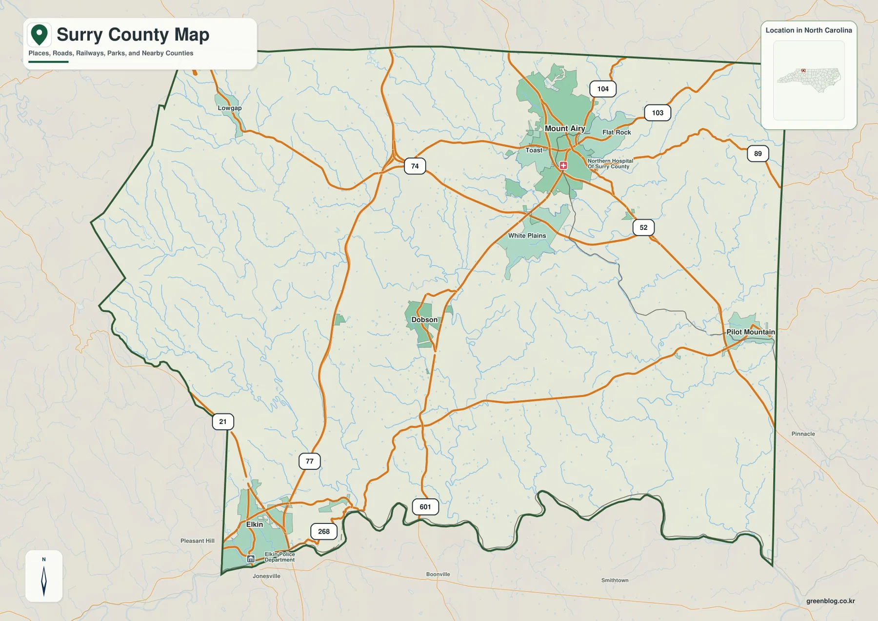
Pilot Mountain is separated from the central towns on the eastern side. Route 52 provides the clearest large road connection back toward Mount Airy, while route 89 appears farther northeast and routes 103 and 104 are visible around the northern city. Taken together, the general map shows a county with several directional centers rather than one settlement controlling every road and outer area.
Yadkin River and the Fisher-Ararat systems explain the spaces between towns
Yadkin River is the strongest large-water reference along the southern edge. It bends across the lower boundary near the Elkin side and continues eastward, making the shape of the county easier to understand than it is on the road map alone. The southwestern town and the river are closely associated on the map, while Dobson and Mount Airy sit farther inland.
Fisher River and Little Fisher River run through the central-western interior as separate but nearby channels. Mitchell River appears farther southwest and reaches toward the Yadkin side. These rivers turn the broad space between Mount Airy, Dobson, and Elkin into a landscape of repeated valleys rather than an empty rural block.
Ararat River provides the strongest named water reference on the eastern half of the terrain map. It descends from the north and continues toward the southern part of the county, while Jones Creek is labeled near the far-eastern side. That separation is useful because it shows that Surry County’s interior drainage is divided among several river systems rather than organized around one central channel.
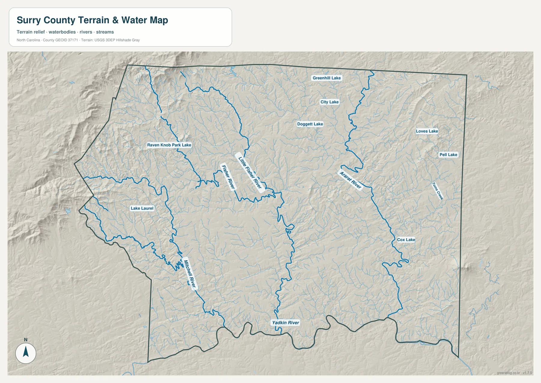
Named lakes provide smaller local references. Greenhill Lake is shown in the north, with City Lake and Doggett Lake farther south. Loves Lake and Pelli Lake appear on the eastern side, Cox Lake is farther southeast, and Lake Laurel plus Raven Knob Park Lake provide western references. None of these small water bodies defines the county by itself, but they help distinguish individual valleys and outer areas.
Foothill relief becomes stronger toward the north and west
The terrain shading is rougher in the northern and western parts of the county than along much of the southern edge. Ridges and valleys are closely packed below the Virginia line and west of Mount Airy, while the landscape becomes gentler toward Dobson and the Yadkin River side. That visual transition supports the existing description of Surry County as a Piedmont-to-mountain junction.
Mount Airy is a large northern city, but the surrounding landscape is not flat. Numerous small streams descend from the higher ground, and the Fisher River system continues toward the center. Elkin occupies a different setting close to the Yadkin River in the southwest, so the two towns represent contrasting parts of the same county even before their city sizes are compared.
Pilot Mountain and the Ararat River side provide another distinct eastern setting. The general map shows the town as an eastern settlement, while the terrain map adds ridges and a separate river corridor around it. Reading both views together prevents the county from being simplified into a northern city and a southern river only.
The shaded map is meant for general terrain orientation rather than engineering work. It shows relative ridge-and-valley structure and the location of rivers and streams, but it does not provide survey-grade elevations, flood determinations, parcel boundaries, or navigation information. Those tasks require the official Census, USGS, or county source data.
Mount Airy hub distances show how far the main places are separated
The city-connections map uses Mount Airy as the hub and prints four values in its lower panel: Mount Airy 10,633, Elkin 4,043, Dobson 1,652, and Pilot Mountain 1,483. These are values displayed on the supplied graphic. This article does not present them as independently updated population estimates.
The same map gives straight-line distances from Mount Airy of about 10 miles to Dobson, 12 miles to Pilot Mountain, and 21 miles to Elkin. These are not driving distances or travel times. Elkin lies far to the southwest and Pilot Mountain to the southeast, so actual road routes should be checked on the general map rather than inferred from the connector lines.
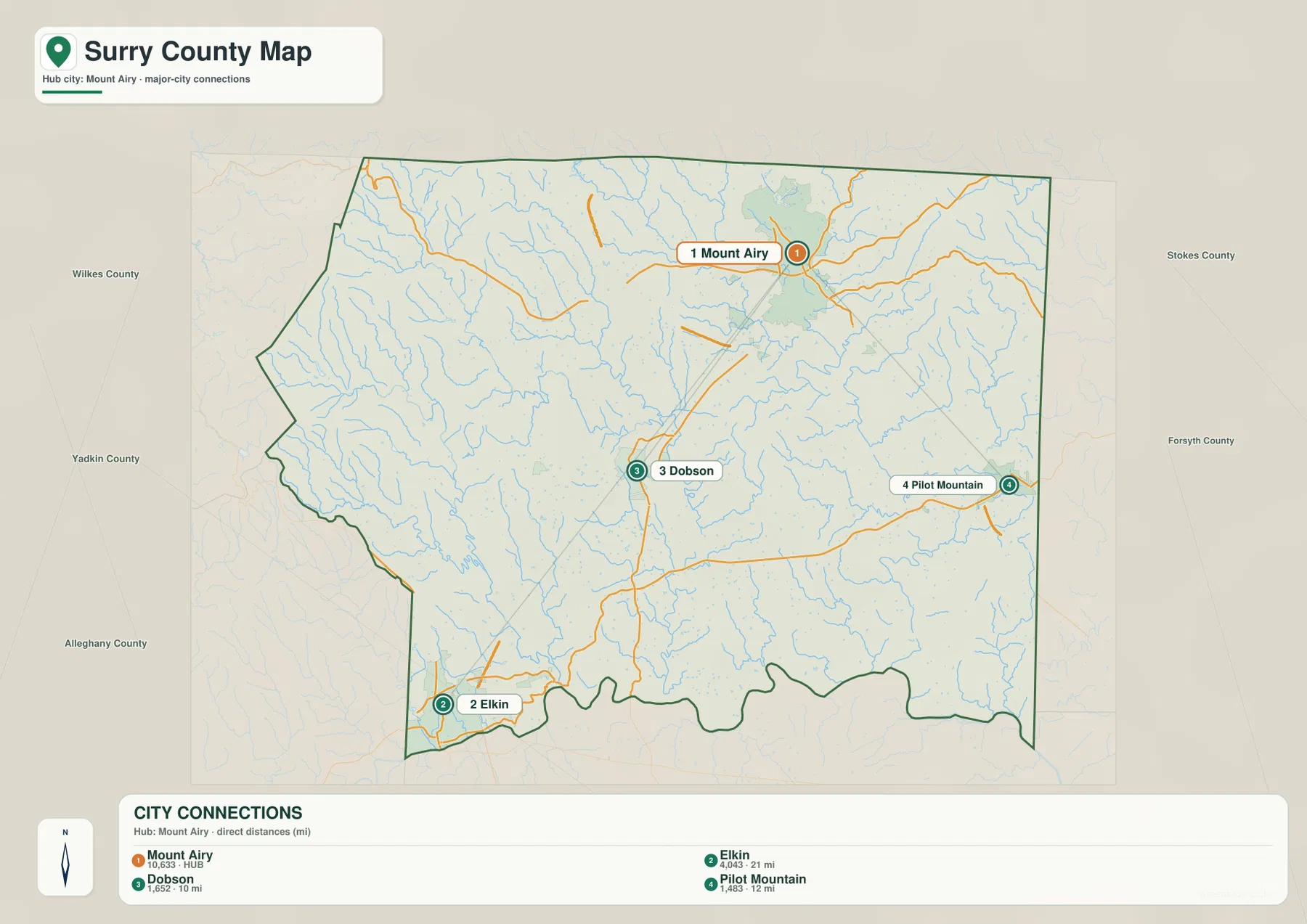
Use the city-connections view when the main question is how the four places are positioned relative to Mount Airy. The general map is better when road numbers and smaller place labels matter, while the terrain-and-water map is the stronger choice for Yadkin River, Fisher River, Ararat River, and the ridge-and-valley pattern between the towns. Switching views keeps administrative role, settlement size, route direction, and physical geography from being mixed together.
The download archive contains three high-resolution A3 JPG files matching the Surry County general map, city-connections map, and terrain-and-water map. The WebP versions are convenient for quick browsing, while the JPG originals are better for enlargement, printing, and document placement. Each file emphasizes a different part of the county, so readers can choose the version that matches the information they need.
Frequently Asked Questions
Why is Yadkin River a stronger physical anchor than a simple place-name list?
Yadkin River explains the southwestern and southern physical setting around Elkin in a way that town names alone cannot. Read together with Dobson and Mount Airy, it separates the river-side lowlands from the more inland and foothill parts of the county.
What geographic contrast appears when Mount Airy and Dobson are read together?
Mount Airy is the larger northern urban center, while Dobson is a much smaller county seat near the middle. Keeping both visible separates administrative importance from settlement size and also makes the approximately 10-mile straight-line connection on the city map more meaningful.
Map File Information
The ZIP contains three high-resolution A3 JPG files matching the Surry County general map, city-connections map, and terrain-and-water map shown on this page.
- Included Files: 3 high-resolution A3 JPG maps described on this page
- File Type: JPG files in a ZIP archive
- Intended Use: Printing, education, presentations, and map-based projects
Related Maps
Sources
- Surry County Land Use Plan
- U.S. Census Bureau – TIGER/Line Shapefiles
- USGS – National Hydrography
- USGS – 3D Elevation Program
These sources provide county background, boundary and road information, hydrographic context, and elevation-source data. The settlement values, straight-line distances, road numbers, rivers, streams, and lake names described above are grounded in the supplied Surry County package, without adding unsupported technical measurements.
Green Map creates custom-edited map images using open geographic data sources such as geoBoundaries, Natural Earth, OpenStreetMap, and government open data.
These maps are edited visual materials, not raw data files, and are provided for education, documents, presentations, and graphic reference.