Swain County is a mountain county where water and relief occupy far more visual space than towns. Bryson City is the county seat and the only ranked major city on the supplied city map, but the general map also gives Cherokee a clear eastern position and Fontana Lake dominates the western physical landscape. Reading only the county seat would hide most of what makes this map different from a flatter, more urban county.
This page uses three map views. The general county map is best for Bryson City, Cherokee, Fontana Dam, road numbers, and the county outline. The city map deliberately stays simple because it ranks only Bryson City. The terrain-and-water map carries much of the geographic detail, showing Fontana Lake, the Tuckasegee, Oconaluftee, Nantahala, and Little Tennessee rivers, plus many narrow mountain streams. A ZIP containing the matching high-resolution A3 JPG files is available in the map file box below, while the WebP images are designed for quick on-page viewing.
Table of Contents
Swain County is organized more by valleys and water than by a network of cities
- County seat and only ranked major city on the supplied city map: Bryson City
- Other visible general-map references include Cherokee, Fontana Dam, and Three Forks
- Road labels visible on the general map include 441, 28, 129, 19, and 74
- City Index: Bryson City 1,902
- Major water references: Fontana Lake, Tuckasegee River, Oconaluftee River, Nantahala River, Little Tennessee River
- Mountain streams labeled on the terrain map include Big Creek, Hazel Creek, Forney Creek, Noland Creek, Indian Creek, Raven Fork, Straight Fork Creek, and Alarka Creek
The existing page material in the package states that Swain County was formed in 1871 from parts of Jackson and Macon counties. It also describes Great Smoky Mountains National Park and the Cherokee area as occupying important parts of the county, and identifies the Nantahala, Tuckasegee, Oconaluftee, and Little Tennessee rivers as major water systems associated with Fontana Lake. Those county-specific points are retained as background, while the detailed descriptions below stay close to what is visible on the supplied maps.
Bryson City and Cherokee occupy different mountain corridors
Bryson City appears in the south-central part of the general map, where several roads converge within a narrow valley. The surrounding county remains largely mountainous, so the town does not visually dominate the same amount of land that a county seat might in a flatter region. Following the map east brings Cherokee into view as a separate labeled area rather than as part of the Bryson City urban footprint.
Route 441 is the strongest numbered-road reference around the Cherokee side. It continues northward through the mountain section and gives the eastern county a different directional structure from the roads around Bryson City. Keeping Cherokee as its own reference point makes the map easier to read because the eastern valleys no longer have to be described as generic outskirts of the county seat.
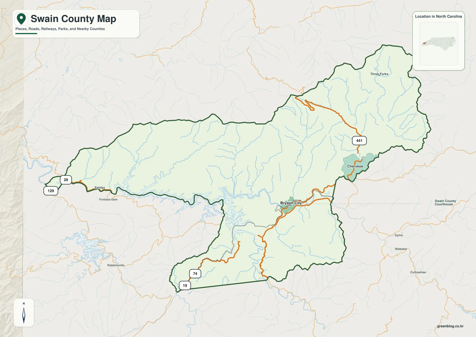
The west changes character again. Fontana Dam is labeled near the western side, with routes 28 and 129 providing useful road references close to that edge. Routes 19 and 74 appear near the southwestern portion of the map. This side contains far more lake shoreline and rugged terrain than developed settlement, so a road-only description does not fully explain the western county.
Three Forks appears as a small place label in the northeast, but the broader area is still dominated by ridges and streams. Outside labels such as Sylva, Webster, Cullowhee, and Robbinsville provide regional orientation only. The dark Swain County boundary should be checked first so those surrounding places are not confused with locations inside the county.
Fontana Lake and Tuckasegee River define the central-western landscape
Fontana Lake is the most prominent water body on the terrain map. Its shoreline reaches into narrow mountain valleys, creating a highly irregular pattern across the central-western part of the county. The road map can make this area look like a broad stretch of sparsely labeled mountain land, while the water map reveals long inlets, tributary valleys, and a much more divided physical landscape.
Tuckasegee River is the strongest river reference near Bryson City. It runs through the central valley and continues toward Fontana Lake, giving the county seat a clear physical setting. Bryson City therefore makes more sense as a valley town tied to the river than as a simple dot at the center of the county.
Hazel Creek, Forney Creek, and Noland Creek descend through separate western mountain valleys toward the Fontana Lake system. Their names are most useful when connected to the lake rather than listed as isolated streams. Together they help explain why the northern and western shoreline is broken into so many narrow arms and why travel across the outer county cannot be understood from straight-line distance alone.
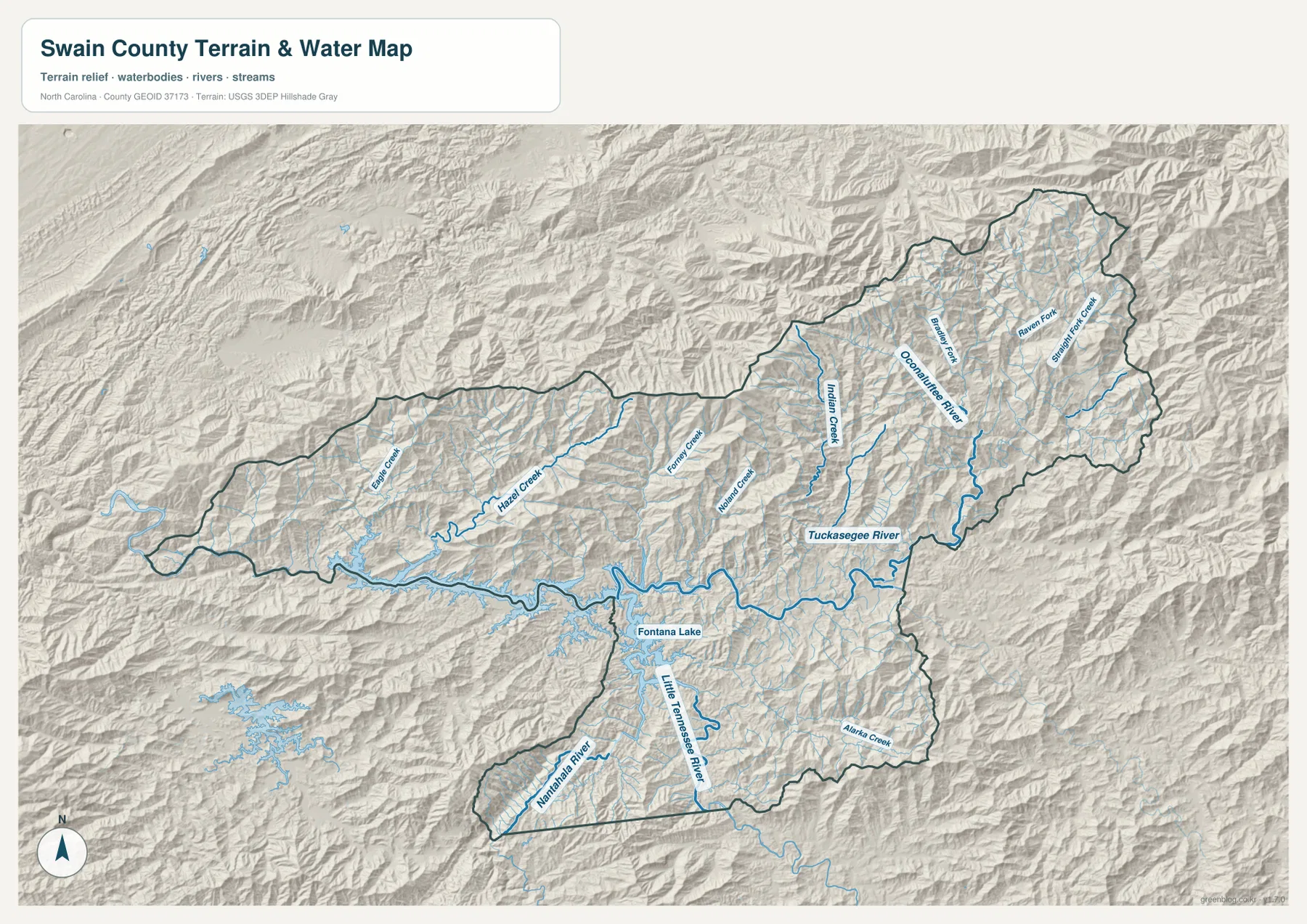
The southwest contains another set of major water references. Nantahala River and Little Tennessee River are labeled in this part of the map, while Alarka Creek appears farther east within the southern section. Indian Creek is closer to the central-eastern Tuckasegee side. These separate channels show that Swain County is not drained by one simple valley; ridges repeatedly divide the county into different river and creek corridors.
Oconaluftee River gives the Cherokee side its own physical frame
Oconaluftee River is the clearest large-water reference on the eastern side of the terrain map. It descends through the northeastern mountain section toward the Cherokee direction, with several smaller streams branching through nearby valleys. The river gives the east a natural frame that is different from the Tuckasegee valley around Bryson City.
Big Creek, Raven Fork, and Straight Fork Creek appear in the eastern and northeastern mountain area. Rather than treating these as a list of stream names, it is more useful to see how they break the high-relief terrain into multiple narrow valleys. That pattern helps explain why road access and settlement placement are constrained by the shape of the mountains.
The city map is especially revealing because it ranks only one major city: Bryson City, with a City Index value of 1,902. Cherokee and Fontana Dam are not forced into the city ranking. This is an important limitation to preserve rather than ‘fix,’ because the map is telling the reader that Swain County cannot be described through a six-town hierarchy like many other county pages.
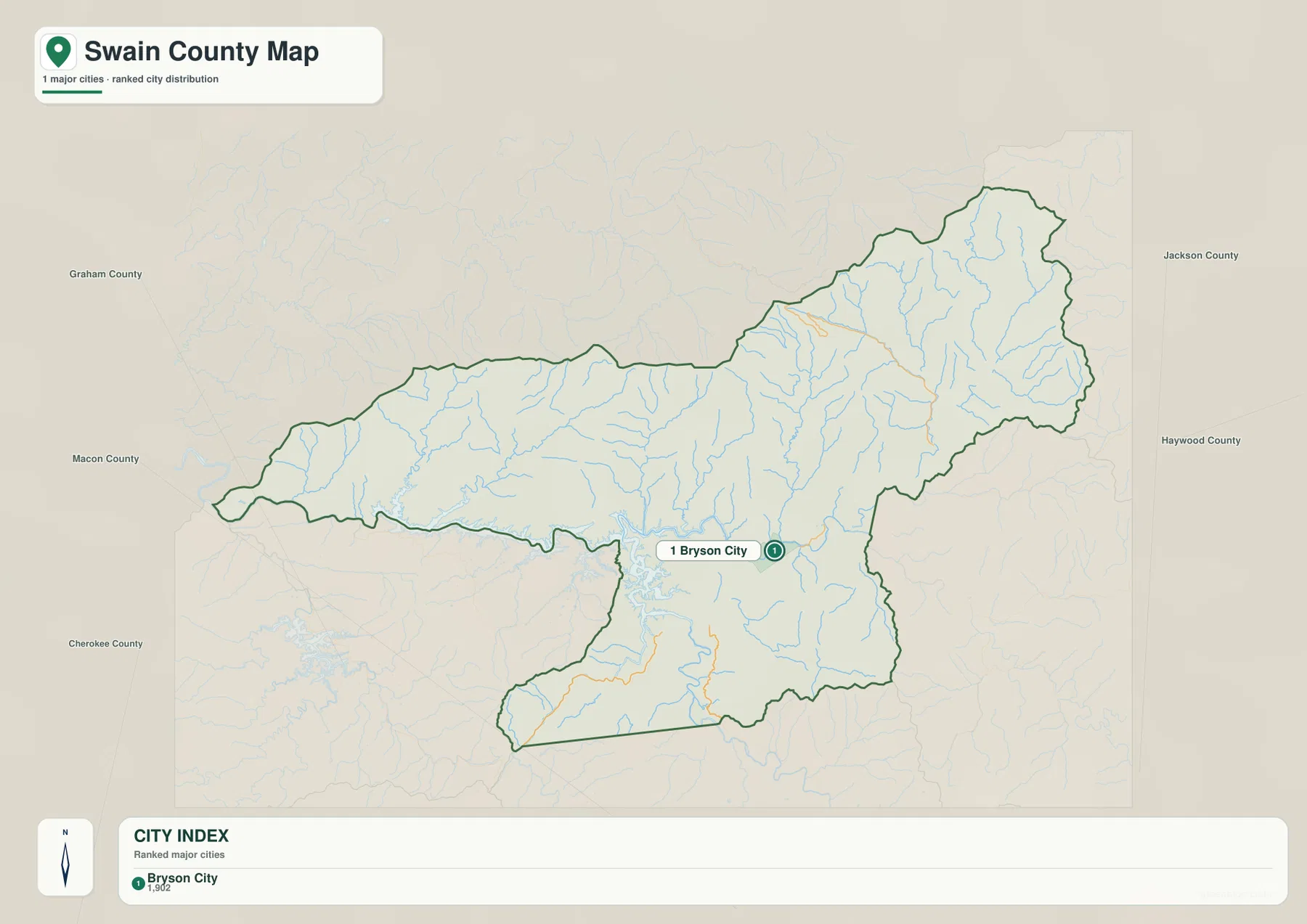
That one-city result makes the other map types more important. Cherokee remains a meaningful general-map reference, Fontana Lake dominates the west, and the large protected mountain areas described in the existing page material occupy much more space than urban development. A useful Swain County article therefore has to shift between settlement, river, lake, and mountain references instead of trying to manufacture additional city comparisons.
Choose the map by valley, road, or water question
Use the general map when the main question is where Bryson City, Cherokee, Fontana Dam, or the numbered roads are located. Route 441 helps with the Cherokee and northeastern direction, routes 28 and 129 help orient the western edge, and routes 19 and 74 provide southwestern references. In a mountain county, this road view is more useful for travel orientation than a simple straight-line city comparison.
Use the city map when you need the simplest possible picture of settlement concentration. It confirms that Bryson City is the only ranked major city in this package. Instead of stretching that graphic beyond its purpose, move back to the general map for Cherokee and Fontana Dam or to the terrain map for the broader county.
Use the terrain-and-water map for the physical geography that actually fills most of Swain County. Fontana Lake and Tuckasegee River are strong central-western anchors, Oconaluftee River and Raven Fork help explain the east, and Nantahala plus Little Tennessee River give the southwest its own river references. The hillshade makes ridge-and-valley differences visible, but it should not be interpreted as precise elevation measurements.
The download archive contains three high-resolution A3 JPG files matching the Swain County general map, city map, and terrain-and-water map. The WebP versions are convenient for browsing, while the JPG originals are better for printing, enlargement, and document placement. Legal boundary decisions, surveying, flood determinations, navigation, and engineering-grade elevation work should rely on the appropriate official Census, USGS, or county data rather than these general reference maps.
Frequently Asked Questions
Why is Fontana Lake essential for understanding the western side of Swain County?
The general map leaves much of the west sparsely labeled, but the terrain map shows Fontana Lake extending into multiple mountain valleys with Hazel, Forney, and Noland creeks nearby. The lake provides a much clearer physical reference for the outer county than Bryson City alone.
Why should Cherokee remain separate from Bryson City in the map description?
Bryson City is the county seat in the Tuckasegee River valley, while Cherokee sits farther east where the Oconaluftee River and route 441 provide stronger local references. Keeping the two places separate preserves the real difference between the central administrative valley and the eastern mountain area.
Map File Information
The ZIP contains three high-resolution A3 JPG files matching the Swain County general map, city map, and terrain-and-water map shown on this page.
- Included Files: 3 high-resolution A3 JPG maps: general county, city, and terrain/water
- File Type: JPG files in a ZIP archive
- Intended Use: Printing, education, presentations, and map-based projects
Related Maps
- Across the Rowan County North Carolina Map
- Across the Surry County North Carolina Map
- Alamance County Map
Sources
- Swain County Government – Administration
- U.S. Census Bureau – TIGER/Line Shapefiles
- USGS – National Hydrography
- USGS – 3D Elevation Program
These references provide county administrative background plus boundary, road, hydrography, and elevation-source information. The place names, road labels, City Index value, rivers, creeks, and lake descriptions in this article are grounded in the supplied Swain County package and its existing page material, without adding unsupported technical measurements.
Green Map creates custom-edited map images using open geographic data sources such as geoBoundaries, Natural Earth, OpenStreetMap, and government open data.
These maps are edited visual materials, not raw data files, and are provided for education, documents, presentations, and graphic reference.