Transylvania County sits in the southern Blue Ridge, where mountain ridges, river headwaters, and forested valleys occupy far more space than towns. Brevard is the county seat and the largest ranked community, but Rosman in the southwest represents a different upper-valley setting. The general map also shows that roads bend through narrow terrain rather than forming a simple grid, so a town-only description would miss most of the county’s geography.
This page uses three complementary views: a general county map for Brevard, road numbers, and mountain access; a city-distribution map that ranks only Brevard and Rosman; and a terrain-and-water map showing the French Broad headwaters, Davidson River, several forks, small lakes, and strong relief. The WebP images are meant for quick viewing in the article. A ZIP with the matching high-resolution A3 JPG files can be downloaded from the map file box below for printing, enlargement, or document use.
Table of Contents
Brevard and Rosman provide two settlement anchors in a much larger mountain landscape
- County seat and largest ranked community: Brevard
- Ranked city map: Brevard 7,897; Rosman 699
- Road labels visible on the general map include 280, 64, 215, 276, 178, and 281
- Visible access references include Courthouse Falls Trailhead and Devils Courthouse
- Named waterways include French Broad River, Davidson River, North Fork French Broad River, West Fork French Broad River, East Fork French Broad River, and South Fork Mills River
- Named small water bodies include Cascade Lake, Dupont Lake, Ticoa Lake, Atagahi Lake, Lake Wanteska, Lake Arrowhead, Lora Young Lake, and Frozen Lake
The existing county material describes Transylvania as the Land of Waterfalls and cites about 250 waterfalls, with Pisgah National Forest, Gorges State Park, and DuPont State Forest among the major natural areas. It also states that the county was formed from parts of Henderson and Jackson counties in 1861. Those points are useful background, while the detailed road, settlement, and water descriptions below stay with features visible in the supplied map set.
Brevard’s road network opens into several very different mountain directions
Brevard lies a little east of the center of the county and is the clearest place to start on the general map. Route 280 leaves toward the northeast, route 276 runs toward the southeastern edge, and route 64 provides an important cross-county reference. Route 215 leads into the western mountain interior. Together these roads show Brevard as a valley junction rather than a flat central grid.
The northwest quickly becomes more about mountain access than settlement. Courthouse Falls Trailhead and Devils Courthouse MP 422.4 are labeled in this part of the general map, where route lines bend through steep terrain. Those references help separate the forest-and-ridge side of the county from the everyday road pattern around Brevard.
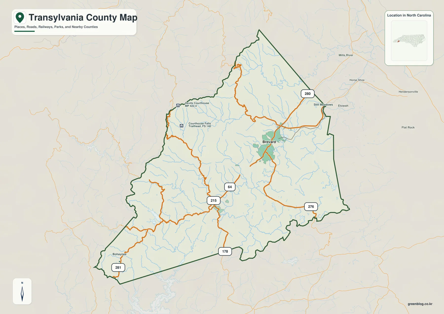
South and southwest of Brevard, the road network becomes sparse again. Route 178 heads toward the southern boundary and route 281 appears near the far southwestern corner. In this area, the roads follow valleys rather than forming direct straight connections, which is one reason Rosman should be read together with the headwater map instead of treated as a nearby suburb of Brevard.
Outside the county, Hendersonville, Flat Rock, and Etowah appear as regional references. They are not Transylvania County places. The dark county outline matters on the eastern side because the boundary bends through mountain terrain and waterways rather than following a simple rectangular shape.
French Broad headwaters split into several forks before the river leaves the county
French Broad River is the strongest large-water name on the terrain map, but the upper basin is not a single channel. The map shows several forks running through separate mountain valleys before they contribute to the broader river system. This makes the physical organization around Brevard and Rosman much clearer than the road map alone.
North Fork French Broad River and West Fork French Broad River occupy separate central-western and southwestern valleys. East Fork French Broad River appears farther south. Rosman sits close to this upper-basin setting, so the town is more useful as a headwater-valley reference than as merely the second name on a two-city ranking.
Davidson River runs through the northeastern interior and provides a separate valley reference near the forest side of Brevard. South Fork Mills River appears in the north. These waterways make the northern and northeastern county legible even where town labels are sparse, and they show that the county’s internal direction is strongly controlled by ridge-and-valley drainage.
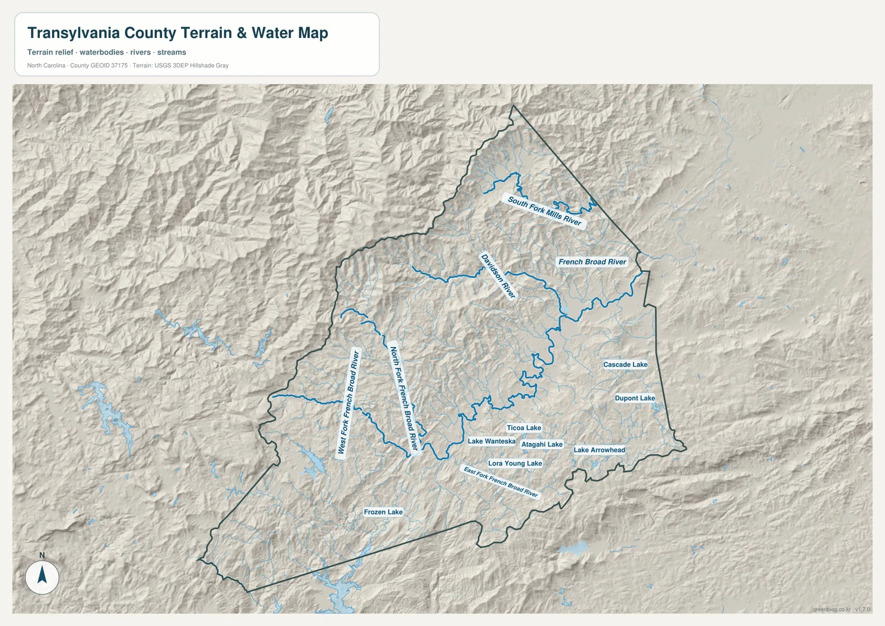
Small lakes provide more detailed local references in the southeast and interior. Cascade Lake and Dupont Lake sit toward the eastern side, while Ticoa Lake, Atagahi Lake, Lake Wanteska, Lake Arrowhead, and Lora Young Lake cluster through southern and southeastern valleys. Frozen Lake appears farther southwest. Their distribution reinforces the fact that water is spread through many separate mountain basins rather than one single lowland corridor.
The relief shading is rugged across nearly the whole county. Tight ridges and valleys repeat from west to east, with rivers and creeks following the lower ground. This map is useful for general terrain orientation, but it is not a survey-grade elevation product, flood map, parcel map, or navigation chart.
A two-city ranking is a feature of the map, not a gap to fill
The city-distribution map ranks only two major communities. Brevard is first at 7,897 and Rosman is second at 699. Those are values printed on the supplied graphic; this article does not present them as independently updated population estimates.
Brevard occupies the larger central-eastern settlement area, while Rosman sits well to the southwest in a different valley. The separation matters more than the ranking alone. Brevard is associated with the county’s main road junctions, whereas Rosman is closer to the upper French Broad forks and the 178 corridor.
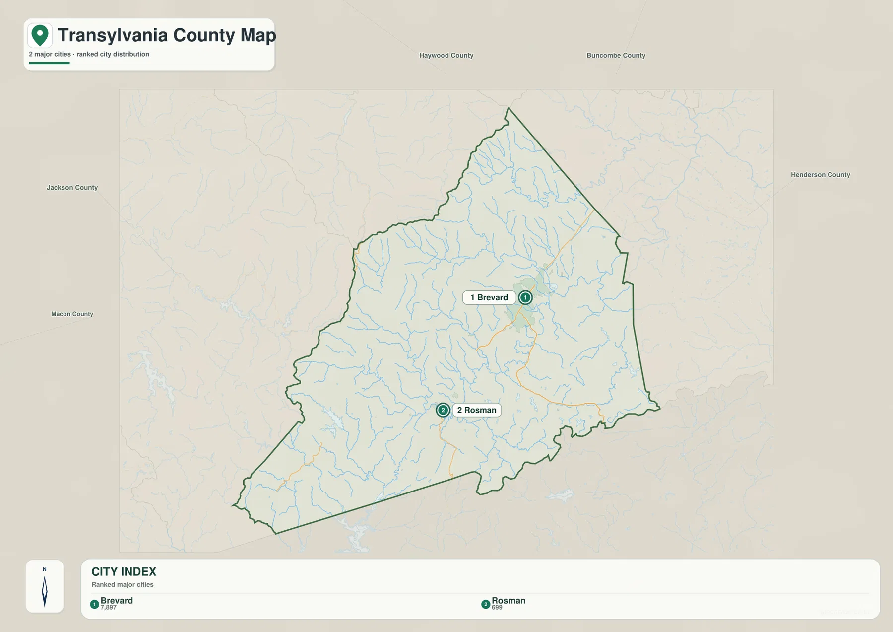
County labels outside the map include Haywood, Buncombe, Henderson, Jackson, and Macon. They help locate Transylvania County within western North Carolina but are only regional context. The city map is not intended to measure legal adjacency or travel distance, so the county outline and the two internal ranked places remain the important references.
Keeping the city map limited to two ranked places is especially appropriate here. The existing county material emphasizes waterfalls, national forest, parks, and headwaters because those features occupy far more of the county than urban development. Adding invented city comparisons would make the page less accurate, not more complete.
Waterfalls, forest, roads, and towns should remain separate layers of the same county story
The best map depends on the question. Use the general map for Brevard, numbered roads, and mountain access points such as Courthouse Falls Trailhead. Use the city map when you only need the Brevard-Rosman settlement comparison. Use the terrain-and-water map when the focus is French Broad headwaters, Davidson River, small lakes, or the ridge-and-valley pattern.
The county source’s ‘about 250 waterfalls’ description is valuable context, but this map set does not mark every waterfall individually. It is more accurate to use that figure as county background while relying on the supplied map for features actually shown, such as Courthouse Falls Trailhead, named rivers, roads, and lakes. The same principle applies to Pisgah National Forest, Gorges State Park, and DuPont State Forest: they help explain the county’s identity without turning this page into a complete park-boundary map.
The download archive contains three high-resolution A3 JPG files matching the Transylvania County general map, city-distribution map, and terrain-and-water map. The WebP versions are convenient for quick browsing, while the JPG originals are better for printing, enlargement, and document placement. Each file emphasizes a different part of the county, so readers can choose roads, settlement distribution, or water-and-relief detail as needed.
These are general geographic reference maps. Legal boundary decisions, surveying, flood determinations, navigation, and engineering-grade elevation work should rely on the appropriate official Census, USGS, or county source data rather than this downloadable map set.
Frequently Asked Questions
How do the French Broad headwaters clarify the difference between Brevard and Rosman?
Brevard is the larger road and service center, while Rosman sits farther southwest near several upper French Broad forks. Reading the towns together with the river system separates the main county center from a smaller headwater-valley community.
Why does a county known for waterfalls have only a few waterfall references on these maps?
The county source describes about 250 waterfalls, but this package contains general county, city, and terrain-and-water maps rather than a dedicated waterfall inventory. Courthouse Falls Trailhead is one visible example, while the broader waterfall identity is best treated as county background.
Map File Information
The ZIP contains three high-resolution A3 JPG files matching the Transylvania County general map, city-distribution map, and terrain-and-water map shown on this page.
- Included Files: 3 high-resolution A3 JPG map files shown in this article
- File Type: JPG files in a ZIP archive
- Intended Use: Printing, education, presentations, and map-based projects
Related Maps
- Across the Rowan County North Carolina Map
- Across the Surry County North Carolina Map
- Alamance County Map
Sources
- Transylvania County – About Our County
- U.S. Census Bureau – TIGER/Line Shapefiles
- USGS – National Hydrography
- USGS – 3D Elevation Program
For this Transylvania County page, the linked sources cover county background, boundary and road data, hydrography, and elevation-source information. The city values, road numbers, rivers, forks, lakes, and access-point labels described above are grounded in the supplied package, while the waterfall and protected-land context stays within the scope of the county material already attached to the page.
Green Map creates custom-edited map images using open geographic data sources such as geoBoundaries, Natural Earth, OpenStreetMap, and government open data.
These maps are edited visual materials, not raw data files, and are provided for education, documents, presentations, and graphic reference.