Tyrrell County on North Carolina’s northeastern Coastal Plain is a place where water and lowland drainage matter more than an urban hierarchy. Columbia is the county seat and the only ranked major city on the supplied city map, but Albemarle Sound, Scuppernong River, and Alligator River explain much more of the county’s shape. Away from Columbia, the maps quickly become dominated by creeks, straight drainage lines, swamps, bays, and broad wet lowlands rather than by additional town centers.
The page provides three complementary views. The general map is useful for Columbia, Woodley, Kilkenny, Lewis Point, and routes 64 and 94. The city map intentionally ranks only Columbia. The terrain-and-water map carries much of the geographic detail, showing Albemarle Sound, Scuppernong River, Alligator River, several creeks and forks, Hollow Ground Swamp, Goose Pond, The Straits, and Babbitt Bay. The matching high-resolution A3 JPG files are available together in the ZIP download box below, while the WebP images are intended for quick on-page viewing.
Table of Contents
Tyrrell County quick facts
- County seat and only ranked major city on the supplied city map: Columbia
- City Index value printed for Columbia: 759
- Other place labels visible on the general map include Woodley, Lewis Point, and Kilkenny
- Primary numbered-road references visible on the general map: 64 and 94
- Major water references: Albemarle Sound, Scuppernong River, Alligator River
- Smaller water and lowland references include Riders Creek, 2nd Creek, Juniper Creek, Northwest Fork, Southwest Fork, Hollow Ground Swamp, Goose Pond, The Straits, and Babbitt Bay
The existing page material also uses Gum Neck and Fort Landing as small settlement references beyond Columbia and describes pocosin wetlands as an important part of the county’s low-density setting. Those terms are retained as background rather than being forced into the ranked city map. The rewrite gives priority to the features that are actually visible in the supplied maps and uses the older page context only where it helps explain the broader wetland-rural landscape.
Sound, river, and swamp dominate the map
The general map starts with Columbia, but it quickly shows why a town-first description is not enough. Route 64 approaches from the west through the Woodley side and reaches the Columbia area. Route 94 rises from the southern Kilkenny direction. These roads provide useful orientation, yet much of the space between them is filled by water channels and long straight drainage features instead of dense streets or large developed areas.
North of the central road network, Albemarle Sound becomes a much stronger physical reference. Scuppernong River enters the northern-central part of the county and provides a natural anchor close to Columbia. Farther east and southeast, road density drops while broad water margins and wet lowlands take over the map. That change makes the county easier to read by water system than by trying to invent a chain of towns that the city map does not contain.
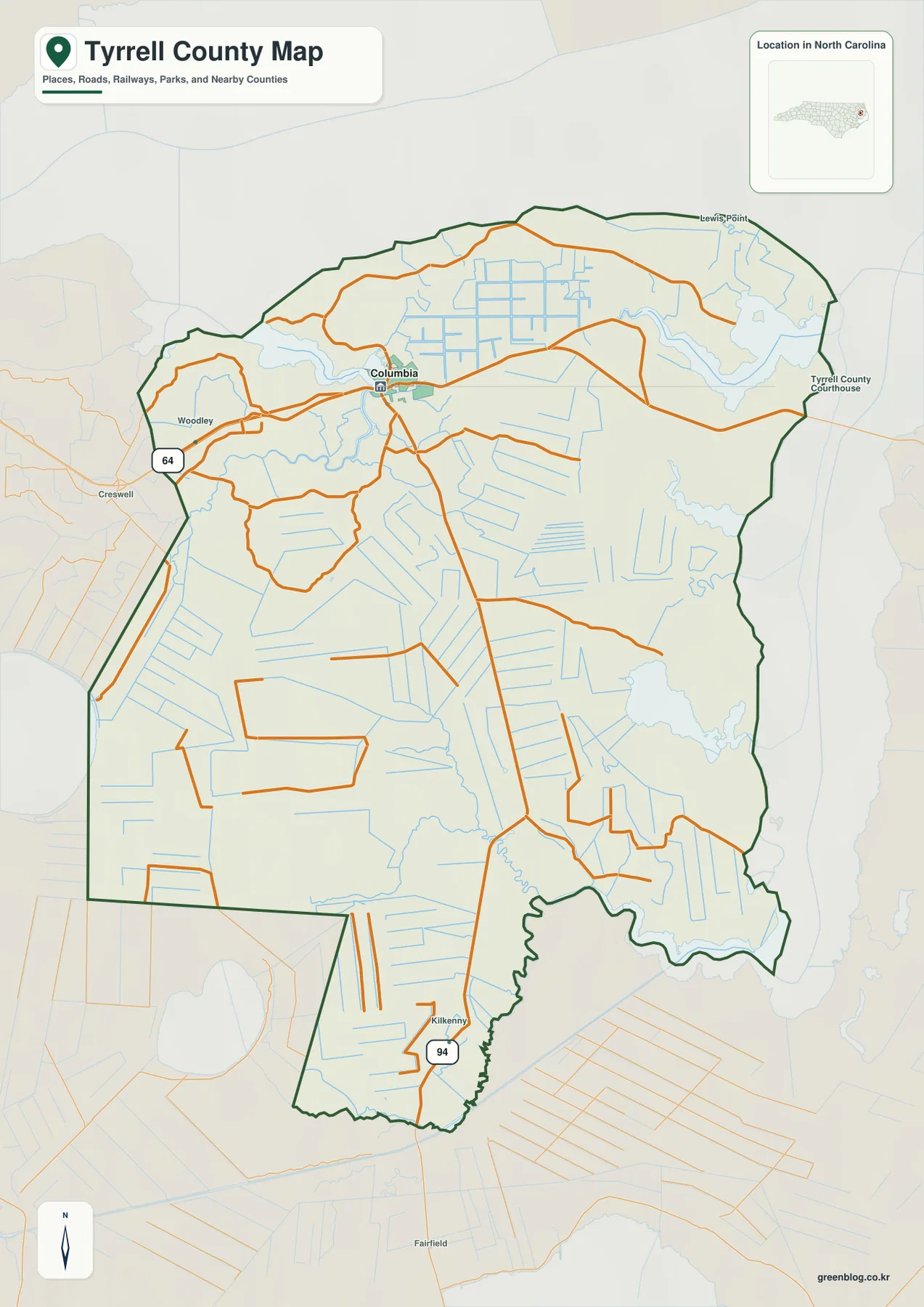
Lewis Point appears as a small northeastern place label, while Kilkenny marks a southern road reference close to route 94. Neither should be treated as a major urban center. Their value is geographic: they help divide the county into local directions where road labels alone would otherwise be sparse.
Outside labels such as Creswell and surrounding county names provide regional context only. Tyrrell County’s outline bends around water and wetland edges, so the county boundary and the larger water references should be checked before assuming that every nearby label belongs inside the county.
Columbia plus two tiny rural settlements
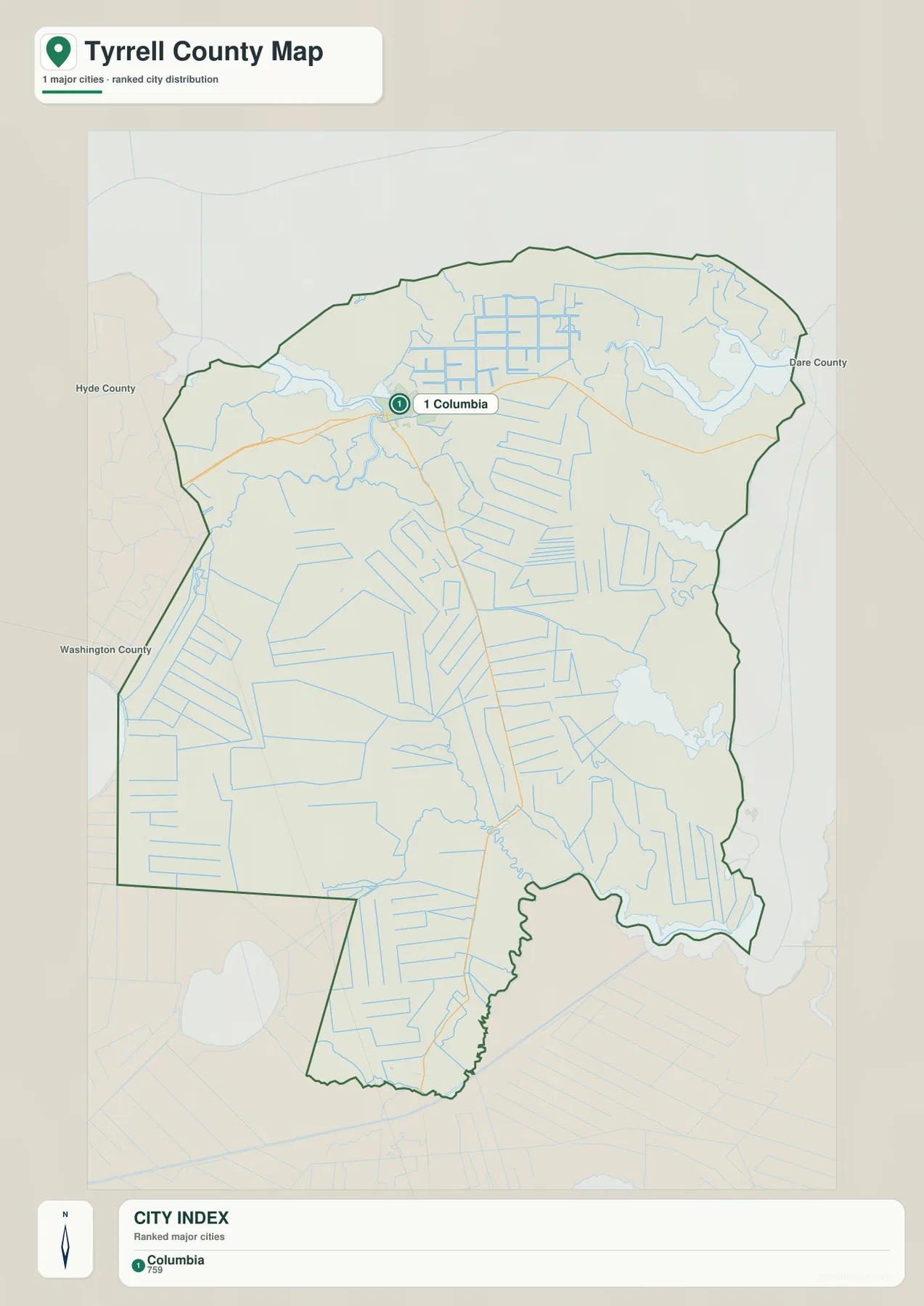
The city-distribution map is deliberately sparse. It ranks only Columbia and prints a City Index value of 759. That one-city result is not a defect to fill with invented comparisons; it is useful evidence that Tyrrell County does not have the same urban hierarchy as larger county pages. The article therefore keeps the city graphic simple and moves to other map types for the outer county.
Columbia sits near the northern-central part of the county and is the clearest administrative and road reference. Route 64 approaches from the west, while roads from the south converge around the same area. Once the map moves away from Columbia, named settlement areas become much less common, and waterways and drainage features take over the visual structure.
The existing page material refers to Gum Neck and Fort Landing as small settlement anchors. They are not ranked on the supplied city graphic, so this rewrite does not present them as equivalent to Columbia. Instead, they remain background references for understanding a county where small communities are spread through a much larger wetland-rural landscape.
The city map also labels Hyde County, Washington County, and Dare County outside the Tyrrell boundary. Those names help position the county within northeastern North Carolina. They should be used for regional orientation rather than as legal measurements of adjacency or distance.
Pocosin land limits development
The existing article describes pocosin wetlands and coastal lowlands as important constraints on the county’s settlement pattern. The supplied water map does not label one large area simply as ‘Pocosin,’ so this page does not invent a boundary for it. What the map does show clearly is a broad flat county crossed by many creeks, canals, forks, swamps, and straight drainage lines. That visible structure provides the right context for the older pocosin description.
Scuppernong River is the strongest northern river reference. Riders Creek and 2nd Creek branch nearby, while canal labels appear closer to the western side. Just outside the compact Columbia road network, the map shifts into a drainage-dominated landscape where water lines repeatedly cross the low terrain.
Farther south, Juniper Creek leads toward a separate set of lowland channels. Northwest Fork and Southwest Fork divide the interior before the map reaches Hollow Ground Swamp near the lower boundary. Rather than reading those names as a direction-by-direction checklist, it is more useful to see them as evidence that several separate wet corridors divide the county south of Columbia.
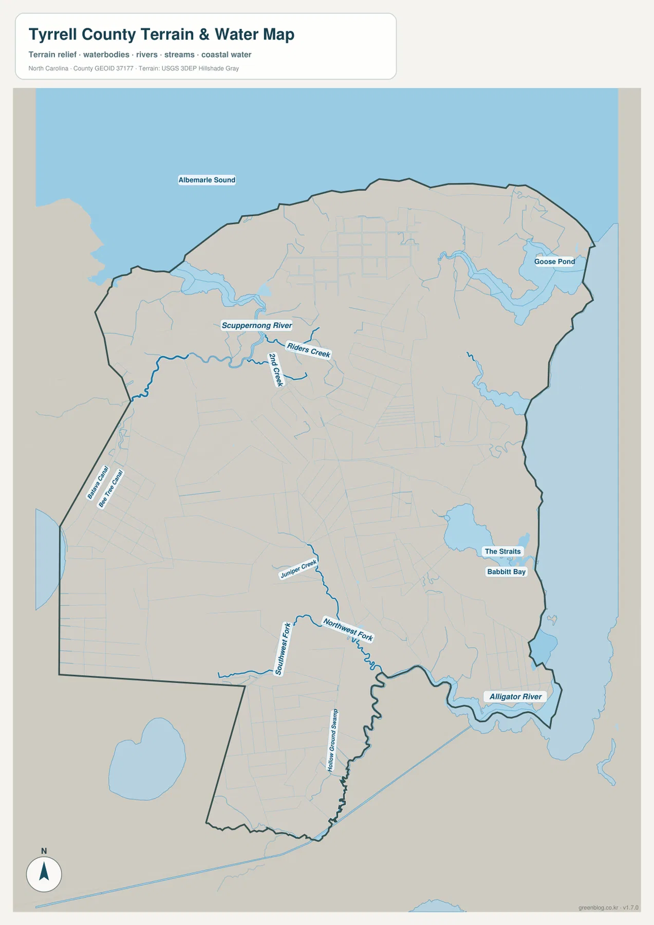
The eastern side adds more distinct water references. Goose Pond is labeled in the northeast, while The Straits and Babbitt Bay appear in the east-central portion. Alligator River defines the strongest large-water reference along the southeastern edge. These features do not radiate from Columbia; they organize separate parts of the county by shoreline, swamp, creek, and river.
Relief shading is subdued compared with a mountain county. The important visual pattern is broad low terrain interrupted by water, swamp, and drainage infrastructure. This terrain-and-water map is a general geographic reference, not a flood-hazard map, navigation chart, parcel survey, or engineering drainage model.
Reading an ultra-low-density county by natural zones
A practical way to read Tyrrell County is to keep Columbia as the administrative anchor but let the water systems define the outer county. Albemarle Sound and Scuppernong River organize the north, the eastern bays and channels organize the middle-east, and Alligator River plus the lower forks and swamp references organize the southeast and south. This approach is more faithful to the supplied map than describing every area as an outer suburb of Columbia.
Use the general map when Columbia, Woodley, Kilkenny, route 64, or route 94 is the main question. Use the city map when you need to confirm that Columbia is the only ranked major city in this package. For the spaces between those road and settlement references, the terrain-and-water map is far more informative because it shows the rivers, creeks, forks, swamps, bays, and broad wet margins that dominate the county.
Gum Neck, Fort Landing, and the older pocosin framing can still be useful, but they should remain clearly distinguished from what the supplied preview maps directly show. Gum Neck and Fort Landing are background settlement references from the existing page rather than ranked city points here, and pocosin is a county-landscape concept rather than a newly drawn legal or ecological boundary in this map set.
The download archive contains three high-resolution A3 JPG files matching the Tyrrell County general map, city map, and terrain-and-water map. The WebP previews are convenient for browsing, while the JPG originals are better for enlargement, printing, and document placement. Legal boundaries, surveying, flood determinations, navigation, and technical drainage work should rely on the appropriate Census, USGS, or other official source data rather than these general reference maps.
Frequently Asked Questions
Why should Albemarle Sound remain a separate map reference?
Albemarle Sound represents part of the county’s physical framework; Columbia, Gum Neck, and Fort Landing represent settlement. The two layers should remain distinct so urban or administrative importance does not erase terrain or water context.
What does Gum Neck contribute to the county’s settlement pattern?
Gum Neck extends the map beyond a seat-centered description. It provides another settlement anchor for reading areas that would otherwise be represented only through Columbia.
Map File Information
The ZIP contains three high-resolution A3 JPG files matching the Tyrrell County general map, city map, and terrain-and-water map shown on this page.
- Included Files: 3 high-resolution A3 JPG map files shown in this article
- File Type: JPG files in a ZIP archive
- Intended Use: Printing, education, presentations, and map-based projects
Related Maps
- Across the Rowan County North Carolina Map
- Across the Surry County North Carolina Map
- Alamance County Map
Sources
- NCpedia – Tyrrell County
- U.S. Census Bureau – TIGER/Line Shapefiles
- USGS – National Hydrography
- USGS – 3D Elevation Program
These references provide county background plus boundary, road, hydrography, and elevation-source information. The Columbia value, visible place labels, and named rivers, creeks, forks, bays, and swamps described above are grounded in the supplied Tyrrell County package. Gum Neck, Fort Landing, and pocosin context are kept within the scope of the existing page rather than expanded with unsupported detail.
Green Map creates custom-edited map images using open geographic data sources such as geoBoundaries, Natural Earth, OpenStreetMap, and government open data.
These maps are edited visual materials, not raw data files, and are provided for education, documents, presentations, and graphic reference.