This Lake County Florida Map is built around a landscape where water strongly shapes cities, roads, and county travel. Tavares sits among the central lakes, with Leesburg, Eustis, and Mount Dora nearby, while Clermont, Minneola, and Groveland form a separate cluster farther south. The page explains the county boundary, city pattern, major roads, and waterways shown in the supplied maps. A downloadable ZIP containing the county, city, and water maps as high-resolution A3 JPG files is also provided below.
Table of Contents
A county organized around lakes rather than one urban center
Lake County is easy to misunderstand if it is viewed only as part of Central Florida. Its central communities are not arranged around one continuous urban core. Instead, broad lakes break the settled area into distinct waterfront and near-water towns. Tavares lies between Lake Dora and Lake Eustis, Eustis stands to the northeast, Mount Dora sits on the eastern side of Lake Dora, and Leesburg is farther west between the Lake Harris and Lake Griffin area. Their closeness on a regional map can hide the fact that water often determines the practical route from one place to another.
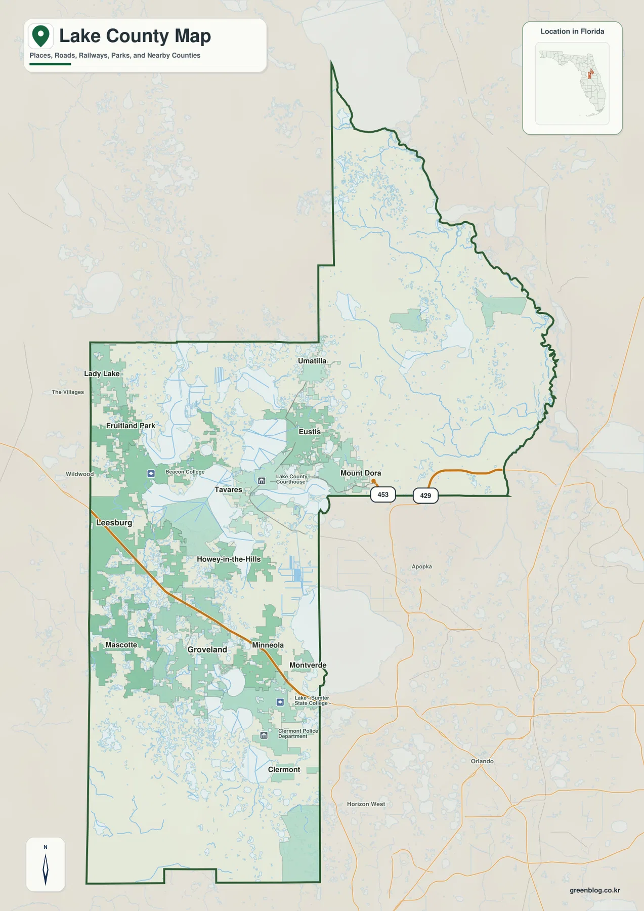
The county outline is also unusually varied. Sumter County is to the west, Marion County lies to the north, and Volusia, Seminole, and Orange counties are on the eastern side. Polk County borders the south. Lake County extends a long distance into the northeast, creating a narrow northern section that feels much more rural than the central lake district or the southern Clermont area. This shape is useful to keep in mind when estimating travel across the county, because a short straight-line distance can translate into a much longer road trip.
Tavares and the central lake cities
Tavares is the county seat and works well as a reference point for the central part of Lake County. It is close to Eustis and Mount Dora, while Leesburg lies farther west. These communities are separated by large bodies of water but remain closely linked by highways. Lady Lake and Fruitland Park are farther northwest near the Sumter and Marion county sides, while Umatilla is positioned northeast of the main central cluster.
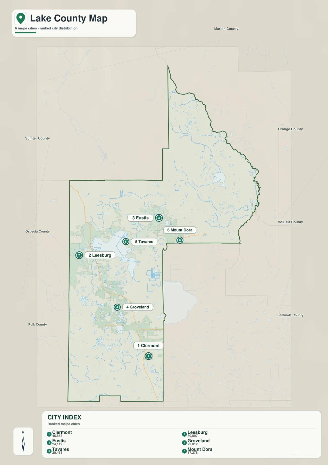
The city map highlights a different pattern in the south. Clermont is the largest of the six ranked cities shown on the supplied city map, with Groveland nearby and Minneola just to the north. This southern group is separated from Tavares and the Harris Chain communities by a wide area of lakes, smaller settlements, and connecting highways. The result is a county with several recognizable centers rather than one simple north-to-south strip of development.
US 27, US 441, and roads that work around the water
Several highways explain how the county’s separate communities connect. US 441 runs through the central and northern lake district, linking Mount Dora, Eustis, Tavares, and Leesburg before continuing toward Lady Lake. US 27 comes north from the Polk County side, passes through the Clermont and Minneola area, reaches Leesburg, and then continues toward the north. SR 50 is a major east-west route through Clermont and Groveland, while SR 19 provides an important north-south connection through Groveland, Tavares, Eustis, and Umatilla.
These road alignments make more sense when they are compared with the lakes. The central part of the county contains broad stretches of open water, so roads frequently bend between lake shores or use narrow corridors of land. A place on the opposite shore of a lake may look nearby, yet the available road can require a sizable detour. For route planning, the map is therefore most useful when the road network and water bodies are read together rather than separately.
The Harris Chain and the county’s connected waters
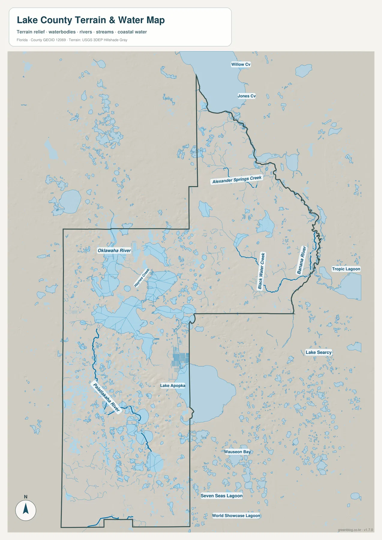
The water map shows why Lake County has such a distinctive layout. Large lakes dominate the central and western sections, surrounded by many smaller ponds, marshes, and connecting channels. The existing source material identifies lakes Apopka, Beauclair, Carlton, Dora, Eustis, Yale, Little Lake Harris, Harris, and Griffin as part of the connected Harris Chain system. Water moves toward Lake Griffin and then into the Ocklawaha River system, so these lakes are better understood as parts of a linked watershed than as isolated blue areas on the map.
The northeast adds another layer to the county’s hydrology. The supplied water map labels the Ocklawaha River near the northern side along with Alexander Springs Creek and Black Water Creek. Many smaller lakes and wet areas are scattered throughout this section. Farther southeast, the broad surface of Lake Apopka touches the county boundary, while numerous smaller lakes continue through the southern half. These features help explain why road connections and settlement patterns vary so sharply from one part of Lake County to another.
From the northeast forest country to the Green Swamp side
The northeast is visually different from the central city-and-lake belt. The existing county material places the Umatilla and Paisley area along the southern side of Ocala National Forest. On the map, fewer large towns appear in that direction, while streams, lakes, and undeveloped areas become more prominent. This helps explain why the long northeastern extension should not be treated as simply another suburb of Tavares or Mount Dora.
Southwestern Lake County is associated in the source material with the Green Swamp, a large natural area important to several river headwaters and groundwater recharge. Around Clermont, lakes are mixed with noticeably rolling uplands, giving this southern area a different character from the broad water-and-marsh landscapes around parts of the central chain. Lake County therefore brings together several settings: older lake towns in the middle, expanding communities in the south, and more lightly settled natural areas toward the northeast and southwest.
Choosing the map that fits the task
Use the county map when you need the full boundary, nearby counties, principal places, and major road connections in one view. The city map is better for comparing the locations of Clermont, Leesburg, Eustis, Groveland, Tavares, and Mount Dora without as much surrounding detail. For lakes, streams, and river connections, the water map makes the Harris Chain area and the Ocklawaha system easier to follow.
These maps are best used as geographic references rather than as live navigation or boating charts. Road work, launch access, water levels, bridge conditions, and temporary restrictions can change. Before a drive, fishing trip, or paddling visit, confirm current conditions with the relevant county, road, park, forest, or water-management agency.
Frequently Asked Questions
Where is the Lake County seat?
Tavares is the county seat. It is located in the central lake district between Lake Dora and Lake Eustis, close to Eustis and Mount Dora and east of Leesburg.
Why does Clermont look separate from the central lake cities?
Clermont is in southern Lake County near Minneola and Groveland. It belongs to a southern group of communities linked by US 27 and SR 50, while Tavares, Eustis, Mount Dora, and Leesburg are arranged around the central chain of large lakes.
How are the Harris Chain lakes connected?
The source material describes the Harris Chain as a connected system whose water ultimately moves toward Lake Griffin and the Ocklawaha River. Looking at the water map makes the relationship between the broad central lakes and the river system much easier to understand.
Map File Information
Download one ZIP containing three high-resolution A3 JPG files for Lake County: the county map, city map, and water map.
- Included Files: County map, city map, water map
Related Maps
- Arcadia Roads and Peace River | DeSoto County Florida Map
- Baker County Florida Map
- Blountstown, SR 20, and the Apalachicola River | Calhoun County Florida Map
Sources
- Lake County Government
- Lake County GIS and Maps
- St. Johns River Water Management District: Lake Griffin
- U.S. Forest Service: Ocala National Forest
Green Map creates custom-edited map images using open geographic data sources such as geoBoundaries, Natural Earth, OpenStreetMap, and government open data.
These maps are edited visual materials, not raw data files, and are provided for education, documents, presentations, and graphic reference.