This Lafayette County Florida Map page focuses on a small rural county built around Mayo, a few important highways, and a long river boundary. U.S. 27 crosses the county through Mayo, SR 51 provides a north-south reference, and the Suwannee River bends along the eastern edge. The three supplied maps separate the county layout, the main city reference, and water features so that each is easier to read. A3 high-resolution JPG versions are also available here as a single ZIP download for printing or offline reference.
Lafayette County does not have a chain of large towns. Mayo is the obvious center, while places such as Day and Hatchbend help orient the northern and southeastern parts of the county. The road map and water map add context that a city-only view cannot provide: the county’s eastern side follows the Suwannee rather than a straight survey line, and the southern interior contains the Steinhatchee River system and numerous smaller creeks and ponds.
Table of Contents
Starting with Mayo and the county’s rural layout
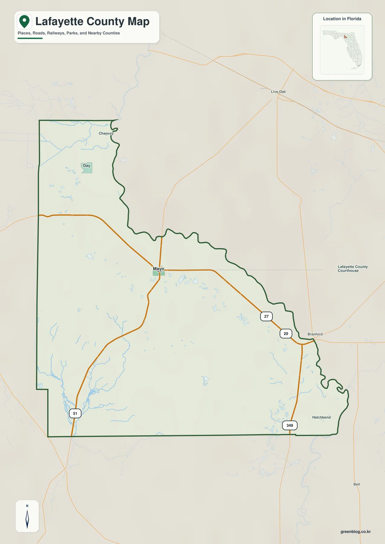
Mayo is the county seat and the clearest settlement reference on the maps. It sits near the middle of Lafayette County where U.S. 27 and SR 51 meet, which makes it useful for understanding almost every other location shown. Day lies to the north, Hatchbend is in the southeast near a large bend of the Suwannee, and Branford appears just beyond the county across the river. Reading these places from Mayo outward is much easier than trying to treat Lafayette County as a network of several comparable urban centers.
The county map also shows why Mayo matters for travel. U.S. 27 arrives from the west, passes directly through town, and continues southeast toward the Suwannee crossing and Branford. SR 51 crosses that route at Mayo and continues north and south. With relatively few major roads elsewhere, this intersection becomes the main visual anchor for anyone trying to understand the county’s road system before looking at smaller local routes.
Following U.S. 27, SR 51, and SR 349
U.S. 27 is the easiest cross-county route to follow. It enters Lafayette County from the west, reaches Mayo, and then angles southeast toward the Suwannee River. Branford is labeled beyond the river and should be read as an outside reference point rather than a town within Lafayette County. That label is still useful because it tells the reader where the highway continues after leaving the county.
SR 51 gives the map a strong north-south reference. North of Mayo, it reaches the Suwannee and continues toward Live Oak outside the county. South of Mayo, the route heads into a much more sparsely settled landscape. SR 349 appears along the southeastern side and connects the lower river area with U.S. 27. Together, the three roads explain most of the county-scale movement visible on the general map without requiring a dense street network.
Day is useful for identifying the northern rural section, while Hatchbend marks the southeast near a broad river curve. Other parts of western and southern Lafayette County contain fewer prominent settlement labels, so roads, creeks, ponds, and the county outline become more important reference points. This is one reason the general county map works best when it is read together with the water map rather than as a simple list of towns.
What the city map says about settlement
The city map makes the county’s settlement pattern unusually clear. Mayo is the only ranked major city shown, and the rest of the county is largely rural. Instead of comparing several urban centers, the reader can use Mayo as a single reference point and then look outward toward Suwannee County and Gilchrist County to the east, Madison and Taylor counties to the west, and Dixie County to the south.
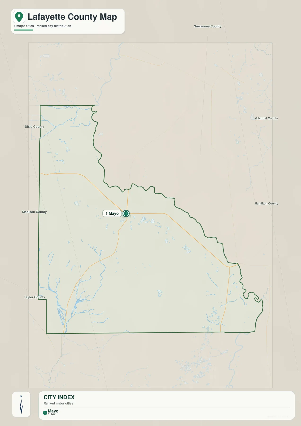
This simplified view is useful because it prevents small rural place names from competing with the one settlement most readers need first. Mayo sits near the road junction that organizes local travel, while much of the southern half has no comparable town marker. If the goal is to understand where people and services are concentrated, this map gives the quickest answer; if the goal is to understand the landscape around those settlements, the county and water maps provide the necessary detail.
The Suwannee boundary and the southern water system
The Suwannee River is the most distinctive natural line on the maps. It forms the long eastern boundary and bends repeatedly from the northeast toward the southeast. Those bends explain why the county edge is irregular on the river side while several western and southern boundary segments are much straighter. The river also helps distinguish inside and outside place labels: Branford and other references across the water are useful for orientation but are not part of Lafayette County.
The water map adds many features that are easy to miss on the general county view. Fourmile Creek and Sand Pond appear in the northwestern part of the county. Farther south and east are Old Grassy Lake, Tenmile Pond, Alton Lake, Wash Pond, Sears Lake, Picket Lake, and Adams Lake. These are not presented as one large lake district; instead, they are scattered across a broad rural interior and help show how frequently small water bodies break up the otherwise open map.
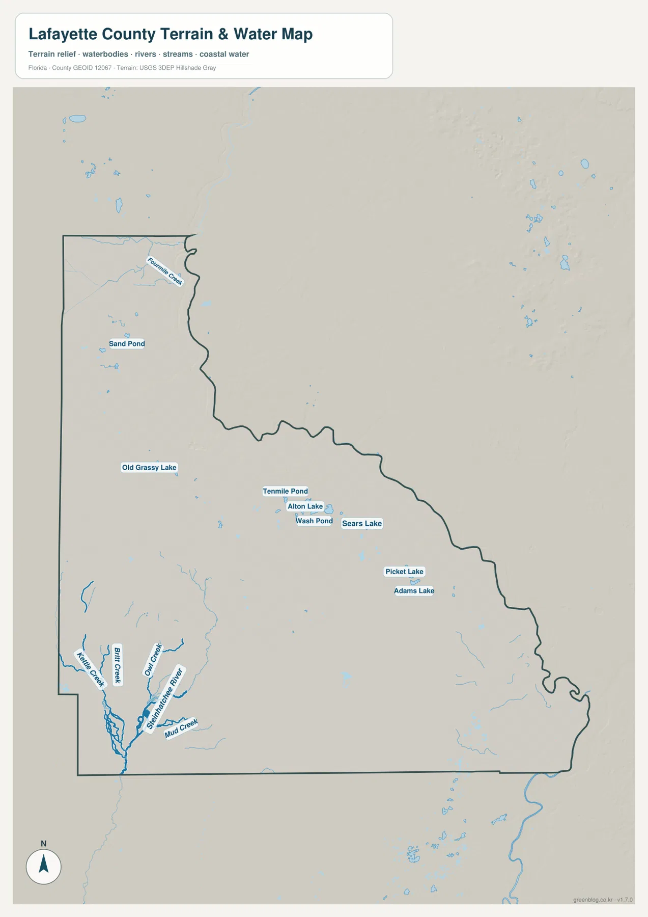
Southern Lafayette County is especially important because not every stream there belongs to the Suwannee side of the map. The Steinhatchee River is labeled in the southwest, along with Kelly Creek, Bird Creek, Owl Creek, and Mud Creek. Seeing these names together makes it clear that the county contains another drainage direction in addition to the dominant Suwannee boundary. A reader interested in water geography should therefore compare the eastern river edge with the southwestern creek network rather than assuming all local water flows toward the same river.
Choosing the right Lafayette County map
Use the general county map when you need the broadest combination of roads, places, and boundary shape. It is the best starting point for locating Mayo, Day, the route toward Branford, and the relationship among U.S. 27, SR 51, and SR 349. The city map removes much of that detail and is better when the main question is simply where Mayo sits within the county and how Lafayette County relates to its neighbors.
The water map becomes the better choice when rivers, creeks, ponds, and the irregular eastern edge are the main interest. It shows why the Suwannee is more than a nearby river: it is also a county boundary. It also reveals the Steinhatchee River and smaller southern creeks, plus the scattered inland ponds that are not as prominent on the other maps. Switching among the three views gives a fuller picture without forcing one map to carry every label at once.
These files are suitable for county-level orientation, classroom work, printed reference sheets, and planning a general trip route. They should not be treated as parcel maps, regulatory flood maps, current road-closure maps, or navigation instructions. For decisions that depend on legal boundaries, flood status, or present-day access conditions, use the responsible county or state agency’s latest official information.
Frequently Asked Questions
Which side of Lafayette County follows the Suwannee River?
The Suwannee River forms the long eastern boundary. Its repeated bends create the irregular shape visible on that side of the county. Roads such as U.S. 27 and SR 51 cross the river toward places outside Lafayette County, so the river is both a natural feature and a useful line for understanding where the county ends.
Why is Mayo the only city emphasized on the city map?
The supplied city map ranks major cities and shows Mayo as the primary urban reference within Lafayette County. The county is otherwise predominantly rural, with smaller communities and scattered development rather than several large towns. That makes Mayo the most practical starting point for reading roads and directions on the other maps.
Does the water map show more than the Suwannee River?
Yes. It also labels the Steinhatchee River in the south, several creeks including Kelly, Bird, Owl, and Mud creeks, and inland water bodies such as Old Grassy Lake, Alton Lake, Picket Lake, Adams Lake, Tenmile Pond, and Sand Pond. These features make the water map the most detailed choice for understanding the county’s drainage and scattered surface water.
Map File Information
The ZIP contains the Lafayette County general map, city map, and water map as high-resolution A3 JPG files for printing or offline reference.
- Included Files: County map, city map, water map
Related Maps
- Arcadia Roads and Peace River | DeSoto County Florida Map
- Baker County Florida Map
- Blountstown, SR 20, and the Apalachicola River | Calhoun County Florida Map
Sources
- U.S. Census Bureau QuickFacts — Lafayette County, Florida
- Lafayette County official website — Our County
- Florida Department of Transportation — Lafayette County General Highway Map
- Florida State Parks — Lafayette Blue Springs State Park
Green Map creates custom-edited map images using open geographic data sources such as geoBoundaries, Natural Earth, OpenStreetMap, and government open data.
These maps are edited visual materials, not raw data files, and are provided for education, documents, presentations, and graphic reference.