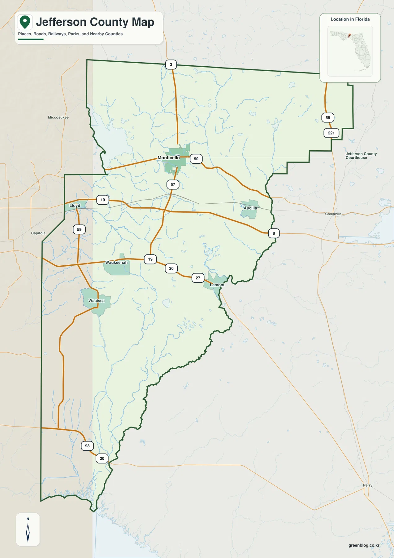
This Jefferson County Florida Map follows a county with an unusually long north-to-south footprint, stretching from the Georgia state line to the Gulf of Mexico. The page combines a general county map, a city map, and a terrain-and-water map so you can locate Monticello, follow the major highways, and see how lakes, creeks, rivers, wetlands, and coastal water shape the southern half. High-resolution A3 JPG versions of all three maps are available in the download box below for printing, classroom work, trip notes, or offline reference.
Jefferson County is easiest to understand by starting in the north and then moving south. Monticello sits in the northern part of the county where U.S. 19 and U.S. 90 meet, while Interstate 10 crosses farther south. Beyond the more settled northern area, communities become smaller and farther apart. The county narrows toward the Gulf, and waterways become increasingly important to both the landscape and the county boundary. Jefferson County’s official website describes it as Florida’s only county that reaches from Georgia all the way to the Gulf of Mexico, a distinction that is immediately visible on the full county map.
Table of Contents
Monticello anchors the road network in the northern part of the county
Monticello is the clearest orientation point on the general map. It is the county seat, and the crossing of U.S. 19 and U.S. 90 makes it a useful reference for travel in several directions. U.S. 19 runs north toward Georgia and south toward Interstate 10, while U.S. 90 links the Monticello area with the Tallahassee side of north Florida and places to the east. I-10 passes south of town rather than through the center, so the county’s long-distance east-west traffic corridor is separated from the historic and administrative center.
Other mapped communities help define the rural portions of Jefferson County. Lloyd appears to the west near I-10 and SR 59. Waukeenah is southwest of Monticello, with Wacissa farther south. Lamont sits toward the southeast along the U.S. 27 side of the county, while Aucilla is marked near the eastern side. These places are not packed into one continuous urban strip. They are separated by farms, forests, wetlands, and long stretches of local road, which is why the road map is more useful than a simple list of place names.
The outline itself tells part of the story. The northern Georgia boundary is comparatively straight, but the eastern and southeastern sides become irregular as the county approaches river country. Farther south, Jefferson County becomes much narrower before reaching a short section of Gulf coast. A trip from Monticello to the southern end therefore crosses a much greater change in landscape than the compact northern road network might suggest.
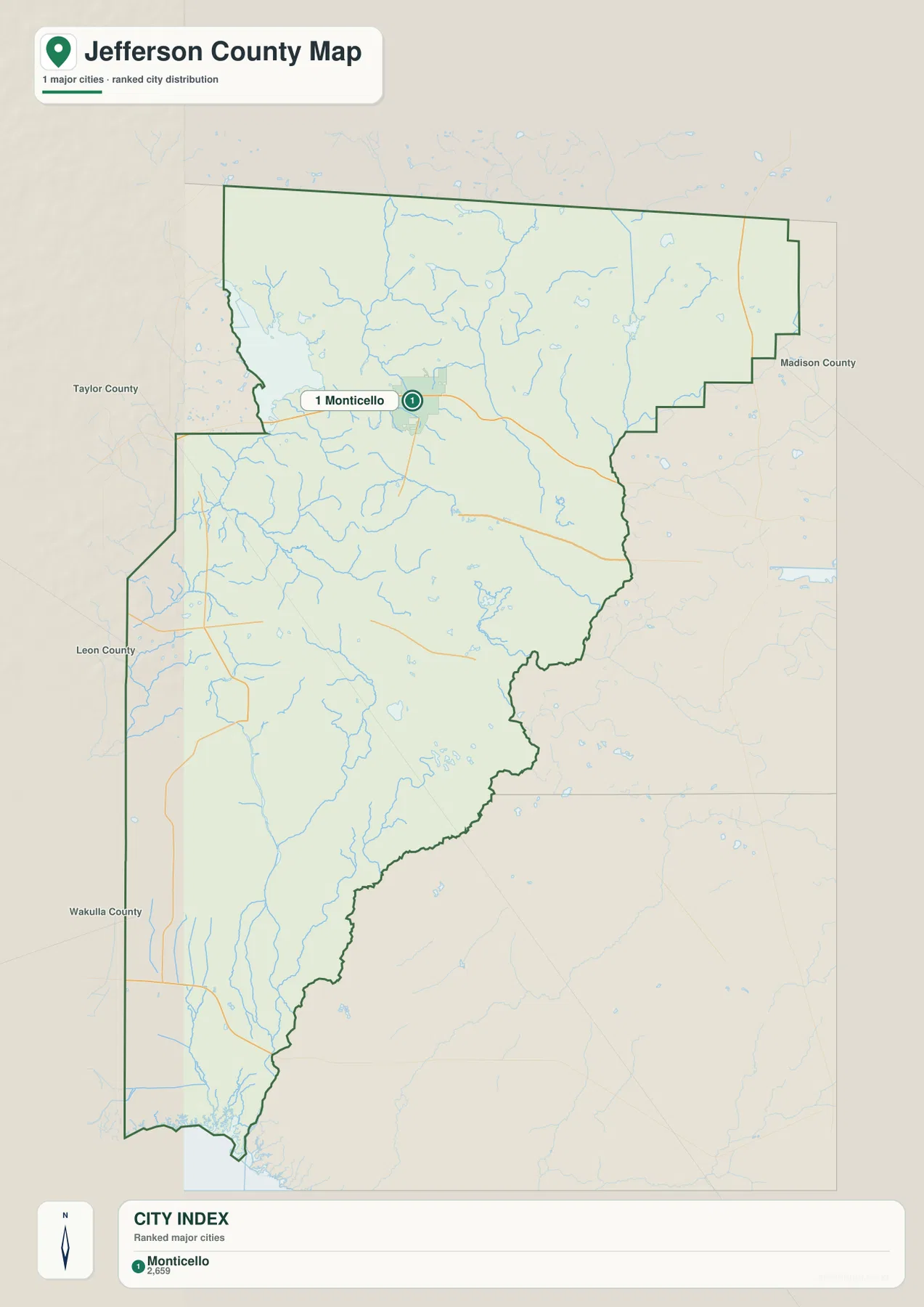
A city map dominated by Monticello rather than a chain of large towns
The city map strips away much of the road and place-name detail and makes the settlement pattern obvious. Monticello is the single ranked major city shown, positioned in the northern portion of the county. That simplicity is useful because Jefferson County can otherwise look more urban than it really is when every community label, road, and water feature is displayed at once. The county is better described as one small incorporated center surrounded by a large rural area than as a corridor of similar-sized municipalities.
This also explains the large blank areas on the city view. Lloyd, Waukeenah, Wacissa, Lamont, and Aucilla are important local reference points, but they do not appear as equivalent ranked cities on this map. Their absence from the city index does not mean the land is empty. When the city map is compared with the water map, the southern half is revealed as a landscape of rivers, creeks, wetlands, managed forest, and sparsely settled road networks rather than an undeveloped gap between towns.
For practical orientation, Monticello is also a useful dividing point between the Tallahassee-facing northern road network and the long rural routes that lead south. U.S. 90 provides the east-west connection through town, while U.S. 19 reaches I-10 and continues south. Visitors heading toward Wacissa or the lower river country eventually leave the more obvious highway pattern and rely on smaller roads, so a city-only map is best used together with the county and water references.
Water geography runs from Lake Miccosukee to the Wacissa, Aucilla, and Gulf coast
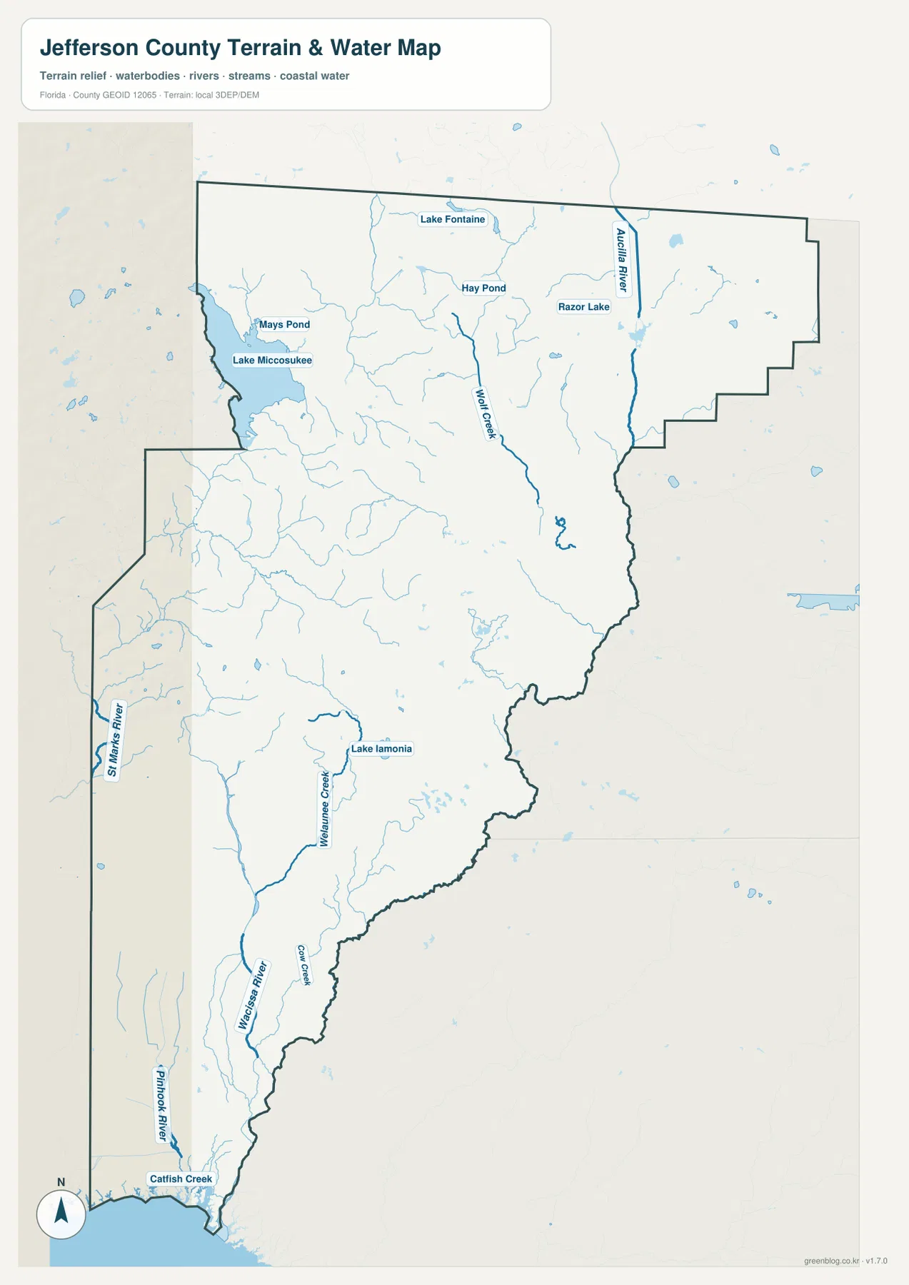
The terrain-and-water map changes the emphasis from roads to drainage. Lake Miccosukee is the largest named water feature near the northwest side, with Mays Pond close by. Farther north and east, Lake Fontaine, Hay Pond, and Razor Lake appear among a web of small streams. Wolf Creek and the Aucilla River stand out in the eastern part of the county. This dense network of smaller water features is easy to overlook on a road map, but it helps explain why the rural landscape is broken by wetlands, ponds, and creek valleys.
The western and southern sections add another set of waterways. The St. Marks River lies along the western side, while Lake Iamonia and Weelaunee Creek are shown near the west-central portion of the map. The Wacissa River becomes one of the strongest labels farther south, joined on the map by Cox Creek, Pinhook River, and Catfish Creek near the lower county. At the very bottom, coastal water confirms that Jefferson County reaches the Gulf rather than stopping inland.
The Wacissa and Aucilla rivers are especially important for understanding southern Jefferson County. The county’s recreation information describes the Wacissa as a clear, spring-fed stream with numerous tributaries and wetland channels. The Aucilla is a darker river with shoals and limestone features; in its lower course it can disappear into sinkholes and reemerge before continuing toward the Gulf system. The rivers eventually connect, so the long southern section of the county is better understood as river and wetland country than simply as a sparsely populated extension of Monticello.
Lake Miccosukee provides a northern contrast. Jefferson County’s official profile highlights the lake along the northwest border and notes the county’s many ponds, lakes, and three major rivers. On the water map, that northern lake-and-creek landscape gradually gives way to the Wacissa-Aucilla system and coastal water in the south. The result is a county where water features change character over a relatively long north-south distance.
The landscape changes noticeably between the northern hills and southern lowlands
Jefferson County’s northern landscape is associated with the rolling hill country around Monticello, while the south becomes lower, wetter, and more strongly shaped by rivers, marshes, and forest. The county’s own geographic description emphasizes rolling hills and wooded acreage in the north Florida setting, along with the extensive lakes and rivers that occupy the county. That contrast is visible indirectly in the map set: northern Jefferson has the clearest concentration of roads and settlements, while the southern section is dominated by water labels and large areas with few town names.
That difference matters when planning a visit. Around Monticello, route choices can usually be organized around U.S. 19, U.S. 90, and I-10. In the Wacissa and Aucilla river country, however, the exact access road, launch point, water level, land manager, and current conditions matter more. The county’s recreation page specifically warns that parts of the Aucilla are challenging for canoeists because of swift current, shoals, old rock dams, and disappearing river sections, while the Wacissa is described as a more accessible spring-fed canoe trail. A general map can show where these places are, but it should not replace current recreation or safety information.
The irregular eastern boundary also makes more sense in this context. Unlike the straight state line across the north, portions of the eastern and southeastern county edge follow a landscape shaped by the Aucilla system and nearby wetlands. Reading the county outline together with the water map helps explain why the boundary bends repeatedly instead of following a simple grid. It is a good example of a county where natural geography is part of the administrative shape.
Which Jefferson County map should you use?
Use the general county map when you need the broadest orientation. It is the best choice for locating Monticello, Lloyd, Waukeenah, Wacissa, Lamont, and Aucilla while following I-10 and the major U.S. routes. It also gives the clearest view of the entire county outline, including the straight Georgia line in the north and the narrow extension to the Gulf in the south.
Use the city map when the main question is where Monticello sits within Jefferson County. Its simplified presentation removes most competing labels and makes the county’s largely rural settlement pattern easy to see. Choose the water map when Lake Miccosukee, the St. Marks River, Wacissa River, Aucilla River, smaller creeks, or the Gulf coast matters more than town locations. Switching between the three views gives a more complete picture than trying to make one map carry every type of detail.
These maps are designed for county-level reference, printing, learning, and general trip preparation. They are not parcel surveys, legal jurisdiction maps, real-time navigation products, regulatory flood maps, or boating charts. For property boundaries, road closures, flood decisions, river access, or other time-sensitive questions, use the current product from Jefferson County, FDOT, Florida DEP, or the public agency responsible for that specific purpose.
Frequently Asked Questions
Does Jefferson County really extend from Georgia to the Gulf of Mexico?
Yes. Jefferson County’s official website describes it as Florida’s only county that borders Georgia in the north and reaches the Gulf of Mexico in the south. The full county map makes that unusual shape easy to see, with a broad northern section that narrows as it approaches the coast.
Where is Monticello on the Jefferson County map?
Monticello is in the northern part of Jefferson County and serves as the county seat. It lies at the U.S. 19 and U.S. 90 junction, with I-10 several miles to the south, making it the easiest road reference for the northern half of the county.
How are the Wacissa and Aucilla rivers related?
The Wacissa is a clear, spring-fed river that flows south through wetland channels and eventually connects with the Aucilla system. The Aucilla has a different blackwater character and is known for limestone sinks where parts of the river disappear underground and reemerge. Together they define much of the geography of southern Jefferson County.
What is included in the Jefferson County Florida map download?
The download contains three high-resolution A3 JPG files: a general county map with roads and place names, a city map centered on Monticello, and a water map showing Lake Miccosukee, major rivers and creeks, and the Gulf coast.
Map File Information
The ZIP contains all three Jefferson County maps from this page as high-resolution A3 JPG files. Download the archive for larger offline images, printing, classroom use, or personal geographic reference.
- Included Files: County map, city map, and water map
Related Maps
- Jefferson County Texas map | Beaumont and Neches River
- Arcadia Roads and Peace River | DeSoto County Florida Map
- Baker County Florida Map
Sources
- Jefferson County official website — About Jefferson
- Jefferson County official website — Recreation & Tourism
- Florida Department of Transportation — Jefferson County General Highway Map
- Florida Department of Environmental Protection — Wacissa River and Wacissa Springs report
- U.S. Geological Survey — National Hydrography
Green Map creates custom-edited map images using open geographic data sources such as geoBoundaries, Natural Earth, OpenStreetMap, and government open data.
These maps are edited visual materials, not raw data files, and are provided for education, documents, presentations, and graphic reference.