Jackson County, Florida sits in the northern Panhandle where local roads, small towns, river corridors, and two state lines all matter at the same time. This page brings those features together in a county reference map, a city map, and a terrain-and-water map. High-resolution A3 JPG copies of the same maps are also available in the ZIP download box below, so visitors can move from a quick on-screen look to a printable file without searching for a separate download page.
Marianna is the county seat and the main central reference point, but Jackson County extends far beyond the city. Graceville and Campbellton lie toward the northwest, Malone is close to the Alabama line in the north, and Grand Ridge and Sneads are east of Marianna toward the large water bodies at the county’s eastern edge. The county also touches Georgia in the northeast. Looking at roads and waterways together is especially useful here because the western, central, northern, and eastern communities are connected by different routes rather than by one continuous urban corridor.
Table of Contents
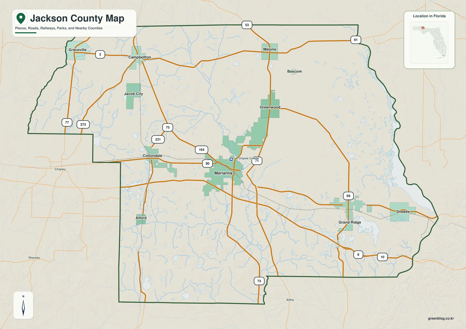
Marianna, U.S. 90, and the central road network
Marianna occupies the center of the county map and works well as the starting point for orientation. U.S. 90 passes east-west through the city area, while State Road 71 provides an important north-south connection. Interstate 10 runs south of central Marianna, so the interstate and the older town-to-town road do not serve exactly the same purpose. A traveler crossing the Panhandle on I-10 can move quickly through the county, while a person trying to reach Marianna, Cottondale, Grand Ridge, or Sneads will often leave the interstate and use the local north-south connectors or U.S. 90.
West of Marianna, Cottondale stands at a useful road junction where U.S. 90 meets U.S. 231. U.S. 231 continues north toward Campbellton and the Alabama line and south toward other parts of the Florida Panhandle. This makes Cottondale different from a simple western suburb of Marianna: it is a crossing point between an east-west route and one of the county’s strongest north-south highways. Graceville lies farther northwest near the county boundary, and Jacob City is set within the rural area between the larger road corridors.
North of Marianna, Greenwood and Malone are easier to understand in relation to State Road 71 than to I-10. Malone is close to the Alabama border, where local movement naturally turns toward the state line rather than back toward the interstate. Bascom appears in the northeastern part of the map, near the Georgia side of the county. These places show why a single “distance from Marianna” measure can be misleading: each community belongs to a slightly different road setting.
A spread-out town pattern from Graceville to Sneads
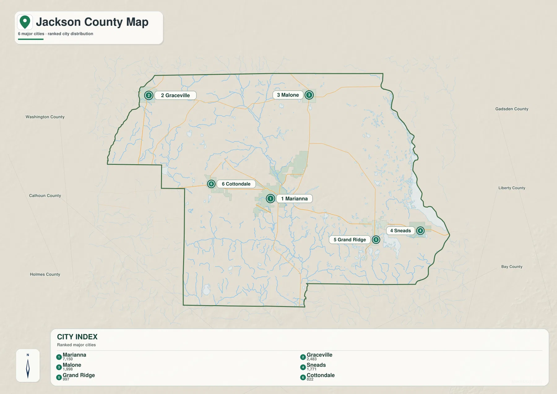
The city map strips away much of the road detail and makes the settlement pattern easier to compare. Marianna is the most prominent city in the middle of the county. Graceville is placed in the northwest, Malone along the northern side, Cottondale to the west of Marianna, and Grand Ridge and Sneads to the east. The spacing between these places is important. Jackson County is not a single metropolitan area with closely packed municipalities; it is a large rural county where distinct towns are separated by farmland, forest, creeks, and unincorporated land.
The east-west sequence is especially clear. U.S. 90 links Cottondale, Marianna, Grand Ridge, and Sneads, but those communities do not form an uninterrupted built-up strip. Marianna has the strongest concentration of services and county government, while Grand Ridge and Sneads sit in a quieter eastern landscape. Farther northwest, Graceville is oriented toward the county and state boundaries, and Malone is tied to the northern State Road 71 corridor. Using the city map beside the county map makes those differences easier to see than using a list of place names alone.
The city index on the map is useful for a relative comparison of the six highlighted municipalities, but it should not be treated as a legal boundary map. Jackson County maintains a separate jurisdiction map for incorporated municipal limits and warns that general reference mapping should not be used as a legal determination of jurisdiction. A Marianna postal address, for example, does not automatically mean a property lies within the incorporated city. For planning, permitting, zoning, or property questions, the official jurisdiction source is the better next step.
The Chipola River, spring-fed water, and the eastern reservoir edge
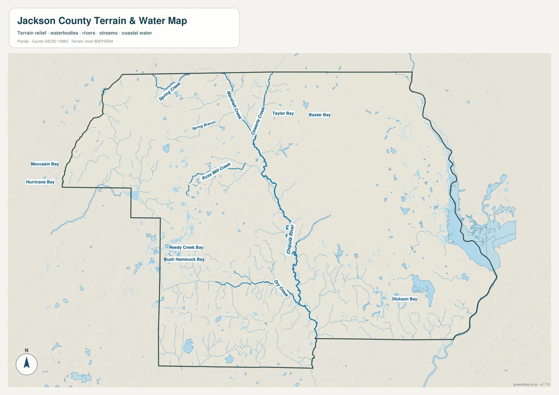
Water changes the character of Jackson County more than a basic highway map suggests. The terrain-and-water map shows the Chipola River running through the central part of the county, with a dense web of smaller streams feeding into it. Spring Creek, Marshall Creek, Cowarts Creek, and other tributaries are visible in the north and center, while smaller branches spread across the western and southern sections. This network helps explain why the area around Marianna is known for springs, caves, and clear-water features rather than only for the flat coastal scenery often associated with Florida.
Florida Caverns State Park lies near Marianna along the Chipola River. Florida State Parks describes limestone formations more than 30 million years old, along with caves, sinkholes, springs, limestone bluffs, and other karst features. The park is also notable because it is the only Florida state park where visitors can take a guided walking tour through a large cave system. Those details make the park more than a tourism marker on a local map: it is evidence of the limestone landscape beneath the northern Panhandle.
Another useful local reference is Merritt’s Mill Pond, a spring-fed impoundment near Marianna. The Florida Fish and Wildlife Conservation Commission describes it as a clear, spring-fed lake in Jackson County. Its position east of central Marianna helps connect the road map with the water map, especially for readers who are trying to understand why several recreation areas and springs are clustered around the Chipola system. The county’s water geography includes both flowing rivers and smaller spring-fed lakes, ponds, bays, and wet areas.
The eastern side of the county looks different again. Near Sneads, the map opens into a broad water landscape associated with Lake Seminole and the Jim Woodruff Dam area. The Chattahoochee and Flint rivers meet in that region, and the Apalachicola River begins below the dam. The Chipola River is a separate river system that flows south from the Marianna area before joining the Apalachicola farther downstream. Keeping those channels separate prevents a common mistake: the central Chipola corridor and the eastern Apalachicola-Lake Seminole setting are connected within the broader basin but are not the same river.
Why the Alabama and Georgia borders matter
Jackson County is one of the Florida counties where a state map is genuinely useful for local orientation. The county government describes Jackson County as part of a tri-state community because it borders both Alabama and Georgia. That geography is visible in the northern county outline: the northwest is oriented toward Alabama, while the northeastern corner reaches Georgia. Inside Florida, the county meets Holmes, Washington, Bay, Calhoun, and Gadsden counties. These neighboring areas help explain why the county outline is irregular and why travel directions differ so much from one side to another.
For Graceville, Campbellton, and Malone, the northern border is not a distant edge; it is part of everyday geographic context. U.S. 231 provides the strongest north-south connection in the western half, while State Road 71 performs a similar role through the central-northern part of the county. By contrast, Marianna, Cottondale, Grand Ridge, and Sneads are more closely associated with the east-west U.S. 90 and I-10 corridors. The map is most useful when those routes are treated as a network rather than as a hierarchy in which the interstate is always the only important road.
The eastern boundary also carries a natural rather than purely administrative character. Large water bodies and river channels dominate the area around Sneads and the Lake Seminole system. This makes the eastern edge visually different from the straighter western and northern land boundaries. For a classroom, trip-planning, or general geographic reference, comparing the county outline with the water map is a simple way to see how political boundaries and physical features overlap.
Choosing the right Jackson County map
Use the county map when you need the broadest overview. It combines the county outline with Marianna, surrounding towns, major highways, local roads, and visible water features. This is the best starting map for understanding where a place sits in relation to the rest of Jackson County. It is also helpful for comparing the central U.S. 90 corridor with the northern state-line communities.
The city map is better when the question is simply, “Where are the main towns?” With fewer labels competing for attention, it quickly shows the separation between Graceville, Malone, Cottondale, Marianna, Grand Ridge, and Sneads. The water map is the strongest choice for the Chipola River, tributaries, spring-fed features, and the broad eastern reservoir landscape. Switching among the three maps keeps the page useful without forcing one map to carry every type of detail.
These maps are designed for general reference, education, travel planning, and geographic comparison. They are not parcel maps, legal surveys, flood determinations, or official municipal-boundary records. Anyone making a property, permitting, zoning, or jurisdiction decision should move from this overview to the county’s official jurisdiction map and the records of the responsible agency.
Frequently Asked Questions
Where is Marianna within Jackson County?
Marianna is near the center of Jackson County and serves as the county seat. U.S. 90 runs through the city area and State Road 71 provides a north-south route, while I-10 passes south of central Marianna. That combination makes Marianna the easiest reference point for comparing the western, northern, and eastern parts of the county.
What part of Jackson County does the Chipola River cross?
The Chipola River runs through the central part of the county near the Marianna area and receives water from numerous smaller creeks and spring-fed channels. Florida Caverns State Park is located along the river, so the Chipola corridor is closely tied to some of the county’s best-known natural features.
Why does Sneads look more closely tied to large water bodies than Marianna?
Sneads is near the eastern edge of Jackson County, close to the Lake Seminole and Jim Woodruff Dam area. The broad reservoir and river channels dominate that side of the map. Marianna, by comparison, is associated with the narrower Chipola River and spring-fed features in the central county.
Can this map be used to decide whether an address is inside a city limit?
No. This page is a general geographic reference. Jackson County provides a separate jurisdiction map and notes that municipal boundaries should be checked with official records when a legal or administrative determination is needed. A postal place name should not be assumed to match an incorporated boundary.
Map File Information
The download contains the three Jackson County maps shown on this page as high-resolution A3 JPG files. They are packaged together in one ZIP for convenient printing, study, and offline reference.
- File Type: ZIP containing three high-resolution A3 JPG files
Related Maps
- Arcadia Roads and Peace River | DeSoto County Florida Map
- Baker County Florida Map
- Blountstown, SR 20, and the Apalachicola River | Calhoun County Florida Map
Sources and References
- Jackson County government – About Jackson County
- Jackson County government – County jurisdiction map
- Florida State Parks – Florida Caverns State Park
- Florida Fish and Wildlife Conservation Commission – Merritt’s Mill Pond
- Florida Department of Transportation – Official Transportation Map
- U.S. Geological Survey – National Hydrography
Green Map creates custom-edited map images using open geographic data sources such as geoBoundaries, Natural Earth, OpenStreetMap, and government open data. These maps are edited visual materials, not raw data files, and are provided for education, documents, presentations, and graphic reference.