Download the high-resolution A3 JPG maps from this Indian River County Map page when you need a larger reference than the WebP previews shown in the article. The maps cover the county boundary and major roads, the five incorporated municipalities, and the water landscape from Blue Cypress Lake to the Indian River Lagoon and Atlantic coast. They are designed for straightforward geographic reference, so a visitor can locate Vero Beach, Sebastian, Fellsmere, I-95, and the county’s major water features before choosing the map file that best fits the task.
Indian River County is easy to mistake for a narrow coastal county if you focus only on Vero Beach and the beaches. In reality, it extends far inland. The eastern side contains the county’s best-known communities, the lagoon, the barrier-island shore, and a dense set of roads. West of I-95, the pattern changes toward Fellsmere, managed water lands, canals, marshes, and Blue Cypress Lake near the headwaters of the St. Johns River. Reading the county from east to west is the simplest way to understand why its city map and water map look so different.
Table of Contents
The county map connects Vero Beach to a much wider inland area
Indian River County faces the Atlantic Ocean on the east, with Brevard County to the north and St. Lucie County to the south. Its western side reaches toward Okeechobee and Osceola counties. That broad outline matters because the county’s settled east coast occupies only part of the total area. Vero Beach and Sebastian sit in the eastern half, while Fellsmere lies well inland, closer to the large wetland and water-management landscape that surrounds the upper St. Johns River basin.
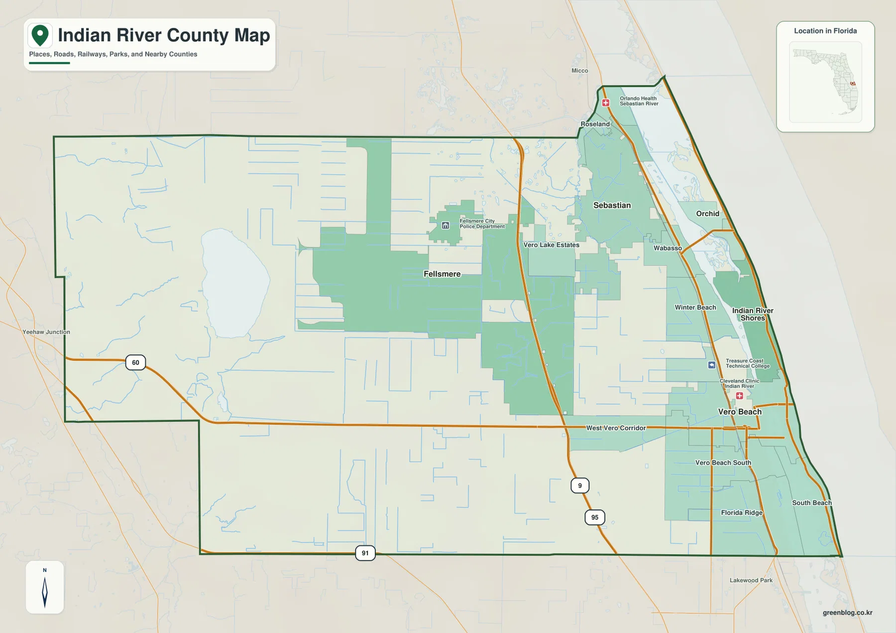
I-95 provides the clearest north-south reference line on the county map. It runs inland from the lagoon and oceanfront communities rather than directly along the coast. SR 60 crosses I-95 at Exit 147 and continues east toward Vero Beach, making it the most useful route for orienting the central part of the county. Farther north, CR 512 meets I-95 at Exit 156; from there the road leads east toward Sebastian and west toward Fellsmere. The Florida Department of Transportation exit list confirms both interchanges.
Once those two crossings are fixed in mind, many of the smaller place labels become easier to place. Vero Lake Estates and Fellsmere occupy the inland side of the eastern settlement belt, while Wabasso, Winter Beach, West Vero Corridor, Vero Beach South, and Florida Ridge sit closer to the built-up coastal half. Roseland is north of Sebastian, and Indian River Shores appears on the barrier-island side of the lagoon. The map is therefore useful not only for finding the county seat but also for seeing how named communities spread across the mainland and coastal strip.
The road pattern also warns against assuming that a place that looks close on the page is reached by a direct route. The Indian River Lagoon separates mainland communities from the barrier island, and the county’s western wetlands limit the dense road grid seen around Vero Beach. For trip planning, the county map works best as an orientation layer: identify the interstate, the main east-west road, the lagoon, and the destination community, then confirm detailed directions with a current navigation source.
Five municipalities occupy three very different settings
The city map isolates Sebastian, Vero Beach, Fellsmere, Indian River Shores, and Orchid, the county’s five incorporated municipalities. Vero Beach is the county seat and sits in the central-eastern part of the mainland. Sebastian is farther north on the mainland side of the lagoon. Fellsmere stands apart to the west of I-95, while Indian River Shores and Orchid occupy the narrow coastal side east of the lagoon. This distribution explains more about the county than a simple list of city names does.
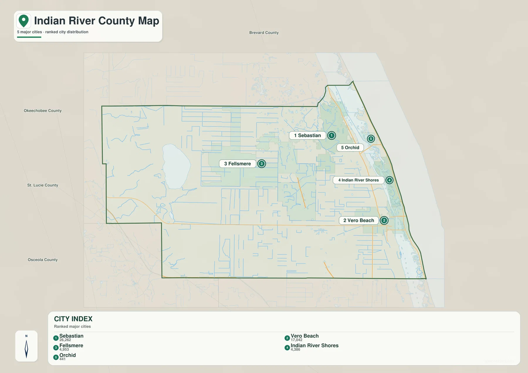
Sebastian and Vero Beach are the two largest incorporated places shown on the map, and both are tied to the eastern road and lagoon corridor. Their locations can make the county appear heavily coastal when viewed only through population centers. Fellsmere provides the counterexample. It sits in a broad inland setting connected eastward by CR 512, with the upper St. Johns River basin and large managed-water areas nearby. Its surroundings are less densely labeled because roads and settlements are more widely spaced, not because the landscape lacks important features.
Indian River Shores and Orchid show a third pattern. They lie east of the Indian River Lagoon on the barrier-island side, where water separates them from the mainland road network. Their placement is especially useful when a visitor is trying to understand the relationship between a Vero Beach mainland address, a beach destination, and the lagoon. Instead of treating “Vero Beach” as one continuous coastal area, the city map makes the mainland-water-barrier-island sequence visible.
Blue Cypress Lake and the lagoon reveal the county’s east-west water contrast
The water map changes the emphasis completely. In the west, Blue Cypress Lake is one of the most obvious features, with Blue Cypress Creek, St. Johns Marsh, Padgett Branch, and Gum Slough labeled around the inland wetland system. In the northeast, South Prong and Schumann Lake appear near the Sebastian area. Along the coast, the Intracoastal Waterway, Indian River, and Atlantic Ocean form a long north-south sequence beside the barrier island. Smaller labels such as Main Canal, Big Starvation Cove, and Blue Hole Creek add detail to the coastal side.
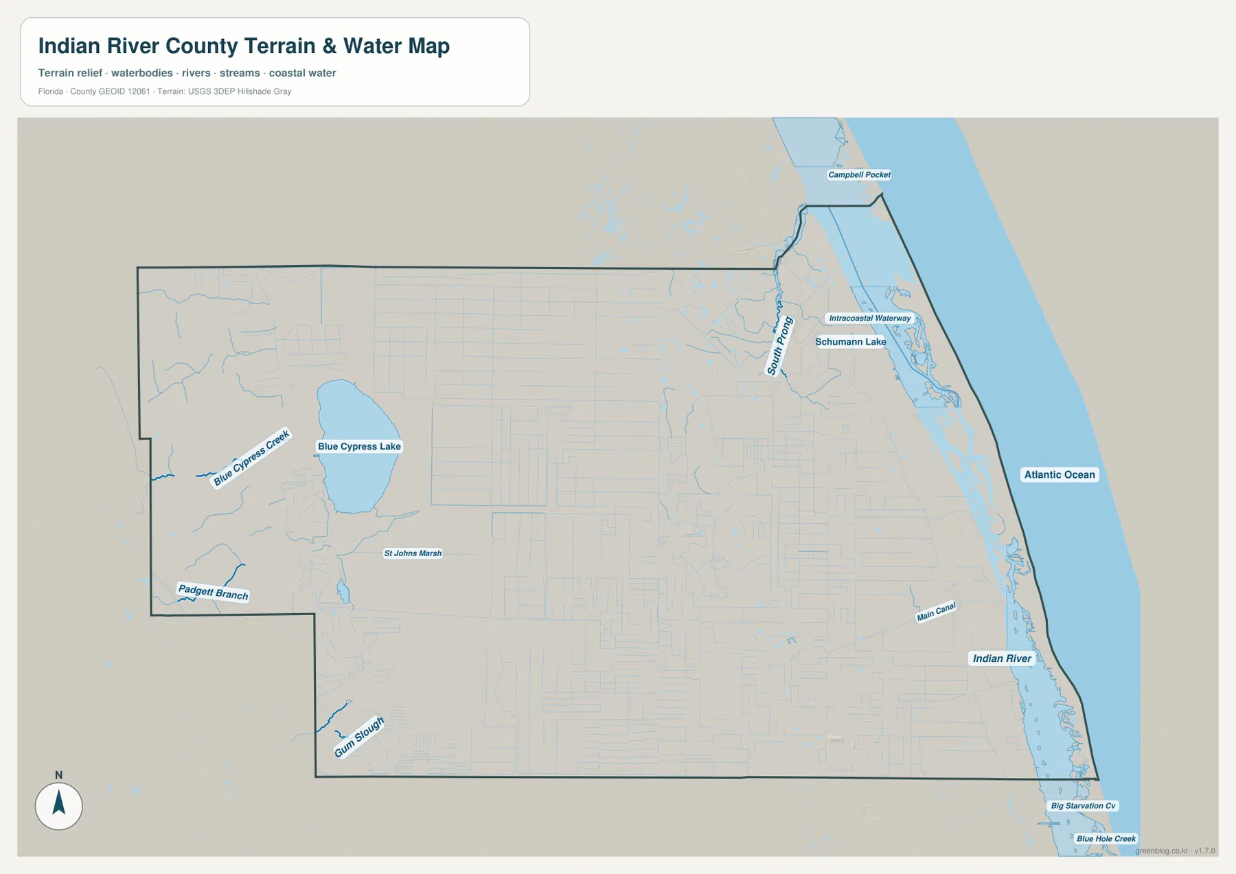
Blue Cypress Lake belongs to the Upper St. Johns River Basin setting west of Vero Beach. The St. Johns River Water Management District describes the Blue Cypress Conservation Area as part of the Upper St. Johns River Basin Project, a long-term effort to reduce flooding, restore more natural hydrologic cycles, protect water quality, and reduce damaging freshwater diversions toward the Indian River Lagoon. The district also manages the Fellsmere Water Management Area, a 10,000-acre water and wetland restoration feature that provides storage, treatment, habitat, and recreation functions.
Those official descriptions help explain why the western half of the water map contains so many marsh and canal features even though the city map looks comparatively empty there. This is the headwater landscape of the St. Johns River, not simply unused space beyond the interstate. Blue Cypress Lake, marshes, managed water areas, and drainage channels form a major part of the county’s geography and are a strong contrast to the estuarine and ocean waters on the east side.
The “Indian River” label on the coastal side should also be read carefully. Here it refers to a portion of the Indian River Lagoon estuarine system rather than a conventional freshwater river flowing from a single headwater to one mouth. The long water body lies between the mainland and barrier island, with Atlantic coastal water beyond. That arrangement is why mainland places and beach communities may be close in straight-line distance but still depend on bridge crossings and a limited set of road connections.
Which map file should you use?
Choose the county map when you need the broadest geographic reference. It is the best option for finding the county line, checking whether a place is east or west of I-95, following SR 60 toward Vero Beach, or comparing Sebastian and Fellsmere with surrounding communities. It also gives enough road context to understand how the eastern population centers relate to the much larger inland portion of the county.
Choose the city map when the incorporated municipalities are the main question. Because the map removes much of the extra place detail, the relative positions of Sebastian, Vero Beach, Fellsmere, Indian River Shores, and Orchid are easier to compare. It is particularly helpful for distinguishing the two barrier-island municipalities from the mainland cities and for seeing how far Fellsmere sits from the coastal group.
Choose the water map when Blue Cypress Lake, the upper St. Johns River wetlands, the Indian River Lagoon, the Intracoastal Waterway, or the Atlantic coast matters more than municipal boundaries. The map is a geographic reference, not a flood map, navigation chart, parcel map, or legal boundary product. For flood risk, evacuation, property, engineering, or boating decisions, use the current official product made for that purpose.
The downloadable JPG files correspond to the same three subjects shown in the article previews. Keep the county map for roads and place names, the city map for municipal locations, and the water map for the lake-marsh-lagoon relationship. Because these are reference maps, a current county GIS or agency map remains the better source whenever a legal boundary or time-sensitive public-safety decision is involved.
Frequently Asked Questions
Where is the county seat of Indian River County?
Vero Beach is the county seat. On the county map it appears in the central-eastern part of Indian River County, east of I-95 and along the SR 60 corridor. Sebastian is farther north, so the two communities should not be treated as the same administrative center.
Why does Fellsmere look so far from the coastal communities?
Fellsmere is an inland municipality west of I-95. CR 512 connects it eastward through the interstate toward Sebastian, but its surroundings are shaped by farms, wetlands, canals, and the Upper St. Johns River Basin rather than by the lagoon and Atlantic shoreline. That difference makes the city stand apart clearly on both the city and water maps.
Is the Indian River on the map a typical freshwater river?
No. In this area, Indian River is part of the Indian River Lagoon estuarine system between the mainland and barrier island. It is a brackish coastal water body influenced by both salt water and freshwater, so it should not be pictured as a narrow river flowing in one direction from a headwater source.
What is included in the downloadable Indian River County map ZIP?
The archive includes three high-resolution A3 JPG files: a county map with roads and place names, a city map locating the five incorporated municipalities, and a water map showing Blue Cypress Lake, upper St. Johns River wetlands, the Indian River Lagoon side, and the Atlantic coast.
Map File Information
The ZIP contains the Indian River County reference map, city map, and water map as high-resolution A3 JPG files. Download the archive when you want larger images for offline reference, printing, classroom work, or trip notes.
- Included Files: 3 JPG maps
Related Maps
- Arcadia Roads and Peace River | DeSoto County Florida Map
- Baker County Florida Map
- Blountstown, SR 20, and the Apalachicola River | Calhoun County Florida Map
Sources
- U.S. Census Bureau QuickFacts: Indian River County
- Indian River County GIS map gallery
- Florida Department of Transportation I-95 exit numbers
- St. Johns River Water Management District: Indian River County
- Fellsmere Water Management Area
- U.S. Fish and Wildlife Service: Pelican Island National Wildlife Refuge
Green Map creates custom-edited map images using open geographic data sources such as geoBoundaries, Natural Earth, OpenStreetMap, and government open data. These maps are edited visual materials, not raw data files, and are provided for education, documents, presentations, and graphic reference.