The Holmes County Florida Map on this page helps you locate Bonifay, the county’s smaller incorporated places, major highways, and the Choctawhatchee River. You can also download the high-resolution JPG map files from the map box below, making the page useful both for quick online reference and for printing or enlarged viewing.
Holmes County is an inland Florida Panhandle county where places are spread across long rural road corridors rather than one continuous urban area. Bonifay lies near US 90 and SR 79, Ponce de Leon and Westville are farther west, and Esto and Noma sit near the Alabama line. The county, city, and water maps show those locations from different angles without adding an elevation map that is not part of this set.
Road numbers and water crossings matter here. I-10 and US 90 carry east–west traffic across the southern part of the county, SR 2 serves the northern border area, and the Choctawhatchee River creates a major north–south natural feature in the west. Looking at those elements together gives a clearer sense of why two places that appear close on the page may use different highway exits or river crossings.
Table of Contents
Three road corridors organize most trips through Holmes County
The county map outlines Holmes County against Alabama on the north and the Florida counties of Jackson, Washington, and Walton on the other sides. It also shows why the southern edge receives more through traffic than the rural north. I-10 crosses the southern part of the county, US 90 runs through the town corridor, and SR 2 follows the northern tier close to the state line. These routes serve different kinds of movement rather than functioning as interchangeable parallel roads.
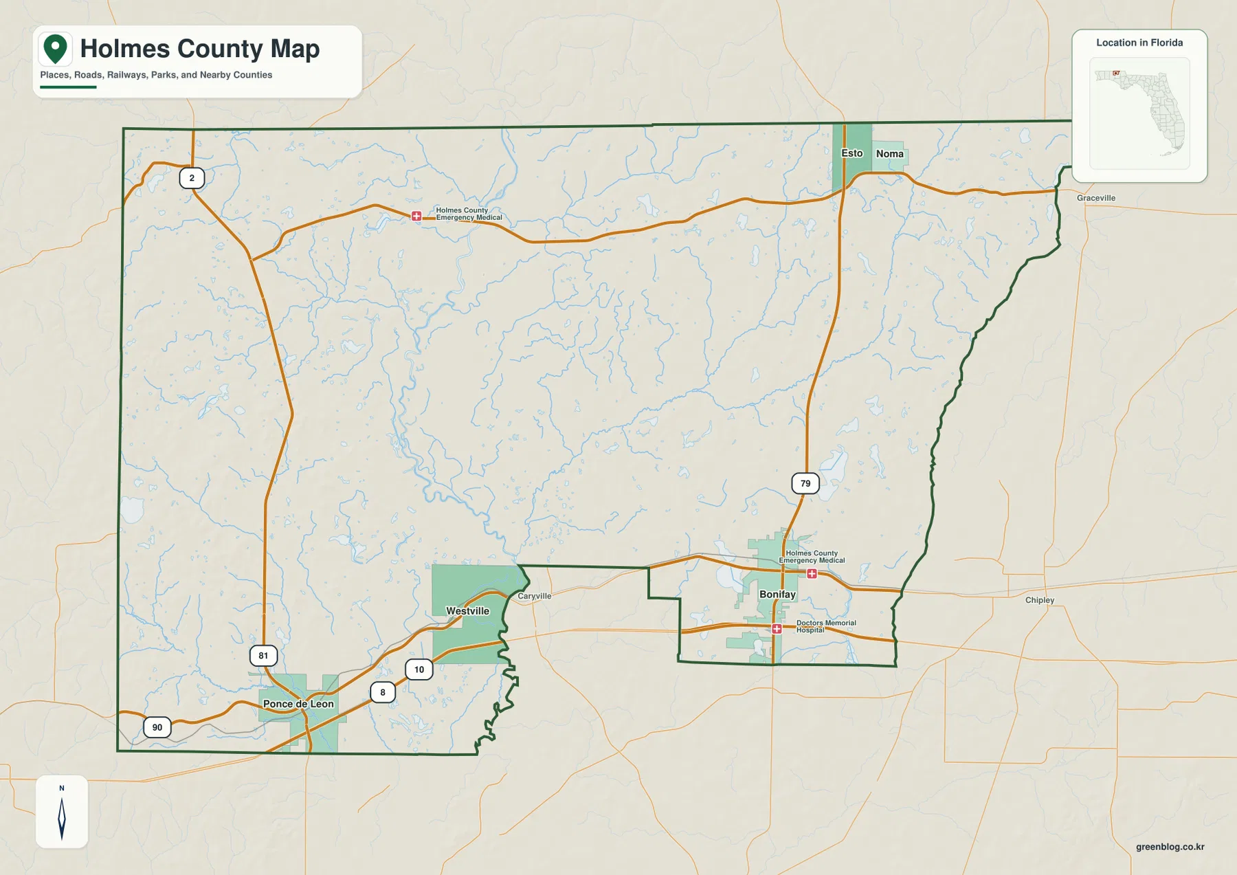
Bonifay is located on the US 90 and SR 79 axis. I-10 lies south of the town center, so travelers leave the freeway and continue north on SR 79 rather than arriving directly in downtown Bonifay. Exit 112 connects I-10 with SR 79 for the Bonifay approach. Farther west, exit 96 meets SR 81 for the Ponce de Leon side of the county. Keeping those two interchanges separate is one of the easiest ways to avoid choosing the wrong side of Holmes County.
US 90 is the more local east–west line. It ties Bonifay to Westville and Ponce de Leon and crosses the Choctawhatchee River along the way. The route therefore reveals both settlement order and a natural barrier. I-10 may be faster for long-distance travel, but US 90 is often better for understanding where the town centers sit in relation to one another.
The northern part of the map tells a different story. Esto and Noma are near the Alabama boundary, and SR 2 is their primary east–west reference. SR 79 also continues north from Bonifay toward the border. A destination near Esto or Noma may be far more logically described by SR 2 and the state line than by an I-10 exit many miles to the south.
Five incorporated places are spread across three distinct parts of the county
The city-distribution map ranks Bonifay, Ponce de Leon, Esto, Westville, and Noma and places them inside the same county outline. The important feature is not the ranking itself but the spacing. Bonifay occupies the central-to-eastern road corridor, Ponce de Leon and Westville form the western pair, and Esto and Noma sit together in the northeastern border area. Holmes County is therefore easier to understand as several small centers separated by rural land than as one city with suburbs.
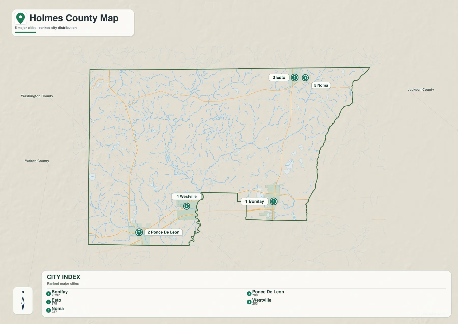
Ponce de Leon and Westville are both west of Bonifay, but they are not the same reference point. Ponce de Leon is associated with the SR 81 and US 90 junction and the western I-10 approach. Westville is farther east along the US 90 corridor and close to the Choctawhatchee River. That river position matters because a trip toward Bonifay must use an actual crossing rather than the shortest line on a map.
Esto and Noma are even more detached from the southern highway corridor. Their proximity to the Alabama line gives them a different travel pattern from Bonifay. Community names such as Bethlehem and Poplar Springs are unincorporated and should be distinguished from the five incorporated municipalities shown on the city map. A mailing place name or a familiar local community label is not enough by itself to establish municipal jurisdiction.
For general navigation, the city map works best as a second layer after the road map. First identify which of the five incorporated places is closest to the destination. Then switch to the county map to find the numbered route that actually reaches that area. This two-step approach is especially helpful in the northern rural sections, where local roads are widely spaced and a town name may cover a broad mailing area.
The Choctawhatchee River is the county’s clearest natural divider
The terrain-and-water map is dominated by the Choctawhatchee River running through western Holmes County. Numerous smaller streams feed the drainage network, and the map labels Sandy Creek, Wrights Creek, Pea River, and several smaller water bodies. Compared with the road map, this view explains why parts of the west do not connect to Bonifay through a simple rectangular road grid. River crossings and lowland areas shape the usable routes.
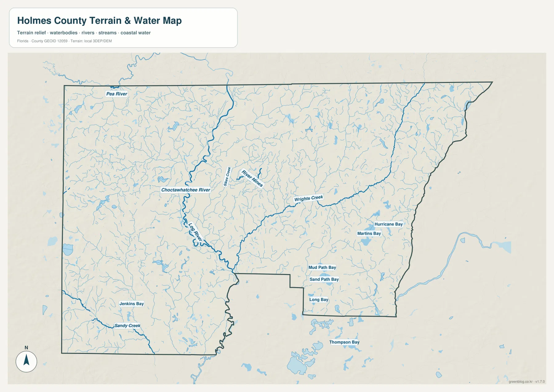
Several labels on the map—Hurricane Bay, Martins Bay, Mud Path Bay, Sand Path Bay, Long Bay, and Thompson Bay—show that the county contains many named wet or water features beyond the main river. These labels should be treated as geographic references, not as a flood-zone layer. The water map does not establish legal shoreline boundaries, parcel limits, or the extent of a FEMA flood hazard.
Ponce de Leon Springs provides a useful example of why water features should be kept separate. Florida State Parks describes two underground flows combining at the main spring, with discharge of about 14 million gallons per day. The clear spring run then meets the darker water of Sandy Creek. The state park lies south of the town of Ponce de Leon and north of I-10; it is not a landing on the main Choctawhatchee River.
Holmes Creek creates another naming trap. It is a stream in the broader Choctawhatchee basin, not another name for Holmes County. The water-management area extends across county lines, so watershed geography, mailing addresses, and county jurisdiction can point to different boundaries. Anyone researching a river access site or rural parcel should verify the actual county rather than relying on the word “Holmes” in a feature name.
How to read a rural Holmes County address from the maps
A useful way to narrow down a rural location is to record three things: the nearest numbered road, the nearest incorporated place, and the side of the Choctawhatchee River. A location near SR 79 and Bonifay belongs to a different travel pattern from an address near SR 81 and Ponce de Leon, even if both are described broadly as being in Holmes County. In the northeast, SR 2 and the Alabama line become stronger clues than the interstate.
Interstate exits should also be read as access points rather than town locations. Exit 112 at SR 79 serves the Bonifay approach, while exit 96 at SR 81 serves the Ponce de Leon side of the county. It also notes that exit 104 at CR 279 is on the Caryville side in Washington County. A route to Westville may sometimes use that nearby interchange, but doing so involves the adjacent county and a Choctawhatchee crossing.
The same distinction applies to land and flood research. Holmes County’s official guidance separates Future Land Use information, parcel mapping, and FEMA flood information. The maps on this page can place a property within the broader road, town, and water setting, but they do not replace the authoritative layer needed for an allowed-use decision, parcel boundary, or flood-zone determination.
Choose the map that matches the question you are asking
- County map: best for county limits, neighboring jurisdictions, Bonifay, major roads, and the overall settlement pattern.
- City map: best for comparing where the five incorporated places sit relative to one another.
- Water map: best for the Choctawhatchee River, named creeks, and smaller water features labeled on the map.
- High-resolution use: choose the ZIP archive when you need the original JPG versions for printing or closer viewing.
The archive contains three high-resolution JPG files matching the three body maps. No elevation map is included here, so the download contains only the county, city, and water maps.
Frequently Asked Questions
Where is Bonifay in relation to I-10?
Bonifay is north of I-10 on SR 79 rather than directly on the freeway. Exit 112 at SR 79 is the main interstate approach to Bonifay, after which the route continues north toward US 90 and the county seat.
Can the water map be used as a Holmes County flood map?
No. It shows rivers, creeks, and other named water features for geographic reference. A flood-zone decision requires the current FEMA flood information or other official hazard mapping intended for that purpose.
Are Holmes Creek and Holmes County the same geographic area?
No. Holmes County is an administrative jurisdiction, while Holmes Creek is part of the Choctawhatchee drainage system. The watershed and management area can extend into neighboring counties, so the similar names should not be treated as matching boundaries.
Map File Information
The ZIP archive contains the high-resolution JPG versions of the Holmes County county, city, and water maps shown on this page.
- Included Files: 3 high-resolution JPG maps
- File Type: ZIP
Related Maps
- Arcadia Roads and Peace River | DeSoto County Florida Map
- Baker County Florida Map
- Blountstown, SR 20, and the Apalachicola River | Calhoun County Florida Map
Sources
- U.S. Census Bureau QuickFacts — Holmes County
- Holmes County government — county administration
- Holmes County government — future land use, parcels, and FEMA flood guidance
- Florida State Parks — Ponce de Leon Springs
- Northwest Florida Water Management District — Choctawhatchee River and Holmes Creek
- Florida Department of Transportation — official transportation map
Green Map creates custom-edited map images using open geographic data sources such as geoBoundaries, Natural Earth, OpenStreetMap, and government open data. These maps are edited visual materials, not raw data files, and are provided for education, documents, presentations, and graphic reference.