A Hillsborough County Florida Map is most useful when it shows more than Tampa alone. Tampa occupies the western side near Tampa Bay, Temple Terrace sits a short distance to the northeast, and Plant City anchors the eastern side near the Polk County line. Between and around those cities are large communities such as Brandon, Riverview, Thonotosassa, Apollo Beach, Ruskin, and Sun City Center. The maps on this page help place those names in relation to the county boundary, major roads, rivers, and the bay, and the high-resolution A3 JPG files are available together in a ZIP farther down the page.
The county stretches from a complicated tidal shoreline on the west to a broad inland boundary on the east. That contrast matters. Travel toward Pinellas County depends on crossings over water, while travel toward Plant City and Polk County follows long land corridors such as I-4. The river network adds another layer, especially around the Hillsborough and Alafia systems, so viewing the general, city, and water maps together gives a clearer picture of how western urban Tampa connects with the county’s eastern and southern communities.
Table of Contents
Where Hillsborough County sits around Tampa Bay
Hillsborough County lies on the inner side of Tampa Bay in west-central Florida. Pasco County is to the north and Polk County to the east, while Manatee County borders the south and a short Hardee County boundary reaches the southeast. Pinellas County is directly across the water on the west. This arrangement is easy to miss on a road-only view because the bay separates places that look close in a straight line but require a bridge or causeway for normal vehicle travel.
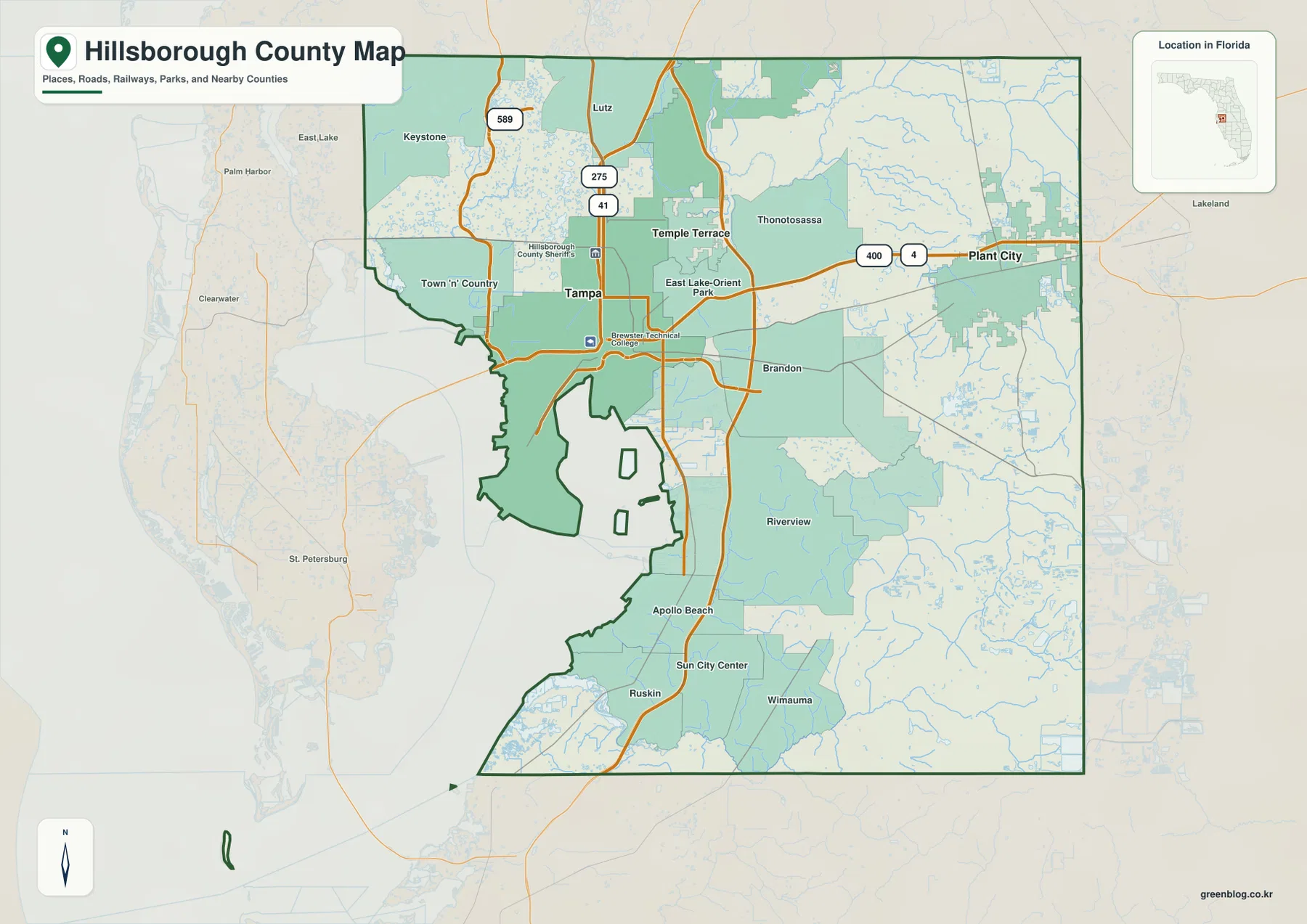
On the general county map, Tampa is the dominant western reference point and Plant City is the clearest eastern one. I-4 runs across the county toward Plant City, while I-75 forms a strong north-south line through the eastern suburbs. I-275 serves central and northern Tampa, and roads such as US 41, US 301, and SR 589 provide additional orientation. The map also labels Lutz, Keystone, Town ‘n’ Country, Thonotosassa, East Lake-Orient Park, Brandon, Riverview, Apollo Beach, Ruskin, Sun City Center, and Wimauma, which makes it easier to see how the county extends well beyond the City of Tampa.
The shape of the county is also informative. The north and east sides are comparatively simple land boundaries, but the west and southwest edges bend around bays, river mouths, and tidal shoreline. That is why western Hillsborough does not behave like a rectangular county on the ground. Waterfront neighborhoods, port areas, airport access, and routes toward Pinellas County all depend on the geography of Old Tampa Bay and Tampa Bay.
Tampa, Temple Terrace, and Plant City form different anchors
The city-connection map reduces the county to three incorporated city anchors: Tampa, Temple Terrace, and Plant City. Tampa is the hub on the west. Temple Terrace appears just northeast of it, and Plant City is much farther east. The map includes approximate straight-line reference distances of about 6 miles from Tampa to Temple Terrace and about 21 miles from Tampa to Plant City, which is useful for understanding relative spacing even though actual driving distances vary by route.
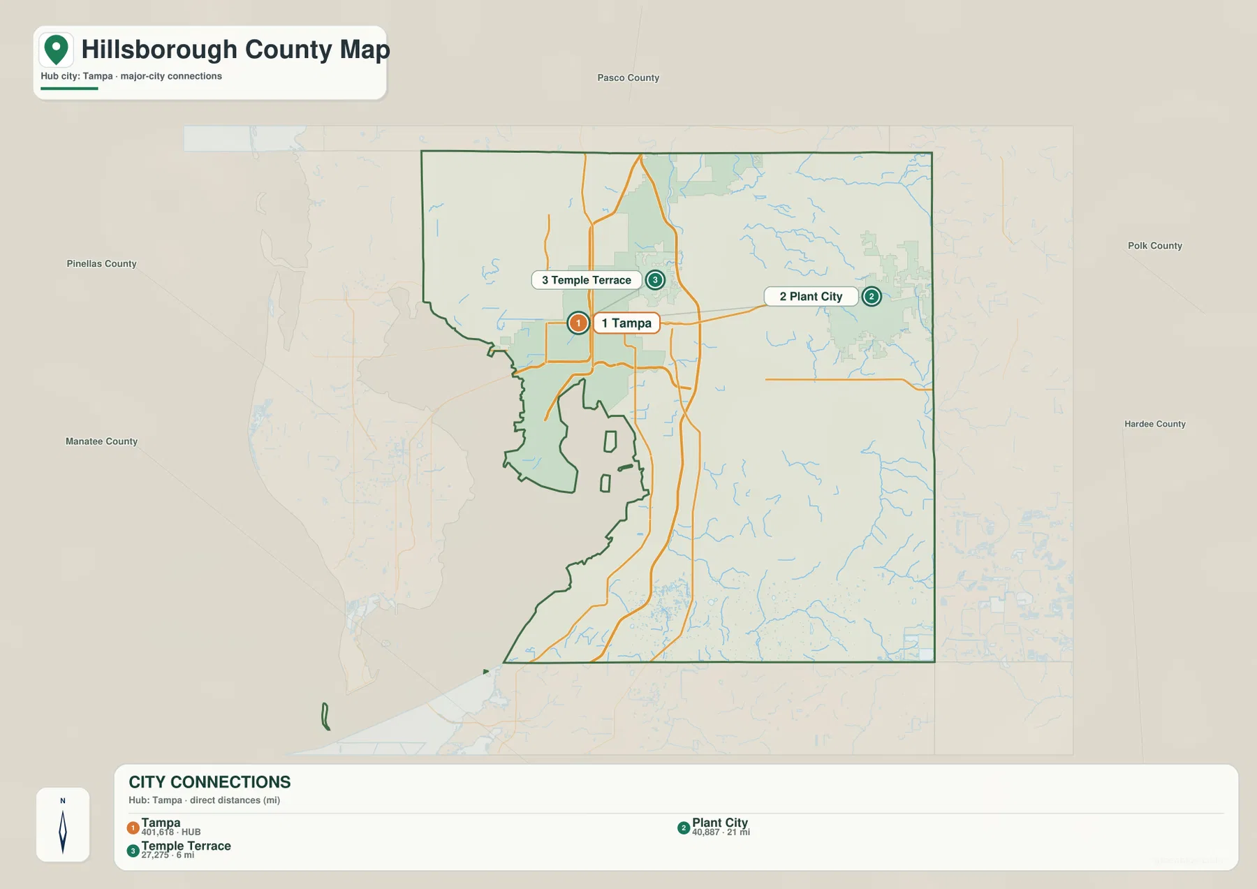
Temple Terrace is small in area compared with Tampa, but its location is useful when reading the northeastern part of the urban area near the Hillsborough River. Plant City has a different role. It is a separate eastern city near the Polk County boundary, reached most directly from Tampa along the I-4 corridor. The land between Tampa and Plant City is not empty suburban space; communities such as Seffner, Dover, Mango, and Thonotosassa help form the transition between the two ends of the county.
Brandon and Riverview often look city-like on regional maps because they are large population and commercial centers, but they are not incorporated cities like Tampa, Temple Terrace, and Plant City. Much of Hillsborough County is unincorporated, so postal place names, Census place names, and municipal limits do not always match. A person can therefore have a Tampa mailing address without being inside Tampa city limits. For property, permitting, zoning, or service questions, the reference maps here should be paired with the county’s current boundary or address tools.
Road corridors explain how the county is connected
I-4 is the most obvious east-west route for reading the map. It leaves the Tampa area and continues through the northern side of Plant City toward Central Florida. I-75 crosses it east of central Tampa and continues south past the Brandon and Riverview areas. I-275 is more closely tied to central and north Tampa, while US 301 runs through the eastern side of the developed area and US 41 follows a more westerly route toward the industrial and coastal communities south of Tampa.
Those roads help separate places that can otherwise blur together on a metropolitan map. Brandon is oriented around the SR 60 and I-75 area east of Tampa. Riverview extends farther south around US 301 and I-75. Apollo Beach is closer to Tampa Bay, while Ruskin and Sun City Center mark the southern part of the county. Wimauma lies farther inland to the southeast. Looking at those names with the road network makes the county’s western, central, and southern subareas easier to distinguish.
The west side works differently because water controls access. Town ‘n’ Country and Tampa International Airport are close to Old Tampa Bay, and travel toward Pinellas County depends on the bay crossings rather than a continuous western land boundary. A straight-line view can make Clearwater or St. Petersburg appear immediately adjacent to Tampa, but the practical route has to follow a bridge corridor. Eastbound travel toward Plant City does not have the same constraint, which is one reason I-4 stands out so clearly on the county map.
The river network changes the map south and east of Tampa
The water map shifts attention away from roads and toward the natural lines crossing the county. The Hillsborough River enters the northeastern part of the county and continues toward Tampa, where it reaches Hillsborough Bay. Palm River appears east of Tampa, while the Alafia system is prominent farther south. The map labels the South Prong Alafia River in the eastern interior and shows a dense network of smaller tributaries feeding westward. Near the southern edge, the Little Manatee River provides another strong water feature close to the Manatee County boundary.
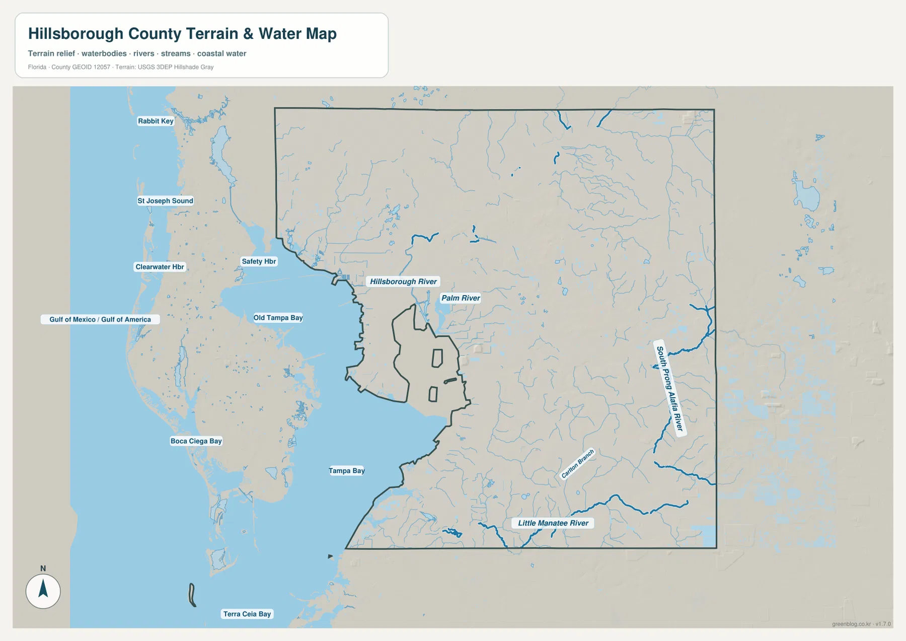
The western water labels provide useful regional context. Old Tampa Bay lies northwest of central Tampa, and Tampa Bay opens to the south. The map also shows St Joseph Sound and Boca Ciega Bay beyond the county to the west and Terra Ceia Bay farther south. These labels are outside the county boundary, but they help explain the larger coastal setting and why the county’s west side has such an irregular outline.
The Alafia system is especially helpful for understanding the southeast. Communities around Lithia, Riverview, and Gibsonton sit along different parts of the river corridor, while Apollo Beach lies closer to the bay. A place may look nearby in a broad regional view yet require a different road approach because a river, tidal creek, or wet area lies between the two points. The Little Manatee River performs a similar orienting role farther south, marking a distinct natural corridor below the main Riverview and Apollo Beach area.
Choosing the right map for the question
For a first look at Hillsborough County, start with the general county map. It combines the boundary, major roads, nearby counties, and many recognizable place names, so it is the best overview for locating Tampa, Plant City, Brandon, Riverview, and the southern communities. The city map is intentionally simpler and works well when the main question is how Tampa, Temple Terrace, and Plant City relate to one another. The water map is better when rivers, bays, or the difference between coastal and inland locations matters.
The maps can be useful for classroom material, travel orientation, local presentations, printed reference sheets, or a quick visual check before opening a more technical GIS viewer. They are not substitutes for parcel boundaries, legal zoning, flood-insurance determinations, or official evacuation instructions. If the question involves a specific property, permit, emergency zone, or regulatory boundary, use the appropriate Hillsborough County or state source after getting oriented with the reference map.
Frequently Asked Questions
Are Brandon and Riverview part of the City of Tampa?
No. Brandon and Riverview are major communities in Hillsborough County, but they are not incorporated into the City of Tampa. They are useful labels on a county map because they identify large developed areas east and southeast of Tampa. For an exact municipal or service boundary, use the county’s current GIS or address tools rather than relying on the mailing city name.
Which road is the easiest reference between Tampa and Plant City?
I-4 is the clearest county-wide reference. It runs east from the Tampa area toward Plant City and continues into Central Florida. Local trips may use US 92, SR 60, or other roads depending on the starting point, but I-4 is the easiest line to find first when comparing the two cities on the map.
Which waterways are most useful for orienting the county?
The Hillsborough River is the key river for the northeastern and Tampa portions of the county. The Alafia River system is more useful around the southeast and Riverview area, and the Little Manatee River provides a strong reference farther south. On the coast, distinguishing Old Tampa Bay from Tampa Bay also makes the location of Tampa and the southern shoreline easier to understand.
Sources and reference data
For official local boundaries and GIS layers, see the Hillsborough County GeoHub and the county government’s county profile and incorporated-city information. Statewide road context is available from the Florida Department of Transportation official transportation map.
For watershed context, the Southwest Florida Water Management District provides information on the Alafia River watershed and the headwaters and course of the Hillsborough River. These reference maps are intended for general orientation; current official sources should take priority for regulatory, parcel, flood, or emergency decisions.
Map File Information
The high-resolution versions are packaged as three A3 JPG maps in one ZIP. The archive is named hillsborough_county_florida_3_map_jpg.zip and is suitable for printing or keeping as an offline reference.
- File Type: ZIP containing three high-resolution A3 JPG files
Related Maps
- Arcadia Roads and Peace River | DeSoto County Florida Map
- Baker County Florida Map
- Blountstown, SR 20, and the Apalachicola River | Calhoun County Florida Map
Green Map creates custom-edited map images using open geographic data sources such as geoBoundaries, Natural Earth, OpenStreetMap, and government open data. These maps are edited visual materials, not raw data files, and are provided for education, documents, presentations, and graphic reference.