Download the Highlands County Map A3 JPG ZIP from this page and use the same reference, city, and terrain-and-water maps while reading the guide below. Highlands County is easiest to understand as two contrasting areas: Avon Park, Sebring, and Lake Placid line up along U.S. 27 on the western Lake Wales Ridge, while the land east of that corridor opens toward Lake Istokpoga, creeks, wetlands, pasture, and managed areas near the Kissimmee side of the county. The downloadable files match the maps shown in the article and are sized for high-resolution A3 output.
For a first look, use U.S. 27 as your anchor. Avon Park is the northern incorporated city, Sebring is the county seat farther south, and the Town of Lake Placid lies farther down the same general corridor. Lorida does not continue that line; it sits east of Sebring along U.S. 98 near the northeastern side of Lake Istokpoga. That one distinction prevents many of the common location mistakes that come from reading only place names without the roads and lakes around them.
The package contains three map files. The county reference map combines the boundary, major roads, place names, parks, and nearby counties. The city map simplifies the county into a Sebring-centered city index with Avon Park and Lake Placid. The terrain-and-water map brings Lake Istokpoga, Lake Jackson, the surrounding creeks, and broad relief to the foreground. They describe the same county from different angles, so the most useful starting file depends on whether your question is about travel, settlement, or water.
Table of Contents
The county changes quickly from the U.S. 27 ridge to the eastern basin
The western side of the county map is where most visitors will first recognize the local pattern. U.S. 27 runs through Avon Park, Sebring, and Lake Placid, with developed areas and numerous lakes packed much more closely together than they are in the east. The route makes the three communities look almost like one long corridor, but their municipal boundaries are separate and substantial unincorporated land lies between and around them. Moving east from that corridor, the map becomes noticeably less urban and much more water-oriented.
Avon Park sits close to the Polk County line. Sebring occupies the middle of the ridge chain and serves as the county seat, with Lake Jackson immediately shaping the city’s local geography. Lake Placid lies farther south among a cluster of lakes. Together, those places provide a practical north–central–south frame for the county. Once that frame is clear, eastbound routes such as U.S. 98 and the southern SR 70 corridor are much easier to place.
The supplied county map also shows why a simple rectangular description does not fit the whole county. The west and south edges are relatively easy to follow, but the eastern boundary bends through a low, water-rich landscape. Highlands touches Polk, Osceola, Okeechobee, Glades, Charlotte, DeSoto, and Hardee counties. A neighboring county may look close on the page while the practical road connection lies in a completely different direction, so the road network matters as much as the boundary line.
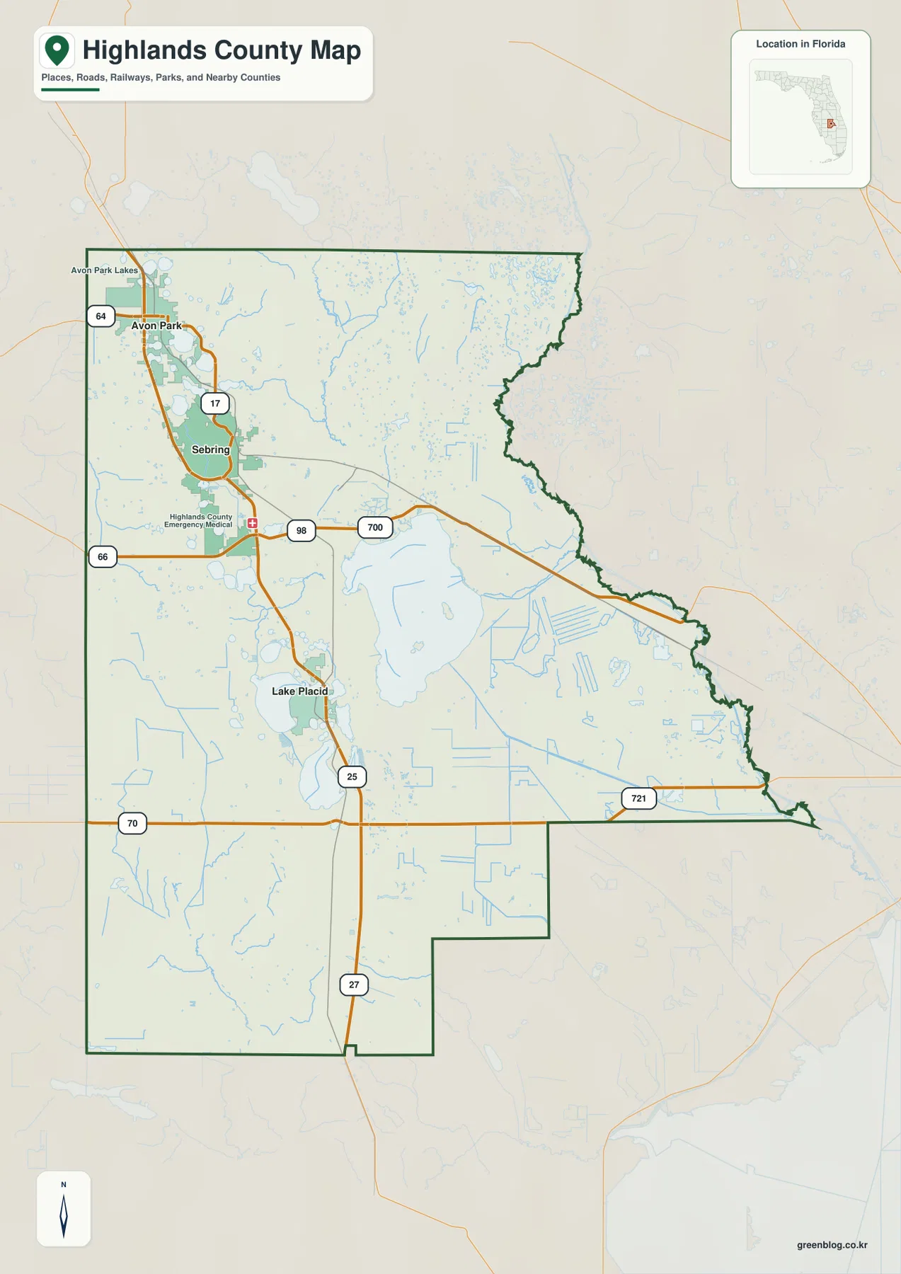
Use this map for orientation rather than turn-by-turn driving. It is very good at answering questions such as whether a destination is north or south of Sebring, whether it sits on the U.S. 27 side of the county or closer to the Lake Istokpoga basin, and which major numbered road is likely to matter. It does not replace current navigation, road-closure notices, parcel mapping, or access rules for managed land.
Sebring, Avon Park, and Lake Placid are close enough to compare but not interchangeable
The city map deliberately strips away most of the county’s detail. Sebring is marked as the hub, Avon Park appears to the north, and Lake Placid appears to the south. In the CITY CONNECTIONS panel, the map prints values of 11,382 for Sebring, 10,057 for Avon Park, and 2,477 for Lake Placid. Because the preview does not state a reference year for those figures, they should be treated as values printed on this supplied map rather than as a current population table.
The same panel shows Avon Park about 7 miles from the Sebring hub and Lake Placid about 14 miles away. That is useful for a quick sense of spacing, especially when all three names appear close together on a statewide map. It is not a promise of exact driveway-to-driveway travel distance. Lakes, local streets, and the precise start and end points can make an actual trip longer, so use the city index for scale and then switch to current road information for navigation.
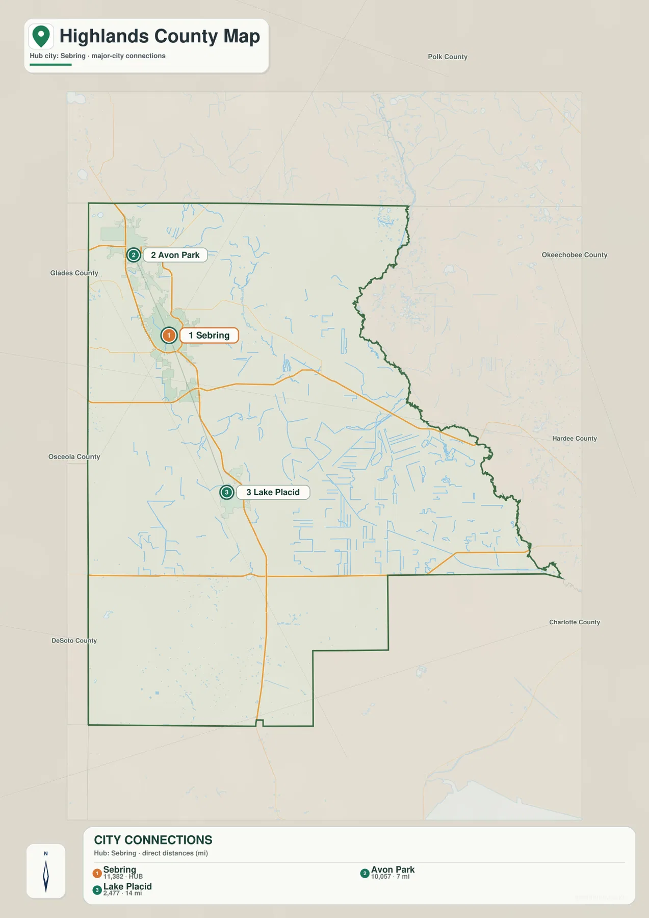
There is also an administrative distinction behind those labels. The retained county materials identify Avon Park and Sebring as cities and Lake Placid as a town. Lorida, by contrast, is an unincorporated community east of Sebring. Postal place names can extend beyond municipal boundaries, so a Sebring or Lake Placid mailing address does not by itself prove that a property is inside that city or town. For taxes, ordinances, elections, or parcel jurisdiction, use official boundary and property records rather than this city map alone.
Lake Istokpoga turns the eastern half into a different kind of map
The terrain-and-water map shifts attention away from roads and toward the county’s lakes and drainage. Lake Jackson is easy to spot near Sebring, while Lake Istokpoga dominates the east-central area. The waterbody labeled Lake Placid appears farther southwest among many smaller lakes. Seeing those names together is a useful reminder that the Town of Lake Placid and the lake named Lake Placid are separate mapped features.
Several named creeks converge around Lake Istokpoga. Arbuckle Creek and Josephine Creek are labeled on the western side of the system, Morgan Hole Creek approaches from the north, and Istokpoga Creek is shown on the east. Fisheating Creek is labeled near the southwestern edge of the county. These features make the water map especially useful for understanding why the eastern half feels less like an extension of the U.S. 27 city corridor and more like a broad network of lakes, creeks, wetlands, and managed land.
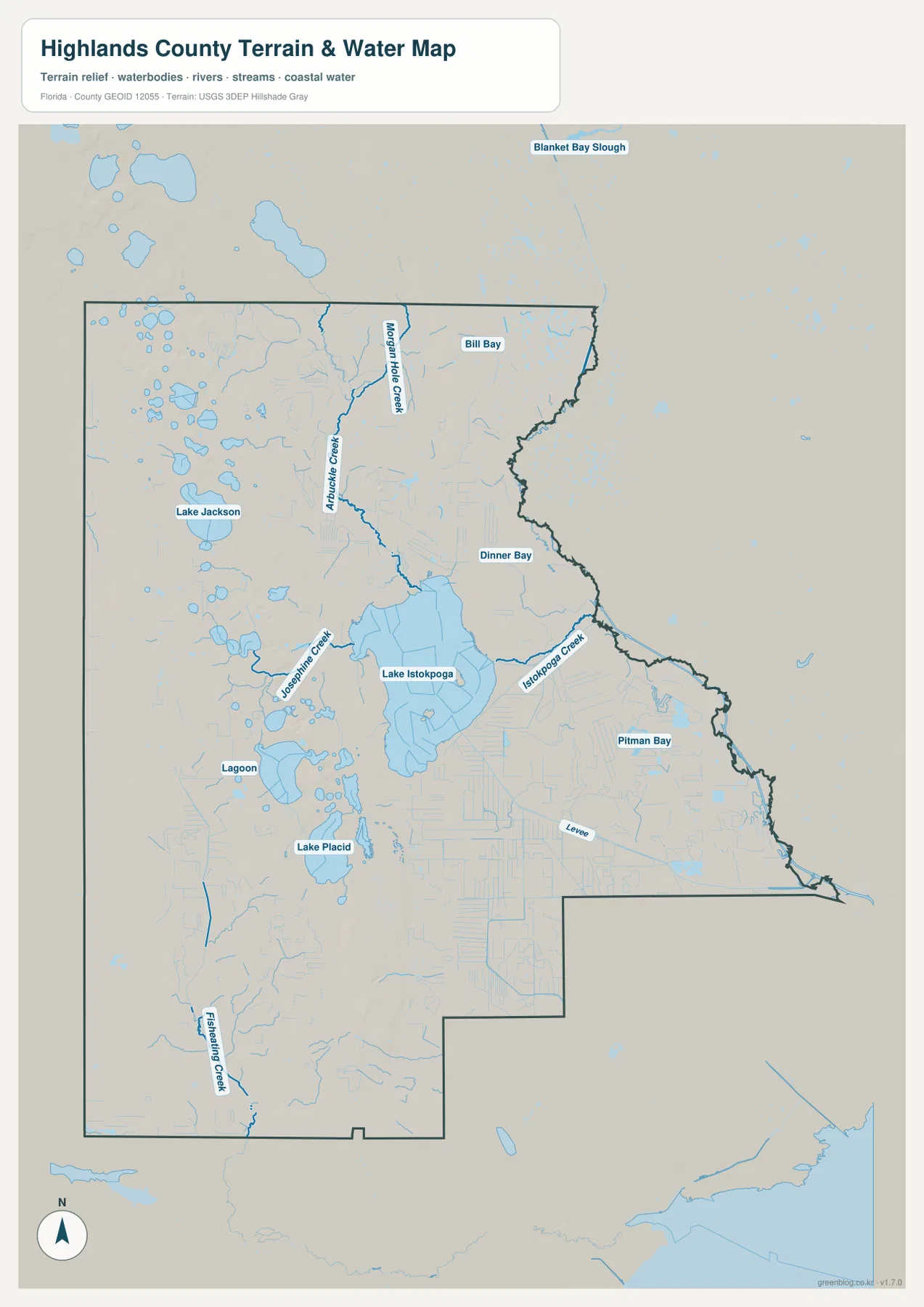
The retained Florida Fish and Wildlife material describes Lake Istokpoga as a 27,692-acre shallow lake. Public access is spread among different shores, and the county materials refer to separate ramp approaches such as Cow House Road, Windy Point, and Boggy Branch. That matters because “Lake Istokpoga” is not one roadside destination. Choosing the wrong shore can create a long detour, so a boat trip or shoreline visit should be planned with the exact ramp name, address, and current operating conditions.
Lines in the eastern basin also require care. A levee, ranch track, or management road can look like a normal route on a small map but may not function as an unrestricted public road. Water level and structure operations can change navigation conditions as well. The county map is useful for orientation, while current access and water-management information should come from the responsible agency before travel.
The main roads make more sense when you match them to the lakes and communities
U.S. 27 is the simplest route to remember because it connects the three ridge communities. SR 17 generally stays closer to older downtown and ridge-lake areas, so it provides a different local reference than the larger U.S. 27 commercial corridor. In Sebring, U.S. 98 becomes the key eastbound route toward Lorida and the Kissimmee side of the county. SR 66 approaches Sebring from the west, while SR 70 crosses the southern part of Highlands between the Arcadia and Okeechobee directions.
Lakes complicate what would otherwise look like a simple grid. Lake Jackson separates parts of Sebring’s downtown side from the U.S. 27 corridor. Around Lake Placid, Lake June in Winter, Lake Huntley, Lake Clay, and other nearby waterbodies force local roads to bend and split. A destination can appear very close across the water while requiring a much longer drive around the shoreline. When planning a local trip, identify the lake shore first and the road number second.
Lorida is a good example of why direction matters. It lies east of Sebring along U.S. 98 rather than south on the U.S. 27 chain. The northeastern Lake Istokpoga area, Hickory Hammock, and canal access points are also reached through the eastern road-and-water network. Travelers who organize the county only as Avon Park–Sebring–Lake Placid can miss that major eastward branch entirely.
Ridge habitat, state park land, and wildlife refuge land have different access rules
The Lake Wales Ridge is an old sandy upland that stands above much of the surrounding plain. The retained reference material links its well-drained soils, sinkhole lakes, scrub, and sandhill habitat to a distinctive natural landscape. The same ridge that helps organize the U.S. 27 communities also supports sensitive habitat, so development, citrus land, lakes, and conservation areas can sit surprisingly close together.
Highlands Hammock State Park west of Sebring is an operated public park with trails and visitor facilities. Lake Wales Ridge National Wildlife Refuge is different: the retained U.S. Fish and Wildlife Service material says the refuge is not generally open to the public because of sensitive plants and animals. A green or protected-looking area on a county map therefore does not automatically mean the public can drive in, park, or hike there. Always identify the managing agency and the actual entrance before visiting.
The same caution applies to sand and dirt roads in the rural east. Highlands County’s retained road-maintenance guidance warns that such routes may be non-county-maintained or private. A navigation app can suggest a shortcut that crosses a gate, ranch track, or management road. County-scale mapping shows where the route lies, but signs, official road status, and current access instructions determine whether you should use it.
Choose the file by the question you are trying to answer
Start with the county reference map when you want the broad relationship among Avon Park, Sebring, Lake Placid, Lorida, the county boundary, and the main numbered roads. It is the most useful single file for general orientation. Switch to the city map when you want a cleaner comparison of Sebring, Avon Park, and Lake Placid without the extra water and road detail. Use the terrain-and-water map when Lake Istokpoga, Lake Jackson, creek names, shoreline orientation, or the eastern basin is the main subject.
The three files also work well as a sequence for a classroom, presentation, or printed handout. The first map establishes the county and its roads, the second simplifies the major incorporated places, and the third explains how much of the county’s shape and movement is influenced by water. The downloadable JPG versions are larger than the web previews and are sized for A3 output, making labels easier to inspect on a large screen or print.
These maps are reference products rather than live operational maps. They should not be used alone to decide current road closures, legal parcel boundaries, flood-insurance status, boating depth, refuge access, or private-road rights. For those questions, combine the map with the latest information from FDOT, Highlands County, FWC, SFWMD, Florida State Parks, or the relevant federal agency.
Frequently Asked Questions
Do I stay on U.S. 27 to travel from Sebring to Lorida?
No. U.S. 27 is the north–south ridge route through Avon Park, Sebring, and Lake Placid. Lorida is east of Sebring along U.S. 98. Trips toward northeastern Lake Istokpoga or the eastern managed basin should be planned around U.S. 98 and the exact facility entrance.
Are the Town of Lake Placid and the lake named Lake Placid the same feature?
No. Lake Placid is the name of an incorporated town and also a nearby waterbody name. The town center, a shoreline address, and other nearby lakes are separate destinations, so confirm the road and waterbody name rather than relying on “Lake Placid” alone.
What files are included in the downloadable ZIP?
The archive contains three high-resolution A3 JPG files matching the county reference map, the city map, and the terrain-and-water map used on this page. They are the larger printable counterparts to the WebP previews in the article.
Map File Information
Download the Highlands County reference map, city map, and terrain-and-water map together as high-resolution A3 JPG files in one ZIP archive.
- Included Files: 3 A3 JPG maps
Related Maps
- Arcadia Roads and Peace River | DeSoto County Florida Map
- Baker County Florida Map
- Blountstown, SR 20, and the Apalachicola River | Calhoun County Florida Map
Sources and official references
This article is grounded in the supplied maps and the official references retained in the rewrite package. Check the latest agency information for population, road status, park operations, boat access, and refuge rules because those details can change after a map is produced.
- U.S. Census Bureau — Highlands County QuickFacts
- Florida Department of Transportation — county general highway maps
- Florida Fish and Wildlife Conservation Commission — Lake Istokpoga
- Florida State Parks — Highlands Hammock State Park
- U.S. Fish and Wildlife Service — Lake Wales Ridge National Wildlife Refuge
Green Map creates custom-edited map images using open geographic data sources such as geoBoundaries, Natural Earth, OpenStreetMap, and government open data. These maps are edited visual materials, not raw data files, and are provided for education, documents, presentations, and graphic reference.