Walker County sits in the far northwestern part of Georgia, where long mountain ridges, narrow valleys, and a cluster of communities near the Tennessee line create a landscape that changes sharply from west to east. LaFayette, the county seat, lies near the middle of the county, while Chickamauga, Rossville, and Lookout Mountain are farther north. The maps on this page show the county boundary, major routes and places, city locations, streams and reservoirs, and the county’s large elevation range. After reviewing the WEBP previews, you can download a ZIP containing four high-resolution A3 JPG maps.
The terrain is one of the easiest ways to understand why Walker County does not look or function like a uniform block. High ground forms a strong band along the western side, with lower valleys immediately to the east. The northern communities are concentrated closer to the state line, while LaFayette is separated from them in the central part of the county. Looking at the four maps together makes those relationships easier to follow than relying on a boundary map alone.
Table of Contents
Roads, places, and the Walker County boundary around LaFayette
LaFayette is the easiest reference point on the general county map. Routes marked 27 and 1 run north and south through the central part of the county, while 193 and 136 provide east-west connections near LaFayette. Farther north, the map labels Chickamauga, Fairview, Fort Oglethorpe, Rossville, Lookout Mountain, Lakeview, and Chattanooga Valley. The distribution is noticeably uneven: the central county has LaFayette as its main hub, while several named communities are packed into the northern end.
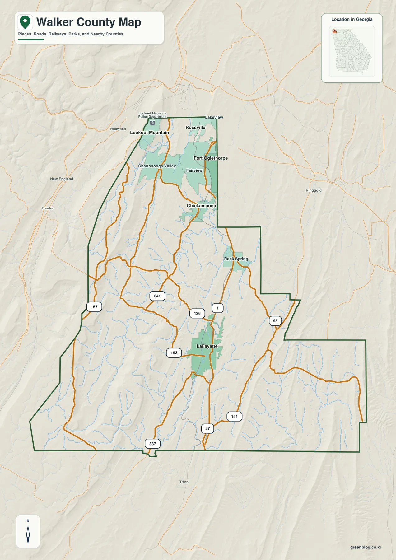
The county outline also helps place Walker County within northwest Georgia. Dade County is shown to the west and northwest, Catoosa County to the northeast, and Whitfield and Gordon counties along the eastern side. Floyd and Chattooga counties appear along the south and southwest. The boundary is not a simple rectangle; on the eastern side it steps inward and outward several times, while the northwestern side follows the long mountain country near Lookout Mountain.
Several additional route numbers appear across the map, including 95, 151, 157, 337, and 341. Their value on this page is not to replace a turn-by-turn road map but to show how different parts of the county connect with LaFayette and the northern communities. The map leaves out many local streets, addresses, and parcel boundaries, so it works best as a county-scale reference for orientation, classroom use, or a report that needs a clear geographic overview.
How LaFayette relates to Chickamauga, Rossville, and Lookout Mountain
The city map strips away many of the smaller labels and focuses on four places. LaFayette is marked as the hub in the central part of Walker County. Chickamauga is north of it, Rossville is farther north and east, and Lookout Mountain is positioned toward the northwestern ridge. The distance panel on the map gives straight-line distances from LaFayette of about 12 miles to Chickamauga and about 18 miles to both Rossville and Lookout Mountain. Those numbers are not driving distances, but they make the separation between the central hub and the northern communities easy to grasp.
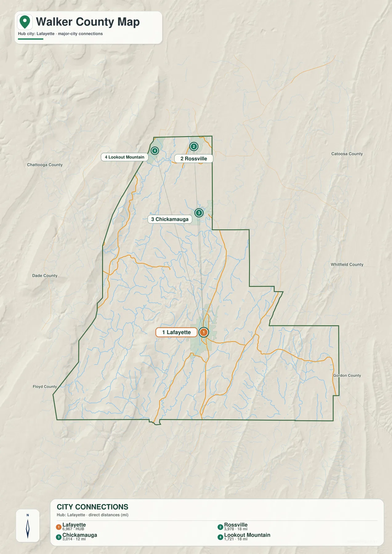
This arrangement is useful because Walker County has more than one obvious area of activity. LaFayette serves as the county seat and a central road junction, yet the map’s northern end contains a tight group of communities near the Tennessee border. Rossville and Lookout Mountain sit near the top of the county, while Chickamauga lies between that northern cluster and LaFayette. A reader planning a local history project or trying to understand place names around Chattanooga can use the city map to see why the northern part of Walker County is geographically distinct from the county-seat area.
The simplified city map should be read alongside the general map rather than as a complete list of settlements. Rock Spring, Chattanooga Valley, Fairview, and other labels visible on the county map are not given the same emphasis here. That is intentional: one map provides a broader set of places and roads, while the other highlights the relationship among the four named communities. Using both avoids the impression that Walker County contains only four populated places.
Chickamauga Creek branches, local reservoirs, and smaller waters
The water map reveals a dense network of streams running through the valleys. Rock Creek and Dry Creek are labeled in the northern part of the county. Chickamauga Creek and W Chickamauga Creek run through the north-central area, while West Chickamauga Creek appears farther southwest. Cane Creek is prominent in the southeastern half, and Chattooga Creek is labeled closer to the southern edge. Rather than one large river cutting across the county, Walker County is shown as a collection of tributaries occupying separate valleys and eventually connecting beyond the map area.
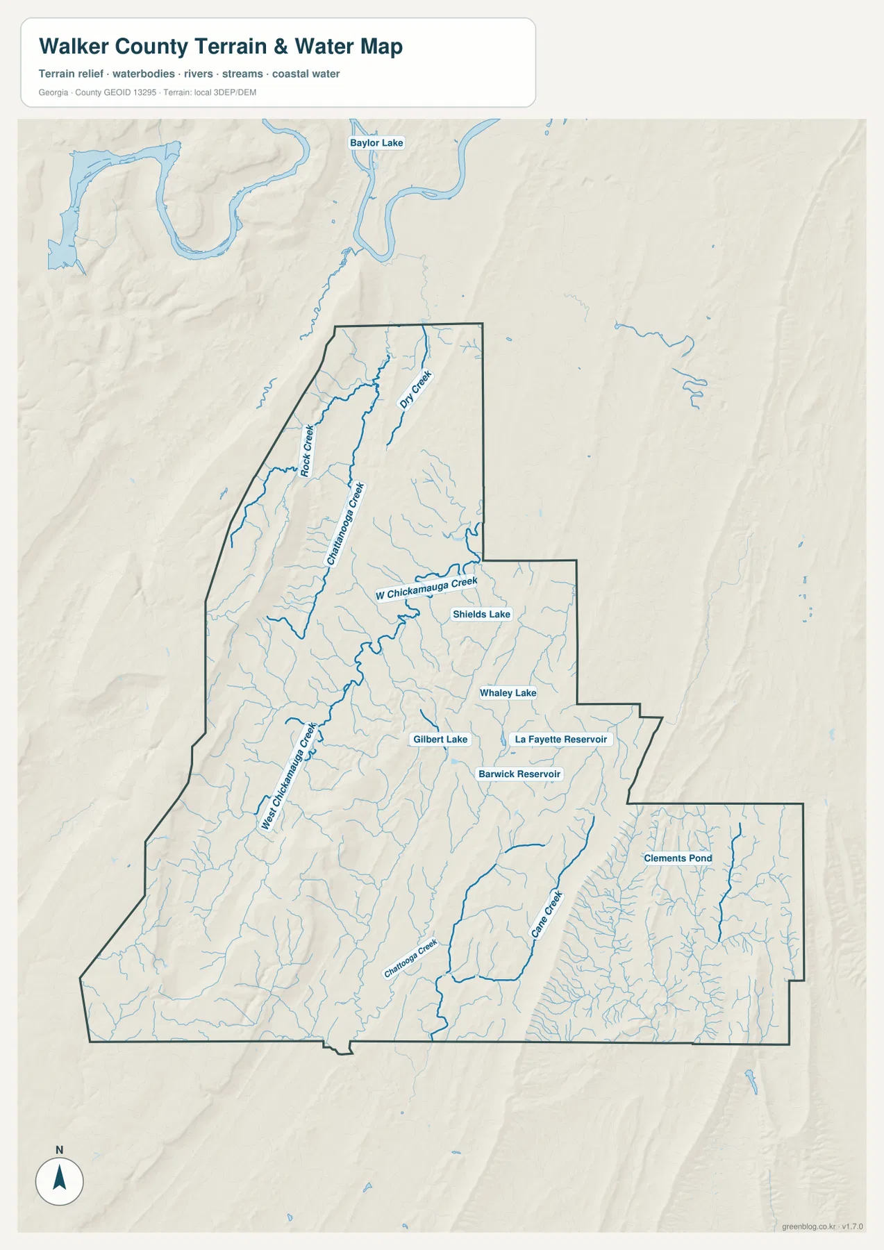
Several smaller lakes and reservoirs are also labeled. Gilbert Lake, La Fayette Reservoir, and Barwick Reservoir sit in the central part of the county, not far from the LaFayette area. Shields Lake and Whaley Lake are farther north and east, while Clements Pond appears in the southeastern section. Baylor Lake is visible beyond the county to the north, providing useful context without implying that it lies inside Walker County. These names make the water map more useful for local orientation than a stream-only diagram would be.
The stream network begins to make more sense when it is compared with the elevation map. Many of the longer channels occupy lower strips between ridges, especially where north-south valleys are clear. This map is not designed to show flood zones, water quality, discharge, or property-level drainage. For those questions, current hydrologic and emergency-management data should be consulted. Here the goal is simpler: identify which waterways and reservoirs are present and see how they are distributed across the county.
A 197–717 meter elevation range shaped by western ridges and lower valleys
Walker County’s elevation map shows one of the strongest terrain contrasts among the county maps in this series. The displayed actual range is about 197 to 717 meters, with a mean elevation of about 331 meters. The western edge forms a long band of higher brown and orange terrain. Lookout Mountain is located in this northwestern high country, and the ridge continues southward as a major visual feature. Immediately east of it, broad green valleys sit much lower, so the change in elevation occurs across relatively short distances.
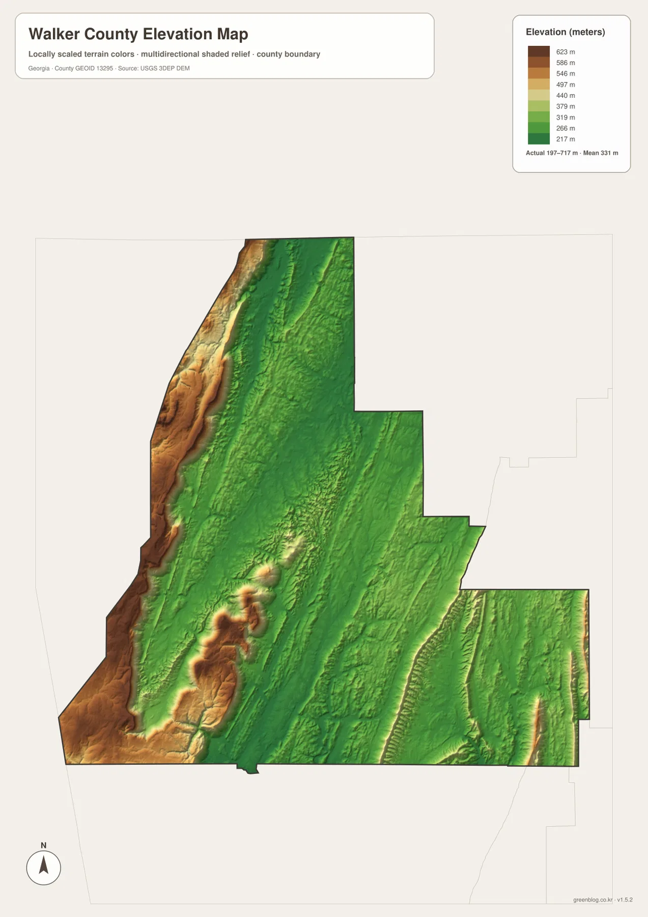
A second high area stands out in the southwestern interior, where several ridges and knobs rise above the surrounding green terrain. The central LaFayette area is generally lower than the western ridge, while the eastern half contains narrower ridges separated by lower ground. The southeastern corner also shows elongated terrain lines rather than a flat plain. In other words, Walker County does not simply slope in one direction; it contains repeated bands of high and low terrain.
That relief helps explain patterns visible on the other maps. Roads and communities are not concentrated only on the highest ground, and many watercourses follow the lower valleys between ridges. The elevation layer should not be used to determine the grade of a particular road or the precise height of an individual property, but it is well suited to explaining why Lookout Mountain occupies such a distinctive setting and why the county’s western side looks so different from the central and eastern valleys.
Choosing the right Walker County map for your project
Use the general county map when you need the boundary, road network, neighboring counties, and a wider set of place names on one page. The city map is better when the task is to explain where LaFayette sits in relation to Chickamauga, Rossville, and Lookout Mountain without extra labels. For waterways, the dedicated water map makes the Chickamauga Creek branches, Cane Creek, reservoirs, and smaller lakes much easier to find. The elevation map is the clearest choice for showing the county’s western mountain ridge, lower valleys, and broad 197–717 meter range.
- County map: boundary, nearby counties, LaFayette, northern communities, and major routes
- City map: direction and straight-line distance from LaFayette to Chickamauga, Rossville, and Lookout Mountain
- Water map: Chickamauga Creek branches, Cane Creek, reservoirs, lakes, and smaller streams
- Elevation map: western high ridges, lower valleys, and the county’s approximately 197–717 meter elevation range
The WEBP images in the article are lighter previews intended for on-page viewing. If you plan to print a map or inspect labels at a larger size, use the JPG files in the ZIP instead. These maps are geographic reference products, not legal survey documents, parcel maps, flood determinations, or navigation instructions. When a project depends on exact boundaries, current road conditions, hydrology, or property information, check the appropriate official source in addition to these overview maps.
Frequently Asked Questions
Are LaFayette, Chickamauga, Rossville, and Lookout Mountain all close together?
No. LaFayette is in the central part of the county, while the other three places are farther north. The city map shows Chickamauga about 12 straight-line miles from LaFayette and both Rossville and Lookout Mountain about 18 miles away. The northern communities are therefore more tightly grouped with one another than with the county seat.
What is the most noticeable terrain feature on the elevation map?
The strongest contrast is the long high ridge along the western side next to much lower valleys. The map’s actual elevation range is about 197 to 717 meters, so the difference between the high western terrain and the central low ground is substantial and easy to see.
Which waterways are easiest to identify on the water map?
Chickamauga Creek and W Chickamauga Creek are useful starting points in the northern and central portions of the county. Rock Creek, Dry Creek, Cane Creek, La Fayette Reservoir, Barwick Reservoir, and several smaller lakes can then be located around them to build a fuller picture of the county’s drainage network.
Sources and reference data
For official boundary, hydrology, elevation, and county background information, the following sources provide useful companion material to the maps on this page.
- U.S. Census Bureau QuickFacts for Walker County — county background statistics
- New Georgia Encyclopedia: Walker County — county history and local context
- U.S. Census Bureau TIGER/Line Shapefiles — boundary and road reference data
- USGS National Hydrography — streams and waterbody reference data
- USGS 3D Elevation Program — elevation and terrain reference data
Map File Information
The ZIP includes four Walker County maps as high-resolution A3 JPG files: county, city, water, and elevation. They can be used for printing, classroom geography, local research, reports, and presentations.
- Included Files: County map, city map, water map, elevation map
- File Type: ZIP containing four high-resolution A3 JPG files
Related Maps
Green Map creates custom-edited map images using open geographic data sources such as geoBoundaries, Natural Earth, OpenStreetMap, and government open data. These maps are edited visual materials, not raw data files, and are provided for education, documents, presentations, and graphic reference.