Upson County sits in west-central Georgia, where Thomaston forms the clearest road and settlement hub while the Flint River traces the county’s western side. The maps on this page are designed to show more than a boundary: they separate the county’s road pattern, the positions of Thomaston and Yatesville, its dense network of creeks and small reservoirs, and the strong elevation contrast between the higher northwest and the lower southern terrain. You can review the WEBP previews below and download all four maps together as high-resolution A3 JPG files in one ZIP archive.
The four views are especially useful together because Upson County changes noticeably from one side to another. Thomaston is near the middle of the county and connects several major routes. Yatesville is well to the northeast, close to the county edge. The Flint River is not centered on Thomaston but lies along the western side, while smaller streams cross much of the interior. Elevation ranges from roughly 100 to 388 meters on the terrain map, with the roughest and highest ground concentrated in the northwest. Those relationships are easy to miss on a single general-purpose map.
Table of Contents
Thomaston sits near the center of the county network
The county reference map places Thomaston slightly west of center and shows why it works as the main orientation point. Roads converge on the city from the north, east, south, and west, then continue toward neighboring counties. Route numbers 19 and 36 are shown through the Thomaston area, while the road marked 3 runs northward from the city. The map is not intended to replace a street-level navigation service, but it makes the county’s basic travel directions easy to understand without the clutter of every local road.
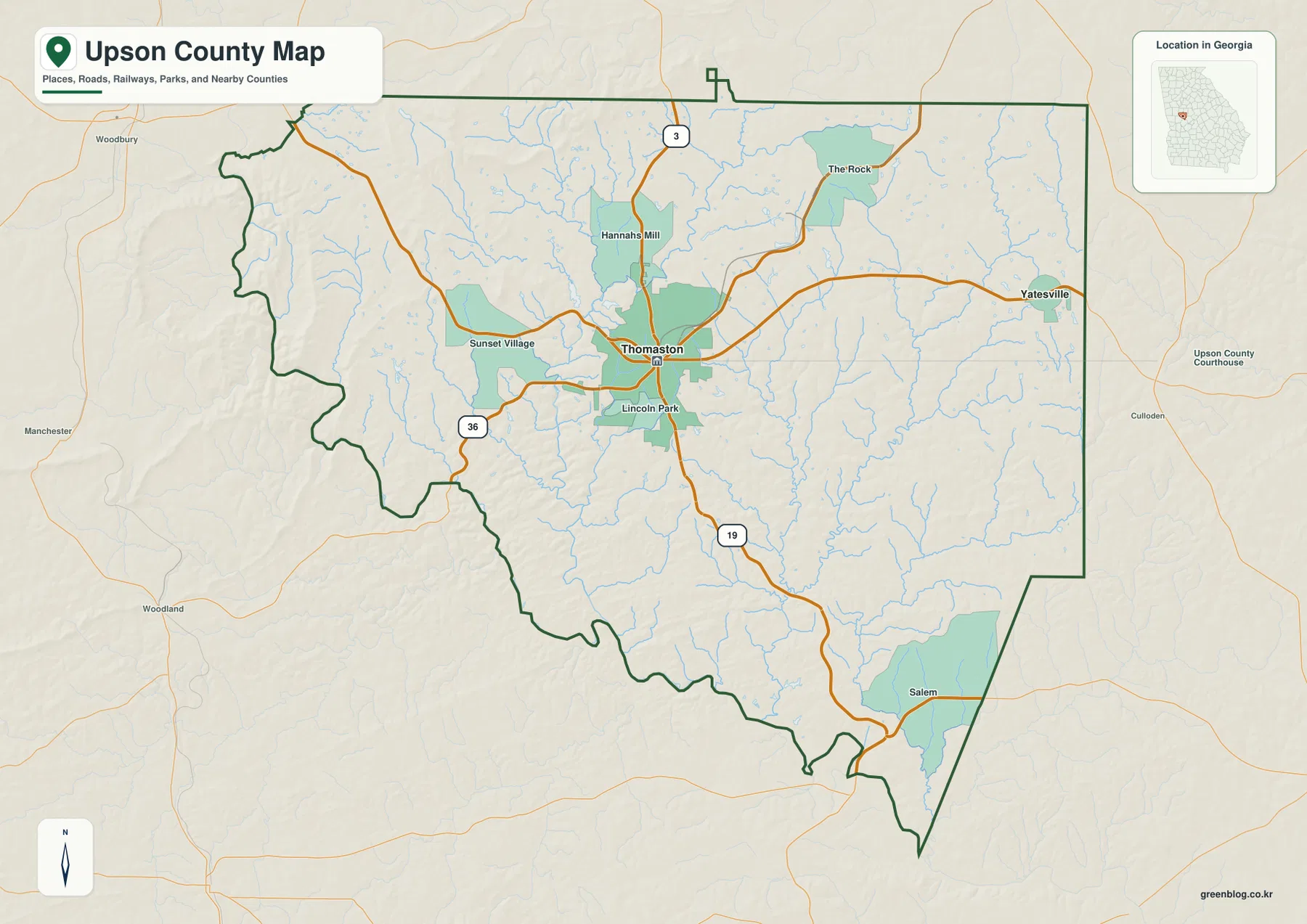
Several smaller named places help give the central part of the county more context. Lincoln Park and Sunset Village appear close to Thomaston, Hannahs Mill is just to the north, and The Rock is farther northeast. Salem is labeled in the southeastern portion of the county. These labels are useful because they show that settlement is not distributed evenly: the most visible concentration is around Thomaston, while other communities and named areas are separated by larger rural stretches.
The surrounding county labels also make Upson’s regional position clearer. Lamar County and Pike County are to the north, Crawford County and Monroe County lie to the east, and Talbot, Meriwether, and Taylor counties appear around the western and southern sides. The western and southern boundary is noticeably more irregular than much of the east. That shape matters when the map is compared with the water layer, because parts of the western edge closely follow the landscape around the Flint River and its tributary valleys.
Thomaston and Yatesville occupy very different parts of Upson County
The city map strips away many secondary labels and focuses on the two incorporated places highlighted in the county data. Thomaston is the dominant center, positioned close to the middle of Upson County, while Yatesville sits near the northeastern boundary. Their separation is obvious even at a quick glance. Someone using the map for a school project, local history page, or county overview can explain the county seat and the smaller northeastern city without having to sort through dozens of minor place names.
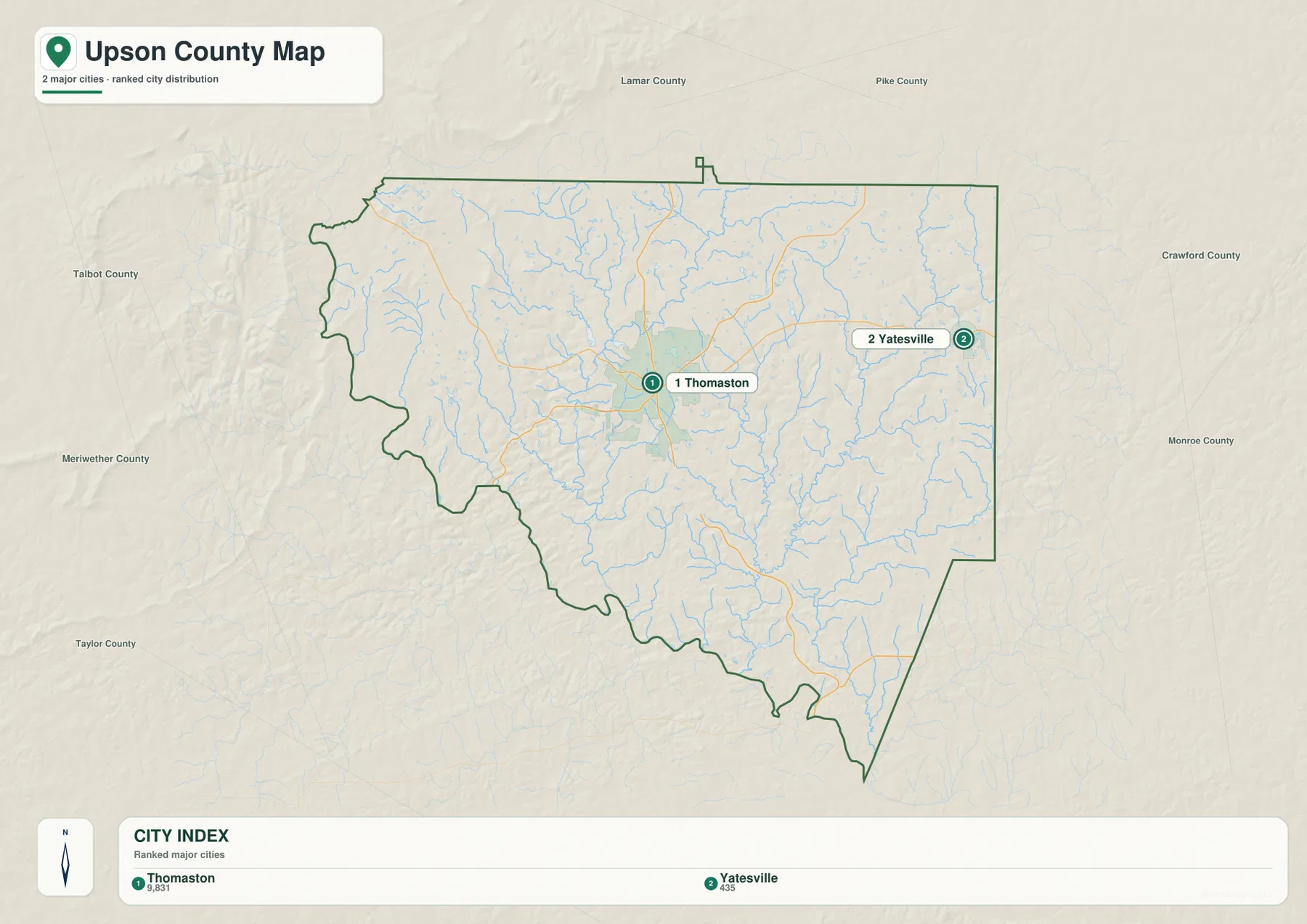
The city index printed on the map also shows a large difference in the values attached to the two places: 9,831 for Thomaston and 435 for Yatesville. These are the city-size figures included in the map dataset and are best read as context for the map rather than as a substitute for a current demographic table. The contrast matches what the road network suggests. Thomaston has several routes feeding into and through it, whereas Yatesville is a much smaller point near the county’s edge.
This simplified city view is useful precisely because it does not try to show every unincorporated community, subdivision, public building, or local street. If the question is “Where is the county seat?” or “How far toward the northeast is Yatesville?”, the map answers quickly. For addresses, parcel boundaries, emergency routes, or detailed municipal limits, a specialized local GIS or navigation map would still be needed.
The Flint River is only one part of a much denser water network
The terrain and water map makes the western Flint River easy to locate, but the interior drainage is just as important to the county’s physical geography. Potato Creek and the Red River are labeled north of the center, while Little Swift Creek, Swift Creek, Tobler Creek, and Auchumpkee Creek run through central and southern areas. Many smaller unnamed branches feed into those channels. The result is a map covered by narrow blue lines rather than a county dominated by one single river corridor.
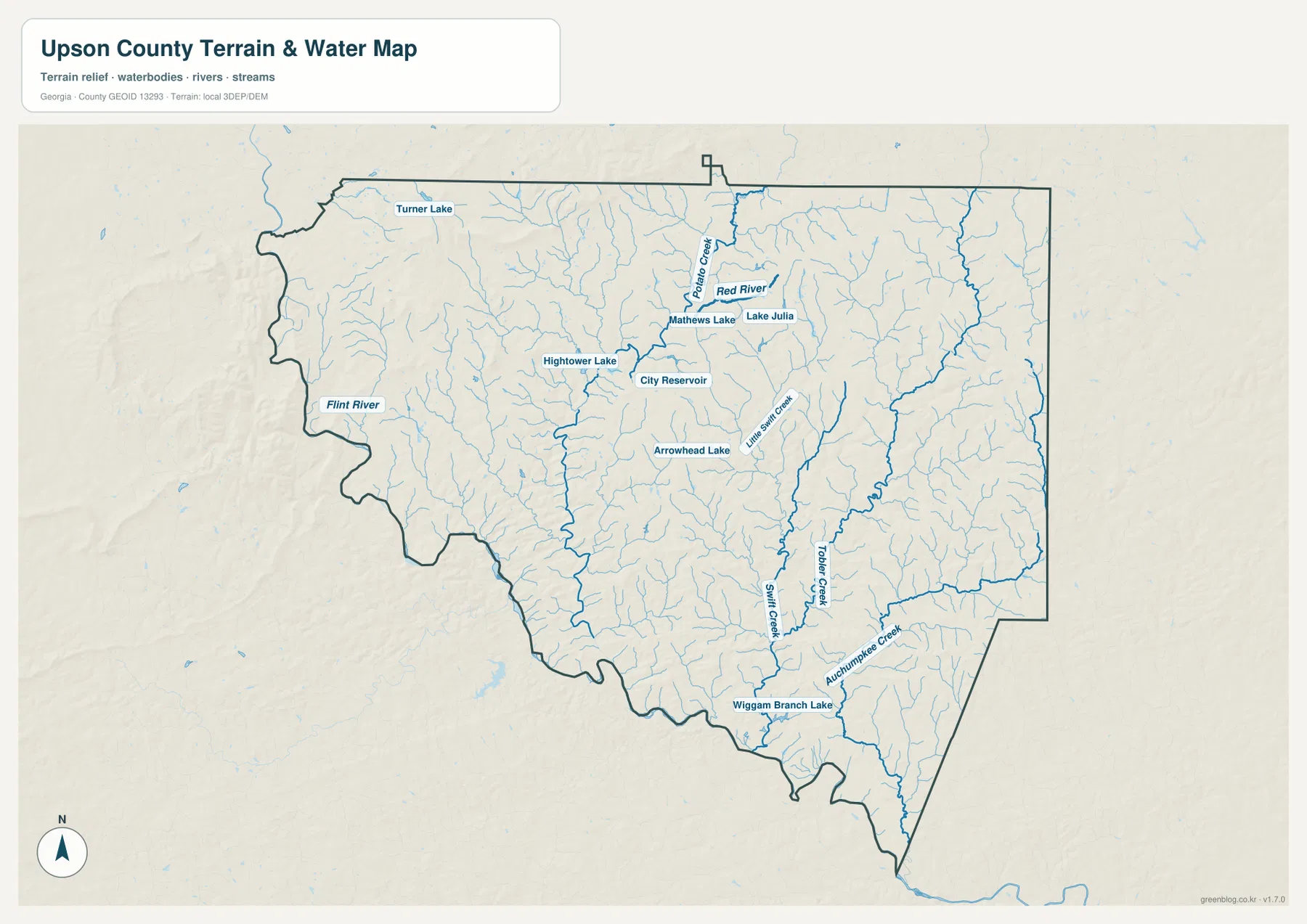
Small lakes and reservoirs add another layer of detail. Turner Lake is labeled in the northwest, while Hightower Lake, Matthews Lake, Lake Julia, City Reservoir, and Arrowhead Lake appear closer to the central part of the county. Wiggam Branch Lake is shown in the south. They are modest features compared with the Flint River, yet their distribution helps explain why a water-specific map can be more useful than a general county map when the goal is to discuss local watersheds, recreation settings, or the relationship between valleys and settlement.
Thomaston itself is not shown as a city sitting directly on the Flint River. Instead, it lies inland among smaller streams and reservoirs, with the major river farther west. This distinction is helpful when describing the county: the Flint River defines an important western reference, but the everyday landscape around the county seat is shaped by a web of smaller drainage lines. In the southeast, larger channels continue toward and beyond the county boundary, making the southern edge another place where water and boundary shape can be compared.
Elevation falls away from the rugged northwest toward lower southern valleys
The elevation map provides the clearest explanation for many of the patterns seen on the water layer. Its printed statistics give an actual range of about 100 to 388 meters, with a mean near 202 meters. The highest terrain appears in the northwest and along parts of the northern side, where closely spaced ridges and valleys create a rougher surface. The south and southeast are generally lower, shown by broader green areas and long low corridors that correspond with stream valleys.
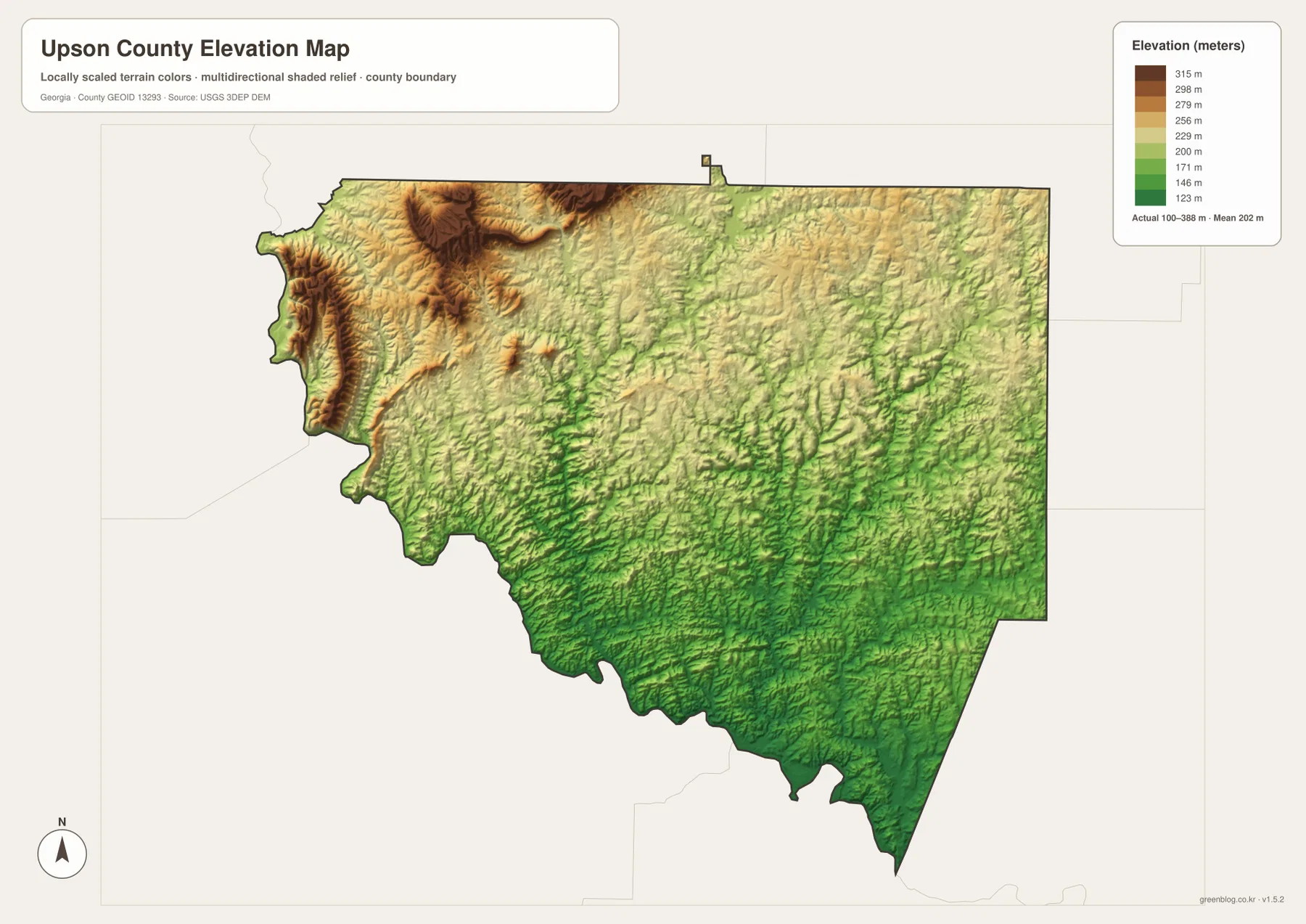
The western edge is particularly varied. Instead of a broad flat strip beside the county line, the map shows repeated ridges and incised valleys, and the northwest contains a compact high area that stands out from the center of the county. Moving southward, the surface becomes lower overall even though small hills and valleys remain. The transition is gradual rather than a single sharp escarpment, which is why the shaded relief is useful: it reveals many small landforms that a simple elevation-number map would flatten into a few broad color bands.
Comparing the elevation and water maps is especially informative. Streams tend to follow the green, lower corridors between ridges, and the branching creek pattern becomes easier to interpret once those valleys are visible. The map should not be used to determine an exact elevation for a house, trail point, or parcel, but it works well for county-scale comparisons. It also helps explain why western and northwestern Upson County can look more rugged while the southern drainage network follows generally lower ground.
Choose the map that matches the question you need to answer
A general county overview is easiest with the county map because it keeps roads, labeled places, the boundary, and surrounding areas in one frame. The city map is cleaner when Thomaston and Yatesville are the only places that need to stand out. For a watershed or environmental discussion, the water map adds the Flint River, named creeks, lakes, and reservoirs. The elevation map is the best companion when the topic is relief, ridge-and-valley terrain, or the contrast between the higher northwest and lower southern areas. Using the views separately keeps each page or presentation from becoming overloaded.
- County map: boundary, neighboring counties, major roads, and the broader position of Thomaston.
- City map: a simple comparison of Thomaston and Yatesville.
- Water map: Flint River, named creeks, reservoirs, and the branching drainage network.
- Elevation map: county-wide relief from roughly 100 to 388 meters and the higher-to-lower terrain pattern.
The images displayed in the article are WEBP previews optimized for the webpage. If you need to zoom in, print a map, or place it in a report or slide deck, use the JPG files from the ZIP rather than saving the preview. These maps are reference graphics, not legal survey documents. Property boundaries, official engineering work, flood-risk decisions, and other high-precision uses should be checked against the latest authoritative datasets.
Frequently Asked Questions
Where is the Flint River in relation to Upson County?
The Flint River is labeled along the western side of the county. Thomaston is farther inland, so the major river is better understood as a western boundary-area feature while smaller creeks and reservoirs are closer to the county’s central settlement area.
How are Thomaston and Yatesville positioned on the city map?
Thomaston is near the center of Upson County and acts as the main road hub. Yatesville is northeast of Thomaston and close to the county’s northeastern edge, so the two cities are clearly separated on the simplified city view.
What is the main elevation difference shown across Upson County?
The map shows an actual elevation range of roughly 100 to 388 meters. The most rugged high ground is concentrated in the northwest and parts of the north, while much of the south and southeast is lower and crossed by stream valleys.
Sources and Reference Data
For current official information or more detailed boundary, hydrography, and elevation data, consult the original agencies and county reference sources below.
- U.S. Census Bureau QuickFacts for Upson County — county statistics and demographic context.
- New Georgia Encyclopedia: Upson County — historical and regional background.
- U.S. Census Bureau TIGER/Line Shapefiles — boundary and transportation reference data.
- USGS National Hydrography — river, stream, and waterbody reference data.
- USGS 3D Elevation Program — elevation and terrain reference data.
Map File Information
The download contains four Upson County maps as high-resolution A3 JPG files: county, city, water, and elevation. The ZIP is suitable for printing, classroom use, reports, presentations, and other location-reference work.
- Included Files: County Map, City Map, Water Map, Elevation Map
Related Maps
Green Map creates custom-edited map images using open geographic data sources such as geoBoundaries, Natural Earth, OpenStreetMap, and government open data. These maps are edited visual materials, not raw data files, and are provided for education, documents, presentations, and graphic reference.