Clay County sits in the far southwestern mountains of North Carolina, with the Georgia state line forming its southern edge and Hayesville near the center of local activity. This is a county that makes more sense when roads, valleys, and streams are viewed together rather than as separate layers. The maps on this page show the county boundary, major road connections, the position of Hayesville, and a detailed network of waterways leading toward the Hiwassee River and Chatuge Lake. High-resolution JPG versions of the supplied maps are also available in the ZIP download near the end of the article.
The county outline is relatively straight along the Georgia border but becomes irregular across the mountain terrain to the north and east. Cherokee County provides the western reference, Graham County lies to the north, and Macon County is shown on the eastern side. Within Clay County, Hayesville and US 64 are the clearest man-made orientation points, while the branching creeks explain why roads and settlements do not follow a simple grid. Reading those features together gives a much better picture of the county than looking at the boundary alone.
Table of Contents
Hayesville, US 64, and the county’s mountain-border layout
The general county map is the best starting point because it keeps the boundary, principal roads, nearby places, and water features in the same view. Hayesville appears a little west of the county’s middle, and US 64 runs east-west through the area before bending through the mountains. Roads become more curved toward the outer parts of the county, a visible reminder that this is not flat grid country. The line along the south is especially useful for orientation because it is the North Carolina-Georgia border, placing Hayesville only a short map distance north of another state.
Several numbered routes meet or pass near Hayesville. The map shows 69 and 175 close to the county seat, while additional numbered roads continue toward the Georgia side. Instead of treating every route as an isolated label, it is more useful to notice how they gather around the central valley and then split toward different mountain gaps. US 64 provides the broad east-west reference. From there, the viewer can follow roads west toward Cherokee County or east toward Macon County without losing the county’s overall shape.
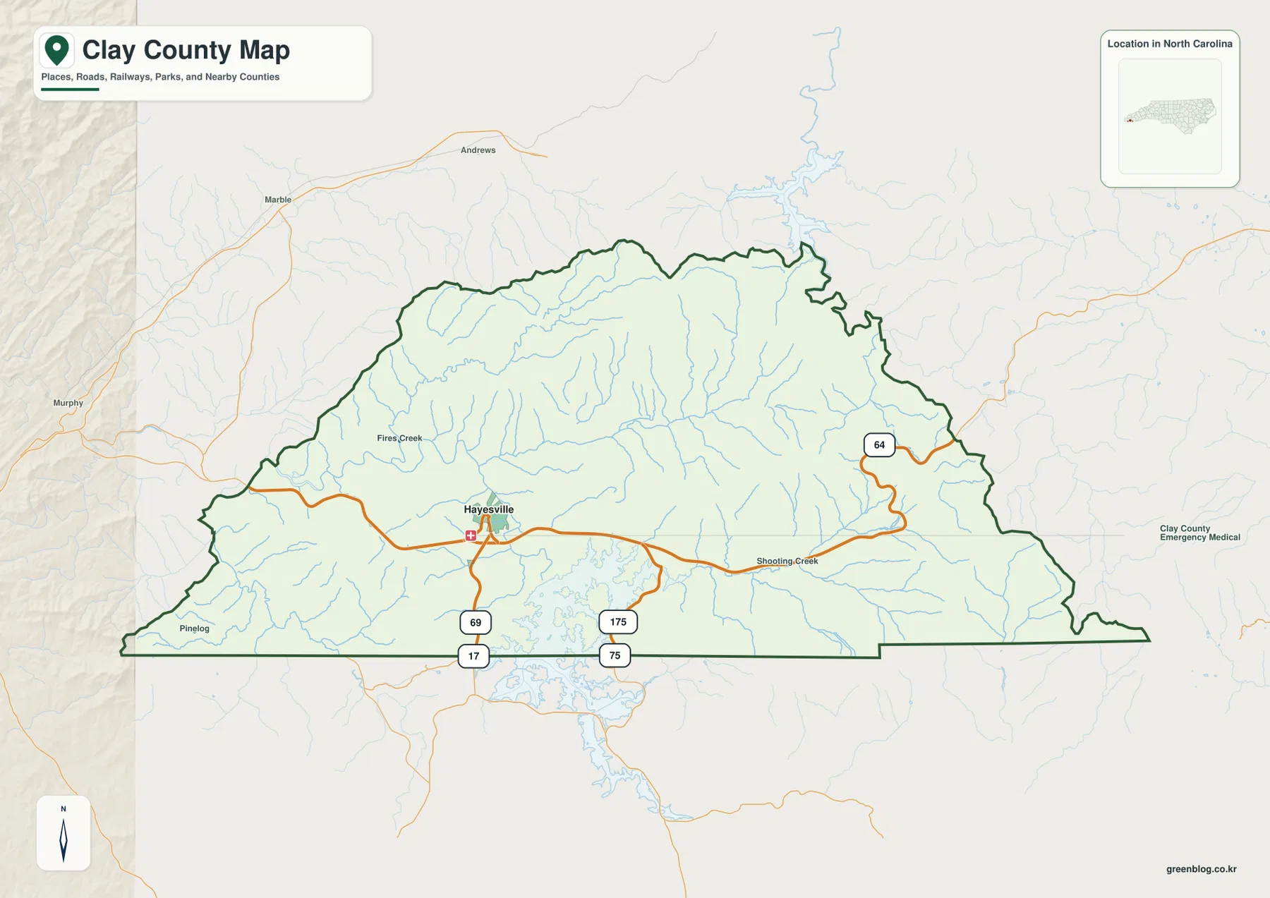
The wider frame also labels places outside Clay County, including Murphy, Marble, and Andrews to the west. Those names are useful because they show how Clay fits into the broader southwestern corner of North Carolina rather than leaving the county as an isolated outline. Inside the boundary, Fires Creek and Shooting Creek appear among the geographic labels. This map is therefore well suited to county-level orientation, but it should not be mistaken for a street-by-street navigation map or a legal parcel map.
What the simplified city view says about Hayesville’s role
The city map removes much of the road and stream detail and puts Hayesville in the foreground. Its city index lists Hayesville as the ranked major city shown for Clay County, while Cherokee, Graham, and Macon counties remain visible around the edge as regional references. That simplified treatment is useful in a small mountain county because it prevents a crowded collection of minor labels from competing with the principal place name. It does not mean that the rest of the county is empty; it means the map is designed to answer a narrower question about the location of the main urban reference.
Hayesville is not pushed to an extreme corner of the county. It sits in a relatively central valley position, with the irregular shoreline of Chatuge Lake just to the south on the underlying geography. When the smaller roads and creeks are muted, the relationship between Hayesville and the surrounding county boundaries becomes easier to see. The west side faces Cherokee County, the east side faces Macon County, and the north side reaches toward Graham County, while the state line closes the county on the south.
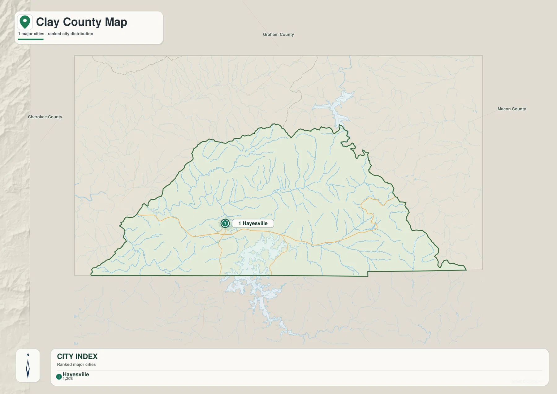
This view works particularly well when someone needs a quick regional reference before opening a more detailed road map. A reader can locate Hayesville first, decide whether the next direction is west toward Cherokee County or east toward Macon County, and then switch to the general map for numbered routes. Used beside the water map, it also shows how one central place fits into a landscape shaped by numerous creeks and a large reservoir rather than by a dense chain of cities.
The Hiwassee River, Chatuge Lake, and a web of mountain creeks
Water is one of the strongest geographic clues on the Clay County terrain and water map. The Hiwassee River is labeled across the western and central part of the county, while Chatuge Lake forms a broad, branching water body along the south-central edge. Numerous smaller streams descend from the surrounding mountain terrain and feed the larger system. The result is a drainage pattern that helps explain why the county’s roads and settled valleys curve so much: the usable low ground follows natural corridors rather than a rectangular survey grid.
Fires Creek stands out on the western side, with Carroll Lake labeled nearby. Farther east, Tusquitee Creek crosses the central part of the map and Downing Creek joins the network south of it. Shooting Creek is prominent in the southeast, while Bell Creek and several other named tributaries mark the eastern slopes. These labels make the water map much more than a decorative terrain image. They give the reader specific reference points for separating the western, central, and eastern mountain valleys within a compact county.
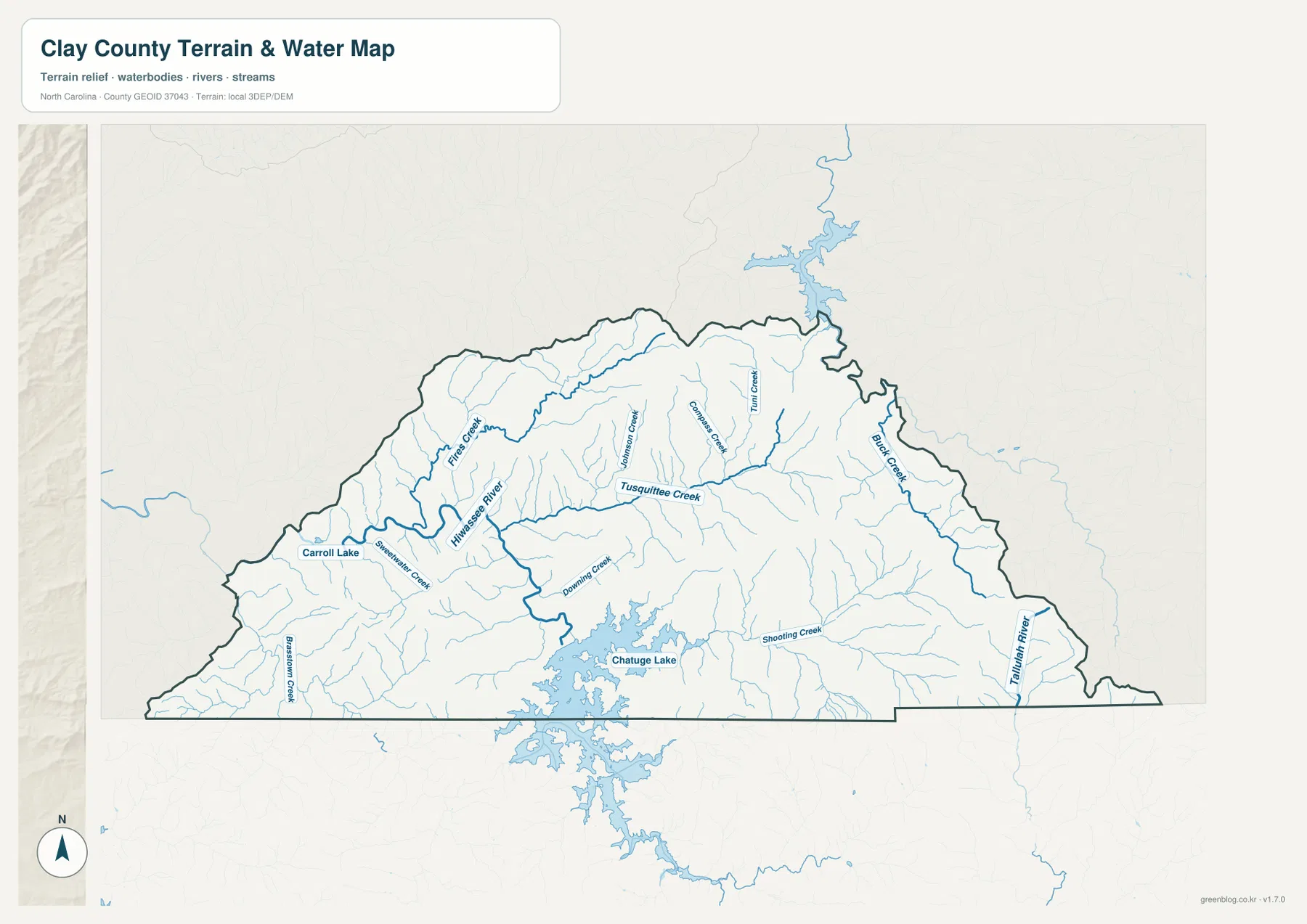
The shaded background provides a visual sense of ridges and valleys, but this package does not include a separate elevation map with measured heights. The relief should therefore be used to understand general terrain form, not to obtain an exact elevation for engineering, surveying, or construction. The water layer is likewise a geographic reference rather than a flood-risk, parcel-boundary, or navigation product. For those specialized purposes, an official dataset designed for the specific task is necessary.
Why the county looks different when roads, cities, and water are separated
Clay County is small enough to fit comfortably on one page, yet each map reveals a different part of its character. The general map is strongest for roads, county shape, Hayesville, and the Georgia border. The city view strips the scene down so the location of Hayesville relative to Cherokee, Graham, and Macon counties is immediately clear. The terrain and water view shifts attention away from roads and toward the Hiwassee system, Chatuge Lake, and the many tributaries cutting through the mountains. Comparing the three prevents one feature from standing in for the whole county.
If the goal is to explain where Hayesville is, the city map gives the fastest answer and the general map adds road context. If the goal is to locate Fires Creek, Tusquitee Creek, Shooting Creek, or the Hiwassee River, the water map is more useful. Chatuge Lake is visible as a major southern reference, so placing it beside the state line on the general map helps clarify the county’s southern geography. The best map therefore depends on whether the question concerns a place name, a driving corridor, the county boundary, or a natural water feature.
Choosing a file for print, classwork, or regional reference
For a report or classroom handout that needs the full county context, the general map is usually the most balanced choice because it combines roads, boundaries, and place labels. The simplified city map is cleaner when Hayesville needs to stand out in a presentation or comparison of neighboring counties. The terrain and water map is the better option for discussions centered on rivers, creeks, the reservoir, or the way valleys cut through the mountain landscape. None of the files is intended to replace legal, cadastral, real-time traffic, or emergency mapping.
The WebP images in the article are sized for quick viewing on the page. The ZIP below is intended for users who need the matching high-resolution JPG files for printing or placement in another document. Keeping the three files together also makes it easier to switch between road-oriented, city-oriented, and water-oriented views without repeatedly saving images from the page.
Frequently Asked Questions
Which map is easiest for locating Hayesville quickly?
The city map is the quickest choice because Hayesville is the highlighted major city reference. After locating it there, the general county map adds US 64, nearby numbered routes, the Georgia line, and surrounding place names. The water map is useful when the next question involves the Hiwassee River or Chatuge Lake.
Where can I see Chatuge Lake and the Hiwassee River together?
The terrain and water map shows both features along with Fires Creek, Tusquitee Creek, Shooting Creek, and other tributaries. It is designed for geographic orientation, not for determining flood zones, navigable channels, or legal shoreline boundaries.
Does this Clay County download include a separate elevation map?
No. This package contains the general county map, the city map, and the terrain-water map. The shaded terrain background gives a visual impression of mountain relief, but it is not a dedicated elevation product and should not be used for precise height measurements.
Map File Information
The ZIP contains the high-resolution JPG files that correspond to the supplied general county, city, and terrain-water maps.
- Included Files: 3 high-resolution JPG map files shown in this article: general county, city, and terrain-water maps
- File Type: JPG files in a ZIP archive
- Intended Use: Printing, education, presentations, and map-based projects
Related Maps
Sources and references
These references provide county background and authoritative boundary or hydrography information that can be used alongside the maps on this page.
Green Map creates custom-edited map images using open geographic data sources such as geoBoundaries, Natural Earth, OpenStreetMap, and government open data.
These maps are edited visual materials, not raw data files, and are provided for education, documents, presentations, and graphic reference.