Cleveland County is easiest to understand when Shelby is treated as the main central reference rather than the whole story. The county stretches north from the South Carolina line, while Kings Mountain forms a separate eastern focus and the Broad River and First Broad River give the western and central parts of the county strong natural reference points. The maps on this page show those relationships at county scale, and the matching high-resolution JPG map files are available together as a ZIP download.
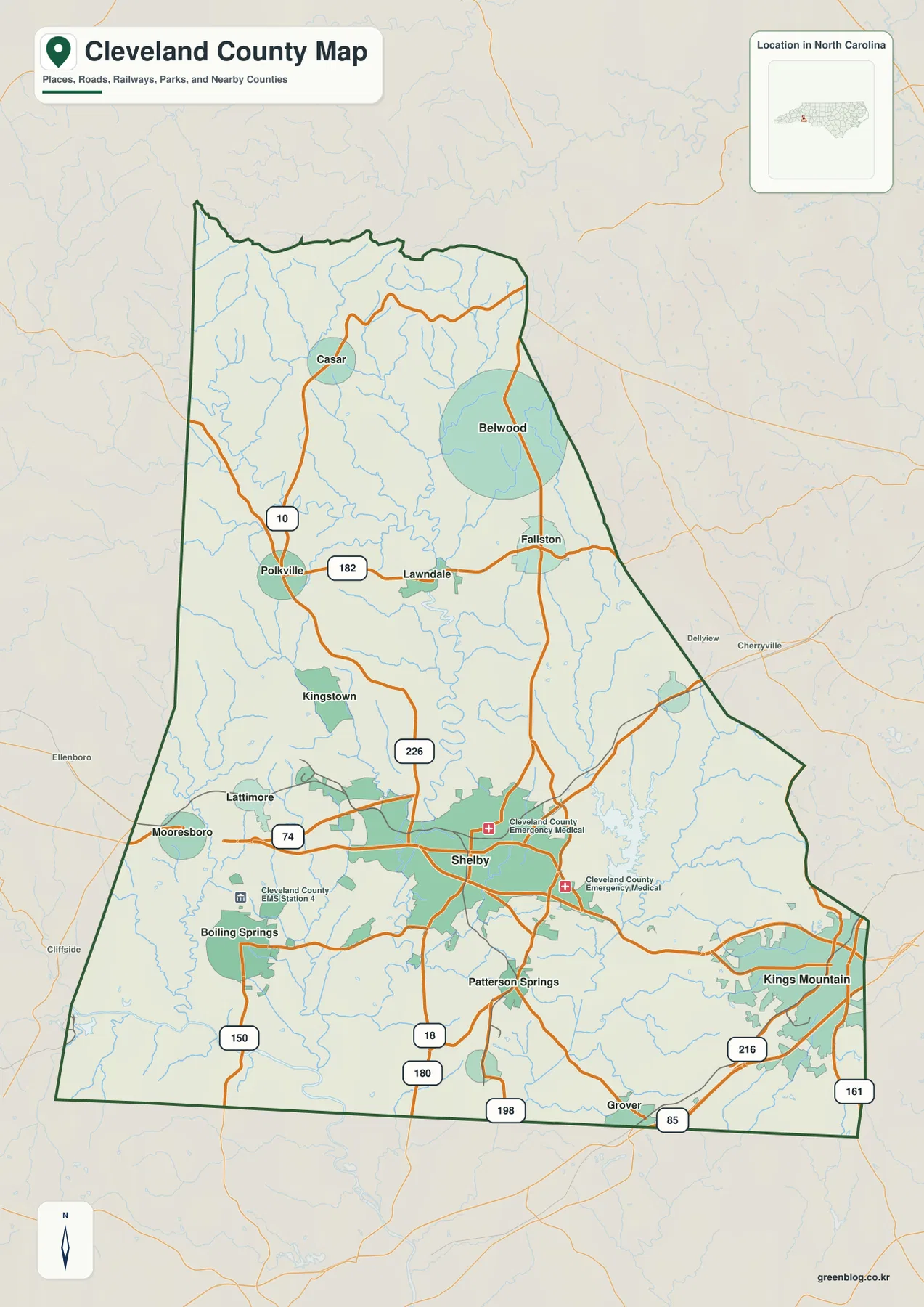
The county map emphasizes roads, communities, boundaries, and nearby counties. A second map reduces the clutter and highlights six major places so their distribution is easier to compare. The terrain and water map then shifts attention away from roads to rivers, creeks, reservoirs, and shaded relief. Taken together, the three views make it possible to move from Shelby and US 74 to the smaller northern communities and then to the waterways that cross the county without treating every feature as if it belonged on one overloaded map.
No separate elevation map is included in this package. The shaded relief on the water map can help show where the land looks more broken or smoother, but it does not provide survey-grade heights or point elevations. That distinction matters in Cleveland County because the visible terrain, river corridors, and road pattern already provide useful orientation without inventing elevation values that are not present in the supplied material.
Table of Contents
Shelby and US 74 provide the clearest starting line
Shelby occupies the broad developed area near the middle of the southern half of Cleveland County. US 74 approaches from the west near Mooresboro and Lattimore, crosses the Shelby area, and continues east toward Kings Mountain. That east-west route creates an easy visual reference for comparing communities that otherwise seem scattered across a tall north-south county. Boiling Springs lies southwest of Shelby, Patterson Springs is directly south, and Grover sits farther south near the state line. Kings Mountain is well to the east and appears as its own developed area rather than a simple extension of Shelby.
Other highways help separate the county into smaller pieces. NC 18 runs through Shelby and continues toward the southern boundary. NC 226 crosses the western side of the central county, while NC 150 appears farther southwest. North of Shelby, roads connect toward Lawndale, Fallston, Belwood, Polkville, and Casar. Near the southeastern corner, I-85 passes the Grover and Kings Mountain side of the county. This map is not a turn-by-turn navigation product, but it is useful for seeing which communities share the same general road direction before opening a detailed street map.
The surrounding labels also help with county-scale orientation. Rutherford County is to the west, Burke County is north of the upper part of Cleveland County, Lincoln County is toward the northeast, and Gaston County is on the eastern side. The southern edge is the North Carolina–South Carolina state line. These outer references are particularly useful when comparing Shelby with Kings Mountain: Shelby is positioned well inside the county, while Kings Mountain is much closer to the eastern edge and the Gaston County side.
The city map shows a strong southern concentration
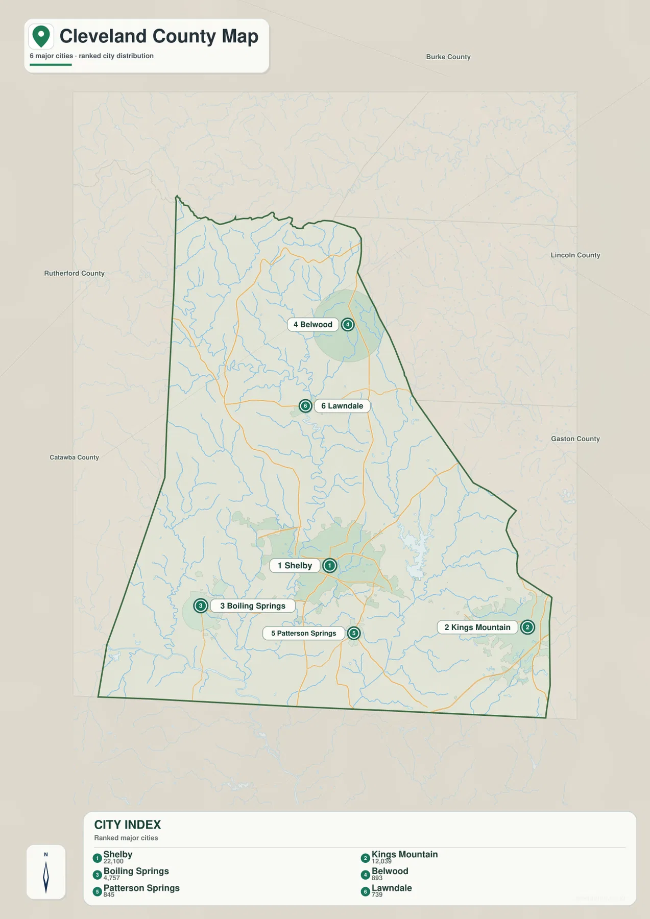
The city map simplifies Cleveland County to six labeled places and gives each one a ranked population figure as printed on the supplied map. Shelby is listed at 22,100 and Kings Mountain at 12,039. Boiling Springs is shown at 4,757, followed by Belwood at 893, Patterson Springs at 845, and Lawndale at 739. Those numbers are best treated as the values carried by this map rather than as a substitute for a current population database. Their main value here is to show the large difference between the two dominant southern cities and the much smaller communities farther north or outside the Shelby core.
The geographic pattern is as useful as the ranking. Shelby sits near the center of the southern half, while Kings Mountain is separated from it on the east. Boiling Springs is southwest of Shelby and Patterson Springs is just to the south, producing a cluster of labeled communities in the lower part of the county. Belwood and Lawndale are much farther north. When the city map is compared with the fuller county map, places such as Casar, Fallston, and Polkville add more detail to that northern half, but the overall contrast remains clear: the largest developed areas are concentrated around Shelby and the eastern Kings Mountain side.
This view is useful when a visitor knows a place name but not its position within the county. Someone looking for Boiling Springs can quickly see that it belongs to the southwestern side of the Shelby area, while a search for Belwood moves the eye well north. Kings Mountain should not be mentally folded into Shelby simply because both are prominent; the map leaves a visible gap between the two developed areas and shows different road connections around them. That separation is one of the most important features of Cleveland County at this scale.
Broad River and First Broad River organize the western and central waterways
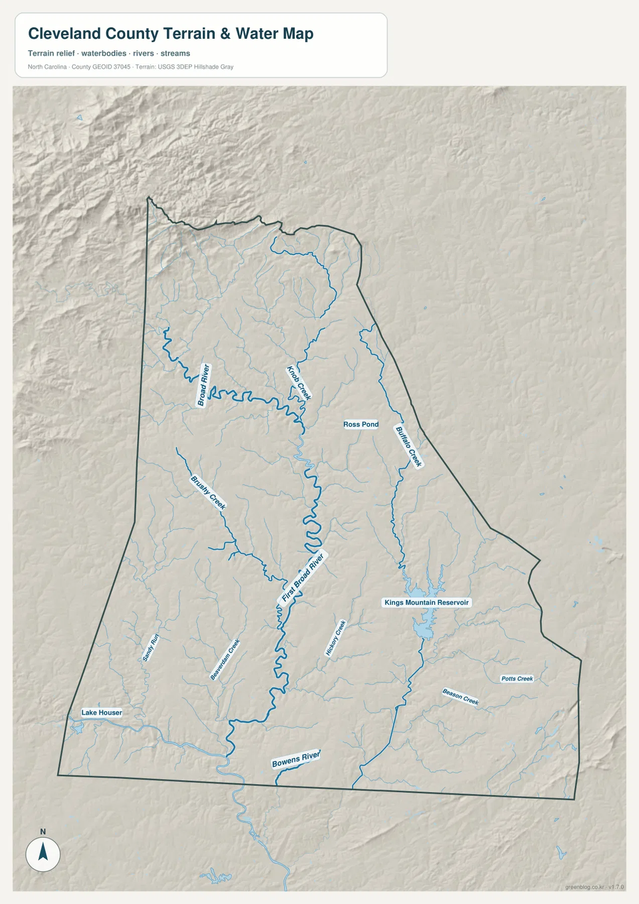
The terrain and water map changes the way Cleveland County is read. Broad River is the major named waterway on the western side, and First Broad River runs through the central part of the county before continuing south. Knob Creek approaches the First Broad River system from the north-central area, while Brushy Creek and Beaverdam Creek add smaller western tributaries. These streams are easy to overlook on the road map because the highway network is visually stronger there, but they become the main framework once roads and urban areas are removed.
The eastern side has a different set of water references. Buffalo Creek runs down the eastern portion of the county, and Kings Mountain Reservoir is clearly labeled farther south. Hickory Creek, Beason Creek, and Potts Creek appear around the reservoir and southeastern drainage area. The map also labels Bowens River near the southern boundary, Sandy Run on the western side, Lake Houser in the southwest, and Ross Pond farther north and east of the First Broad River. This is a reference map for relative location and terrain context, not a flood-risk, legal-water-boundary, boating, or engineering map.
The shaded relief is noticeably more textured along parts of the northwestern and western side, while broader areas around Shelby and toward the southeast appear smoother. Because the map does not include elevation numbers, that texture should be read only as a relative indication of terrain shape. It is enough to show why a waterway may bend through a more broken landscape or why small tributaries are dense in certain parts of the county, but it should not be converted into precise height differences. For exact elevation measurements, a separate elevation dataset would be needed.
Use each view for a different Cleveland County question
For most visitors, the county map is the best first view because it connects names with roads and the county boundary. It answers questions such as whether Grover is south or east of Shelby, whether Kings Mountain lies on the same side of the county as Rutherford County, or which route runs through the main Shelby corridor. The city map becomes more useful when the question is about relative settlement size and distribution. It removes much of the road detail and makes the distance between the large southern places and the smaller northern communities easier to see.
The water map is the better choice when the city names are already familiar and the goal is to understand the physical setting. First Broad River gives the central county a strong north-south natural reference, Broad River frames much of the western side, and Kings Mountain Reservoir provides a distinct eastern water feature. Switching between the road-oriented map and the water-oriented map can also prevent a common mistake: assuming that the county’s most visible highways and its most important waterways follow the same paths. They often cross or occupy different parts of the landscape.
A practical sequence is to find Shelby and US 74 first, locate the destination community on the city map, and then check the nearest river, creek, or reservoir on the water map. For example, Kings Mountain sits east of Shelby on the main road view, while the terrain-and-water view shows Kings Mountain Reservoir and the Buffalo Creek system on the same eastern side. Western locations, by contrast, are more closely associated with Broad River and its tributaries. This simple sequence provides county context before a visitor moves to a specialized parcel, trail, street, or navigation map.
The downloadable archive contains the same three map types shown on the page as high-resolution JPG files. Each JPG is 2572×3638 pixels, making the originals more suitable than the WebP previews when a larger image is needed for printing or close inspection. The archive name is cleveland_county_north_carolina_3_map_jpg.zip, so the county and state remain clear after the file is saved.
Frequently Asked Questions
How should Shelby and Kings Mountain be used as separate map references?
Shelby is the main central reference in the southern half of Cleveland County, while Kings Mountain is a separate eastern focus near the Gaston County side. US 74 connects the general direction between them, but the developed areas are shown separately. Using Shelby as the central reference and Kings Mountain as the eastern reference makes it easier to place Boiling Springs, Patterson Springs, Grover, and the northern communities.
Which map is best for finding First Broad River and Kings Mountain Reservoir?
The terrain and water map is the clearest option. First Broad River is labeled through the central county, Broad River appears on the western side, and Kings Mountain Reservoir is marked in the east-southeastern portion. The same map also labels Buffalo Creek, Knob Creek, Brushy Creek, and several smaller waterways that are less prominent on the road-focused county map.
What is included in the Cleveland County download?
The ZIP contains three high-resolution JPG files matching the county map, city map, and terrain-and-water map shown on this page. A separate elevation map is not included. The JPG originals are 2572×3638 pixels each and are intended for visitors who need a larger file than the WebP preview displayed in the article.
Sources and Reference Data
The geographic descriptions above are based first on the supplied Cleveland County map package. The following references are useful for checking county background, boundary data, and hydrography.
Map File Information
Download the Cleveland County county map, city map, and terrain-and-water map together as high-resolution JPG files.
- Included Versions: county map, city map, terrain and water map
- Included Files: 3 JPG maps
- Printable Size: 2572×3638 pixels each
Related Maps
Green Map creates custom-edited map images using open geographic data sources such as geoBoundaries, Natural Earth, OpenStreetMap, and government open data.
These maps are edited visual materials, not raw data files, and are provided for education, documents, presentations, and graphic reference.