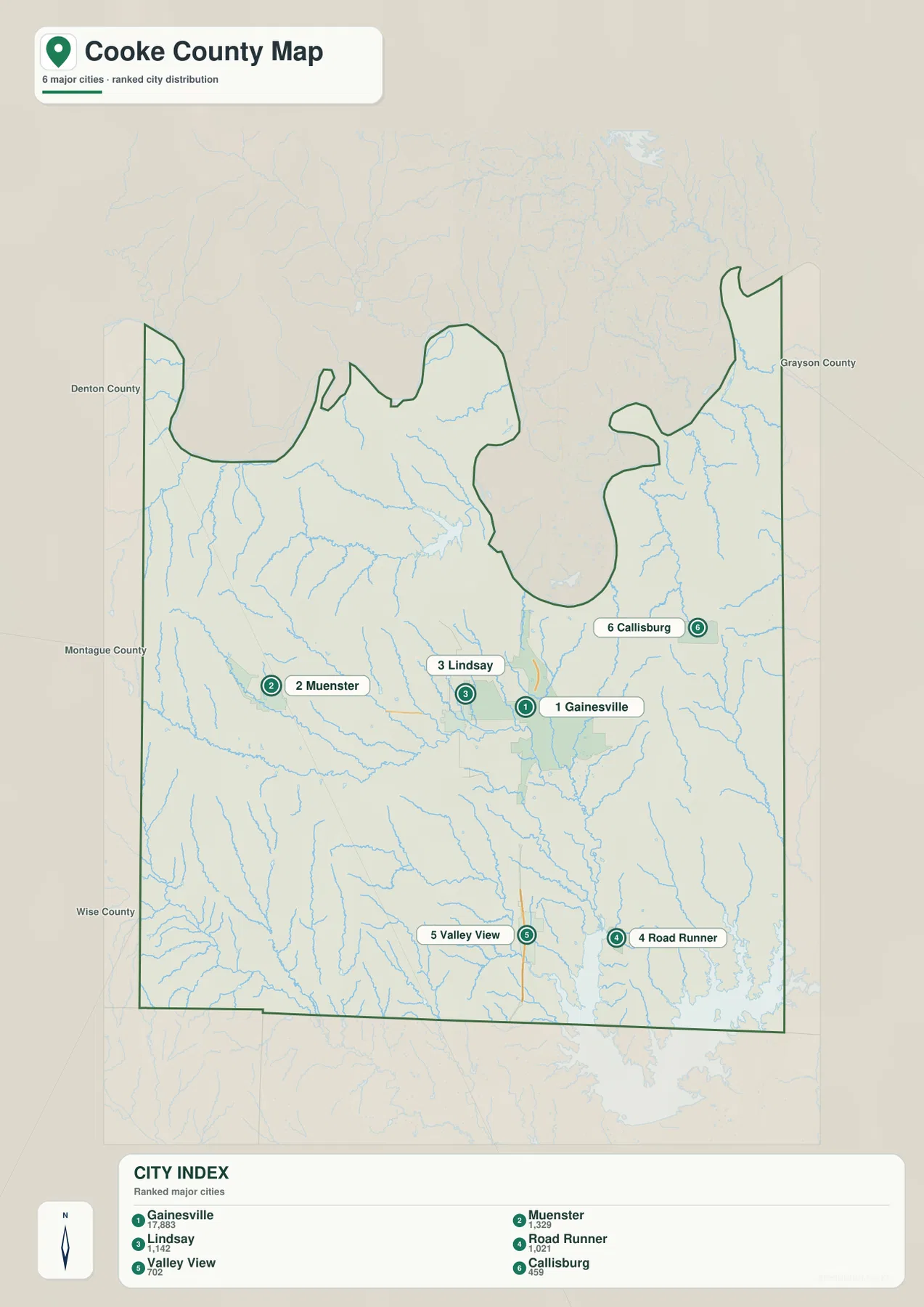
Cooke County in North Texas combines the busy Gainesville road hub with a winding Red River boundary, higher rolling terrain in the west, and broad lake-and-creek lowlands toward the southeast. Interstate 35 and US 82 meet at Gainesville, Muenster and Lindsay lie to the west, Callisburg is east of the county seat, and Valley View and Road Runner provide southern references. The terrain-and-water map adds Red River, Elm Fork Trinity River, Pecan Creek, Indian Creek, Timber Creek, Hubert H Moss Lake, Lake Kiowa, and Ray Roberts Lake. Elevation ranges from about 183 to 382 meters with a mean near 255 meters, creating a clear contrast between the western uplands and the lower eastern and southeastern drainage country. The county, city, water, and elevation maps shown in this article are also available together as four high-resolution A3 JPG files in the ZIP download.
Gainesville is the best place to establish orientation. US 82 stretches west toward Lindsay and Muenster and east toward Callisburg, while I-35 runs north toward the Red River and south toward Valley View. The road map looks relatively simple at first, but the physical maps show strong differences around those corridors. Western Cooke County rises into pronounced hills cut by narrow creeks, while Lake Kiowa and Ray Roberts Lake sit in much lower terrain toward the southeast.
Table of Contents
Gainesville Sits at the I-35 and US 82 Crossroads
Gainesville has the strongest road concentration on the general county map. Interstate 35 passes through the city from south to north, and US 82 crosses it from west to east. North Central Texas College and Freedom Field are labeled nearby, while the Lindsay side includes a police-department marker. Those landmarks make Gainesville easy to locate before the reader moves into the county’s more rural areas.
Following US 82 west leads through Lindsay and toward Muenster, with Myra labeled farther south of the corridor. Continuous urban development disappears quickly outside Gainesville. The western half contains many short blue drainage lines and a more rugged surface, so the road corridor crosses a landscape that is physically different from the lower eastern side.
East of Gainesville, US 82 continues toward Callisburg. Lake Kiowa lies southeast of the city, while Road Runner and Valley View provide additional southern references. I-35 reaches Valley View and continues toward Denton County, giving the map a simple north-south spine even though the surrounding drainage becomes increasingly complex near Ray Roberts Lake.
The northern boundary is shaped by the Red River and is highly irregular. Large bends and narrow projections make the county outline very different from a simple rectangle. I-35 approaches that river corridor from Gainesville, but the water and elevation maps show that the northern edge is a low drainage landscape rather than just a jurisdictional line.
Six Ranked Places Show a Strong Gainesville Center and Wide Rural Spread
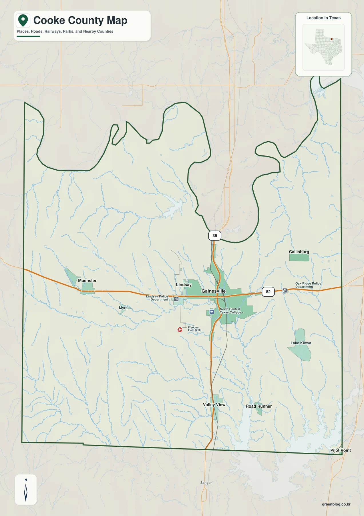
The ranked city map lists six places. Gainesville is first at 17,883, followed by Muenster at 1,329 and Lindsay at 1,142. Road Runner is shown at 1,021, Valley View at 702, and Callisburg at 459. The Gainesville value is far larger than the others, but the geography of the six points matters just as much: the smaller communities are spread west, east, and south across a broad county.
Muenster and Lindsay form the clearest western pair, while Callisburg sits on the eastern side. Valley View and Road Runner are both southern references and help orient the map toward Ray Roberts Lake and the Denton County side. Their positions show that Cooke County extends well beyond the immediate Gainesville area even though the largest built-up footprint is concentrated near the central road junction.
No connector lines or mileage labels are printed on the ranked city map. The CITY INDEX figures should therefore not be treated as distances or travel times. For actual road relationships, the general map is better; for the terrain between the points, the water and elevation layers explain far more than the simplified city ranking.
Neighboring county labels include Montague, Wise, Denton, and Grayson counties. Muenster sits closer to the Montague County side, Valley View is near the Denton County direction, and Callisburg lies toward Grayson County. These relationships provide useful regional orientation without assuming that every selected city serves the same part of the county.
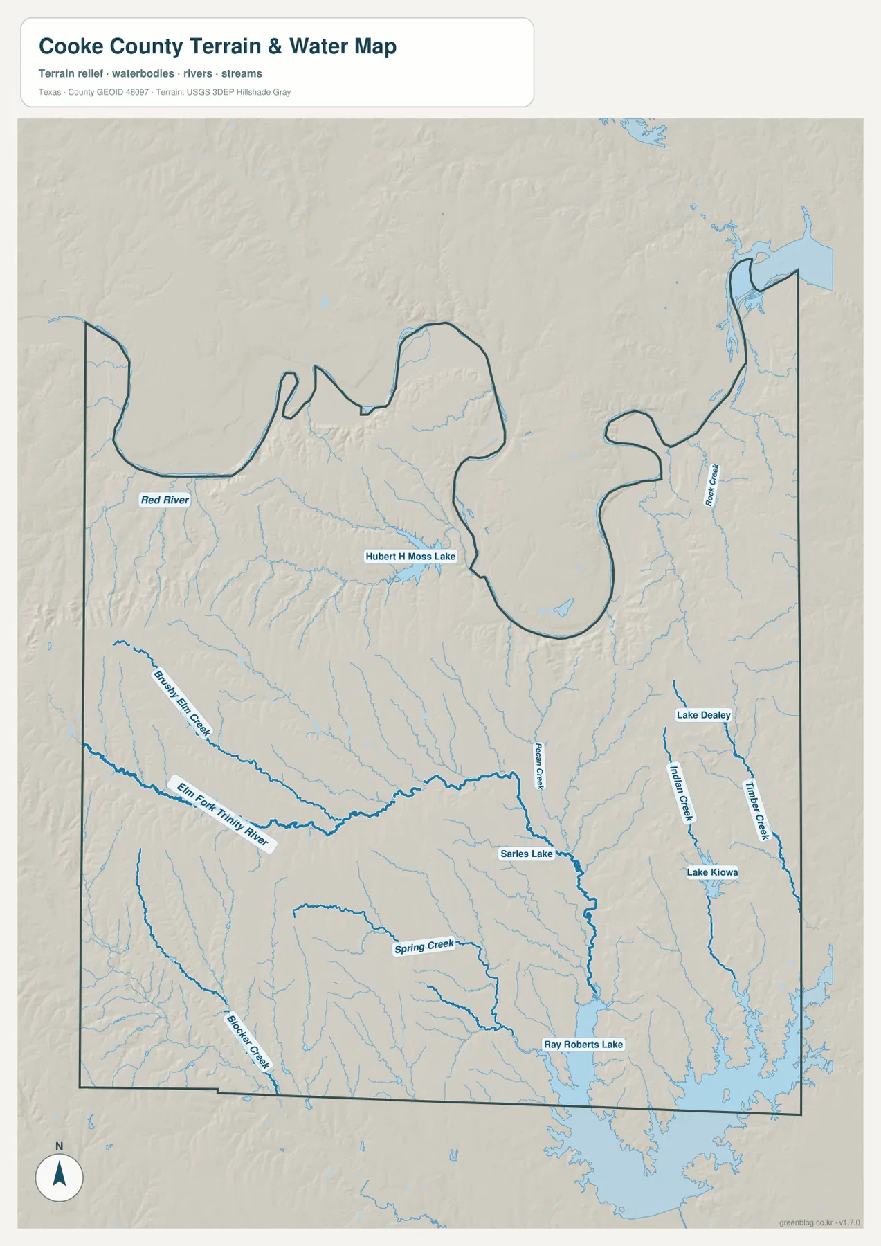
Red River, Elm Fork Trinity River, and Ray Roberts Lake Organize the Water Map
Red River is the dominant northern water reference. It follows the county’s winding border, producing the irregular outline visible on the general map. Hubert H Moss Lake lies south of the river in the northwestern-central part of the county and provides another large water landmark below the boundary.
Brushy Elm Creek and Elm Fork Trinity River are prominent in the western and central interior. They collect numerous smaller tributaries and follow low valleys toward the east and southeast. Pecan Creek is another long channel closer to Gainesville and continues south past Sarles Lake toward the broader southern drainage network.
Indian Creek and Timber Creek create two long eastern valleys, with Lake Dealey and Lake Kiowa nearby. Farther south, Spring Creek leads toward Ray Roberts Lake, while Blocker Creek provides a southwestern reference. These features make the southeastern county one of the most water-rich parts of the map and help explain the extensive low terrain visible on the elevation layer.
This terrain-and-water image is intended for general geographic reference. It is not a flood-hazard map, parcel or legal-boundary map, depth chart, water-quality report, fishing-status guide, or navigation product. Those questions require specialized official data. For ordinary map reading, Red River, Elm Fork Trinity River, Pecan Creek, Indian Creek, Lake Kiowa, and Ray Roberts Lake provide the clearest framework.
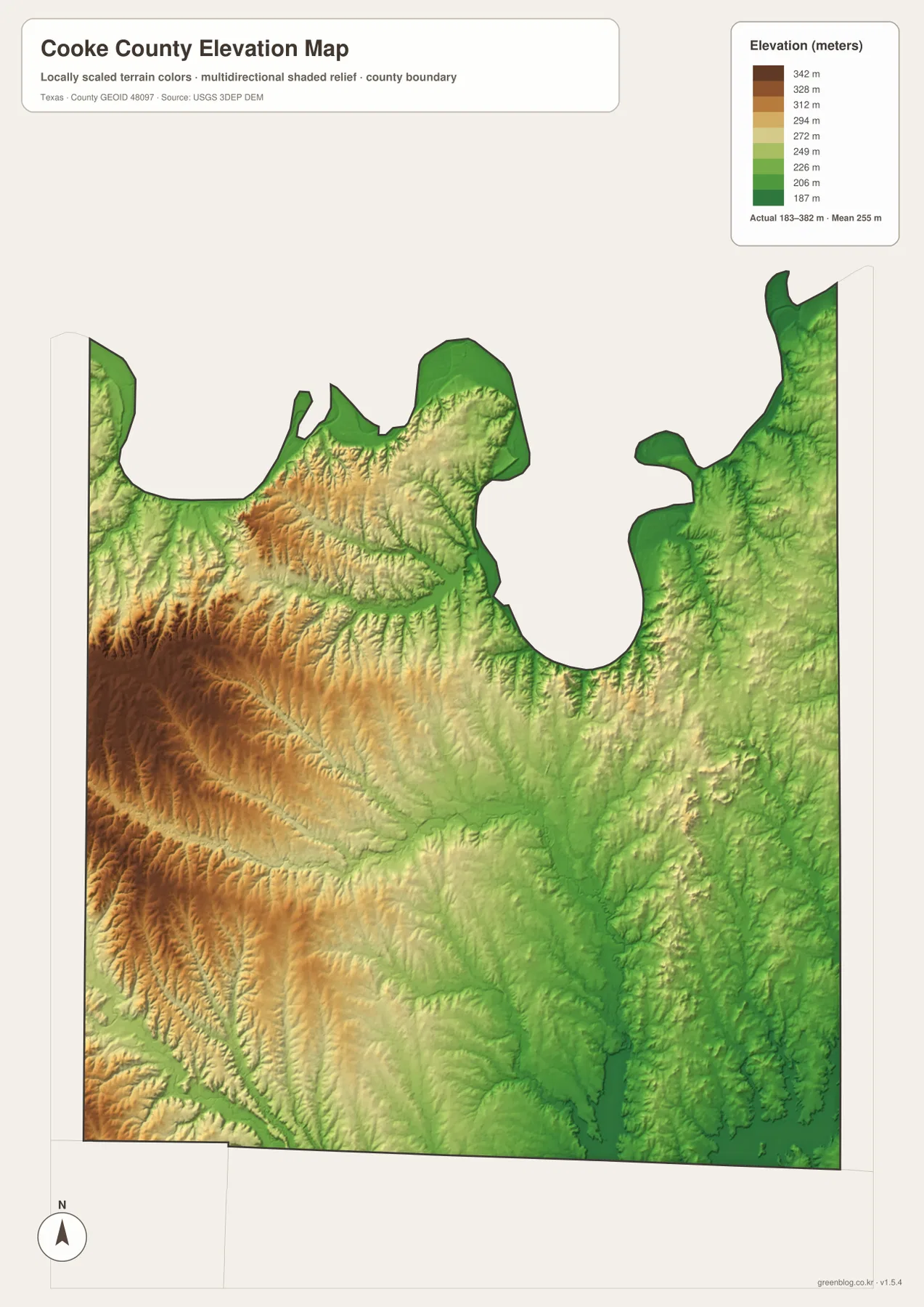
Elevation from About 183 to 382 Meters Highlights the Western Uplands
The supplied elevation map reports an actual range of approximately 183 to 382 meters and a mean near 255 meters. The highest dark-brown terrain is concentrated in the west and southwest, with a broad upland zone extending through the west-central county. The east and southeast are greener and generally lower, especially in the long creek corridors and around Ray Roberts Lake.
The western uplands are deeply cut rather than flat. Narrow green valleys repeatedly enter the brown and orange ridges, and many correspond with the small tributaries visible on the water map. Elevation also drops toward the Red River along parts of the northwest, but the high west-central terrain remains one of the strongest visual features in Cooke County.
East and southeast of Gainesville, lower terrain becomes much more extensive. Pecan Creek, Indian Creek, and Timber Creek occupy long green corridors, while the Ray Roberts Lake basin forms one of the broadest low areas on the map. Lake Kiowa is also set within lower country than the western Muenster side, reinforcing the county’s strong west-to-southeast contrast.
This elevation surface is suitable for county-scale comparison, not survey or engineering measurement. It should not be used to determine the precise elevation of a house, parcel corner, road grade, or construction site. The 183–382 meter range and 255 meter mean are best treated as broad reference values for comparing the western uplands, the Red River valley, and the lower eastern creek and lake country.
The County Changes from Muenster Hills to the Lake Kiowa–Ray Roberts Lowlands
The most useful terrain comparison begins at Gainesville. Travel west along the US 82 side toward Lindsay and Muenster and the map rises into stronger uplands cut by many narrow tributaries. Move east and south from Gainesville and the pattern changes: Pecan Creek, Indian Creek, Lake Kiowa, and eventually Ray Roberts Lake occupy a much broader lowland landscape.
Valley View and Road Runner help make that southern change visible. On the ranked city map they are simply two southern points, but the water layer places them closer to Spring Creek and the Ray Roberts drainage, while the elevation map shows an extensive low green basin. Muenster and Lindsay, by contrast, sit closer to the higher and more rugged western terrain.
The Red River adds a second lowland reference in the north. Its valley is low, yet high western ridges rise not far to the south, producing substantial local relief. Locating Gainesville, Muenster, Callisburg, and Valley View first and then comparing the water and elevation maps makes the county’s physical diversity much clearer than a simple “North Texas plain” description would.
Choose the File by Roads, City Ranking, Water, or Elevation
The general county map is the best single reference for Gainesville, Muenster, Lindsay, Callisburg, Valley View, I-35, and US 82. The ranked city map is cleaner when the goal is to compare the six selected places and their distribution. The terrain-and-water map is the best choice for Red River, Elm Fork Trinity River, Pecan Creek, Indian Creek, Lake Kiowa, and Ray Roberts Lake. The elevation map most clearly shows the difference between the high western uplands and the lower eastern and southeastern drainage country.
Small creek labels and minor road details can be difficult to read in a reduced browser preview. The original JPG files are more convenient for enlargement and printing. They also work well for side-by-side comparison with Montague, Wise, Denton, Grayson, or other North Texas counties when the same map type and a similar display scale are used.
The ZIP below contains four high-resolution A3 JPG files corresponding to the county, city, water, and elevation maps shown in the article. They can be enlarged for detailed label reading, printed for classroom or personal reference, or arranged with neighboring county maps for regional comparison.
Frequently Asked Questions
Which place ranks first on the supplied Cooke County city map?
Gainesville ranks first at 17,883 on the supplied CITY INDEX. Muenster is shown at 1,329, Lindsay at 1,142, Road Runner at 1,021, Valley View at 702, and Callisburg at 459. The map does not show mileage lines between these places.
Where are Red River and Ray Roberts Lake on the map?
Red River follows the winding northern county boundary, while Ray Roberts Lake occupies a broad area near the southeastern edge. Elm Fork Trinity River, Pecan Creek, Indian Creek, and other channels cross the county between those two major water references.
Which part of Cooke County is highest on the supplied elevation map?
The west and southwest contain much of the highest terrain. The map reports an elevation range of about 183–382 meters with a mean near 255 meters, while the eastern creek valleys and Ray Roberts Lake basin occupy lower ground.
Sources and Reference Data
- U.S. Census Bureau TIGER/Line Shapefiles — official geographic boundary, road, and place data.
- USGS National Hydrography — official information about rivers, creeks, lakes, and hydrography.
- USGS 3D Elevation Program — official elevation and terrain data information.
- USGS The National Map Viewer — interactive access to boundaries, transportation, hydrography, terrain, and other geographic layers.
Map File Information
Download the Cooke County county, city, water, and elevation maps together as high-resolution A3 JPG files.
- Included Files: 4 maps
- File Type: JPG
Related Maps
- Wise County Texas map
- Tarrant County Texas map
- Rockwall County Texas map
- Archer County Texas map
- Wichita County Texas map
Green Map creates custom-edited map images using open geographic data sources such as geoBoundaries, Natural Earth, OpenStreetMap, and government open data.
These maps are edited visual materials, not raw data files, and are provided for education, documents, presentations, and graphic reference.